More like 'Interview with Norm and Kathleen Henderson by Eric Damer October 25, 2012 - Track 1'
Narrow Results By
Decade
- 2020s 96
- 2010s 43
- 2000s 481
- 1990s 398
- 1980s 405
- 1970s 942
- 1960s 279
- 1950s 463
- 1940s 412
- 1930s 351
- 1920s 368
- 1910s 439
- 1900s 172
- 1890s 24
- 1880s 49
- 1870s 3
- 1860s 1
- 1850s 1
- 1840s 1
- 1830s 1
- 1820s 1
- 1810s 1
- 1800s 1
- 1790s 1
- 1780s 1
- 1770s 1
- 1760s 1
- 1750s 1
- 1740s 1
- 1730s 1
- 1720s 1
- 1710s 1
- 1700s 1
- 1690s 1
- 1680s 1
- 1670s 1
- 1660s 1
- 1650s 1
- 1640s 1
- 1630s 1
- 1620s 1
- 1610s 1
- 1600s 1
Subject
- Accidents - Automobile Accidents 1
- Adornment 1
- Advertising Medium 4
- Advertising Medium - Signs and Signboards 95
- Aerial Photographs 27
- Agricultural Tools and Equipment - Plows 3
- Agriculture 4
- Agriculture - Crops 2
- Agriculture - Dairy 1
- Agriculture - Farms 57
- Agriculture - Fruit and Berries 8
- Agriculture - Poultry 4

Lougheed Hotel
https://search.heritageburnaby.ca/link/archivedescription93625
- Repository
- City of Burnaby Archives
- Date
- October 23, 1977
- Collection/Fonds
- Burnaby Public Library Contemporary Visual Archive Project
- Description Level
- Item
- Physical Description
- 1 photograph : b&w ; 12.5 x 17.5 cm
- Scope and Content
- Photograph of the Lougheed Hotel on Lougheed Highway near Willingdon Avenue. The photograph is taken facing west and shows the hotel's sign, parking lot, and main hotel building.
- Repository
- City of Burnaby Archives
- Date
- October 23, 1977
- Collection/Fonds
- Burnaby Public Library Contemporary Visual Archive Project
- Physical Description
- 1 photograph : b&w ; 12.5 x 17.5 cm
- Description Level
- Item
- Record No.
- 556-582
- Access Restriction
- No restrictions
- Reproduction Restriction
- Reproduce for fair dealing purposes only
- Accession Number
- 2017-57
- Scope and Content
- Photograph of the Lougheed Hotel on Lougheed Highway near Willingdon Avenue. The photograph is taken facing west and shows the hotel's sign, parking lot, and main hotel building.
- Names
- Lougheed Hotel
- Media Type
- Photograph
- Photographer
- Surridge, Jack
- Notes
- Title taken from project information form
- Accompanied by a project information form and 1 photograph (b&w negative ; 9.5 x 12.5 cm)
- BPL no. 29
- Street Address
- 4343 Lougheed Highway
- Historic Neighbourhood
- Vancouver Heights (Historic Neighbourhood)
- Planning Study Area
- Willingdon Heights Area
Images

![Lougheed Hotel, [1960] thumbnail](/media/hpo/_Data/_Archives_Images/_Unrestricted/001/078-001.jpg?width=280)
Lougheed Hotel
https://search.heritageburnaby.ca/link/archivedescription34644
- Repository
- City of Burnaby Archives
- Date
- [1960]
- Collection/Fonds
- Burnaby Historical Society fonds
- Description Level
- Item
- Physical Description
- 1 photograph : b&w ; 18.3 x 24.2 cm
- Scope and Content
- Photograph of the Lougheed Hotel on Lougheed Highway. Electric "Hotel" and "Vacancy" signs can be seen. A board advertises, "Smorgasbord Fri & Sat April 4th On, Ph GL 0221." "TV" is also advertised.
- Repository
- City of Burnaby Archives
- Date
- [1960]
- Collection/Fonds
- Burnaby Historical Society fonds
- Subseries
- Photographs subseries
- Physical Description
- 1 photograph : b&w ; 18.3 x 24.2 cm
- Description Level
- Item
- Record No.
- 078-001
- Access Restriction
- No restrictions
- Reproduction Restriction
- Reproduce for fair dealing purposes only
- Accession Number
- BHS2007-04
- Scope and Content
- Photograph of the Lougheed Hotel on Lougheed Highway. Electric "Hotel" and "Vacancy" signs can be seen. A board advertises, "Smorgasbord Fri & Sat April 4th On, Ph GL 0221." "TV" is also advertised.
- Names
- Lougheed Hotel
- Media Type
- Photograph
- Notes
- Title based on contents of photograph
- Geographic Access
- Lougheed Highway
- Street Address
- 4343 Lougheed Highway
- Historic Neighbourhood
- Vancouver Heights (Historic Neighbourhood)
- Planning Study Area
- Willingdon Heights Area
Images
![Lougheed Hotel, [1960] thumbnail](/media/hpo/_Data/_Archives_Images/_Unrestricted/001/078-001.jpg)
Martin's Auto Villa
https://search.heritageburnaby.ca/link/museumdescription15062
- Repository
- Burnaby Village Museum
- Date
- 5 Oct. 1946
- Collection/Fonds
- Elmer Wilson Martin fonds
- Description Level
- Item
- Physical Description
- 1 photograph : b&w ; 7 x 11.5 cm
- Scope and Content
- Photograph of Martin's Auto Villa on Hastings Street. Two cars are parked outside. A building in the foreground of the photograph appears to be under construction.
- Repository
- Burnaby Village Museum
- Collection/Fonds
- Elmer Wilson Martin fonds
- Description Level
- Item
- Physical Description
- 1 photograph : b&w ; 7 x 11.5 cm
- Scope and Content
- Photograph of Martin's Auto Villa on Hastings Street. Two cars are parked outside. A building in the foreground of the photograph appears to be under construction.
- Geographic Access
- Hastings Street
- Street Address
- 6574 Hastings Street
- Accession Code
- BV019.37.37
- Access Restriction
- No restrictions
- Reproduction Restriction
- No known restrictions
- Date
- 5 Oct. 1946
- Media Type
- Photograph
- Historic Neighbourhood
- Lochdale (Historic Neighbourhood)
- Planning Study Area
- Lochdale Area
- Scan Resolution
- 600
- Scan Date
- February 4, 2021
- Scale
- 100
- Notes
- Title based on contents of photograph
- Note in blue ink on verso of photograph reads: "Oct. 5th 1946"
- Stamp in black ink on verso of photograph reads: "992"
Images

![Nelson Bungalow Court, [between 1958 and 196-] thumbnail](/media/hpo/_Data/_Archives_Images/_Unrestricted/580/582-001.jpg?width=280)
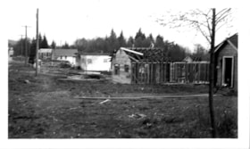
Nelson Bungalow Court
https://search.heritageburnaby.ca/link/archivedescription88412
- Repository
- City of Burnaby Archives
- Date
- [between 1958 and 196-]
- Collection/Fonds
- Krewenchuk family fonds
- Description Level
- Item
- Physical Description
- 1 photograph : b&w ; 8 x 11.5 cm
- Scope and Content
- Photograph of the Nelson Bungalow Court (also known as The Nelson Motel and The Nelson Auto Court) located at 6550 Nelson Avenue. The motel was owned and operated by Michael and Mary Krewenchuk between 1957 to 1967. The building in the photo was the family home and office for the motel on one acre …
- Repository
- City of Burnaby Archives
- Date
- [between 1958 and 196-]
- Collection/Fonds
- Krewenchuk family fonds
- Physical Description
- 1 photograph : b&w ; 8 x 11.5 cm
- Description Level
- Item
- Record No.
- 582-001
- Access Restriction
- No restrictions
- Reproduction Restriction
- No restrictions
- Accession Number
- 2015-05
- Scope and Content
- Photograph of the Nelson Bungalow Court (also known as The Nelson Motel and The Nelson Auto Court) located at 6550 Nelson Avenue. The motel was owned and operated by Michael and Mary Krewenchuk between 1957 to 1967. The building in the photo was the family home and office for the motel on one acre of land with eight cabins and seven trailors for lease. Lobely Park was located behind the house on adjacent property. The house is surrounded by trees including a monkey puzzle tree standing in front near a lampost with a totem pole design.
- Media Type
- Photograph
- Notes
- Title based on contents of photograph
- Street Address
- 6550 Nelson Avenue
- Historic Neighbourhood
- Central Park (Historic Neighbourhood)
- Planning Study Area
- Windsor Area
Images
![Nelson Bungalow Court, [between 1958 and 196-] thumbnail](/media/hpo/_Data/_Archives_Images/_Unrestricted/580/582-001.jpg)
![Painting the Hilton Hotel, [1999] thumbnail](/media/hpo/_Data/_Archives_Images/_Unrestricted/535/535-3353.jpg?width=280)
Painting the Hilton Hotel
https://search.heritageburnaby.ca/link/archivedescription98343
- Repository
- City of Burnaby Archives
- Date
- [1999]
- Collection/Fonds
- Burnaby NewsLeader photograph collection
- Description Level
- Item
- Physical Description
- 1 photograph (tiff) : col.
- Scope and Content
- Photograph of Krystian Litwinski, a foreman for Concord Painting, painting the awning of the Hilton Hotel in the Crystal in Metrotown before its opening.
- Repository
- City of Burnaby Archives
- Date
- [1999]
- Collection/Fonds
- Burnaby NewsLeader photograph collection
- Physical Description
- 1 photograph (tiff) : col.
- Description Level
- Item
- Record No.
- 535-3353
- Access Restriction
- No restrictions
- Reproduction Restriction
- No restrictions
- Accession Number
- 2018-12
- Scope and Content
- Photograph of Krystian Litwinski, a foreman for Concord Painting, painting the awning of the Hilton Hotel in the Crystal in Metrotown before its opening.
- Names
- Metrotown
- Media Type
- Photograph
- Photographer
- Bartel, Mario
- Notes
- Title based on caption
- Collected by editorial for use in an October 1999 issue of the Burnaby NewsLeader
- Caption from metadata: "Krystian Litwinski, a foreman for Concord Painting, gets the awning over the entrance to the new Hilton Hotel at the Crystal, ready for its opening."
- Geographic Access
- McKay Avenue
- Street Address
- 6083 McKay Avenue
- Historic Neighbourhood
- Central Park (Historic Neighbourhood)
- Planning Study Area
- Maywood Area
Images
![Painting the Hilton Hotel, [1999] thumbnail](/media/hpo/_Data/_Archives_Images/_Unrestricted/535/535-3353.jpg)
![Royal Oak Hotel, [1911] thumbnail](/media/hpo/_Data/_Archives_Images/_Unrestricted/371/449-010.jpg?width=280)
Royal Oak Hotel
https://search.heritageburnaby.ca/link/archivedescription38515
- Repository
- City of Burnaby Archives
- Date
- [1911]
- Collection/Fonds
- Burnaby Historical Society fonds
- Description Level
- Item
- Physical Description
- 1 photograph : b&w postcard ; 8.5 x 14 cm
- Scope and Content
- Photographic postcard of the Royal Oak Hotel at Kingsway and Royal Oak (3501 Kingsway, old street numbering). Three men (who have been identified by a note on the back of the card as Andrew Johnson, T.C. Hicks and W. Hicks) can be seen standing at the front steps of the hotel while a Burnaby Police…
- Repository
- City of Burnaby Archives
- Date
- [1911]
- Collection/Fonds
- Burnaby Historical Society fonds
- Subseries
- Photographs subseries
- Physical Description
- 1 photograph : b&w postcard ; 8.5 x 14 cm
- Description Level
- Item
- Record No.
- 449-010
- Access Restriction
- No restrictions
- Reproduction Restriction
- No known restrictions
- Accession Number
- BHS2007-04
- Scope and Content
- Photographic postcard of the Royal Oak Hotel at Kingsway and Royal Oak (3501 Kingsway, old street numbering). Three men (who have been identified by a note on the back of the card as Andrew Johnson, T.C. Hicks and W. Hicks) can be seen standing at the front steps of the hotel while a Burnaby Police officer is seated on his horse in the driveway.
- Subjects
- Buildings - Commercial - Hotels and Motels
- Documentary Artifacts - Postcards
- Animals - Horses
- Public Services - Policing
- Media Type
- Photograph
- Notes
- Title based on contents of photograph.
- Geographic Access
- Royal Oak Avenue
- Kingsway
- Historic Neighbourhood
- Central Park (Historic Neighbourhood)
- Planning Study Area
- Marlborough Area
Images
![Royal Oak Hotel, [1911] thumbnail](/media/hpo/_Data/_Archives_Images/_Unrestricted/371/449-010.jpg)
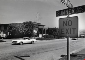
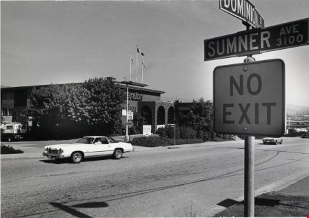
Sheraton Villa Inn
https://search.heritageburnaby.ca/link/archivedescription79334
- Repository
- City of Burnaby Archives
- Date
- September, 1976
- Collection/Fonds
- Burnaby Public Library Contemporary Visual Archive Project
- Description Level
- Item
- Physical Description
- 1 photograph : b&w ; 11 x 16 cm mounted on cardboard
- Scope and Content
- Photograph shows the Sheraton Villa Inn at 4330 Dominion Street near Sumner Avenue.
- Repository
- City of Burnaby Archives
- Date
- September, 1976
- Collection/Fonds
- Burnaby Public Library Contemporary Visual Archive Project
- Physical Description
- 1 photograph : b&w ; 11 x 16 cm mounted on cardboard
- Description Level
- Item
- Record No.
- 556-248
- Access Restriction
- No restrictions
- Reproduction Restriction
- Reproduce for fair dealing purposes only
- Accession Number
- 2013-13
- Scope and Content
- Photograph shows the Sheraton Villa Inn at 4330 Dominion Street near Sumner Avenue.
- Names
- Sheraton Villa Inn
- Media Type
- Photograph
- Photographer
- Cook, Alan
- Notes
- Scope note taken directly from BPL photograph description.
- 1 b&w copy negative : 10 x 12.5 cm accompanying
- Geographic Access
- Dominion Street
- Sumner Avenue
- Street Address
- 4330 Dominion Street
- Historic Neighbourhood
- Broadview (Historic Neighbourhood)
- Planning Study Area
- Cascade-Schou Area
Images
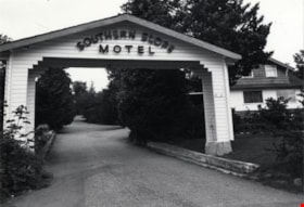
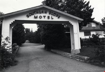
Southern Slope Motel
https://search.heritageburnaby.ca/link/archivedescription79335
- Repository
- City of Burnaby Archives
- Date
- September 10, 1976
- Collection/Fonds
- Burnaby Public Library Contemporary Visual Archive Project
- Description Level
- Item
- Physical Description
- 1 photograph : b&w ; 11 x 16 cm mounted on cardboard
- Scope and Content
- Photograph shows arch at entrance to Southern Slope Motel located at 4653 Marine Drive.
- Repository
- City of Burnaby Archives
- Date
- September 10, 1976
- Collection/Fonds
- Burnaby Public Library Contemporary Visual Archive Project
- Physical Description
- 1 photograph : b&w ; 11 x 16 cm mounted on cardboard
- Description Level
- Item
- Record No.
- 556-249
- Access Restriction
- No restrictions
- Reproduction Restriction
- Reproduce for fair dealing purposes only
- Accession Number
- 2013-13
- Scope and Content
- Photograph shows arch at entrance to Southern Slope Motel located at 4653 Marine Drive.
- Names
- Southern Slope Motel
- Media Type
- Photograph
- Photographer
- Ross, Martha
- Notes
- Scope note taken directly from BPL photograph description.
- 1 b&w copy negative : 10 x 12.5 cm accompanying
- Geographic Access
- Marine Drive
- Street Address
- 4653 Marine Drive
- Historic Neighbourhood
- Alta-Vista (Historic Neighbourhood)
- Planning Study Area
- Sussex-Nelson Area
Images
![Tom Irvine and friends, [between 1926 and 1930] thumbnail](/media/hpo/_Data/_BVM_Images/1974/197500330003ay.jpg?width=280)
Tom Irvine and friends
https://search.heritageburnaby.ca/link/museumdescription3534
- Repository
- Burnaby Village Museum
- Date
- [between 1926 and 1930]
- Collection/Fonds
- Burnaby Village Museum Photograph collection
- Description Level
- Item
- Physical Description
- 1 photograph : sepia ; 13.5 x 8 cm
- Scope and Content
- Photograph of two men standing on either side of a woman in front of the Central Hotel in White Rock, BC. There is an open touring car behind the people. Sign on the second floor of the hotel, in the background that reads: “CENTRAL HOTEL / MEALS / AND / ROOMS / S& P ELSEY PROPS”. There is another s…
- Repository
- Burnaby Village Museum
- Collection/Fonds
- Burnaby Village Museum Photograph collection
- Description Level
- Item
- Physical Description
- 1 photograph : sepia ; 13.5 x 8 cm
- Scope and Content
- Photograph of two men standing on either side of a woman in front of the Central Hotel in White Rock, BC. There is an open touring car behind the people. Sign on the second floor of the hotel, in the background that reads: “CENTRAL HOTEL / MEALS / AND / ROOMS / S& P ELSEY PROPS”. There is another sign directly behind the people. The first line of the sign reads: “_TAGE DEPOT” (STAGE DEPOT). Other signs on the front of the hotel read: “CENTRAL HOTEL DINING ROOM / AFTERNOON TEAS& REFRESHMENT” and “CENTRAL HOTEL”. There are two awnings with “CENTRAL HOTEL” on the front edges
- Accession Code
- HV975.33.3ay
- Access Restriction
- No restrictions
- Date
- [between 1926 and 1930]
- Media Type
- Photograph
- Scan Resolution
- 600
- Scan Date
- 2/2/2010
- Scale
- 100
- Notes
- Title based on contents of photograph
- For related images see: HV975.33.3ad
Images
![Tom Irvine and friends, [between 1926 and 1930] thumbnail](/media/hpo/_Data/_BVM_Images/1974/197500330003ay.jpg)
![Unidentified man at building site, [1938] thumbnail](/media/hpo/_Data/_Archives_Images/_Unrestricted/550/550-247.jpg?width=280)
Unidentified man at building site
https://search.heritageburnaby.ca/link/archivedescription82694
- Repository
- City of Burnaby Archives
- Date
- [1938]
- Collection/Fonds
- Hill family and Vidal family fonds
- Description Level
- Item
- Physical Description
- 1 photograph : b&w ; 6.5 x 10.5 cm
- Scope and Content
- Photograph shows an unidentified man standing beside a truck and the construction site of a building that is most likely Yellow Point Lodge.
- Repository
- City of Burnaby Archives
- Date
- [1938]
- Collection/Fonds
- Hill family and Vidal family fonds
- Physical Description
- 1 photograph : b&w ; 6.5 x 10.5 cm
- Description Level
- Item
- Record No.
- 550-247
- Access Restriction
- No restrictions
- Reproduction Restriction
- No known restrictions
- Accession Number
- 2013-03
- Scope and Content
- Photograph shows an unidentified man standing beside a truck and the construction site of a building that is most likely Yellow Point Lodge.
- Media Type
- Photograph
- Notes
- Title based on contents of photograph
Images
![Unidentified man at building site, [1938] thumbnail](/media/hpo/_Data/_Archives_Images/_Unrestricted/550/550-247.jpg)
Wigwam Inn
https://search.heritageburnaby.ca/link/archivedescription82513
- Repository
- City of Burnaby Archives
- Date
- 1918
- Collection/Fonds
- Hill family and Vidal family fonds
- Description Level
- Item
- Physical Description
- 1 photograph : sepia ; 5.5 x 7.5 cm
- Scope and Content
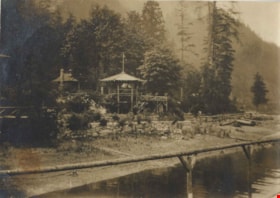
- Photograph shows a building surrounded by trees and mountains.
- Repository
- City of Burnaby Archives
- Date
- 1918
- Collection/Fonds
- Hill family and Vidal family fonds
- Physical Description
- 1 photograph : sepia ; 5.5 x 7.5 cm
- Description Level
- Item
- Record No.
- 550-087
- Access Restriction
- No restrictions
- Reproduction Restriction
- No known restrictions
- Accession Number
- 2013-03
- Scope and Content
- Photograph shows a building surrounded by trees and mountains.
- Media Type
- Photograph
- Notes
- Title based on note accompanying photograph
- Note in pencil on album page reads: "1918 / Wigwam Inn"
Images

Wigwam Inn
https://search.heritageburnaby.ca/link/archivedescription39237
- Repository
- City of Burnaby Archives
- Date
- 1923
- Collection/Fonds
- Peers Family and Hill Family fonds
- Description Level
- Item
- Physical Description
- 1 photograph : b&w ; 5.5 x 10 cm on page 24.5 x 32.5 cm (pasted in album)
- Scope and Content
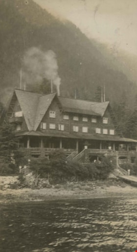
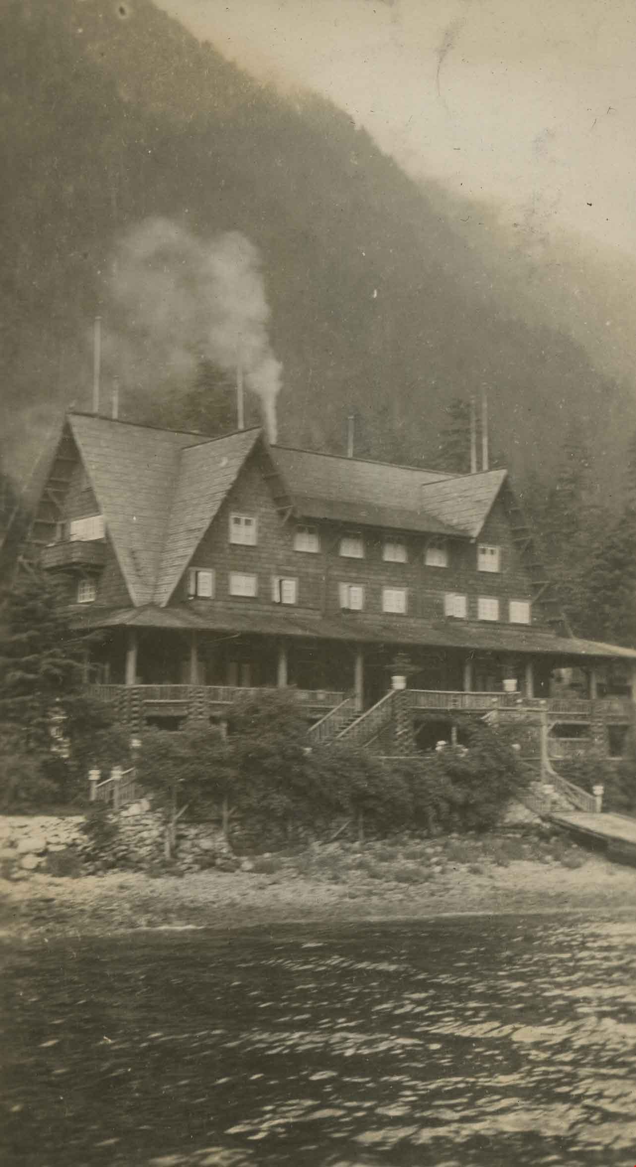
- Photograph of the Wigwam Inn, which is located at the northern end of Indian Arm of Burrard Inlet.
- Repository
- City of Burnaby Archives
- Date
- 1923
- Collection/Fonds
- Peers Family and Hill Family fonds
- Physical Description
- 1 photograph : b&w ; 5.5 x 10 cm on page 24.5 x 32.5 cm (pasted in album)
- Description Level
- Item
- Record No.
- 477-556
- Access Restriction
- No restrictions
- Reproduction Restriction
- No known restrictions
- Accession Number
- 2007-12
- Scope and Content
- Photograph of the Wigwam Inn, which is located at the northern end of Indian Arm of Burrard Inlet.
- Names
- Wigwam Inn
- Media Type
- Photograph
- Notes
- Title based on caption accompanying photograph
Images

Parkcrest Plaza
https://search.heritageburnaby.ca/link/archivedescription93653
- Repository
- City of Burnaby Archives
- Date
- October 23, 1977
- Collection/Fonds
- Burnaby Public Library Contemporary Visual Archive Project
- Description Level
- Item
- Physical Description
- 1 photograph : b&w ; 12.5 x 17.5 cm
- Scope and Content
- Photograph of the Parkcrest Plaza shopping centre at Sperling and Broadway. The photograph is taken from across the parking lot and lawn, facing west. Signs for the plaza's businesses include Fresh Foods and Bank of Nova Scotia, and homes and apartment buildings are in the distance.
- Repository
- City of Burnaby Archives
- Date
- October 23, 1977
- Collection/Fonds
- Burnaby Public Library Contemporary Visual Archive Project
- Physical Description
- 1 photograph : b&w ; 12.5 x 17.5 cm
- Description Level
- Item
- Record No.
- 556-610
- Access Restriction
- No restrictions
- Reproduction Restriction
- Reproduce for fair dealing purposes only
- Accession Number
- 2017-57
- Scope and Content
- Photograph of the Parkcrest Plaza shopping centre at Sperling and Broadway. The photograph is taken from across the parking lot and lawn, facing west. Signs for the plaza's businesses include Fresh Foods and Bank of Nova Scotia, and homes and apartment buildings are in the distance.
- Subjects
- Buildings - Commercial - Grocery Stores
- Buildings - Commercial - Malls
- Buildings - Commercial - Banks
- Buildings - Commercial - Stores
- Media Type
- Photograph
- Photographer
- Chapman, Fred
- Notes
- Title taken from project information form
- Accompanied by a project information form and 1 photograph (b&w negative ; 9.5 x 12.5 cm)
- BPL no. 60
- Geographic Access
- Sperling Avenue
- Broadway
- Street Address
- 5901 Sperling Avenue
- Planning Study Area
- Parkcrest-Aubrey Area
Images

7641-7651 Royal Oak Ave
https://search.heritageburnaby.ca/link/archivedescription93769
- Repository
- City of Burnaby Archives
- Date
- July 30, 1992
- Collection/Fonds
- Grover, Elliott & Co. Ltd. fonds
- Description Level
- File
- Physical Description
- 25 photographs : col. negatives ; 35 mm
- Scope and Content
- Photographs of the commercial properties located between 7641 and 7651 Royal Oak Avenue. Stores visible in the photographs include: Buy Low Foods, Mega Movies, and Chevron service station.
- Repository
- City of Burnaby Archives
- Date
- July 30, 1992
- Collection/Fonds
- Grover, Elliott & Co. Ltd. fonds
- Physical Description
- 25 photographs : col. negatives ; 35 mm
- Description Level
- File
- Record No.
- 622-053
- Access Restriction
- No restrictions
- Reproduction Restriction
- No restrictions
- Accession Number
- 2017-39
- Scope and Content
- Photographs of the commercial properties located between 7641 and 7651 Royal Oak Avenue. Stores visible in the photographs include: Buy Low Foods, Mega Movies, and Chevron service station.
- Subjects
- Buildings - Commercial
- Buildings - Commercial - Service Stations
- Buildings - Commercial - Stores
- Geographic Features - Roads
- Media Type
- Photograph
- Photographer
- Young, Richard
- Notes
- Transcribed title
- Title transcribed from envelope photographs were originally housed in
- File no. 92-287-B
- Geographic Access
- Royal Oak Avenue
- Historic Neighbourhood
- Alta Vista (Historic Neighbourhood)
- Planning Study Area
- Maywood Area

Bell's Dry Goods
https://search.heritageburnaby.ca/link/museumdescription14036
- Repository
- Burnaby Village Museum
- Date
- 11 Aug. 1994
- Collection/Fonds
- Burnaby Village Museum fonds
- Description Level
- Item
- Physical Description
- 1 videocassette (62 min., 50 sec.) : VHS, col., sd.
- Scope and Content
- Film footage of an interview conducted and recorded by Burnaby Village Museum curator Colin Stevens with Burnaby residents gathered inside of Bell's Dry Goods store on the site of Burnaby Village Museum. Burnaby residents were customers and friends of Mr. and Mrs. Bell and included: Jim Agnew; Mary…
- Repository
- Burnaby Village Museum
- Collection/Fonds
- Burnaby Village Museum fonds
- Subseries
- Bell's research files subseries
- Description Level
- Item
- Physical Description
- 1 videocassette (62 min., 50 sec.) : VHS, col., sd.
- Scope and Content
- Film footage of an interview conducted and recorded by Burnaby Village Museum curator Colin Stevens with Burnaby residents gathered inside of Bell's Dry Goods store on the site of Burnaby Village Museum. Burnaby residents were customers and friends of Mr. and Mrs. Bell and included: Jim Agnew; Mary Agne; May and Bill Long; Mel Coutts; Lois Coutts; Isobel Coutts and Aubrey Coutts. These residents all lived in the area of the building and knew the owners between 1920 and 1950. Residents recall the layout and furnishings of the interior of the building when it was operated as Bell's Dry Goods (1925 to 1937), Jean's Grocery Store [?], Whitechurch Hardware (1937-1973). Colin Stevens is particularly interested in gathering information on the layout and furnishings in Bell's since the museum intends to restore the building and display to the 1920s era.
- Creator
- Stevens, Colin
- Subjects
- Buildings - Commercial
- Buildings - Commercial - Grocery Stores
- Buildings - Commercial - Hardware Stores
- Names
- Agnew, Jim
- Agnew, Mary
- Coutts, Mel
- Coutts, Lois Hollands
- Coutts, Aubrey
- Coutts, Isobel
- Long, May Walker
- Long, Bill
- Stevens, Colin
- Accession Code
- BV020.5.737
- Access Restriction
- Restricted access
- Reproduction Restriction
- May be restricted by third party rights
- Date
- 11 Aug. 1994
- Media Type
- Moving Images
- Notes
- Title based on contents
- Label on videocassette reads: "Bells' Dry Goods" / "Interview with People / who used to shop there / at / "Bells' Dry Goods" / 6th St. Burnaby / 1994 Aug 11 Colin Stevens"
Images


Burnaby Place
https://search.heritageburnaby.ca/link/archivedescription93691
- Repository
- City of Burnaby Archives
- Date
- June 4, 1978
- Collection/Fonds
- Burnaby Public Library Contemporary Visual Archive Project
- Description Level
- Item
- Physical Description
- 1 photograph : b&w ; 12.5 x 17.5 cm
- Scope and Content
- Photograph of a commercial mid-rise building at Patterson Avenue and Kingsway, near Central Park. A Shell gas station is next to the building and a Bank of Nova Scotia occupies the first floor. The photograph is taken from Patterson, facing east on Kingsway. Pedestrians are crossing at the intersec…
- Repository
- City of Burnaby Archives
- Date
- June 4, 1978
- Collection/Fonds
- Burnaby Public Library Contemporary Visual Archive Project
- Physical Description
- 1 photograph : b&w ; 12.5 x 17.5 cm
- Description Level
- Item
- Record No.
- 556-648
- Access Restriction
- No restrictions
- Reproduction Restriction
- Reproduce for fair dealing purposes only
- Accession Number
- 2017-57
- Scope and Content
- Photograph of a commercial mid-rise building at Patterson Avenue and Kingsway, near Central Park. A Shell gas station is next to the building and a Bank of Nova Scotia occupies the first floor. The photograph is taken from Patterson, facing east on Kingsway. Pedestrians are crossing at the intersection.
- Subjects
- Buildings - Commercial
- Buildings - Commercial - Service Stations
- Buildings - Commercial - Banks
- Media Type
- Photograph
- Photographer
- Chapman, Fred
- Notes
- Title taken from project information form
- Accompanied by a project information form and 1 photograph (b&w negative ; 9.5 x 12.5 cm)
- BPL no. 96
- Geographic Access
- Kingsway
- Central Park
- Patterson Avenue
- Historic Neighbourhood
- Central Park (Historic Neighbourhood)
- Planning Study Area
- Maywood Area
Images

Interview with Cice Brown, May 13, 2005 - Track 2
https://search.heritageburnaby.ca/link/museumdescription4477
- Repository
- Burnaby Village Museum
- Date
- 1930-1949 (interview content), interviewed May 10, 2005
- Collection/Fonds
- Burnaby Village Museum fonds
- Description Level
- Item
- Physical Description
- 1 sound recording (mp3) (0:06:11 min)
- Scope and Content
- Track 2: This portion of the recording pertains to responsibilities, chores, and money. Cice recalls her chores, and how she spent her allowance. She describes her jobs in Mr. Pitman’s drygoods stores, on Kingsway and on Jubilee Ave., and in Anne Reid’s candy shop. Asked about church, Cice discuss…
- Repository
- Burnaby Village Museum
- Collection/Fonds
- Burnaby Village Museum fonds
- Series
- Museum Oral Histories series
- Subseries
- Growing Up in Burnaby subseries
- Description Level
- Item
- Physical Description
- 1 sound recording (mp3) (0:06:11 min)
- Material Details
- Interviewer: Tom Gooden Interviewee: Cice Brown Date of interview: May 13, 2005 Total Number of Tracks: 7 Total length of all Tracks: 0:40:19
- Scope and Content
- Track 2: This portion of the recording pertains to responsibilities, chores, and money. Cice recalls her chores, and how she spent her allowance. She describes her jobs in Mr. Pitman’s drygoods stores, on Kingsway and on Jubilee Ave., and in Anne Reid’s candy shop. Asked about church, Cice discusses her involvement with the Henderson-Jubilee United church, and C.G.I.T..
- History
- Recording of an interview with Cice Brown, interviewed by Tom Gooden on May 13 2005. This recording was completed for an exhibit, Growing Up in Burnaby, for the Burnaby Village Museum. Major themes discussed are growing up in Burnaby in the 1930s and 40s.
- Creator
- Burnaby Village Museum
- Subjects
- Buildings - Commercial - General Stores
- Buildings - Commercial - Grocery Stores
- Buildings - Commercial - Stores
- Names
- Brown, Cice Chandler
- Geographic Access
- Kingsway
- Jubilee Avenue
- Accession Code
- BV017.45.3
- Access Restriction
- No restrictions
- Date
- 1930-1949 (interview content), interviewed May 10, 2005
- Media Type
- Sound Recording
- Notes
- Title based on contents of item
Audio Tracks
Interview with Cice Brown, May 13, 2005 - Track 2, 1930-1949 (interview content), interviewed May 10, 2005
Interview with Cice Brown, May 13, 2005 - Track 2, 1930-1949 (interview content), interviewed May 10, 2005
https://search.heritageburnaby.ca/media/hpo/_Data/_BVM_Sound_Recordings/Oral_Histories/2017_0045_0003_002.mp3Interview with Janet White May 10, 2005 - Track 2
https://search.heritageburnaby.ca/link/museumdescription4468
- Repository
- Burnaby Village Museum
- Date
- [195-] (interview content), interviewed May 10, 2005
- Collection/Fonds
- Burnaby Village Museum fonds
- Description Level
- Item
- Physical Description
- 1 sound recording (mp3) (0:04:14 min)
- Scope and Content
- Track 2: This portion of the recording pertains to childhood responsibilities, chores, and early jobs, and the growth of Burnaby as experienced by a child. Janet describes her chores, and her first jobs at the PNE, Sears, and Super Value. She discusses how she used her allowance and employment inco…
- Repository
- Burnaby Village Museum
- Collection/Fonds
- Burnaby Village Museum fonds
- Series
- Museum Oral Histories series
- Subseries
- Growing Up in Burnaby subseries
- Description Level
- Item
- Physical Description
- 1 sound recording (mp3) (0:04:14 min)
- Material Details
- Interviewer: Tom Gooden Interviewee: Janet White Date of interview: May 10, 2005 Total Number of Tracks: 8 Total length of all Tracks: 0:31:34
- Scope and Content
- Track 2: This portion of the recording pertains to childhood responsibilities, chores, and early jobs, and the growth of Burnaby as experienced by a child. Janet describes her chores, and her first jobs at the PNE, Sears, and Super Value. She discusses how she used her allowance and employment incomes.
- History
- Recording of an interview with Janet White recording by Tom Gooden on May 10 2005. This recording was completed for an exhibit, Growing Up in Burnaby, for the Burnaby Village Museum. Major themes discussed are growing up in Burnaby in the 1950s.
- Creator
- Burnaby Village Museum
- Subjects
- Buildings - Commercial
- Buildings - Commercial - Grocery Stores
- Buildings - Commercial - Stores
- Names
- Gooden, Tom
- White, Janet
- Accession Code
- BV017.45.1
- Access Restriction
- No restrictions
- Reproduction Restriction
- May be restricted by third party rights
- Date
- [195-] (interview content), interviewed May 10, 2005
- Media Type
- Sound Recording
Audio Tracks
Interview with Janet White May 10, 2005 - Track 2, [195-] (interview content), interviewed May 10, 2005
Interview with Janet White May 10, 2005 - Track 2, [195-] (interview content), interviewed May 10, 2005
https://search.heritageburnaby.ca/media/hpo/_Data/_BVM_Sound_Recordings/Oral_Histories/2017_0045_0001_002.mp3
Oh! Zhhu Sam
https://search.heritageburnaby.ca/link/archivedescription98681
- Repository
- City of Burnaby Archives
- Date
- 2022
- Collection/Fonds
- Disappearing Burnaby collection
- Description Level
- Item
- Physical Description
- 1 photograph (jpeg) : col.
- Scope and Content
- Photograph of the 7500 block of Edmonds Street at dusk. The photograph is taken from across Edmonds Street and depicts two commercial buildings: Oh! Zzhu Sam Korean Restaurant and the European Butcher Boy Delicatessen & Grocery. Oh! Zzhu Sam, located at 7506 Edmonds Street, was constructed in 1976.…
- Repository
- City of Burnaby Archives
- Date
- 2022
- Collection/Fonds
- Disappearing Burnaby collection
- Physical Description
- 1 photograph (jpeg) : col.
- Description Level
- Item
- Record No.
- 634-028
- Access Restriction
- No restrictions
- Reproduction Restriction
- No restrictions
- Accession Number
- 2022-14
- Scope and Content
- Photograph of the 7500 block of Edmonds Street at dusk. The photograph is taken from across Edmonds Street and depicts two commercial buildings: Oh! Zzhu Sam Korean Restaurant and the European Butcher Boy Delicatessen & Grocery. Oh! Zzhu Sam, located at 7506 Edmonds Street, was constructed in 1976. Residential houses border the restaurant and grocery store, and a bus shelter, municipal garbage can, and the restaurant's illuminated neon sign stand in front of the buildings.
- Subjects
- Buildings - Commercial
- Buildings - Commercial - Grocery Stores
- Buildings - Commercial - Restaurants
- Media Type
- Photograph
- Photographer
- Cheung, Nakita
- Notes
- Title taken from the associated blog post
- Associated blog post: https://disappearingburnaby.wordpress.com/2022/07/29/oh-zzhu-sam/
- Geographic Access
- Edmonds Street
- Street Address
- 7506 Edmonds Street
- Historic Neighbourhood
- Edmonds (Historic Neighbourhood)
- Planning Study Area
- Edmonds Area
Images


Trafalgar Market
https://search.heritageburnaby.ca/link/archivedescription98665
- Repository
- City of Burnaby Archives
- Date
- 2022
- Collection/Fonds
- Disappearing Burnaby collection
- Description Level
- Item
- Physical Description
- 1 photograph (jpeg) : col.
- Scope and Content
- Photograph of the intersection of Imperial Street and Sussex Avenue at night and in the rain. The photograph shows the Trafalgar Market grocery store (located at 4398 Imperial Street; the building was constructed in 1940) on the corner, with a large display of flowers for sale under the awning in f…
- Repository
- City of Burnaby Archives
- Date
- 2022
- Collection/Fonds
- Disappearing Burnaby collection
- Physical Description
- 1 photograph (jpeg) : col.
- Description Level
- Item
- Record No.
- 634-012
- Access Restriction
- No restrictions
- Reproduction Restriction
- No restrictions
- Accession Number
- 2022-14
- Scope and Content
- Photograph of the intersection of Imperial Street and Sussex Avenue at night and in the rain. The photograph shows the Trafalgar Market grocery store (located at 4398 Imperial Street; the building was constructed in 1940) on the corner, with a large display of flowers for sale under the awning in front of the store. The street and traffic lights are reflected in the puddles on the road, and cars and other businesses are visible along Imperial Street.
- Subjects
- Buildings - Commercial
- Buildings - Commercial - Grocery Stores
- Buildings - Commercial - Stores
- Geographic Features - Roads
- Media Type
- Photograph
- Photographer
- Cheung, Nakita
- Notes
- Title taken from the associated blog post
- Associated blog post: https://disappearingburnaby.wordpress.com/2022/02/20/imperial-manor-2/
- Geographic Access
- Imperial Street
- Sussex Avenue
- Street Address
- 4398 Imperial Street
- Historic Neighbourhood
- Central Park (Historic Neighbourhood)
- Planning Study Area
- Sussex-Nelson Area
Images
