More like 'Alfred Bingham's writings - Track 1'
Narrow Results By
Subject
- Accidents 1
- Accidents - Automobile Accidents
- Advertising Medium 2
- Advertising Medium - Signs and Signboards 41
- Aerial Photographs
- Agricultural Tools and Equipment 2
- Agricultural Tools and Equipment - Gardening Equipment 4
- Agricultural Tools and Equipment - Plows 2
- Agriculture 3
- Agriculture - Farms
- Agriculture - Fruit and Berries 3
- Animals 4
![Burnaby Mountain, [between 1958 and 1965] (date of original), copied 1991 thumbnail](/media/hpo/_Data/_Archives_Images/_Unrestricted/370/370-797.jpg?width=280)
Burnaby Mountain
https://search.heritageburnaby.ca/link/archivedescription38210
- Repository
- City of Burnaby Archives
- Date
- [between 1958 and 1965] (date of original), copied 1991
- Collection/Fonds
- Burnaby Historical Society fonds
- Description Level
- Item
- Physical Description
- 1 photograph : b&w ; 3.2 x 5.1 cm print on contact sheet 20.5 x 26.8 cm
- Scope and Content
- Aerial photograph of Centennial Park, Burnaby Mountain and Burrard Inlet looking east.
- Repository
- City of Burnaby Archives
- Date
- [between 1958 and 1965] (date of original), copied 1991
- Collection/Fonds
- Burnaby Historical Society fonds
- Subseries
- Burnaby Image Bank subseries
- Physical Description
- 1 photograph : b&w ; 3.2 x 5.1 cm print on contact sheet 20.5 x 26.8 cm
- Description Level
- Item
- Record No.
- 370-797
- Access Restriction
- No restrictions
- Reproduction Restriction
- No restrictions
- Accession Number
- BHS1999-03
- Scope and Content
- Aerial photograph of Centennial Park, Burnaby Mountain and Burrard Inlet looking east.
- Subjects
- Aerial Photographs
- Geographic Features - Inlets
- Geographic Features - Mountains
- Geographic Features - Parks
- Media Type
- Photograph
- Notes
- Title based on contents of photograph
- 1 b&w copy negative accompanying
- Geographic Access
- Burnaby Mountain Conservation Area
- Planning Study Area
- Burnaby Mountain Area
Images
![Burnaby Mountain, [between 1958 and 1965] (date of original), copied 1991 thumbnail](/media/hpo/_Data/_Archives_Images/_Unrestricted/370/370-797.jpg)
![Kingsway and Central Park, [196-] thumbnail](/media/hpo/_Data/_Archives_Images/_Unrestricted/001/083-001.jpg?width=280)
Kingsway and Central Park
https://search.heritageburnaby.ca/link/archivedescription34658
- Repository
- City of Burnaby Archives
- Date
- [196-]
- Collection/Fonds
- Burnaby Historical Society fonds
- Description Level
- Item
- Physical Description
- 1 photograph : b&w ; 14.5 x 19.4 cm
- Scope and Content
- Aerial photograph of Kingsway and Central Park.
- Repository
- City of Burnaby Archives
- Date
- [196-]
- Collection/Fonds
- Burnaby Historical Society fonds
- Subseries
- Photographs subseries
- Physical Description
- 1 photograph : b&w ; 14.5 x 19.4 cm
- Description Level
- Item
- Record No.
- 083-001
- Access Restriction
- No restrictions
- Reproduction Restriction
- Reproduce for fair dealing purposes only
- Accession Number
- BHS2007-04
- Scope and Content
- Aerial photograph of Kingsway and Central Park.
- Media Type
- Photograph
- Notes
- Title based on contents of photograph
- Geographic Access
- Kingsway
- Central Park
- Historic Neighbourhood
- Central Park (Historic Neighbourhood)
- Planning Study Area
- Maywood Area
Images
![Kingsway and Central Park, [196-] thumbnail](/media/hpo/_Data/_Archives_Images/_Unrestricted/001/083-001.jpg)
![Lower Mainland, [1946] thumbnail](/media/hpo/_Data/_Archives_Images/_Unrestricted/485/486-039.jpg?width=280)
Lower Mainland
https://search.heritageburnaby.ca/link/archivedescription55645
- Repository
- City of Burnaby Archives
- Date
- [1946]
- Collection/Fonds
- Charles MacSorley fonds
- Description Level
- Item
- Physical Description
- 1 photograph : b&w ; 20.5 x 25.5 cm
- Scope and Content
- Aerial photograph of the Lower Mainland of British Columbia, looking east over Stanley Park and the Burrard Inlet. A printed description accompanying the photograph reads: "A view of the Lower Mainland taken along Burrard Inlet. The block of land in the lower centre of the photograph is Stanley Par…
- Repository
- City of Burnaby Archives
- Date
- [1946]
- Collection/Fonds
- Charles MacSorley fonds
- Physical Description
- 1 photograph : b&w ; 20.5 x 25.5 cm
- Description Level
- Item
- Record No.
- 486-039
- Access Restriction
- No restrictions
- Reproduction Restriction
- No known restrictions
- Accession Number
- 2005-14
- Scope and Content
- Aerial photograph of the Lower Mainland of British Columbia, looking east over Stanley Park and the Burrard Inlet. A printed description accompanying the photograph reads: "A view of the Lower Mainland taken along Burrard Inlet. The block of land in the lower centre of the photograph is Stanley Park with the business section of the City of Vancouver connected thereto. To the left of the Inlet is the City and District of North Vancouver and just above Vancouver is the District of Burnaby. The mountains at the extreme top of the photograph are the Coastal Range and are over a hundred miles away. The mountains to the left can be reached by a fifteen-minute drive from the city. Presented with the compliments of the Corporation of the District of Burnaby."
- Media Type
- Photograph
- Notes
- Title based on caption
- Caption on recto reads: "Lower Mainland"
- Printed description adhered to verso of photograph
Images
![Lower Mainland, [1946] thumbnail](/media/hpo/_Data/_Archives_Images/_Unrestricted/485/486-039.jpg)
![Aerial photograph of Burnaby Mountain, [1957 or 1958] thumbnail](/media/hpo/_Data/_Archives_Images/_Unrestricted/371/476-025.jpg?width=280)
Aerial photograph of Burnaby Mountain
https://search.heritageburnaby.ca/link/archivedescription39742
- Repository
- City of Burnaby Archives
- Date
- [1957 or 1958]
- Collection/Fonds
- Burnaby Historical Society fonds
- Description Level
- Item
- Physical Description
- 1 photograph : b&w ; 14 x 14 cm
- Scope and Content
- Aerial photograph of the Burnaby Mountain park and Centennial Pavilion, under construction.
- Repository
- City of Burnaby Archives
- Date
- [1957 or 1958]
- Collection/Fonds
- Burnaby Historical Society fonds
- Subseries
- North Burnaby Board of Trade subseries
- Physical Description
- 1 photograph : b&w ; 14 x 14 cm
- Description Level
- Item
- Record No.
- 476-025
- Access Restriction
- No restrictions
- Reproduction Restriction
- Reproduce for fair dealing purposes only
- Accession Number
- BHS2005-8
- Scope and Content
- Aerial photograph of the Burnaby Mountain park and Centennial Pavilion, under construction.
- Subjects
- Aerial Photographs
- Land Clearing
- Media Type
- Photograph
- Photographer
- Hunting Survey Corporation Limited
- Notes
- Title based on contents of photograph.
- Geographic Access
- Burnaby Mountain Conservation Area
- Centennial Way
- Street Address
- 100 Centennial Way
- Planning Study Area
- Burnaby Mountain Area
Images
![Aerial photograph of Burnaby Mountain, [1957 or 1958] thumbnail](/media/hpo/_Data/_Archives_Images/_Unrestricted/371/476-025.jpg)
Aerial photograph of Burnaby Mountain
https://search.heritageburnaby.ca/link/archivedescription64460
- Repository
- City of Burnaby Archives
- Date
- [1957 or 1958]
- Collection/Fonds
- Burnaby Historical Society fonds
- Description Level
- Item
- Physical Description
- 1 photograph : b&w ; 14 x 14 cm
- Scope and Content
- Aerial photograph of the Burnaby Mountain park and Centennial Pavilion, under construction.
- Repository
- City of Burnaby Archives
- Date
- [1957 or 1958]
- Collection/Fonds
- Burnaby Historical Society fonds
- Subseries
- North Burnaby Board of Trade subseries
- Physical Description
- 1 photograph : b&w ; 14 x 14 cm
- Description Level
- Item
- Record No.
- 476-026
- Access Restriction
- No restrictions
- Reproduction Restriction
- Reproduce for fair dealing purposes only
- Accession Number
- BHS2005-8
- Scope and Content
- Aerial photograph of the Burnaby Mountain park and Centennial Pavilion, under construction.
- Subjects
- Aerial Photographs
- Land Clearing
- Media Type
- Photograph
- Photographer
- Hunting Survey Corporation Limited
- Notes
- Title based on contents of photograph
- Geographic Access
- Burnaby Mountain Conservation Area
- Centennial Way
- Street Address
- 100 Centennial Way
- Planning Study Area
- Burnaby Mountain Area
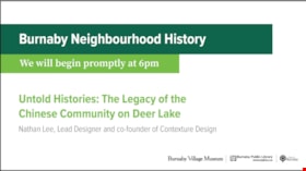
Untold Histories: The Legacy of the Chinese Community on Deer Lake
https://search.heritageburnaby.ca/link/museumdescription14758
- Repository
- Burnaby Village Museum
- Date
- 8 Oct. 2020
- Collection/Fonds
- Burnaby Village Museum fonds
- Description Level
- Item
- Physical Description
- 1 video recording (mp4) (56 min., 15 sec.) : digital, col., sd., stereo ; 29 fps
- Scope and Content
- Item consists of a video recording of a live Zoom webinar hosted by Burnaby Public Librarian, Mariah Gastaldo. The webinar is titled "Untold Histories: The Legacy of the Chinese Community on Deer Lake" and is presented by Nathan Lee, Lead Designer and co-founder of Contexture Design. The zoom webin…
- Repository
- Burnaby Village Museum
- Collection/Fonds
- Burnaby Village Museum fonds
- Description Level
- Item
- Physical Description
- 1 video recording (mp4) (56 min., 15 sec.) : digital, col., sd., stereo ; 29 fps
- Material Details
- Presenter: Nathan Lee
- Host: Mariah Gastaldo
- Date of Presentation: October 8, 6:00 pm - 8:00 pm
- Total Number of tracks: 1
- Total Length of all tracks: 56 min., 15 sec.
- Recording Device: Zoom video communication platform
- Scope and Content
- Item consists of a video recording of a live Zoom webinar hosted by Burnaby Public Librarian, Mariah Gastaldo. The webinar is titled "Untold Histories: The Legacy of the Chinese Community on Deer Lake" and is presented by Nathan Lee, Lead Designer and co-founder of Contexture Design. The zoom webinar is the third in a collection of seven "Burnaby Neighbourhood Speaker series" webinars that were presented and made available to the public between September 29 and October 27, 2020. The live webinar and recording was also made available on the Burnaby Village Museum's facebook page. In this webinar, Nathan Lee speaks about his public art installation that will be installed near the site of the Burnaby Art Gallery in Deer Lake Park. Nathan presents his background research which lead to the project. He tells how the site of the Burnaby Art Gallery and surrounding Century Garden are rich with stories of early settlers and of how British farmers and social elite have shaped the history of this area since the early 1900’s. Nathan's presentation highlights the unseen presence of a Chinese community that is equally profound in its connect. The presentation is supported with slides consisting of historical and contemporary photographs. At the conclusion of his presentation, Nathan takes questions from webinar participants.
- Subjects
- Persons - Chinese Canadians
- Arts - Sculptures
- Geographic Features - Parks
- Agriculture - Farms
- Geographic Access
- Deer Lake Avenue
- Deer Lake
- Deer Lake Park
- Accession Code
- BV020.29.3
- Access Restriction
- No restrictions
- Reproduction Restriction
- No known restrictions
- Date
- 8 Oct. 2020
- Media Type
- Moving Images
- Historic Neighbourhood
- Burnaby Lake (Historic Neighbourhood)
- Notes
- Title based on contents of video recording
- Video recording was edited for publication on Heritage Burnaby. Original mp4 video recording (BV020.29.3.1) is 66 min., 51 sec.
Images

Video
Untold Histories: The Legacy of the Chinese Community on Deer Lake, 8 Oct. 2020
Untold Histories: The Legacy of the Chinese Community on Deer Lake, 8 Oct. 2020
https://search.heritageburnaby.ca/media/hpo/_Data/_BVM_Moving_Images/2020_0029_0003_002.mp4
Construction of dykes on Nicomen Island
https://search.heritageburnaby.ca/link/archivedescription34330
- Repository
- City of Burnaby Archives
- Date
- 1927
- Collection/Fonds
- Burnaby Historical Society fonds
- Description Level
- Item
- Physical Description
- 1 photograph : sepia ; 5 x 13.5 cm on page 17.5 x 22.7 cm
- Scope and Content
- Photograph of a farm and field along the Fraser River next to dykes that are being built on Nicomen Island.
- Repository
- City of Burnaby Archives
- Date
- 1927
- Collection/Fonds
- Burnaby Historical Society fonds
- Subseries
- Peers family subseries
- Physical Description
- 1 photograph : sepia ; 5 x 13.5 cm on page 17.5 x 22.7 cm
- Description Level
- Item
- Record No.
- 020-037
- Access Restriction
- No restrictions
- Reproduction Restriction
- No known restrictions
- Accession Number
- BHS2007-04
- Scope and Content
- Photograph of a farm and field along the Fraser River next to dykes that are being built on Nicomen Island.
- Media Type
- Photograph
- Notes
- Title based on caption accompanying photograph
Images

![North Burnaby, [1959] thumbnail](/media/hpo/_Data/_Archives_Images/_Unrestricted/001/106-001.jpg?width=280)
North Burnaby
https://search.heritageburnaby.ca/link/archivedescription34701
- Repository
- City of Burnaby Archives
- Date
- [1959]
- Collection/Fonds
- Burnaby Historical Society fonds
- Description Level
- Item
- Physical Description
- 1 photograph : b&w ; 16.6 x 20.5 cm
- Scope and Content
- Aerial photograph of North Burnaby and Burrard Inlet looking west.
- Repository
- City of Burnaby Archives
- Date
- [1959]
- Collection/Fonds
- Burnaby Historical Society fonds
- Subseries
- Photographs subseries
- Physical Description
- 1 photograph : b&w ; 16.6 x 20.5 cm
- Description Level
- Item
- Record No.
- 106-001
- Access Restriction
- No restrictions
- Reproduction Restriction
- Reproduce for fair dealing purposes only
- Accession Number
- BHS2007-04
- Scope and Content
- Aerial photograph of North Burnaby and Burrard Inlet looking west.
- Media Type
- Photograph
- Notes
- Title based on contents of photograph
- Historic Neighbourhood
- Vancouver Heights (Historic Neighbourhood)
- Capitol Hill (Historic Neighbourhood)
- Lochdale (Historic Neighbourhood)
- Planning Study Area
- Burnaby Heights Area
- Capitol Hill Area
- Westridge Area
- Willingdon Heights Area
- Brentwood Area
- Parkcrest-Aubrey Area
- Lochdale Area
Images
![North Burnaby, [1959] thumbnail](/media/hpo/_Data/_Archives_Images/_Unrestricted/001/106-001.jpg)
Aerial photograph of Burnaby
https://search.heritageburnaby.ca/link/archivedescription84891
- Repository
- City of Burnaby Archives
- Date
- 1963
- Collection/Fonds
- Allan Amundsen collection
- Description Level
- Item
- Physical Description
- 1 photograph : b&w ; 22.5 x 22.5 cm
- Scope and Content
- Aerial photograph of Burnaby north of Lougheed Highway.
- Repository
- City of Burnaby Archives
- Date
- 1963
- Collection/Fonds
- Allan Amundsen collection
- Physical Description
- 1 photograph : b&w ; 22.5 x 22.5 cm
- Description Level
- Item
- Record No.
- 561-012
- Access Restriction
- In Archives only
- Reproduction Restriction
- No reproduction permitted
- Accession Number
- 2014-08
- Scope and Content
- Aerial photograph of Burnaby north of Lougheed Highway.
- Media Type
- Photograph
- Photographer
- Province of British Columbia
- Notes
- Title based on contents of photograph
- This photo is indentified as BC5061:117 and connects with B.C. air photograph BC5061:118 to the east
- Historic Neighbourhood
- Burnaby Lake (Historic Neighbourhood)
- Planning Study Area
- Parkcrest-Aubrey Area
- Ardingley-Sprott Area
Aerial photograph of Burnaby Mountain
https://search.heritageburnaby.ca/link/archivedescription84882
- Repository
- City of Burnaby Archives
- Date
- 1963
- Collection/Fonds
- Allan Amundsen collection
- Description Level
- Item
- Physical Description
- 1 photograph : b&w ; 22.5 x 22.5 cm
- Scope and Content
- Aerial photograph of Burnaby Mountain and surrounding area with Burrard Inlet to the north.
- Repository
- City of Burnaby Archives
- Date
- 1963
- Collection/Fonds
- Allan Amundsen collection
- Physical Description
- 1 photograph : b&w ; 22.5 x 22.5 cm
- Description Level
- Item
- Record No.
- 561-003
- Access Restriction
- In Archives only
- Reproduction Restriction
- No reproduction permitted
- Accession Number
- 2014-08
- Scope and Content
- Aerial photograph of Burnaby Mountain and surrounding area with Burrard Inlet to the north.
- Media Type
- Photograph
- Photographer
- Province of British Columbia
- Notes
- Title based on contents of photograph
- This photo is indentified as BC5061:83 and connects with B.C. air photograph BC5061:84 to the west and BC5061:82 to the east
- Geographic Access
- Burrard Inlet
- Burnaby Mountain Conservation Area
- Historic Neighbourhood
- Barnet (Historic Neighbourhood)
- Lochdale (Historic Neighbourhood)
- Planning Study Area
- Westridge Area
- Burnaby Mountain Area
- Lake City Area
Aerial photograph of Burnaby Mountain
https://search.heritageburnaby.ca/link/archivedescription84883
- Repository
- City of Burnaby Archives
- Date
- 1963
- Collection/Fonds
- Allan Amundsen collection
- Description Level
- Item
- Physical Description
- 1 photograph : b&w ; 22.5 x 22.5 cm
- Scope and Content
- Aerial photograph of Burnaby Mountain and surrounding area with Burrard Inlet to the north.
- Repository
- City of Burnaby Archives
- Date
- 1963
- Collection/Fonds
- Allan Amundsen collection
- Physical Description
- 1 photograph : b&w ; 22.5 x 22.5 cm
- Description Level
- Item
- Record No.
- 561-004
- Access Restriction
- In Archives only
- Reproduction Restriction
- No reproduction permitted
- Accession Number
- 2014-08
- Scope and Content
- Aerial photograph of Burnaby Mountain and surrounding area with Burrard Inlet to the north.
- Media Type
- Photograph
- Photographer
- Province of British Columbia
- Notes
- Title based on contents of photograph
- This photo is indentified as BC5061:82 and connects with B.C. air photograph BC5061:83 to the west and BC5061:81 to the east.
- Geographic Access
- Burrard Inlet
- Burnaby Mountain Conservation Area
- Historic Neighbourhood
- Barnet (Historic Neighbourhood)
- Planning Study Area
- Burnaby Mountain Area
- Lake City Area
Aerial photograph of Burnaby Mountain
https://search.heritageburnaby.ca/link/archivedescription84884
- Repository
- City of Burnaby Archives
- Date
- 1963
- Collection/Fonds
- Allan Amundsen collection
- Description Level
- Item
- Physical Description
- 1 photograph : b&w ; 22.5 x 22.5 cm
- Scope and Content
- Aerial photograph of Burnaby Mountain and surrounding area with Burrard Inlet to the north.
- Repository
- City of Burnaby Archives
- Date
- 1963
- Collection/Fonds
- Allan Amundsen collection
- Physical Description
- 1 photograph : b&w ; 22.5 x 22.5 cm
- Description Level
- Item
- Record No.
- 561-005
- Access Restriction
- In Archives only
- Reproduction Restriction
- No reproduction permitted
- Accession Number
- 2014-08
- Scope and Content
- Aerial photograph of Burnaby Mountain and surrounding area with Burrard Inlet to the north.
- Media Type
- Photograph
- Photographer
- Province of British Columbia
- Notes
- Title based on contents of photograph
- This photo is indentified as BC5061:81 and connects with B.C. air photograph BC5061:82 to the west and BC5061:80 to the east.
- Geographic Access
- Burrard Inlet
- Burnaby Mountain Conservation Area
- Historic Neighbourhood
- Barnet (Historic Neighbourhood)
- Planning Study Area
- Burnaby Mountain Area
Aerial photograph of Burnaby Mountain and Port Moody
https://search.heritageburnaby.ca/link/archivedescription84885
- Repository
- City of Burnaby Archives
- Date
- 1963
- Collection/Fonds
- Allan Amundsen collection
- Description Level
- Item
- Physical Description
- 1 photograph : b&w ; 22.5 x 22.5 cm
- Scope and Content
- Aerial photograph of Burnaby Mountain to the west, Burrard Inlet to the north and Port Moody to the east.
- Repository
- City of Burnaby Archives
- Date
- 1963
- Collection/Fonds
- Allan Amundsen collection
- Physical Description
- 1 photograph : b&w ; 22.5 x 22.5 cm
- Description Level
- Item
- Record No.
- 561-006
- Access Restriction
- In Archives only
- Reproduction Restriction
- No reproduction permitted
- Accession Number
- 2014-08
- Scope and Content
- Aerial photograph of Burnaby Mountain to the west, Burrard Inlet to the north and Port Moody to the east.
- Media Type
- Photograph
- Photographer
- Province of British Columbia
- Notes
- Title based on contents of photograph
- This photo is indentified as BC5061:80 and connects with B.C. air photograph BC5061:81 to the west and BC5061:79 to the east.
- Geographic Access
- Burrard Inlet
- Burnaby Mountain Conservation Area
- Historic Neighbourhood
- Barnet (Historic Neighbourhood)
- Planning Study Area
- Burnaby Mountain Area
Aerial photograph of Burrard Inlet
https://search.heritageburnaby.ca/link/archivedescription84888
- Repository
- City of Burnaby Archives
- Date
- 1963
- Collection/Fonds
- Allan Amundsen collection
- Description Level
- Item
- Physical Description
- 1 photograph : b&w ; 22.5 x 22.5 cm
- Scope and Content
- Aerial photograph of Burrard Inlet and Port Moody.
- Repository
- City of Burnaby Archives
- Date
- 1963
- Collection/Fonds
- Allan Amundsen collection
- Physical Description
- 1 photograph : b&w ; 22.5 x 22.5 cm
- Description Level
- Item
- Record No.
- 561-009
- Access Restriction
- In Archives only
- Reproduction Restriction
- No reproduction permitted
- Accession Number
- 2014-08
- Scope and Content
- Aerial photograph of Burrard Inlet and Port Moody.
- Media Type
- Photograph
- Photographer
- Province of British Columbia
- Notes
- Title based on contents of photograph
- This photo is indentified as BC5061:77 and connects with B.C. air photograph BC5061:78 to the west and BC5061:76 to the east
- Geographic Access
- Burrard Inlet
Aerial photograph of Coquitlam
https://search.heritageburnaby.ca/link/archivedescription84890
- Repository
- City of Burnaby Archives
- Date
- 1963
- Collection/Fonds
- Allan Amundsen collection
- Description Level
- Item
- Physical Description
- 1 photograph : b&w ; 22.5 x 22.5 cm
- Scope and Content
- Aerial photograph of Coquitlam with Burrard Inlet on the western edge of the image.
- Repository
- City of Burnaby Archives
- Date
- 1963
- Collection/Fonds
- Allan Amundsen collection
- Physical Description
- 1 photograph : b&w ; 22.5 x 22.5 cm
- Description Level
- Item
- Record No.
- 561-011
- Access Restriction
- In Archives only
- Reproduction Restriction
- No reproduction permitted
- Accession Number
- 2014-08
- Scope and Content
- Aerial photograph of Coquitlam with Burrard Inlet on the western edge of the image.
- Media Type
- Photograph
- Photographer
- Province of British Columbia
- Notes
- Title based on contents of photograph
- This photo is identified as BC5061:75 and connects with B.C. air photograph BC5061:76 to the west
Aerial photograph of North Burnaby
https://search.heritageburnaby.ca/link/archivedescription84881
- Repository
- City of Burnaby Archives
- Date
- 1963
- Collection/Fonds
- Allan Amundsen collection
- Description Level
- Item
- Physical Description
- 1 photograph : b&w ; 22.5 x 22.5 cm
- Scope and Content
- Aerial photograph of North Burnaby with Burrard Inlet to the north and Hastings Street, Inlet Drive, Barnet Road.
- Repository
- City of Burnaby Archives
- Date
- 1963
- Collection/Fonds
- Allan Amundsen collection
- Physical Description
- 1 photograph : b&w ; 22.5 x 22.5 cm
- Description Level
- Item
- Record No.
- 561-002
- Access Restriction
- In Archives only
- Reproduction Restriction
- No reproduction permitted
- Accession Number
- 2014-08
- Scope and Content
- Aerial photograph of North Burnaby with Burrard Inlet to the north and Hastings Street, Inlet Drive, Barnet Road.
- Media Type
- Photograph
- Photographer
- Province of British Columbia
- Notes
- Title based on contents of photograph
- This photo is indentified as BC5061:84 and connects with B.C. air photograph BC5061:85 to the west and BC5061:83 to the east
- Geographic Access
- Burrard Inlet
- Burnaby Mountain Conservation Area
- Historic Neighbourhood
- Capitol Hill (Historic Neighbourhood)
- Lochdale (Historic Neighbourhood)
- Planning Study Area
- Parkcrest-Aubrey Area
- Westridge Area
Aerial photograph of North Burnaby
https://search.heritageburnaby.ca/link/archivedescription93598
- Repository
- City of Burnaby Archives
- Date
- 1963
- Collection/Fonds
- Allan Amundsen collection
- Description Level
- Item
- Physical Description
- 1 photograph : b&w ; 22.5 x 22.5 cm
- Scope and Content
- Aerial photograph of North Burnaby with Burrard Inlet to the north and Hastings Street, Inlet Drive, Barnet Road.
- Repository
- City of Burnaby Archives
- Date
- 1963
- Collection/Fonds
- Allan Amundsen collection
- Physical Description
- 1 photograph : b&w ; 22.5 x 22.5 cm
- Description Level
- Item
- Record No.
- 561-001
- Access Restriction
- In Archives only
- Reproduction Restriction
- No reproduction permitted
- Accession Number
- 2014-08
- Scope and Content
- Aerial photograph of North Burnaby with Burrard Inlet to the north and Hastings Street, Inlet Drive, Barnet Road.
- Media Type
- Photograph
- Photographer
- Province of British Columbia
- Notes
- Title based on contents of photograph
- This photo is identified as BC5061:85
- Geographic Access
- Burrard Inlet
- Burnaby Mountain Conservation Area
- Historic Neighbourhood
- Capitol Hill (Historic Neighbourhood)
- Lochdale (Historic Neighbourhood)
- Planning Study Area
- Parkcrest-Aubrey Area
- Westridge Area
Aerial photograph of Port Moody
https://search.heritageburnaby.ca/link/archivedescription84886
- Repository
- City of Burnaby Archives
- Date
- 1963
- Collection/Fonds
- Allan Amundsen collection
- Description Level
- Item
- Physical Description
- 1 photograph : b&w ; 22.5 x 22.5 cm
- Scope and Content
- Aerial photograph of Port Moody with Burrard Inlet and Barnet Highway to the north and Burnaby Mountain to the east.
- Repository
- City of Burnaby Archives
- Date
- 1963
- Collection/Fonds
- Allan Amundsen collection
- Physical Description
- 1 photograph : b&w ; 22.5 x 22.5 cm
- Description Level
- Item
- Record No.
- 561-007
- Access Restriction
- In Archives only
- Reproduction Restriction
- No reproduction permitted
- Accession Number
- 2014-08
- Scope and Content
- Aerial photograph of Port Moody with Burrard Inlet and Barnet Highway to the north and Burnaby Mountain to the east.
- Media Type
- Photograph
- Photographer
- Province of British Columbia
- Notes
- Title based on contents of photograph
- This photo is indentified as BC5061:79 and connects with B.C. air photograph BC5061:80 to the west and BC5061:78 to the east
- Geographic Access
- Burrard Inlet
- Burnaby Mountain Conservation Area
- Planning Study Area
- Burnaby Mountain Area
Aerial photograph of Port Moody
https://search.heritageburnaby.ca/link/archivedescription84887
- Repository
- City of Burnaby Archives
- Date
- 1963
- Collection/Fonds
- Allan Amundsen collection
- Description Level
- Item
- Physical Description
- 1 photograph : b&w ; 22.5 x 22.5 cm
- Scope and Content
- Aerial photograph of Port Moody with Burrard Inlet and Barnet Highway to the north.
- Repository
- City of Burnaby Archives
- Date
- 1963
- Collection/Fonds
- Allan Amundsen collection
- Physical Description
- 1 photograph : b&w ; 22.5 x 22.5 cm
- Description Level
- Item
- Record No.
- 561-008
- Access Restriction
- In Archives only
- Reproduction Restriction
- No reproduction permitted
- Accession Number
- 2014-08
- Scope and Content
- Aerial photograph of Port Moody with Burrard Inlet and Barnet Highway to the north.
- Media Type
- Photograph
- Photographer
- Province of British Columbia
- Notes
- Title based on contents of photograph
- This photo is indentified as BC5061:78 and connects with B.C. air photograph BC5061:79 to the west and BC5061:77 to the east
- Geographic Access
- Burrard Inlet
Aerial photograph of Port Moody and Coquitlam
https://search.heritageburnaby.ca/link/archivedescription84889
- Repository
- City of Burnaby Archives
- Date
- 1963
- Collection/Fonds
- Allan Amundsen collection
- Description Level
- Item
- Physical Description
- 1 photograph : b&w ; 22.5 x 22.5 cm
- Scope and Content
- Aerial photograph of Burrard Inlet, Port Moody and Coquitlam.
- Repository
- City of Burnaby Archives
- Date
- 1963
- Collection/Fonds
- Allan Amundsen collection
- Physical Description
- 1 photograph : b&w ; 22.5 x 22.5 cm
- Description Level
- Item
- Record No.
- 561-010
- Access Restriction
- In Archives only
- Reproduction Restriction
- No reproduction permitted
- Accession Number
- 2014-08
- Scope and Content
- Aerial photograph of Burrard Inlet, Port Moody and Coquitlam.
- Media Type
- Photograph
- Photographer
- Province of British Columbia
- Notes
- Title based on contents of photograph
- This photo is indentified as BC5061:76 and connects with B.C. air photograph BC5061:77 to the west and BC5061:75 to the east
- Geographic Access
- Burrard Inlet