More like 'Alfred Bingham's writings - Track 1'
Narrow Results By

Looking south from 5496 Dominion Street
https://search.heritageburnaby.ca/link/archivedescription91864
- Repository
- City of Burnaby Archives
- Date
- July 1989
- Collection/Fonds
- Small family fonds
- Description Level
- Item
- Physical Description
- 1 photograph : col. ; 10 cm x 15 cm
- Scope and Content
- Photograph of the backyard at 5496 Dominion Street. The backyard landscaping includes a cement pathway and vegetable garden. The photograph was taken from 5496 Dominion Street, looking south.
- Repository
- City of Burnaby Archives
- Date
- July 1989
- Collection/Fonds
- Small family fonds
- Physical Description
- 1 photograph : col. ; 10 cm x 15 cm
- Description Level
- Item
- Record No.
- 620-045
- Access Restriction
- No restrictions
- Reproduction Restriction
- No reproduction permitted
- Accession Number
- 2017-01
- Scope and Content
- Photograph of the backyard at 5496 Dominion Street. The backyard landscaping includes a cement pathway and vegetable garden. The photograph was taken from 5496 Dominion Street, looking south.
- Media Type
- Photograph
- Notes
- Transcribed title
- Title transcribed from donor's notes
- Note in blue ink on verso of photograph reads: "P8"
- Note in black ink on verso of photograph reads: "July 1989"
- Street Address
- 5496 Dominion Street
- Historic Neighbourhood
- Burnaby Lake (Historic Neighbourhood)
- Planning Study Area
- Ardingley-Sprott Area
Images

8357 Tenth Avenue, 8350 and 8353 Eleventh Avenue
https://search.heritageburnaby.ca/link/archivedescription93724
- Repository
- City of Burnaby Archives
- Date
- 1989
- Collection/Fonds
- Grover, Elliott & Co. Ltd. fonds
- Description Level
- File
- Physical Description
- 24 photographs : col. negatives ; 35 mm
- Scope and Content
- Photographs of the exterior of the low-rise apartment complex located at 8357 10th Avenue and 8350 and 8353 11th Avenue and the laneway running between the buildings.
- Repository
- City of Burnaby Archives
- Date
- 1989
- Collection/Fonds
- Grover, Elliott & Co. Ltd. fonds
- Physical Description
- 24 photographs : col. negatives ; 35 mm
- Description Level
- File
- Record No.
- 622-013
- Access Restriction
- No restrictions
- Reproduction Restriction
- No restrictions
- Accession Number
- 2017-39
- Scope and Content
- Photographs of the exterior of the low-rise apartment complex located at 8357 10th Avenue and 8350 and 8353 11th Avenue and the laneway running between the buildings.
- Media Type
- Photograph
- Notes
- Transcribed title
- Title transcribed from original print envelope
- Geographic Access
- 10th Avenue
- 11th Avenue
- Street Address
- 8357 10th Avenue
- 8350 11th Avenue
- 8353 11th Avenue
- Historic Neighbourhood
- East Burnaby (Historic Neighbourhood)
- Planning Study Area
- Cariboo-Armstrong Area
Edmonds St + 18th Ave (SW of 16th Street)
https://search.heritageburnaby.ca/link/archivedescription93727
- Repository
- City of Burnaby Archives
- Date
- March 1989
- Collection/Fonds
- Grover, Elliott & Co. Ltd. fonds
- Description Level
- File
- Physical Description
- 14 photographs : col. negatives ; 35 mm
- Scope and Content
- Photographs of the intersections at Edmonds Street and 18th Avenue and Edmonds Street and 16th Avenue and an unidentified residential lane.
- Repository
- City of Burnaby Archives
- Date
- March 1989
- Collection/Fonds
- Grover, Elliott & Co. Ltd. fonds
- Physical Description
- 14 photographs : col. negatives ; 35 mm
- Description Level
- File
- Record No.
- 622-015
- Access Restriction
- No restrictions
- Reproduction Restriction
- No restrictions
- Accession Number
- 2017-39
- Scope and Content
- Photographs of the intersections at Edmonds Street and 18th Avenue and Edmonds Street and 16th Avenue and an unidentified residential lane.
- Media Type
- Photograph
- Notes
- Transcribed title
- Title transcribed from original print envelope
- Photographs 622-015-001 : 622-015-002 depict Edmonds Street and 16th Avenue, facing south
- Photographs 622-015-003 : 622-015-004 depict the view southwest along Edmonds Street
- Photographs 622-015-006 : 622-015-008 depict the view southeast along 16th Street
- Photographs 622-015-009 : 622-015-011 depict the view southwest along 18th Avenue
- Locations were identified using notes on verso of accompanying prints
- Geographic Access
- 18th Avenue
- Edmonds Street
- 16th Avenue
- Historic Neighbourhood
- Edmonds (Historic Neighbourhood)
- Planning Study Area
- Stride Avenue Area
8553 Eastlake Drive
https://search.heritageburnaby.ca/link/archivedescription93729
- Repository
- City of Burnaby Archives
- Date
- March 6, 1989
- Collection/Fonds
- Grover, Elliott & Co. Ltd. fonds
- Description Level
- File
- Physical Description
- 23 photographs : col. negatives ; 35 mm
- Scope and Content
- Photographs of an undeveloped property located at 8553 Eastlake Drive, the roads, and the surrounding area. 8553 Eastlake Drive is an address that no longer exists.
- Repository
- City of Burnaby Archives
- Date
- March 6, 1989
- Collection/Fonds
- Grover, Elliott & Co. Ltd. fonds
- Physical Description
- 23 photographs : col. negatives ; 35 mm
- Description Level
- File
- Record No.
- 622-017
- Access Restriction
- No restrictions
- Reproduction Restriction
- No restrictions
- Accession Number
- 2017-39
- Scope and Content
- Photographs of an undeveloped property located at 8553 Eastlake Drive, the roads, and the surrounding area. 8553 Eastlake Drive is an address that no longer exists.
- Media Type
- Photograph
- Photographer
- Young, J.
- Notes
- Transcribed title
- Title transcribed from original print envelope
- Geographic Access
- Eastlake Drive
- Planning Study Area
- Lake City Area
5608 to 5628 Imperial Street
https://search.heritageburnaby.ca/link/archivedescription93730
- Repository
- City of Burnaby Archives
- Date
- 1989
- Collection/Fonds
- Grover, Elliott & Co. Ltd. fonds
- Description Level
- File
- Physical Description
- 16 photographs : col. negatives ; 35 mm
- Scope and Content
- Photographs of the commerical properties located between 5608 and 5628 Imperial Street and the intersection at Imperial Street and MacPherson Avenue. Businesses visible in the photographs include Galaxie Collision, Minit-tune, and Canadian Cash and Carry Tire Centre.
- Repository
- City of Burnaby Archives
- Date
- 1989
- Collection/Fonds
- Grover, Elliott & Co. Ltd. fonds
- Physical Description
- 16 photographs : col. negatives ; 35 mm
- Description Level
- File
- Record No.
- 622-018
- Access Restriction
- No restrictions
- Reproduction Restriction
- No restrictions
- Accession Number
- 2017-39
- Scope and Content
- Photographs of the commerical properties located between 5608 and 5628 Imperial Street and the intersection at Imperial Street and MacPherson Avenue. Businesses visible in the photographs include Galaxie Collision, Minit-tune, and Canadian Cash and Carry Tire Centre.
- Media Type
- Photograph
- Photographer
- Young, J.
- Notes
- Transcribed title
- Title transcribed from original print envelope
- Geographic Access
- Imperial Street
- MacPherson Avenue
- Street Address
- 5608 Imperial Street
- 5628 Imperial Street
- Historic Neighbourhood
- Central Park (Historic Neighbourhood)
- Planning Study Area
- Windsor Area
7818 6th Street
https://search.heritageburnaby.ca/link/archivedescription93731
- Repository
- City of Burnaby Archives
- Date
- 1989
- Collection/Fonds
- Grover, Elliott & Co. Ltd. fonds
- Description Level
- File
- Physical Description
- 26 photographs : col. negatives ; 35 mm
- Scope and Content
- Photographs of the exterior of a Benjamin Moore Paints store and surrounding area. The store is located on a corner opposite Microtel and outside the store, a sign for the Skytrain Operations and Maintenance Centre is visible.
- Repository
- City of Burnaby Archives
- Date
- 1989
- Collection/Fonds
- Grover, Elliott & Co. Ltd. fonds
- Physical Description
- 26 photographs : col. negatives ; 35 mm
- Description Level
- File
- Record No.
- 622-019
- Access Restriction
- No restrictions
- Reproduction Restriction
- No restrictions
- Accession Number
- 2017-39
- Scope and Content
- Photographs of the exterior of a Benjamin Moore Paints store and surrounding area. The store is located on a corner opposite Microtel and outside the store, a sign for the Skytrain Operations and Maintenance Centre is visible.
- Media Type
- Photograph
- Notes
- Transcribed title
- Title transcribed from original print envelope
- File no. 89v-004-O
- Property address could not be confirmed at time of description.
- Geographic Access
- 6th Street
- 12th Avenue
- Street Address
- 7818 6th Street
- Historic Neighbourhood
- East Burnaby (Historic Neighbourhood)
- Planning Study Area
- Second Street Area
8855 Northbrook Court
https://search.heritageburnaby.ca/link/archivedescription93735
- Repository
- City of Burnaby Archives
- Date
- 1989
- Collection/Fonds
- Grover, Elliott & Co. Ltd. fonds
- Description Level
- File
- Physical Description
- 21 photographs : col. negatives ; 35 mm
- Scope and Content
- Photographs of an undeveloped property loacated at 8855 Northbrook Court. Construction equipment is visible in the distance.
- Repository
- City of Burnaby Archives
- Date
- 1989
- Collection/Fonds
- Grover, Elliott & Co. Ltd. fonds
- Physical Description
- 21 photographs : col. negatives ; 35 mm
- Description Level
- File
- Record No.
- 622-020
- Access Restriction
- No restrictions
- Reproduction Restriction
- No restrictions
- Accession Number
- 2017-39
- Scope and Content
- Photographs of an undeveloped property loacated at 8855 Northbrook Court. Construction equipment is visible in the distance.
- Media Type
- Photograph
- Notes
- Transcribed title
- Title transcribed from original print envelope
- File no. 89-037-B
- Geographic Access
- Northbrook Court
- Street Address
- 8855 Northbrook Court
- Historic Neighbourhood
- Fraser Arm (Historic Neighbourhood)
- Planning Study Area
- Big Bend Area
North Fraser Way / Northbrook Court
https://search.heritageburnaby.ca/link/archivedescription93736
- Repository
- City of Burnaby Archives
- Date
- 1989
- Collection/Fonds
- Grover, Elliott & Co. Ltd. fonds
- Description Level
- File
- Physical Description
- 16 photographs : col. negatives ; 35 mm
- Scope and Content
- Photographs of an undeveloped property loacated at the corner of North Fraser Way and Northbrook Court.
- Repository
- City of Burnaby Archives
- Date
- 1989
- Collection/Fonds
- Grover, Elliott & Co. Ltd. fonds
- Physical Description
- 16 photographs : col. negatives ; 35 mm
- Description Level
- File
- Record No.
- 622-021
- Access Restriction
- No restrictions
- Reproduction Restriction
- No restrictions
- Accession Number
- 2017-39
- Scope and Content
- Photographs of an undeveloped property loacated at the corner of North Fraser Way and Northbrook Court.
- Subjects
- Land Clearing
- Geographic Features - Roads
- Media Type
- Photograph
- Notes
- Transcribed title
- Title transcribed from original print envelope
- File no. 89-040-B
- Geographic Access
- Northbrook Court
- North Fraser Way
- Historic Neighbourhood
- Fraser Arm (Historic Neighbourhood)
- Planning Study Area
- Big Bend Area
5516-84 Barker St.
https://search.heritageburnaby.ca/link/archivedescription93740
- Repository
- City of Burnaby Archives
- Date
- 1989
- Collection/Fonds
- Grover, Elliott & Co. Ltd. fonds
- Description Level
- File
- Physical Description
- 14 photographs : col. negatives ; 35 mm
- Scope and Content
- Photographs of Barker Avenue and the properties located at 5516-5584 Barker Avenue - addresses that no longer exist. File also contains a photograph of the Sheffield Court at Central Park condominium development being constructed. Sheffield Court is located at 5635 Patterson Avenue
- Repository
- City of Burnaby Archives
- Date
- 1989
- Collection/Fonds
- Grover, Elliott & Co. Ltd. fonds
- Physical Description
- 14 photographs : col. negatives ; 35 mm
- Description Level
- File
- Record No.
- 622-025
- Access Restriction
- No restrictions
- Reproduction Restriction
- No restrictions
- Accession Number
- 2017-39
- Scope and Content
- Photographs of Barker Avenue and the properties located at 5516-5584 Barker Avenue - addresses that no longer exist. File also contains a photograph of the Sheffield Court at Central Park condominium development being constructed. Sheffield Court is located at 5635 Patterson Avenue
- Media Type
- Photograph
- Notes
- Transcribed title
- Title transcribed from print envelope photographs were originally housed in
- File no. 89-217-B
- Geographic Access
- Barker Avenue
- Patterson Avenue
- Street Address
- 5635 Patterson Avenue
- Historic Neighbourhood
- Central Park (Historic Neighbourhood)
- Planning Study Area
- Garden Village Area
Halifax / Buchanon, Bby
https://search.heritageburnaby.ca/link/archivedescription93743
- Repository
- City of Burnaby Archives
- Date
- 1989
- Collection/Fonds
- Grover, Elliott & Co. Ltd. fonds
- Description Level
- File
- Physical Description
- 25 photographs : col. negatives ; 35 mm
- Scope and Content
- Photographs of a property located between Halifax Street and Buchanon Street under construction.
- Repository
- City of Burnaby Archives
- Date
- 1989
- Collection/Fonds
- Grover, Elliott & Co. Ltd. fonds
- Physical Description
- 25 photographs : col. negatives ; 35 mm
- Description Level
- File
- Record No.
- 622-028
- Access Restriction
- No restrictions
- Reproduction Restriction
- No restrictions
- Accession Number
- 2017-39
- Scope and Content
- Photographs of a property located between Halifax Street and Buchanon Street under construction.
- Media Type
- Photograph
- Notes
- Transcribed title
- Title transcribed from print envelope photographs were originally housed in
- File no. 89-390-B
- Handwritten sticky note on print envelope reads: "BOSA - Burnaby Office". At time of description, Bosa Development's Burnaby office is located at 1300-2025 Willingdon Avenue.
- Historic Neighbourhood
- Vancouver Heights (Historic Neighbourhood)
- Planning Study Area
- Willingdon Heights Area
Lot 1 Galglardi [sic] Way
https://search.heritageburnaby.ca/link/archivedescription93746
- Repository
- City of Burnaby Archives
- Date
- 1989
- Collection/Fonds
- Grover, Elliott & Co. Ltd. fonds
- Description Level
- File
- Physical Description
- 22 photographs : col. negatives ; 35 mm
- Scope and Content
- Photographs of an undeveloped property located on Gaglardi Way and overpass.
- Repository
- City of Burnaby Archives
- Date
- 1989
- Collection/Fonds
- Grover, Elliott & Co. Ltd. fonds
- Physical Description
- 22 photographs : col. negatives ; 35 mm
- Description Level
- File
- Record No.
- 622-031
- Access Restriction
- No restrictions
- Reproduction Restriction
- No restrictions
- Accession Number
- 2017-39
- Scope and Content
- Photographs of an undeveloped property located on Gaglardi Way and overpass.
- Subjects
- Land Clearing
- Media Type
- Photograph
- Notes
- Transcribed title
- Title transcribed from print envelopes photographs were originally housed in
- File no. 89-515-B
- Geographic Access
- Gaglardi Way
Strata Lots 5 to 8 / 3965 Kingsway
https://search.heritageburnaby.ca/link/archivedescription93748
- Repository
- City of Burnaby Archives
- Date
- 1989
- Collection/Fonds
- Grover, Elliott & Co. Ltd. fonds
- Description Level
- File
- Physical Description
- 19 photographs : col. negatives ; 35 mm
- Scope and Content
- Photographs of the exterior of the three-storey commercial building located at 3965 Kingsway.
- Repository
- City of Burnaby Archives
- Date
- 1989
- Collection/Fonds
- Grover, Elliott & Co. Ltd. fonds
- Physical Description
- 19 photographs : col. negatives ; 35 mm
- Description Level
- File
- Record No.
- 622-033
- Access Restriction
- No restrictions
- Reproduction Restriction
- No restrictions
- Accession Number
- 2017-39
- Scope and Content
- Photographs of the exterior of the three-storey commercial building located at 3965 Kingsway.
- Media Type
- Photograph
- Notes
- Transcribed title
- Title transcribed from print envelope photographs were originally housed in
- File no. 89-542-B
- Geographic Access
- Kingsway
- Street Address
- 3965 Kingsway
- Historic Neighbourhood
- Central Park (Historic Neighbourhood)
- Planning Study Area
- Garden Village Area
"Prospero Centre" / 4361 Kingsway
https://search.heritageburnaby.ca/link/archivedescription93749
- Repository
- City of Burnaby Archives
- Date
- 1989
- Collection/Fonds
- Grover, Elliott & Co. Ltd. fonds
- Description Level
- File
- Physical Description
- 24 photographs : col. negatives ; 35 mm
- Scope and Content
- Photographs of Prospero Centre, a commercial complex located at 4361 Kingsway.
- Repository
- City of Burnaby Archives
- Date
- 1989
- Collection/Fonds
- Grover, Elliott & Co. Ltd. fonds
- Physical Description
- 24 photographs : col. negatives ; 35 mm
- Description Level
- File
- Record No.
- 622-034
- Access Restriction
- No restrictions
- Reproduction Restriction
- No restrictions
- Accession Number
- 2017-39
- Scope and Content
- Photographs of Prospero Centre, a commercial complex located at 4361 Kingsway.
- Media Type
- Photograph
- Notes
- Transcribed title
- Title transcribed from print envelope photographs were originally housed in
- File no. 89-554-B
- Geographic Access
- Kingsway
- Street Address
- 4361 Kingsway
- Historic Neighbourhood
- Central Park (Historic Neighbourhood)
- Planning Study Area
- Garden Village Area
![4674 Southlawn Drive, [1989 or 1990] (date of original), copied 1991 thumbnail](/media/hpo/_Data/_Archives_Images/_Unrestricted/370/370-463.jpg?width=280)
4674 Southlawn Drive
https://search.heritageburnaby.ca/link/archivedescription37875
- Repository
- City of Burnaby Archives
- Date
- [1989 or 1990] (date of original), copied 1991
- Collection/Fonds
- Burnaby Historical Society fonds
- Description Level
- Item
- Physical Description
- 1 photograph : b&w ; 3.7 x 4.7 cm print on contact sheet 20.1 x 26.7 cm
- Scope and Content
- Photograph taken from 4674 Southlawn Drive after a snowfall, facing northwest.
- Repository
- City of Burnaby Archives
- Date
- [1989 or 1990] (date of original), copied 1991
- Collection/Fonds
- Burnaby Historical Society fonds
- Subseries
- Burnaby Image Bank subseries
- Physical Description
- 1 photograph : b&w ; 3.7 x 4.7 cm print on contact sheet 20.1 x 26.7 cm
- Description Level
- Item
- Record No.
- 370-463
- Access Restriction
- No restrictions
- Reproduction Restriction
- No restrictions
- Accession Number
- BHS1999-03
- Scope and Content
- Photograph taken from 4674 Southlawn Drive after a snowfall, facing northwest.
- Media Type
- Photograph
- Notes
- Title based on contents of photograph
- 1 b&w copy negative accompanying
- Negative has a pink cast
- Copied from col. photograph
- Geographic Access
- Southlawn Drive
- Planning Study Area
- Brentwood Area
Images
![4674 Southlawn Drive, [1989 or 1990] (date of original), copied 1991 thumbnail](/media/hpo/_Data/_Archives_Images/_Unrestricted/370/370-463.jpg)
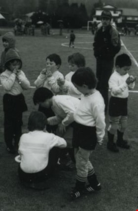
Cliff Avenue playoffs
https://search.heritageburnaby.ca/link/archivedescription38205
- Repository
- City of Burnaby Archives
- Date
- March 5, 1988 (date of original), copied 1991
- Collection/Fonds
- Burnaby Historical Society fonds
- Description Level
- Item
- Physical Description
- 1 photograph : b&w ; 4.6 x 3.0 cm print on contact sheet 20.3 x 26.6 cm
- Scope and Content
- Photograph of the Cliff Avenue soccer playoffs. The Aztecs team are shown at half time: Liam, Adam, Jason F., Marvin, Josh, Morgan, and Jonathan. Leanne F. and Jim Owen are in the background.
- Repository
- City of Burnaby Archives
- Date
- March 5, 1988 (date of original), copied 1991
- Collection/Fonds
- Burnaby Historical Society fonds
- Subseries
- Burnaby Image Bank subseries
- Physical Description
- 1 photograph : b&w ; 4.6 x 3.0 cm print on contact sheet 20.3 x 26.6 cm
- Description Level
- Item
- Record No.
- 370-792
- Access Restriction
- No restrictions
- Reproduction Restriction
- No restrictions
- Accession Number
- BHS1999-03
- Scope and Content
- Photograph of the Cliff Avenue soccer playoffs. The Aztecs team are shown at half time: Liam, Adam, Jason F., Marvin, Josh, Morgan, and Jonathan. Leanne F. and Jim Owen are in the background.
- Names
- Owen, Jim
- Media Type
- Photograph
- Notes
- Title based on contents of photograph
- 1 b&w copy negative accompanying
- Copied from col. photograph
- Historic Neighbourhood
- Capitol Hill (Historic Neighbourhood)
- Planning Study Area
- Capitol Hill Area
Images

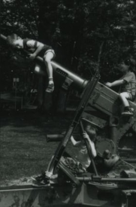
Boys playing on a large gun
https://search.heritageburnaby.ca/link/archivedescription38206
- Repository
- City of Burnaby Archives
- Date
- April 12, 1988 (date of original), copied 1991
- Collection/Fonds
- Burnaby Historical Society fonds
- Description Level
- Item
- Physical Description
- 1 photograph : b&w ; 4.6 x 3.0 cm print on contact sheet 20.3 x 26.6 cm
- Scope and Content
- Photograph of three boys, Morgan Ross, Matthew Owen and Jason Owen, playing on a gun in Confederation Park. This gun had movable parts, allowing park goers to operate it to some extent.
- Repository
- City of Burnaby Archives
- Date
- April 12, 1988 (date of original), copied 1991
- Collection/Fonds
- Burnaby Historical Society fonds
- Subseries
- Burnaby Image Bank subseries
- Physical Description
- 1 photograph : b&w ; 4.6 x 3.0 cm print on contact sheet 20.3 x 26.6 cm
- Description Level
- Item
- Record No.
- 370-793
- Access Restriction
- No restrictions
- Reproduction Restriction
- No restrictions
- Accession Number
- BHS1999-03
- Scope and Content
- Photograph of three boys, Morgan Ross, Matthew Owen and Jason Owen, playing on a gun in Confederation Park. This gun had movable parts, allowing park goers to operate it to some extent.
- Media Type
- Photograph
- Notes
- Title based on contents of photograph
- 1 b&w copy negative accompanying
- Copied from col. photograph
- Geographic Access
- Confederation Park
- Willingdon Avenue
- Street Address
- 250 Willingdon Avenue
- Historic Neighbourhood
- Capitol Hill (Historic Neighbourhood)
- Planning Study Area
- Capitol Hill Area
Images

![Svend Robinson with Rosemary Brown, [1988] thumbnail](/media/hpo/_Data/_Archives_Images/_Unrestricted/480/480-1222.jpg?width=280)
Svend Robinson with Rosemary Brown
https://search.heritageburnaby.ca/link/archivedescription46334
- Repository
- City of Burnaby Archives
- Date
- [1988]
- Collection/Fonds
- Columbian Newspaper collection
- Description Level
- Item
- Physical Description
- 1 photograph : b&w ; 21 x 19.5 cm
- Scope and Content
- Photograph of Svend Robinson and Rosemary Brown looking shocked after the federal election results come in.
- Repository
- City of Burnaby Archives
- Date
- [1988]
- Collection/Fonds
- Columbian Newspaper collection
- Physical Description
- 1 photograph : b&w ; 21 x 19.5 cm
- Description Level
- Item
- Record No.
- 480-1222
- Access Restriction
- No restrictions
- Reproduction Restriction
- No restrictions
- Accession Number
- 2003-02
- Scope and Content
- Photograph of Svend Robinson and Rosemary Brown looking shocked after the federal election results come in.
- Media Type
- Photograph
- Photographer
- Hodge, Craig
- Notes
- Title based on contents of photograph
- Note on recto of photograph reads: "You mean we lost. M.P. Svend Robinson + R. Brown."
- Newspaper clipping attached to verso of photograph reads: "MP Svend Robinson and Rosemary Brown gasp at results."
Images
![Svend Robinson with Rosemary Brown, [1988] thumbnail](/media/hpo/_Data/_Archives_Images/_Unrestricted/480/480-1222.jpg)
Interview with Steve Mancinelli by Kathy Bossort September 13, 2015 - Track 7
https://search.heritageburnaby.ca/link/oralhistory553
- Repository
- City of Burnaby Archives
- Date Range
- 1988-2015
- Length
- 0:10:02
- Summary
- This portion of the interview is about Steve Mancinelli’s beliefs about the value of the Burnaby Mountain Conservation Area, why people agreed to its preservation, and the role of the Society in rallying support for the preservation concept. He talks about how people use the mountain, and some of t…
- Repository
- City of Burnaby Archives
- Summary
- This portion of the interview is about Steve Mancinelli’s beliefs about the value of the Burnaby Mountain Conservation Area, why people agreed to its preservation, and the role of the Society in rallying support for the preservation concept. He talks about how people use the mountain, and some of the safety concerns, including the risk of meeting bears on the mountain and the problem of parking.
- Date Range
- 1988-2015
- Length
- 0:10:02
- Geographic Access
- Burnaby Mountain Conservation Area
- Interviewer
- Bossort, Kathy
- Interview Date
- September 13, 2015
- Scope and Content
- Recording is of an interview with Steve Mancinelli conducted by Kathy Bossort. Steve Mancinelli was one of 23 participants interviewed as part of the Community Heritage Commission’s Burnaby Mountain Oral History Project. The interview is mainly about the activities of the Burnaby Mountain Preservation Society between 1988 and 1997 and its advocacy for the protection of green space on Burnaby Mountain prior to the land transfer from SFU to Burnaby in 1995. Steve Mancinelli also talks about his other environmental and political activities, recreation on Burnaby Mountain, and the value of its natural assets.
- Biographical Notes
- Stephen Mancinelli was born in Vancouver in 1953 to Mario and Joan Mancinelli, one of three sons. The Mancinelli family moved to Burnaby in 1955 to the Cascade-Schou District. Steve attended Schou School (Gr. 1- 7) and Moscrop School (Gr. 8-10), playing as a child in the bush on the future Discovery Park site, before the family moved to Port Coquitlam. Steve moved back to Burnaby when he was 18, married his wife Glenda in 1980, and raised his family of two daughters (Julia and Aimee) in the Capital Hill District, before moving to Coquitlam in 2002. Employed as a sheet metal worker for 25 years, Steve has recently worked as a custodian for Coquitlam School District 43 for 19 years. Steve was one of the founding members of the Burnaby Mountain Preservation Society, and has also been a member of the Capital Hill Community Association, on the Board of Directors for Burnaby Psychiatric Services, and a Regional Director for the Green Party. Steve took an early interest in organic gardening, planting trees, and finding inventive ways to recycle waste and promote responsible use of the environment. Steve’s experience working on environmental issues was an important asset to the Burnaby Mountain Preservation Society, which formed ca. 1988 to become a key advocate for preserving parkland on Burnaby Mountain. The Society was awarded the City of Burnaby 1998 Environment Award in Communications for its work in preserving the Burnaby Mountain Conservation Area. In 2001 Steve was awarded an Environmental Star in Community Stewardship for being “active in preserving and enhancing Burnaby’s natural environment for over thirty years”.
- Total Tracks
- 9
- Total Length
- 1:31:42
- Interviewee Name
- Mancinelli, Stephen J. "Steve"
- Interview Location
- Steve Mancinelli's home in Burnaby
- Interviewer Bio
- Kathy Bossort is a retired archivist living in Ladner, BC. She worked at the Delta Museum and Archives after graduating from SLAIS (UBC) in 2001 with Masters degrees in library science and archival studies. Kathy grew up in Calgary, Alberta, and, prior to this career change, she lived in the West Kootenays, earning her living as a cook for BC tourist lodges and work camps. She continues to be interested in oral histories as a way to fill the gaps in the written record and bring richer meaning to history.
- Collection/Fonds
- Community Heritage Commission Special Projects fonds
- Media Type
- Sound Recording
Audio Tracks
Track seven of interview with Steve Mancinelli
Track seven of interview with Steve Mancinelli
https://search.heritageburnaby.ca/media/hpo/_Data/_Archives_Oral_Histories/_Unrestricted/MSS196-001/MSS196-001_Track_7.mp3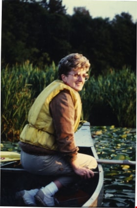
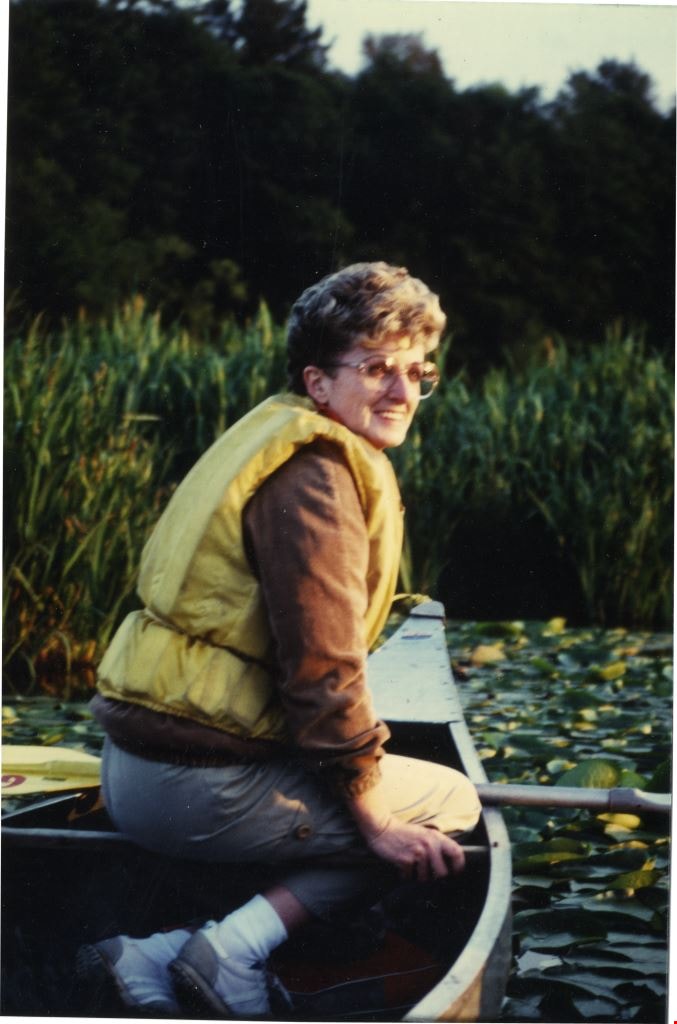
Doreen Lawson on Burnaby Lake
https://search.heritageburnaby.ca/link/archivedescription89072
- Repository
- City of Burnaby Archives
- Date
- 1988
- Collection/Fonds
- Doreen Lawson fonds
- Description Level
- File
- Physical Description
- 3 photographs : col. ; 15 x 10 cm
- Scope and Content
- File consists of two photographs of Doreen Lawson in a canoe on Burnaby Lake with a few other unidentified individuals and one photograph of Doreen Lawson standing next to an unidentified man looking over Burnaby Lake.
- Repository
- City of Burnaby Archives
- Date
- 1988
- Collection/Fonds
- Doreen Lawson fonds
- Physical Description
- 3 photographs : col. ; 15 x 10 cm
- Description Level
- File
- Record No.
- 605-008
- Access Restriction
- No restrictions
- Reproduction Restriction
- Reproduce for fair dealing purposes only
- Accession Number
- 2003-30
- Scope and Content
- File consists of two photographs of Doreen Lawson in a canoe on Burnaby Lake with a few other unidentified individuals and one photograph of Doreen Lawson standing next to an unidentified man looking over Burnaby Lake.
- Subjects
- Geographic Features - Lakes and Ponds
- Officials - Alderman and Councillors
- Recreational Activities - Canoeing
- Names
- Lawson, Doreen A.
- Media Type
- Photograph
- Notes
- Title based on content of photographs
- Note in black ink on verson of photographs reads: "Doreen Lawson '88"
- Historic Neighbourhood
- Burnaby Lake (Historic Neighbourhood)
- Planning Study Area
- Burnaby Lake Area
Images
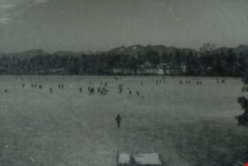
Skating on Deer Lake
https://search.heritageburnaby.ca/link/archivedescription37986
- Repository
- City of Burnaby Archives
- Date
- 1988 (date of original), copied 1991
- Collection/Fonds
- Burnaby Historical Society fonds
- Description Level
- Item
- Physical Description
- 1 photograph : b&w ; 3.1 x 4.6 cm print on contact sheet 20.7 x 26.2 cm
- Scope and Content
- Photograph of numerous people skating on Deer Lake.
- Repository
- City of Burnaby Archives
- Date
- 1988 (date of original), copied 1991
- Collection/Fonds
- Burnaby Historical Society fonds
- Subseries
- Burnaby Image Bank subseries
- Physical Description
- 1 photograph : b&w ; 3.1 x 4.6 cm print on contact sheet 20.7 x 26.2 cm
- Description Level
- Item
- Record No.
- 370-573
- Access Restriction
- No restrictions
- Reproduction Restriction
- No restrictions
- Accession Number
- BHS1999-03
- Scope and Content
- Photograph of numerous people skating on Deer Lake.
- Media Type
- Photograph
- Notes
- Title based on contents of photograph
- 1 b&w copy negative accompanying
- Copied from col. photograph
- Geographic Access
- Deer Lake
- Historic Neighbourhood
- Burnaby Lake (Historic Neighbourhood)
- Planning Study Area
- Oakalla Area
Images
