More like 'Book reading given by Pixie McGeachie January 10, 1973 - Track 6'
Narrow Results By
Subject
- Agriculture 1
- Agriculture - Farms 3
- Agriculture - Ranches 1
- Animals - Horses 1
- Animals - Pigs 1
- Artifacts 1
- Buildings - Civic - Community Centres 1
- Buildings - Civic - Hospitals 1
- Buildings - Civic - Museums 8
- Buildings - Commercial 2
- Buildings - Commercial - Grocery Stores 2
- Buildings - Commercial - Hardware Stores 1
Creator
- Associated Factory Mutual Fire Insurance Cos 1
- Burnaby School Board 1
- Burnaby Village Museum 9
- Burnett and McGugan B.C. Land Surveyors, New Westminster 5
- Burnett, Geoffrey K. 3
- Burnett & McGugan, Engineers and Surveyors 23
- Canadian Broadcasting Corporation 1
- Chenatte, Jeff 1
- City of Burnaby 4
- Debbie Liang 1
- Digney, Andy 11
- Digney, Ernest Frank "Dig" 2
![All Saints Church, [ca.1910] thumbnail](/media/hpo/_Data/_BVM_Cartographic_Material/2003/2003_0083_0046_001.jpg?width=280)
All Saints Church
https://search.heritageburnaby.ca/link/museumdescription11924
- Repository
- Burnaby Village Museum
- Date
- [ca.1910]
- Collection/Fonds
- Ronald G. Scobbie collection
- Description Level
- Item
- Physical Description
- 1 plan : black ink and watercol. on paper ; 30.45 x 30.5 cm
- Scope and Content
- Item consists of building insurance plan of "All Saints Church / Lot "A" BK 29 DL 98 GP1 N.W.D.". Watling Street is idenfied to the north of the church building and Royal Oak Avenue to the west.
- Repository
- Burnaby Village Museum
- Collection/Fonds
- Ronald G. Scobbie collection
- Description Level
- Item
- Physical Description
- 1 plan : black ink and watercol. on paper ; 30.45 x 30.5 cm
- Material Details
- Scale 1 inch = 20 feet
- Scope and Content
- Item consists of building insurance plan of "All Saints Church / Lot "A" BK 29 DL 98 GP1 N.W.D.". Watling Street is idenfied to the north of the church building and Royal Oak Avenue to the west.
- Subjects
- Buildings - Religious - Churches
- Accession Code
- BV003.83.46
- Access Restriction
- No restrictions
- Reproduction Restriction
- No known restrictions
- Date
- [ca.1910]
- Media Type
- Cartographic Material
- Scan Resolution
- 600
- Scan Date
- 15-Jan-2021
- Scale
- 100
- Notes
- Transcribed title
- Note in pencil on verso reads: ""All Saints Church / Lot "A" BK 29 DL 98 / Scale 1 inch = 20 feet"
- Note in balck in on verso reads: "3704"
Images
![All Saints Church, [ca.1910] thumbnail](/media/hpo/_Data/_BVM_Cartographic_Material/2003/2003_0083_0046_001.jpg)
![Anglican Church, [ca.1910] thumbnail](/media/hpo/_Data/_BVM_Cartographic_Material/2003/2003_0083_0043_001.jpg?width=280)
Anglican Church
https://search.heritageburnaby.ca/link/museumdescription11921
- Repository
- Burnaby Village Museum
- Date
- [ca.1910]
- Collection/Fonds
- Ronald G. Scobbie collection
- Description Level
- Item
- Physical Description
- 1 plan : black ink and watercol. on paper ; 30.45 x 30.5 cm
- Scope and Content
- Item consists of building insurance plan of "Anglican Church / Lot 2 BK 37 DL69, GP.1, N.W.D. (15th Ave. (Dominion) is identified to the north of Lots 1, 2 and 3).
- Repository
- Burnaby Village Museum
- Collection/Fonds
- Ronald G. Scobbie collection
- Description Level
- Item
- Physical Description
- 1 plan : black ink and watercol. on paper ; 30.45 x 30.5 cm
- Material Details
- Scale 1 inch = 20 feet
- Scope and Content
- Item consists of building insurance plan of "Anglican Church / Lot 2 BK 37 DL69, GP.1, N.W.D. (15th Ave. (Dominion) is identified to the north of Lots 1, 2 and 3).
- Subjects
- Buildings - Religious - Churches
- Accession Code
- BV003.83.43
- Access Restriction
- No restrictions
- Reproduction Restriction
- No known restrictions
- Date
- [ca.1910]
- Media Type
- Cartographic Material
- Scan Resolution
- 600
- Scan Date
- 15-Jan-2021
- Scale
- 100
- Notes
- Transcribed title
- Note in pencil on verso reads: "Anglican Church / Lot 2 Bk 37 DL69 / 1"=20' "
- Note in balck in on verso reads: "3704"
Images
![Anglican Church, [ca.1910] thumbnail](/media/hpo/_Data/_BVM_Cartographic_Material/2003/2003_0083_0043_001.jpg)
![Broadview Presbyterian Church, [ca.1910] thumbnail](/media/hpo/_Data/_BVM_Cartographic_Material/2003/2003_0083_0049_001.jpg?width=280)
Broadview Presbyterian Church
https://search.heritageburnaby.ca/link/museumdescription11927
- Repository
- Burnaby Village Museum
- Date
- [ca.1910]
- Collection/Fonds
- Ronald G. Scobbie collection
- Description Level
- Item
- Physical Description
- 1 plan : black ink and watercol. on paper ; 30.45 x 30.5 cm
- Scope and Content
- Item consists of building insurance plan of "Broadview Presbyterian Church / Lot 6, BK 31, DL 69 / GP1 N.W.D." . Fourteenth Avenue (Manor) is identified to the north and Douglas Ave. to the east.
- Repository
- Burnaby Village Museum
- Collection/Fonds
- Ronald G. Scobbie collection
- Description Level
- Item
- Physical Description
- 1 plan : black ink and watercol. on paper ; 30.45 x 30.5 cm
- Material Details
- Scale 1 inch = 20 feet
- Scope and Content
- Item consists of building insurance plan of "Broadview Presbyterian Church / Lot 6, BK 31, DL 69 / GP1 N.W.D." . Fourteenth Avenue (Manor) is identified to the north and Douglas Ave. to the east.
- Subjects
- Buildings - Religious - Churches
- Accession Code
- BV003.83.49
- Access Restriction
- No restrictions
- Reproduction Restriction
- No known restrictions
- Date
- [ca.1910]
- Media Type
- Cartographic Material
- Scan Resolution
- 600
- Scan Date
- 15-Jan-2021
- Scale
- 100
- Notes
- Transcribed title
- Note in pencil on verso reads: "Broadview Presbyterian Church / Lot 6, BK 31, DL 69 / 1" = 20' "
- Note in balck in on verso reads: "3704"
Images
![Broadview Presbyterian Church, [ca.1910] thumbnail](/media/hpo/_Data/_BVM_Cartographic_Material/2003/2003_0083_0049_001.jpg)
![Dundonald United Church, [ca.1910] thumbnail](/media/hpo/_Data/_BVM_Cartographic_Material/2003/2003_0083_0052_001.jpg?width=280)
Dundonald United Church
https://search.heritageburnaby.ca/link/museumdescription11930
- Repository
- Burnaby Village Museum
- Date
- [ca.1910]
- Collection/Fonds
- Ronald G. Scobbie collection
- Description Level
- Item
- Physical Description
- 1 plan : black ink and watercol. on paper ; 30.45 x 30.5 cm
- Scope and Content
- Item consists of a building insurance plan of "Dundonald United Church / Lots 9, 10 BK 28 DL 159 GP 1 / N.W.D.". Clinton Street is identified to the north of Lots nine and ten.
- Repository
- Burnaby Village Museum
- Collection/Fonds
- Ronald G. Scobbie collection
- Description Level
- Item
- Physical Description
- 1 plan : black ink and watercol. on paper ; 30.45 x 30.5 cm
- Material Details
- Scale 1 inch = 20 feet
- Scope and Content
- Item consists of a building insurance plan of "Dundonald United Church / Lots 9, 10 BK 28 DL 159 GP 1 / N.W.D.". Clinton Street is identified to the north of Lots nine and ten.
- Subjects
- Buildings - Religious - Churches
- Names
- Dundonald United Church
- Accession Code
- BV003.83.52
- Access Restriction
- No restrictions
- Reproduction Restriction
- No known restrictions
- Date
- [ca.1910]
- Media Type
- Cartographic Material
- Scan Resolution
- 600
- Scan Date
- 15-Jan-2021
- Scale
- 100
- Notes
- Transcribed title
- Note in pencil on verso reads: "_ _Church / Lots 9 & 10 BK 28 DL 159 / 1" = 20' "
- Note in black ink on verso reads: "3704"
Images
![Dundonald United Church, [ca.1910] thumbnail](/media/hpo/_Data/_BVM_Cartographic_Material/2003/2003_0083_0052_001.jpg)
![East Burnaby United Church, [ca.1925] thumbnail](/media/hpo/_Data/_BVM_Cartographic_Material/2003/2003_0083_0054_001.jpg?width=280)
East Burnaby United Church
https://search.heritageburnaby.ca/link/museumdescription11932
- Repository
- Burnaby Village Museum
- Date
- [ca.1925]
- Collection/Fonds
- Ronald G. Scobbie collection
- Description Level
- Item
- Physical Description
- 1 plan : black ink and watercol. on paper ; 30.45 x 30.5 cm
- Scope and Content
- Item consists of a building insurance plan of "East Burnaby United Church / Lot 1 BK 2 south Part DL 28 GP 1 N.W.D.". Twelfth Avenue is identified to the north and Douglas Road to the west.
- Repository
- Burnaby Village Museum
- Collection/Fonds
- Ronald G. Scobbie collection
- Description Level
- Item
- Physical Description
- 1 plan : black ink and watercol. on paper ; 30.45 x 30.5 cm
- Material Details
- Scale 1 inch = 20 feet
- Scope and Content
- Item consists of a building insurance plan of "East Burnaby United Church / Lot 1 BK 2 south Part DL 28 GP 1 N.W.D.". Twelfth Avenue is identified to the north and Douglas Road to the west.
- Subjects
- Buildings - Religious - Churches
- Accession Code
- BV003.83.54
- Access Restriction
- No restrictions
- Reproduction Restriction
- No known restrictions
- Date
- [ca.1925]
- Media Type
- Cartographic Material
- Scan Resolution
- 600
- Scan Date
- 15-Jan-2021
- Scale
- 100
- Notes
- Transcribed title
- Note in pencil on verso reads: "East Burnaby United Church / Lot 1 BK 2 south Part DL 28 / 1" = 20' "
- Note in black ink on verso reads: "3704"
Images
![East Burnaby United Church, [ca.1925] thumbnail](/media/hpo/_Data/_BVM_Cartographic_Material/2003/2003_0083_0054_001.jpg)
![Gordon Presbyterian Church, [ca.1912] thumbnail](/media/hpo/_Data/_BVM_Cartographic_Material/2003/2003_0083_0045_001.jpg?width=280)
Gordon Presbyterian Church
https://search.heritageburnaby.ca/link/museumdescription11923
- Repository
- Burnaby Village Museum
- Date
- [ca.1912]
- Collection/Fonds
- Ronald G. Scobbie collection
- Description Level
- Item
- Physical Description
- 1 plan : black ink and watercol. on paper ; 30.45 x 30.5 cm
- Scope and Content
- Item consists of building insurance plan of "Gordon Presbyterian Church / Blocks 1-2 BK 7 DL 30 GP1 N.W.D.". Arbutus Street is identified to the north of Lots 1, 2, & 3 and Humphries Avenue to the east.
- Repository
- Burnaby Village Museum
- Collection/Fonds
- Ronald G. Scobbie collection
- Description Level
- Item
- Physical Description
- 1 plan : black ink and watercol. on paper ; 30.45 x 30.5 cm
- Material Details
- Scale 1 inch = 20 feet
- Scope and Content
- Item consists of building insurance plan of "Gordon Presbyterian Church / Blocks 1-2 BK 7 DL 30 GP1 N.W.D.". Arbutus Street is identified to the north of Lots 1, 2, & 3 and Humphries Avenue to the east.
- Subjects
- Buildings - Religious - Churches
- Accession Code
- BV003.83.45
- Access Restriction
- No restrictions
- Reproduction Restriction
- No known restrictions
- Date
- [ca.1912]
- Media Type
- Cartographic Material
- Scan Resolution
- 600
- Scan Date
- 15-Jan-2021
- Scale
- 100
- Notes
- Transcribed title
- Note in pencil on verso reads: "Gordon Presbyterian Church / Blocks 1-2 BK 7 DL 30 / Scale 1 inch = 20 feet" "Total area Lot 1 / Portion exempted / Total area Lot 2 / Portion exempted"
- Note in balck in on verso reads: "3704"
Images
![Gordon Presbyterian Church, [ca.1912] thumbnail](/media/hpo/_Data/_BVM_Cartographic_Material/2003/2003_0083_0045_001.jpg)
![St. Albans the Martyr, [ca.1910] thumbnail](/media/hpo/_Data/_BVM_Cartographic_Material/2003/2003_0083_0048_001.jpg?width=280)
St. Albans the Martyr
https://search.heritageburnaby.ca/link/museumdescription11926
- Repository
- Burnaby Village Museum
- Date
- [ca.1910]
- Collection/Fonds
- Ronald G. Scobbie collection
- Description Level
- Item
- Physical Description
- 1 plan : black ink and watercol. on paper ; 30.45 x 30.5 cm
- Scope and Content
- Item consists of building insurance plan of "St. Albans the Martyr / Lots 45 & 46 North Part DL 28 / GP1 N.W.D." Edmonds Street is to the north, Douglas Road to the west and 19th Avenue to the south.
- Repository
- Burnaby Village Museum
- Collection/Fonds
- Ronald G. Scobbie collection
- Description Level
- Item
- Physical Description
- 1 plan : black ink and watercol. on paper ; 30.45 x 30.5 cm
- Material Details
- Scale 1 inch = 40 feet
- Scope and Content
- Item consists of building insurance plan of "St. Albans the Martyr / Lots 45 & 46 North Part DL 28 / GP1 N.W.D." Edmonds Street is to the north, Douglas Road to the west and 19th Avenue to the south.
- Subjects
- Buildings - Religious - Churches
- Accession Code
- BV003.83.48
- Access Restriction
- No restrictions
- Reproduction Restriction
- No known restrictions
- Date
- [ca.1910]
- Media Type
- Cartographic Material
- Scan Resolution
- 600
- Scan Date
- 15-Jan-2021
- Scale
- 100
- Notes
- Transcribed title
- Note in pencil on verso reads: "St. Albans the Martyr / Lots 45 & 46 North Part DL 28 / 1" = 40' "
- Note in balck in on verso reads: "3704"
Images
![St. Albans the Martyr, [ca.1910] thumbnail](/media/hpo/_Data/_BVM_Cartographic_Material/2003/2003_0083_0048_001.jpg)
![St. Helen's Church, [ca.1910] thumbnail](/media/hpo/_Data/_BVM_Cartographic_Material/2003/2003_0083_0051_001.jpg?width=280)
St. Helen's Church
https://search.heritageburnaby.ca/link/museumdescription11929
- Repository
- Burnaby Village Museum
- Date
- [ca.1910]
- Collection/Fonds
- Ronald G. Scobbie collection
- Description Level
- Item
- Physical Description
- 1 plan : black ink and watercol. on paper ; 30.45 x 30.5 cm
- Scope and Content
- Item consists of building insurance plan of "St. Helen's Church / Lots 11 & 12 BK 7 DL 186 / GP1 N.W.D." . Ingleton Ave is identified to the east and Pandora St. to the south.
- Repository
- Burnaby Village Museum
- Collection/Fonds
- Ronald G. Scobbie collection
- Description Level
- Item
- Physical Description
- 1 plan : black ink and watercol. on paper ; 30.45 x 30.5 cm
- Material Details
- Scale 1 inch = 20 feet
- Scope and Content
- Item consists of building insurance plan of "St. Helen's Church / Lots 11 & 12 BK 7 DL 186 / GP1 N.W.D." . Ingleton Ave is identified to the east and Pandora St. to the south.
- Subjects
- Buildings - Religious - Churches
- Accession Code
- BV003.83.51
- Access Restriction
- No restrictions
- Reproduction Restriction
- No known restrictions
- Date
- [ca.1910]
- Media Type
- Cartographic Material
- Scan Resolution
- 600
- Scan Date
- 15-Jan-2021
- Scale
- 100
- Notes
- Transcribed title
- Note in pencil on verso reads: ""St. Helen's Church / Lots 11 & 12 BK 7 DL 186 / 1" = 20' "
- Note in balck in on verso reads: "3704"
Images
![St. Helen's Church, [ca.1910] thumbnail](/media/hpo/_Data/_BVM_Cartographic_Material/2003/2003_0083_0051_001.jpg)
![St. John the Divine, [ca.1910] thumbnail](/media/hpo/_Data/_BVM_Cartographic_Material/2003/2003_0083_0044_001.jpg?width=280)
St. John the Divine
https://search.heritageburnaby.ca/link/museumdescription11922
- Repository
- Burnaby Village Museum
- Date
- [ca.1910]
- Collection/Fonds
- Ronald G. Scobbie collection
- Description Level
- Item
- Physical Description
- 1 plan : black ink and watercol. on paper ; 30.45 x 30.5 cm
- Scope and Content
- Item consists of building insurance plan of "St. John the Divine / Lot "A" BK. 49 DL 35 GP1 N.W.D.". Kingsway is identified to the south of building.
- Repository
- Burnaby Village Museum
- Collection/Fonds
- Ronald G. Scobbie collection
- Description Level
- Item
- Physical Description
- 1 plan : black ink and watercol. on paper ; 30.45 x 30.5 cm
- Material Details
- Scale 1 inch = 20 feet
- Scope and Content
- Item consists of building insurance plan of "St. John the Divine / Lot "A" BK. 49 DL 35 GP1 N.W.D.". Kingsway is identified to the south of building.
- Subjects
- Buildings - Religious - Churches
- Accession Code
- BV003.83.44
- Access Restriction
- No restrictions
- Reproduction Restriction
- No known restrictions
- Date
- [ca.1910]
- Media Type
- Cartographic Material
- Scan Resolution
- 600
- Scan Date
- 15-Jan-2021
- Scale
- 100
- Notes
- Transcribed title
- Note in pencil on verso reads: "St. John the Divine / Lot "A" BK. 49 DL 35 / 1"=20' "
- Note in balck in on verso reads: "3704"
Images
![St. John the Divine, [ca.1910] thumbnail](/media/hpo/_Data/_BVM_Cartographic_Material/2003/2003_0083_0044_001.jpg)
![St. Margaret's Anglican Mission, [1929] thumbnail](/media/hpo/_Data/_BVM_Cartographic_Material/2003/2003_0083_0050_001.jpg?width=280)
St. Margaret's Anglican Mission
https://search.heritageburnaby.ca/link/museumdescription11928
- Repository
- Burnaby Village Museum
- Date
- [1929]
- Collection/Fonds
- Ronald G. Scobbie collection
- Description Level
- Item
- Physical Description
- 1 plan : black ink and watercol. on paper ; 30.45 x 30.5 cm
- Scope and Content
- Item consists of building insurance plan for St. Margaret of Scotland Anglican Church. Title of plan reads: "St. Margaret's Anglican Mission (note:"Church" has been crossed out and corrected with "Mission") / Lot 10, DL 132 / GP1 N.W.D." . Curtis Street is identified to the north and Sperling Av…
- Repository
- Burnaby Village Museum
- Collection/Fonds
- Ronald G. Scobbie collection
- Description Level
- Item
- Physical Description
- 1 plan : black ink and watercol. on paper ; 30.45 x 30.5 cm
- Material Details
- Scale 1 inch = 40 feet
- Scope and Content
- Item consists of building insurance plan for St. Margaret of Scotland Anglican Church. Title of plan reads: "St. Margaret's Anglican Mission (note:"Church" has been crossed out and corrected with "Mission") / Lot 10, DL 132 / GP1 N.W.D." . Curtis Street is identified to the north and Sperling Ave. to the west.
- Subjects
- Buildings - Religious - Churches
- Geographic Access
- Sperling Avenue
- Curtis Street
- Accession Code
- BV003.83.50
- Access Restriction
- No restrictions
- Reproduction Restriction
- No known restrictions
- Date
- [1929]
- Media Type
- Cartographic Material
- Scan Resolution
- 600
- Scan Date
- 15-Jan-2021
- Scale
- 100
- Notes
- Transcribed title
- Note in pencil on verso reads: "St. Margaret's Anglican Mission / Lot 10, DL 132 / 1" = 40' "
- Note in balck in on verso reads: "3704"
Images
![St. Margaret's Anglican Mission, [1929] thumbnail](/media/hpo/_Data/_BVM_Cartographic_Material/2003/2003_0083_0050_001.jpg)
![St. Nicolas Parish Church, [ca.1912] thumbnail](/media/hpo/_Data/_BVM_Cartographic_Material/2003/2003_0083_0053_001.jpg?width=280)
St. Nicolas Parish Church
https://search.heritageburnaby.ca/link/museumdescription11931
- Repository
- Burnaby Village Museum
- Date
- [ca.1912]
- Collection/Fonds
- Ronald G. Scobbie collection
- Description Level
- Item
- Physical Description
- 1 plan : black ink and watercol. on paper ; 30.45 x 30.5 cm
- Scope and Content
- Item consists of a building insurance plan of St. Nicholas Anglican Church. Title on plan reads "St. Nicolas [sic] Parish Church / Lots 11 & 12 BK 10 DL 186 GP 1 / N.W.D.". Ingleton Avenue is identified to the east and Triumph Street to the south.
- Repository
- Burnaby Village Museum
- Collection/Fonds
- Ronald G. Scobbie collection
- Description Level
- Item
- Physical Description
- 1 plan : black ink and watercol. on paper ; 30.45 x 30.5 cm
- Material Details
- Scale 1 inch = 20 feet
- Scope and Content
- Item consists of a building insurance plan of St. Nicholas Anglican Church. Title on plan reads "St. Nicolas [sic] Parish Church / Lots 11 & 12 BK 10 DL 186 GP 1 / N.W.D.". Ingleton Avenue is identified to the east and Triumph Street to the south.
- Subjects
- Buildings - Religious - Churches
- Geographic Access
- Triumph Street
- Street Address
- 3883 Triumph Street
- Accession Code
- BV003.83.53
- Access Restriction
- No restrictions
- Reproduction Restriction
- No known restrictions
- Date
- [ca.1912]
- Media Type
- Cartographic Material
- Historic Neighbourhood
- Vancouver Heights (Historic Neighbourhood)
- Scan Resolution
- 600
- Scan Date
- 15-Jan-2021
- Scale
- 100
- Notes
- Transcribed title
- Note in pencil on verso reads: "St. Nicholas Parish Church / Lots 11 & 12 BK 10 DL 186 / 1" = 20' "
- Note in black ink on verso reads: "3704"
Images
![St. Nicolas Parish Church, [ca.1912] thumbnail](/media/hpo/_Data/_BVM_Cartographic_Material/2003/2003_0083_0053_001.jpg)
![St. Stephens, [ca.1912] thumbnail](/media/hpo/_Data/_BVM_Cartographic_Material/2003/2003_0083_0047_001.jpg?width=280)
St. Stephens
https://search.heritageburnaby.ca/link/museumdescription11925
- Repository
- Burnaby Village Museum
- Date
- [ca.1912]
- Collection/Fonds
- Ronald G. Scobbie collection
- Description Level
- Item
- Physical Description
- 1 plan : black ink and watercol. on paper ; 30.45 x 30.5 cm
- Scope and Content
- Item consists of building insurance plan of "St. Stephens / Lot A BK 1 DL 6 GP1 N.W.D." Cameron Street is indentified to the south of Lot A BK 1. District Lot 6.
- Repository
- Burnaby Village Museum
- Collection/Fonds
- Ronald G. Scobbie collection
- Description Level
- Item
- Physical Description
- 1 plan : black ink and watercol. on paper ; 30.45 x 30.5 cm
- Material Details
- Scale 1 inch = 30 feet
- Scope and Content
- Item consists of building insurance plan of "St. Stephens / Lot A BK 1 DL 6 GP1 N.W.D." Cameron Street is indentified to the south of Lot A BK 1. District Lot 6.
- Subjects
- Buildings - Religious - Churches
- Accession Code
- BV003.83.47
- Access Restriction
- No restrictions
- Reproduction Restriction
- No known restrictions
- Date
- [ca.1912]
- Media Type
- Cartographic Material
- Scan Resolution
- 600
- Scan Date
- 15-Jan-2021
- Scale
- 100
- Notes
- Transcribed title
- Note in pencil on verso reads: "St. Stephens / Lot A BK 1, DL 6 / 30' = 1" "
- Note in balck in on verso reads: "3704"
Images
![St. Stephens, [ca.1912] thumbnail](/media/hpo/_Data/_BVM_Cartographic_Material/2003/2003_0083_0047_001.jpg)

Welcome back to Bonsor
https://search.heritageburnaby.ca/link/museumdescription15387
- Repository
- Burnaby Village Museum
- Date
- September 2020
- Collection/Fonds
- Burnaby Village Museum COVID-19 collection
- Description Level
- Item
- Physical Description
- 1 video recording (mp4) (2 min., 31 sec.) : digital, 24 fps, col., sd., stereo
- Scope and Content
- City of Burnaby film welcoming the public back to Bonsor Recreation Complex after it was closed following public health restrictions in the spring of 2020. The film provides information to the public regarding the new procedures and protocols that were put in place and how they will be operating at…
- Repository
- Burnaby Village Museum
- Collection/Fonds
- Burnaby Village Museum COVID-19 collection
- Description Level
- Item
- Physical Description
- 1 video recording (mp4) (2 min., 31 sec.) : digital, 24 fps, col., sd., stereo
- Scope and Content
- City of Burnaby film welcoming the public back to Bonsor Recreation Complex after it was closed following public health restrictions in the spring of 2020. The film provides information to the public regarding the new procedures and protocols that were put in place and how they will be operating at a reduced capacity to allow for physical distancing and enhanced cleaning.
- History
- Video taken by the City of Burnaby Marketing Department in 2020. The original intent of the clip was to produce communications about the pandemic and changes throughout the City that residents needed to be aware of.
- Creator
- City of Burnaby
- Subjects
- Buildings - Recreational
- Buildings - Recreational - Sports
- Buildings - Recreational - Swimming Pools
- Buildings - Civic - Community Centres
- Public Services - Municipal Services
- Pandemics - COVID-19
- Geographic Access
- Bonsor Avenue
- Street Address
- 6550 Bonsor Avenue
- Accession Code
- BV021.2.4
- Access Restriction
- No restrictions
- Reproduction Restriction
- May be restricted by third party rights
- Date
- September 2020
- Media Type
- Moving Images
- Historic Neighbourhood
- Central Park (Historic Neighbourhood)
- Planning Study Area
- Marlborough Area
- Notes
- Title based on contents of film
Images

Video
Welcome back to Bonsor, September 2020
Welcome back to Bonsor, September 2020
https://search.heritageburnaby.ca/media/hpo/_Data/_BVM_Moving_Images/2021_0002_0004_001.mp4
Bell's Dry Goods
https://search.heritageburnaby.ca/link/museumdescription14036
- Repository
- Burnaby Village Museum
- Date
- 11 Aug. 1994
- Collection/Fonds
- Burnaby Village Museum fonds
- Description Level
- Item
- Physical Description
- 1 videocassette (62 min., 50 sec.) : VHS, col., sd.
- Scope and Content
- Film footage of an interview conducted and recorded by Burnaby Village Museum curator Colin Stevens with Burnaby residents gathered inside of Bell's Dry Goods store on the site of Burnaby Village Museum. Burnaby residents were customers and friends of Mr. and Mrs. Bell and included: Jim Agnew; Mary…
- Repository
- Burnaby Village Museum
- Collection/Fonds
- Burnaby Village Museum fonds
- Subseries
- Bell's research files subseries
- Description Level
- Item
- Physical Description
- 1 videocassette (62 min., 50 sec.) : VHS, col., sd.
- Scope and Content
- Film footage of an interview conducted and recorded by Burnaby Village Museum curator Colin Stevens with Burnaby residents gathered inside of Bell's Dry Goods store on the site of Burnaby Village Museum. Burnaby residents were customers and friends of Mr. and Mrs. Bell and included: Jim Agnew; Mary Agne; May and Bill Long; Mel Coutts; Lois Coutts; Isobel Coutts and Aubrey Coutts. These residents all lived in the area of the building and knew the owners between 1920 and 1950. Residents recall the layout and furnishings of the interior of the building when it was operated as Bell's Dry Goods (1925 to 1937), Jean's Grocery Store [?], Whitechurch Hardware (1937-1973). Colin Stevens is particularly interested in gathering information on the layout and furnishings in Bell's since the museum intends to restore the building and display to the 1920s era.
- Creator
- Stevens, Colin
- Subjects
- Buildings - Commercial
- Buildings - Commercial - Grocery Stores
- Buildings - Commercial - Hardware Stores
- Names
- Agnew, Jim
- Agnew, Mary
- Coutts, Mel
- Coutts, Lois Hollands
- Coutts, Aubrey
- Coutts, Isobel
- Long, May Walker
- Long, Bill
- Stevens, Colin
- Accession Code
- BV020.5.737
- Access Restriction
- Restricted access
- Reproduction Restriction
- May be restricted by third party rights
- Date
- 11 Aug. 1994
- Media Type
- Moving Images
- Notes
- Title based on contents
- Label on videocassette reads: "Bells' Dry Goods" / "Interview with People / who used to shop there / at / "Bells' Dry Goods" / 6th St. Burnaby / 1994 Aug 11 Colin Stevens"
Images


Cabin
https://search.heritageburnaby.ca/link/museumdescription13061
- Repository
- Burnaby Village Museum
- Date
- 1973 (date of original), digitized in 2020
- Collection/Fonds
- Burnaby Village Museum Film and Video collection
- Description Level
- Item
- Physical Description
- 1 film reel (22 min., 22 sec.) : 24 fps, polyester, positive, col., sd. ; 16 mm
- Scope and Content
- Item consists of a film titled "Cabin" that is produced and directed by James Bizzochi. The film documents the building of a log cabin using pioneer tools. The building takes place at Heritage Village (now Burnaby Village Museum) and includes a commentary by the craftsman, Earl Carter. Opening foot…
- Repository
- Burnaby Village Museum
- Collection/Fonds
- Burnaby Village Museum Film and Video collection
- Description Level
- Item
- Physical Description
- 1 film reel (22 min., 22 sec.) : 24 fps, polyester, positive, col., sd. ; 16 mm
- Material Details
- Producer and Director - James Bizzocchi
- Cabin building and narration - Earl Carter
- Editing- Justine Dancy
- Director of Cinematography - Selwyn Pullan
- Music- Ralph Dyck
- Titles - Carl Chaplin
- Scope and Content
- Item consists of a film titled "Cabin" that is produced and directed by James Bizzochi. The film documents the building of a log cabin using pioneer tools. The building takes place at Heritage Village (now Burnaby Village Museum) and includes a commentary by the craftsman, Earl Carter. Opening footage includes historic photographs from the Vancouver Public Library Photographic collection.
- History
- Film director and producer James (Jim) Bizzochi is a moving image artist living and working in British Columbia. Jim created the film while working as a professor with Simon Fraser University. Cinematographer Selwyn Pullan is a distinguised Canadian photographer who specialized in building photography documenting B.C. mid-century modernism.
- Publisher
- Copyright 1973, Jim Bizzocchi. All rights reserved,
- Other Title Information
- Copyright 1973, Jim Bizzocchi. All rights reserved,
- Subjects
- Buildings - Civic - Museums
- Buildings - Residential - Cabins
- Construction
- Construction Tools and Equipment
- Names
- Carter, Earl
- Bizzocchi, James
- Pullan, Selwyn
- Chaplin, Carl
- Dancy, Justine
- Dyck, Ralph
- Burnaby Village Museum
- Accession Code
- BV020.5.709
- Access Restriction
- Restricted access
- Reproduction Restriction
- May be restricted by third party rights
- Date
- 1973 (date of original), digitized in 2020
- Media Type
- Moving Images
- Photographer
- Pullan, Selwyn
- Notes
- Transcribed title
- Copyright MCMLXXIII
- Film under copyright - for Fair Dealing Purposes only
- End Credits : "Thanks to / Heritage Village Museum - Burnaby / Simon Fraser University Film Workshop / Vancouver Public Library Photographic Collection"
Images

Video
Cabin, 1973 (date of original), digitized in 2020
Cabin, 1973 (date of original), digitized in 2020
https://search.heritageburnaby.ca/media/hpo/_Data/_BVM_Moving_Images/2020_0005_0709_001.mp4![Digney film 2 - Construction of Simpsons-Sears building, [1954] (date of original), copied 2019 thumbnail](/media/hpo/_Data/_BVM_Moving_Images/2019_0018_0004_013.jpg?width=280)
Digney film 2 - Construction of Simpsons-Sears building
https://search.heritageburnaby.ca/link/museumdescription10644
- Repository
- Burnaby Village Museum
- Date
- [1954] (date of original), copied 2019
- Collection/Fonds
- Digney Family fonds
- Description Level
- Item
- Physical Description
- 1 video recording (mp4) (1 min., 30 sec.) : digital, 23 fps, col., si.
- Scope and Content
- Film segment documenting the construction of the Simpsons-Sears building located at 3660 Kingsway in Burnaby (address changed to 4750 Kingsway after 1958). The film footage is shot by Andy Digney from his backyard at 2698 Bonsor Avenue (address changed to 6521 Bonsor Avenue after 1958).
- Repository
- Burnaby Village Museum
- Collection/Fonds
- Digney Family fonds
- Description Level
- Item
- Physical Description
- 1 video recording (mp4) (1 min., 30 sec.) : digital, 23 fps, col., si.
- Scope and Content
- Film segment documenting the construction of the Simpsons-Sears building located at 3660 Kingsway in Burnaby (address changed to 4750 Kingsway after 1958). The film footage is shot by Andy Digney from his backyard at 2698 Bonsor Avenue (address changed to 6521 Bonsor Avenue after 1958).
- Creator
- Digney, Andy
- Names
- Simpsons-Sears Limited
- Geographic Access
- Kingsway
- Street Address
- 4750 Kingsway
- Accession Code
- BV019.18.4.13
- Access Restriction
- No restrictions
- Reproduction Restriction
- No known restrictions
- Date
- [1954] (date of original), copied 2019
- Media Type
- Moving Images
- Historic Neighbourhood
- Central Park (Historic Neighbourhood)
- Planning Study Area
- Maywood Area
- Photographer
- Digney, Andy
- Notes
- Title based on contents of film segment
- Film segment originates from digitized version of original 8 mm film (See BV019.18.4)
Images
![Digney film 2 - Construction of Simpsons-Sears building, [1954] (date of original), copied 2019 thumbnail](/media/hpo/_Data/_BVM_Moving_Images/2019_0018_0004_013.jpg)
Video
Digney film 2 - Construction of Simpsons-Sears building, [1954] (date of original), copied 2019
Digney film 2 - Construction of Simpsons-Sears building, [1954] (date of original), copied 2019
https://search.heritageburnaby.ca/media/hpo/_Data/_BVM_Moving_Images/2019_0018_0004_013.mp4Digney film 2 - Family in Burnaby, Construction of Simpsons-Sears building and wedding
https://search.heritageburnaby.ca/link/museumdescription10598
- Repository
- Burnaby Village Museum
- Date
- [between 1954 and 1964] (date of original), copied 2019
- Collection/Fonds
- Digney Family fonds
- Description Level
- File
- Physical Description
- 1 video recording (mp4) (26 min., 51 sec.) : digital, 16 fps, col., si.
- Scope and Content
- Film compilation created by Andy Digney and his son Ernest "Dig" Digney. The film opens with scenes of different dogs playing outside; exterior of Andy and Alice Digney’s house on Kaymar Drive; interior of the Digney bowling alley with pins being reset; interior of Andy Digney’s greenhouse at his h…
- Repository
- Burnaby Village Museum
- Collection/Fonds
- Digney Family fonds
- Description Level
- File
- Physical Description
- 1 video recording (mp4) (26 min., 51 sec.) : digital, 16 fps, col., si.
- Scope and Content
- Film compilation created by Andy Digney and his son Ernest "Dig" Digney. The film opens with scenes of different dogs playing outside; exterior of Andy and Alice Digney’s house on Kaymar Drive; interior of the Digney bowling alley with pins being reset; interior of Andy Digney’s greenhouse at his house on Kaymar Drive; construction of the Simpsons-Sears building in 1954 behind the Digney home at 3698 Bonsor Street; unidentified outdoor wedding attended by the Digney's and Swans; Campbell family gathering in Victoria; gathering of friends and family inside Alice and Andy Digney’s home on Kaymar Drive before they leave for their World tour in 1964.
- Creator
- Digney, Andy
- Geographic Access
- Bonsor Avenue
- Kaymar Drive
- Accession Code
- BV019.18.4
- Access Restriction
- No restrictions
- Reproduction Restriction
- No known restrictions
- Date
- [between 1954 and 1964] (date of original), copied 2019
- Media Type
- Moving Images
- Photographer
- Digney, Andy
- Digney, Ernest Frank "Dig"
- Notes
- Title based on contents of film
- Digitized film is a copy from original 8 mm film
- 9 film clips from this compilation are described at item level and available for viewing on Heritage Burnaby
- Contact Burnaby Village Museum to view entire content
The Store
https://search.heritageburnaby.ca/link/museumdescription9683
- Repository
- Burnaby Village Museum
- Date
- 2016
- Collection/Fonds
- Burnaby Village Museum Film and Video collection
- Description Level
- Item
- Physical Description
- 1 video recording (mp4) (3 min., 4 sec.) : digital, 25 fps, col., sd., stereo
- Scope and Content
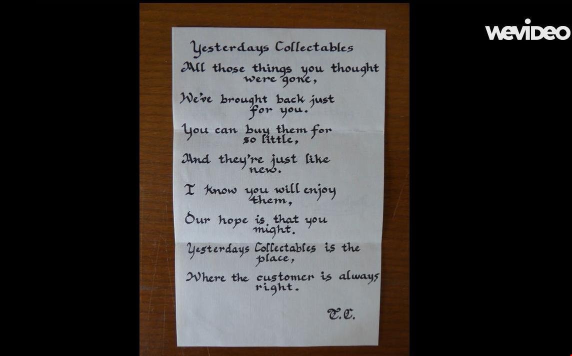
- In “The Store” film maker Teresa Switzer reminds us of the power of second chances. She shares the story of opening a second hand store called “Yesterday’s Collectibles” with her friend, Pete. The store was located on West Broadway in Vancouver from 1983 to 1985. She recalls the challenges of opera…
- Repository
- Burnaby Village Museum
- Collection/Fonds
- Burnaby Village Museum Film and Video collection
- Description Level
- Item
- Physical Description
- 1 video recording (mp4) (3 min., 4 sec.) : digital, 25 fps, col., sd., stereo
- Scope and Content
- In “The Store” film maker Teresa Switzer reminds us of the power of second chances. She shares the story of opening a second hand store called “Yesterday’s Collectibles” with her friend, Pete. The store was located on West Broadway in Vancouver from 1983 to 1985. She recalls the challenges of operating a small business, coupled with the personal challenge of the end of her marriage. The film ends with a reflection on the lessons learned from the experience, and her good fortune of finding a second chance with her new partner, Patrick.
- History
- Teresa Switzer is originally from Winnipeg. She moved to the Westcoast in 1973, and has lived in South Burnaby since 1997. After the store closed, Teresa worked as a project coordinator for cancer research at UBC and BC Cancer Research. Teresa and Patrick Lucy were together from 1985 until Patrick passed away in 2007. Patrick was an Exhibit Preparator at Burnaby Village Museum for 13 years before retiring in 2006.
- Creator
- Switzer, Teresa
- Other Title Information
- title supplied by film maker
- Names
- Switzer, Teresa
- Geographic Access
- Vancouver
- Accession Code
- BV016.37.14
- Access Restriction
- No restrictions
- Reproduction Restriction
- May be restricted by third party rights
- Date
- 2016
- Media Type
- Moving Images
- Notes
- Transcribed title
Images
Video
The Store, 2016

100 Years of Gilmore School
https://search.heritageburnaby.ca/link/museumdescription4488
- Repository
- Burnaby Village Museum
- Date
- 2017
- Collection/Fonds
- 100 Years of Gilmore School video collection
- Description Level
- Item
- Physical Description
- 1 video recording (mp4) (34 min., 23 sec.) : digital, 29 fps, col., sd., stereo
- Scope and Content
- "100 Years of Gilmore School". Filmed by Yunuen Perez Vertti and made by the Heights Neighbourhood Association. The film includes interviews with former students and highlights their experiences through the Great Depression, the Second World War and the 1960s.
- Repository
- Burnaby Village Museum
- Collection/Fonds
- 100 Years of Gilmore School video collection
- Description Level
- Item
- Physical Description
- 1 video recording (mp4) (34 min., 23 sec.) : digital, 29 fps, col., sd., stereo
- Scope and Content
- "100 Years of Gilmore School". Filmed by Yunuen Perez Vertti and made by the Heights Neighbourhood Association. The film includes interviews with former students and highlights their experiences through the Great Depression, the Second World War and the 1960s.
- History
- Yunuen Perez Vertti is a filmmaker and digital media artist originally from Mexico City. She has produced films for many public, private and non-profit organizations.
- Creator
- Perez Vertti, Yunuen
- Names
- Gilmore Avenue School
- Responsibility
- Heights Neighbourhood Association
- Geographic Access
- Gilmore Avenue
- Street Address
- 50 Gilmore Avenue
- Accession Code
- BV018.13.1
- Access Restriction
- Restricted access
- Reproduction Restriction
- May be restricted by third party rights
- Date
- 2017
- Media Type
- Moving Images
- Historic Neighbourhood
- Vancouver Heights (Historic Neighbourhood)
- Planning Study Area
- Burnaby Heights Area
- Notes
- Transcribed title
- Reproductions are restricted by copyright holder
Images

Video
100 Years of Gilmore School, 2017
100 Years of Gilmore School, 2017
https://search.heritageburnaby.ca/media/hpo/_Data/_BVM_Moving_Images/2018_0013_0001_001.mp4
Armstrong Street School site
https://search.heritageburnaby.ca/link/museumdescription11133
- Repository
- Burnaby Village Museum
- Date
- 1915
- Collection/Fonds
- Ronald G. Scobbie collection
- Description Level
- Item
- Physical Description
- 1 survey plan : blueprint on paper ; 56 x 54 cm
- Scope and Content
- Survey plan of "Armstrong Street School Site / Burnaby Municipality" "Being a 2 acre portion of Lot 13 Group 1, & according to map 1722 which shows this as Lot E. Block 2 of subdivision of a portion, of Lot 13, Group 1, New Westminster District".
- Repository
- Burnaby Village Museum
- Collection/Fonds
- Ronald G. Scobbie collection
- Description Level
- Item
- Physical Description
- 1 survey plan : blueprint on paper ; 56 x 54 cm
- Material Details
- Scale 40 feet = 1 inch
- Scope and Content
- Survey plan of "Armstrong Street School Site / Burnaby Municipality" "Being a 2 acre portion of Lot 13 Group 1, & according to map 1722 which shows this as Lot E. Block 2 of subdivision of a portion, of Lot 13, Group 1, New Westminster District".
- Creator
- Burnett, Geoffrey K.
- Subjects
- Buildings - Schools
- Names
- Armstrong Avenue School
- Responsibility
- Burnett & McGugan, Engineers and Surveyors
- Geographic Access
- Armstrong Avenue
- Street Address
- 8757 Armstrong Avenue
- Accession Code
- BV003.83.12
- Access Restriction
- No restrictions
- Reproduction Restriction
- No known restrictions
- Date
- 1915
- Media Type
- Cartographic Material
- Historic Neighbourhood
- East Burnaby (Historic Neighbourhood)
- Planning Study Area
- Cariboo-Armstrong Area
- Scan Resolution
- 440
- Scan Date
- 22-Dec-2020
- Scale
- 100
- Notes
- Title based on contents of plan
- Note in black ink on verso of plan reads: "1746"
- Oath on plan reads: "I, Geoffrey K. Burnett...and did personally superintend the survey represented..." "Completed on the 18th day of March 1915"; signed by Geoffrey K. Burnett and notarized by "K.A. Eastman", sworn "...19th day of April 1915"; "Burnett and McGugan., B.C. Land Surveyors. Etc.. New Westminster, B.C.."
