More like 'Horseshoe Bay'
Narrow Results By
Decade
- 2020s 95
- 2010s 122
- 2000s 792
- 1990s 496
- 1980s 282
- 1970s 622
- 1960s 227
- 1950s 243
- 1940s 360
- 1930s 402
- 1920s 395
- 1910s 205
- 1900s 142
- 1890s 28
- 1880s 32
- 1870s 6
- 1860s 5
- 1850s 1
- 1840s 1
- 1830s 2
- 1820s 1
- 1810s 1
- 1800s 1
- 1790s 1
- 1780s 1
- 1770s 1
- 1760s 1
- 1750s 1
- 1740s 1
- 1730s 1
- 1720s 1
- 1710s 1
- 1700s 1
- 1690s 1
- 1680s 1
- 1670s 1
- 1660s 1
- 1650s 1
- 1640s 1
- 1630s 1
- 1620s 1
- 1610s 1
- 1600s 1
Subject
- Accidents 1
- Accidents - Automobile Accidents 1
- Adornment 4
- Adornment - Jewelry 1
- Adornment - Lapel Pins 3
- Advertising Medium 6
- Advertising Medium - Poster 1
- Advertising Medium - Signs and Signboards 48
- Aerial Photographs 37
- Agricultural Tools and Equipment 5
- Agricultural Tools and Equipment - Gardening Equipment 5
- Agricultural Tools and Equipment - Plows 2
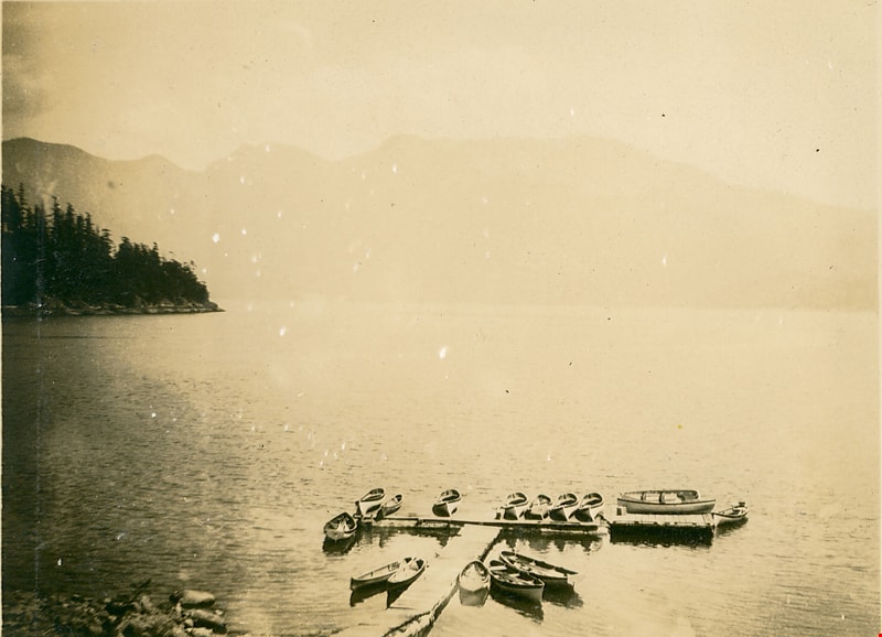
![Horseshoe Bay, [between 1908 and 1911] thumbnail](/media/hpo/_Data/_BVM_Images/1972/1972_0050_0012_001.jpg?width=280)
Horseshoe Bay
https://search.heritageburnaby.ca/link/museumdescription1073
- Repository
- Burnaby Village Museum
- Date
- [between 1908 and 1911]
- Collection/Fonds
- Burnaby Village Museum Photograph collection
- Description Level
- Item
- Physical Description
- 1 photograph : sepia ; 7.4 x 9.9 cm mounted on paper 13.6 x 18.3 cm
- Scope and Content
- Photograph of Horeshoe Bay. People are walking on the beach, swimming, and boating.
- Repository
- Burnaby Village Museum
- Collection/Fonds
- Burnaby Village Museum Photograph collection
- Description Level
- Item
- Physical Description
- 1 photograph : sepia ; 7.4 x 9.9 cm mounted on paper 13.6 x 18.3 cm
- Scope and Content
- Photograph of Horeshoe Bay. People are walking on the beach, swimming, and boating.
- Accession Code
- HV972.50.12
- Access Restriction
- No restrictions
- Reproduction Restriction
- No known restrictions
- Date
- [between 1908 and 1911]
- Media Type
- Photograph
- Scan Resolution
- 600
- Scan Date
- 2023-04-04
- Photographer
- Dean, H.M.
- Notes
- Title based on contents of photograph
Images
![Horseshoe Bay, [between 1908 and 1911] thumbnail](/media/hpo/_Data/_BVM_Images/1972/1972_0050_0012_001.jpg)

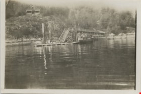
Boat coming through locks
https://search.heritageburnaby.ca/link/museumdescription19435
- Repository
- Burnaby Village Museum
- Date
- 11 Oct. 1936
- Collection/Fonds
- Hawkshaw family fonds
- Description Level
- Item
- Physical Description
- 1 photograph : sepia ; 6.5 x 9 cm
- Scope and Content
- Photograph of a boat towing a log boom and coming through the Hiram M. Chittenden Locks (Ballard Locks) in Salmon Bay in Seattle, Washington's Ship Canal. The locks link Lake Washington to Puget Sound. The Salmon Bay Bridge is visible in the background spanning Salmon Bay.
- Repository
- Burnaby Village Museum
- Collection/Fonds
- Hawkshaw family fonds
- Description Level
- Item
- Physical Description
- 1 photograph : sepia ; 6.5 x 9 cm
- Scope and Content
- Photograph of a boat towing a log boom and coming through the Hiram M. Chittenden Locks (Ballard Locks) in Salmon Bay in Seattle, Washington's Ship Canal. The locks link Lake Washington to Puget Sound. The Salmon Bay Bridge is visible in the background spanning Salmon Bay.
- Subjects
- Transportation - Boats
- Geographic Features - Natural Waterways
- Geographic Features - Channels
- Geographic Features - Bays
- Structures - Bridges
- Water Control
- Accession Code
- BV996.6.119
- Access Restriction
- No restrictions
- Reproduction Restriction
- No known restrictions
- Date
- 11 Oct. 1936
- Media Type
- Photograph
- Scan Resolution
- 600
- Scan Date
- 2023-02-06
- Notes
- Title based on contents of photograph
- Caption beneath photograph reads: "COMING IN"
- Caption of album page reads: "Oct 11/36 / THANKSGIVING / SEATTLE"
- Photograph is part of photograph album BV996.6.1
Images


Government locks opening in Seattle
https://search.heritageburnaby.ca/link/museumdescription19434
- Repository
- Burnaby Village Museum
- Date
- 11 Oct. 1936
- Collection/Fonds
- Hawkshaw family fonds
- Description Level
- Item
- Physical Description
- 1 photograph : sepia ; 6.5 x 9 cm
- Scope and Content
- Photograph of Hiram M. Chittenden Locks (Ballard Locks) opening in Salmon Bay, Seattle, Washington's Ship Canal. The locks are opening to allow a boat to come through. The locks link Lake Washington to Puget Sound. The Salmon Bay Bridge is visible in the background spanning Salmon Bay.
- Repository
- Burnaby Village Museum
- Collection/Fonds
- Hawkshaw family fonds
- Description Level
- Item
- Physical Description
- 1 photograph : sepia ; 6.5 x 9 cm
- Scope and Content
- Photograph of Hiram M. Chittenden Locks (Ballard Locks) opening in Salmon Bay, Seattle, Washington's Ship Canal. The locks are opening to allow a boat to come through. The locks link Lake Washington to Puget Sound. The Salmon Bay Bridge is visible in the background spanning Salmon Bay.
- Subjects
- Transportation - Boats
- Geographic Features - Channels
- Geographic Features - Bays
- Structures - Bridges
- Water Control
- Accession Code
- BV996.6.118
- Access Restriction
- No restrictions
- Reproduction Restriction
- No known restrictions
- Date
- 11 Oct. 1936
- Media Type
- Photograph
- Scan Resolution
- 600
- Scan Date
- 2023-02-06
- Notes
- Title based on contents of photograph
- Caption beneath photograph reads: "GOVT LOCKS SEATTLE / OPENING"
- Caption of album page reads: "Oct 11/36 / THANKSGIVING / SEATTLE"
- Photograph is part of photograph album BV996.6.1
Images

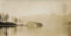
Head Bay, Bowen Island
https://search.heritageburnaby.ca/link/archivedescription34348
- Repository
- City of Burnaby Archives
- Date
- 1927
- Collection/Fonds
- Burnaby Historical Society fonds
- Description Level
- Item
- Physical Description
- 1 photograph : sepia ; 6.2 x 12 cm on page 17.4 x 24.4 cm
- Scope and Content
- Photograph of the rock formation jutting out from Hood Point on Bowen Island, as seen from the water.
- Repository
- City of Burnaby Archives
- Date
- 1927
- Collection/Fonds
- Burnaby Historical Society fonds
- Subseries
- Peers family subseries
- Physical Description
- 1 photograph : sepia ; 6.2 x 12 cm on page 17.4 x 24.4 cm
- Description Level
- Item
- Record No.
- 020-055
- Access Restriction
- No restrictions
- Reproduction Restriction
- No known restrictions
- Accession Number
- BHS2007-04
- Scope and Content
- Photograph of the rock formation jutting out from Hood Point on Bowen Island, as seen from the water.
- Media Type
- Photograph
- Notes
- Title based on caption accompanying photograph
Images
![Unidentified shoreline, [1905] thumbnail](/media/hpo/_Data/_Archives_Images/_Unrestricted/477/477-116.jpg?width=280)
Unidentified shoreline
https://search.heritageburnaby.ca/link/archivedescription38797
- Repository
- City of Burnaby Archives
- Date
- [1905]
- Collection/Fonds
- Peers Family and Hill Family fonds
- Description Level
- Item
- Physical Description
- 1 photograph : sepia ; 5.5 x 5.5 cm on page 11.5 x 14 cm (pasted in album)
- Scope and Content
- Photograph of a pier in the water next to a rocky outcropping, most likely in the Caulfield area of West Vancouver.
- Repository
- City of Burnaby Archives
- Date
- [1905]
- Collection/Fonds
- Peers Family and Hill Family fonds
- Physical Description
- 1 photograph : sepia ; 5.5 x 5.5 cm on page 11.5 x 14 cm (pasted in album)
- Description Level
- Item
- Record No.
- 477-116
- Access Restriction
- No restrictions
- Reproduction Restriction
- No known restrictions
- Accession Number
- 2007-12
- Scope and Content
- Photograph of a pier in the water next to a rocky outcropping, most likely in the Caulfield area of West Vancouver.
- Media Type
- Photograph
- Notes
- Title based on contents of photograph
Images
![Unidentified shoreline, [1905] thumbnail](/media/hpo/_Data/_Archives_Images/_Unrestricted/477/477-116.jpg)
White Rock
https://search.heritageburnaby.ca/link/archivedescription34346
- Repository
- City of Burnaby Archives
- Date
- 1927
- Collection/Fonds
- Burnaby Historical Society fonds
- Description Level
- Item
- Physical Description
- 2 photographs : b&w ; 5.6 x 11.7 cm (pasted together to form panorama) on page 17.5 x 24.4 cm
- Scope and Content
- Photograph of the south half of White Rock as seen from the Pier. Swimmers and other beach-goers are visible in the background as well as the numerous houses overlooking the water.
- Repository
- City of Burnaby Archives
- Date
- 1927
- Collection/Fonds
- Burnaby Historical Society fonds
- Subseries
- Peers family subseries
- Physical Description
- 2 photographs : b&w ; 5.6 x 11.7 cm (pasted together to form panorama) on page 17.5 x 24.4 cm
- Description Level
- Item
- Record No.
- 020-053
- Access Restriction
- No restrictions
- Reproduction Restriction
- No known restrictions
- Accession Number
- BHS2007-04
- Scope and Content
- Photograph of the south half of White Rock as seen from the Pier. Swimmers and other beach-goers are visible in the background as well as the numerous houses overlooking the water.
- Media Type
- Photograph
- Notes
- Title based on contents of photograph
Images

![Hats Off Day, [2001] thumbnail](/media/hpo/_Data/_Archives_Images/_Unrestricted/535/535-3391-5.jpg?width=280)
Hats Off Day
https://search.heritageburnaby.ca/link/archivedescription98381
- Repository
- City of Burnaby Archives
- Date
- [2001]
- Collection/Fonds
- Burnaby NewsLeader photograph collection
- Description Level
- File
- Physical Description
- 10 photographs (tiff) : col.
- Scope and Content
- File contains photographs of the 2001 Hats Off Day parade and event in the Burnaby Heights neighbourhood. Photographs depict performers (including clowns, a town crier, a fire juggler, and tap dancers) in the parade; children and adults enjoying the parade and events; and business owners and volunt…
- Repository
- City of Burnaby Archives
- Date
- [2001]
- Collection/Fonds
- Burnaby NewsLeader photograph collection
- Physical Description
- 10 photographs (tiff) : col.
- Description Level
- File
- Record No.
- 535-3391
- Access Restriction
- No restrictions
- Reproduction Restriction
- No restrictions
- Accession Number
- 2018-12
- Scope and Content
- File contains photographs of the 2001 Hats Off Day parade and event in the Burnaby Heights neighbourhood. Photographs depict performers (including clowns, a town crier, a fire juggler, and tap dancers) in the parade; children and adults enjoying the parade and events; and business owners and volunteers prepping food and dealing with the rainy weather.
- Subjects
- Events
- Events - Parades
- Geographic Features - Neighbourhoods
- Performances
- Persons - Children
- Persons - Crowds
- Media Type
- Photograph
- Notes
- Title based on caption
- Collected by editorial for use in a June 2001 issue of the Burnaby NewsLeader
- Caption from metadata for 535-3391-1: "Kelvin Yee drains the rainwater from the awning in front of the New Rainbow Cafe."
- Caption from metadata for 535-3391-2: "It's hard to stay a happy clown when you're trying to pedal your decorated bike in a rainstorm, as Corey Barker, 8, discovered at Saturday's Hats Off Day parade."
- Caption from metadata for 535-3391-3: "Even the town crier struggled to stay dry during one of the many downpours that rained on Saturday's Hats Off Day parade."
- Caption from metadata for 535-3391-4: "A member of the Confederation Tap Dancers tries to dance up some sunshine at Saturday's Hats Off Day parade."
- Caption from metadata for 535-3391-5: "Devin Schellenberg amazes and delights spectators with his fire juggling at Saturday's Hats Off Day festival."
- Caption from metadata for 535-3391-6: "Ashley Boston, 4, plays in the soap bubbles that appeared at the Heights Fountain Square during Saturday's Hats Off Day festival on Hastings St."
- Caption from metadata for 535-3391-7: "The Hats Off Day parade is all about hats."
- Caption from metadata for 535-3391-8: "Stuart Wells enjoys a salmon kabob outside the Pear Tree Restaurant, some of diverse food being offered by restaurants and delis along Hastings St. as part of Hats Off Day."
- Caption from metadata for 535-3391-9: "George Kopf and Cynthia Chow, of the Footlight Theatre Company, fuel up at the Lions Club pancake breakfast before marching in Saturday's Hats Off Day parade. Kirk Dickson is flipping the pancakes."
- Caption from metadata for 535-3391-10: "Yusef Sulayman, 5, and his sister, Sevda, 6, try to stay dry as they watch Saturday's Hats Off Day parade."
- Geographic Access
- Hastings Street
- Historic Neighbourhood
- Vancouver Heights (Historic Neighbourhood)
- Planning Study Area
- Burnaby Heights Area
Images
![Hats Off Day, [2001] thumbnail](/media/hpo/_Data/_Archives_Images/_Unrestricted/535/535-3391-5.jpg)
![Boats docked at a bay, [between 1908 and 1911] thumbnail](/media/hpo/_Data/_BVM_Images/1972/1972_0050_0014_001.jpg?width=280)
Boats docked at a bay
https://search.heritageburnaby.ca/link/museumdescription1075
- Repository
- Burnaby Village Museum
- Date
- [between 1908 and 1911]
- Collection/Fonds
- Burnaby Village Museum Photograph collection
- Description Level
- Item
- Physical Description
- 1 photograph : b&w ; 7.4 x 9.9 cm mounted on paper 13.6 x 18.3 cm
- Scope and Content
- Photograph of three boats docked at a pier at an unidentified bay.
- Repository
- Burnaby Village Museum
- Collection/Fonds
- Burnaby Village Museum Photograph collection
- Description Level
- Item
- Physical Description
- 1 photograph : b&w ; 7.4 x 9.9 cm mounted on paper 13.6 x 18.3 cm
- Scope and Content
- Photograph of three boats docked at a pier at an unidentified bay.
- Accession Code
- HV972.50.14
- Access Restriction
- No restrictions
- Reproduction Restriction
- No known restrictions
- Date
- [between 1908 and 1911]
- Media Type
- Photograph
- Scan Resolution
- 600
- Scan Date
- 2023-04-04
- Photographer
- Dean, H.M.
- Notes
- Title based on contents of photograph
Images
![Boats docked at a bay, [between 1908 and 1911] thumbnail](/media/hpo/_Data/_BVM_Images/1972/1972_0050_0014_001.jpg)
![Fishermen's Cove, [1927] thumbnail](/media/hpo/_Data/_Archives_Images/_Unrestricted/001/020-146.jpg?width=280)
Fishermen's Cove
https://search.heritageburnaby.ca/link/archivedescription34439
- Repository
- City of Burnaby Archives
- Date
- [1927]
- Collection/Fonds
- Burnaby Historical Society fonds
- Description Level
- Item
- Physical Description
- 1 photograph : b&w ; 5.8 x 12.2 cm on page 17.5 x 26.2 cm
- Scope and Content
- Photograph of a West Vancouver marina with a number of boats alongside a pier and a bridge in the background. The building has "Fishermen's Cove" painted on it.
- Repository
- City of Burnaby Archives
- Date
- [1927]
- Collection/Fonds
- Burnaby Historical Society fonds
- Subseries
- Peers family subseries
- Physical Description
- 1 photograph : b&w ; 5.8 x 12.2 cm on page 17.5 x 26.2 cm
- Description Level
- Item
- Record No.
- 020-146
- Access Restriction
- No restrictions
- Reproduction Restriction
- No known restrictions
- Accession Number
- BHS2007-04
- Scope and Content
- Photograph of a West Vancouver marina with a number of boats alongside a pier and a bridge in the background. The building has "Fishermen's Cove" painted on it.
- Subjects
- Geographic Features - Bays
- Media Type
- Photograph
- Notes
- Title based on contents of photograph
Images
![Fishermen's Cove, [1927] thumbnail](/media/hpo/_Data/_Archives_Images/_Unrestricted/001/020-146.jpg)
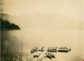
Horseshoe Bay
https://search.heritageburnaby.ca/link/museumdescription1068
- Repository
- Burnaby Village Museum
- Date
- 1910
- Collection/Fonds
- Burnaby Village Museum Photograph collection
- Description Level
- Item
- Physical Description
- 1 photograph : b&w ; 7.5 x 9.9 cm
- Scope and Content
- Photograph of Horeshoe Bay. There are fifteen rowing boats docked at a pier, and mountains are in the background. An annotation on the back of the photograph reads, "Horseshoe Bay / 1910."
- Repository
- Burnaby Village Museum
- Collection/Fonds
- Burnaby Village Museum Photograph collection
- Description Level
- Item
- Physical Description
- 1 photograph : b&w ; 7.5 x 9.9 cm
- Scope and Content
- Photograph of Horeshoe Bay. There are fifteen rowing boats docked at a pier, and mountains are in the background. An annotation on the back of the photograph reads, "Horseshoe Bay / 1910."
- Accession Code
- HV972.50.7
- Access Restriction
- No restrictions
- Reproduction Restriction
- No known restrictions
- Date
- 1910
- Media Type
- Photograph
- Scan Resolution
- 600
- Scan Date
- 2023-04-04
- Photographer
- Dean, H.M.
- Notes
- Title based on contents of photograph
Images
House on hilltop by a pier
https://search.heritageburnaby.ca/link/museumdescription1433
- Repository
- Burnaby Village Museum
- Date
- 1921
- Collection/Fonds
- Burnaby Village Museum Photograph collection
- Description Level
- Item
- Physical Description
- 1 photograph : sepia ; 6 x 9 cm
- Scope and Content
- Photograph a shore with a pier, wooden bridge and stairs leading down to the pier. Close by on the shore is a house built on the top of a hill, overlooking the pier. The inscription on the photograph speculates the location is Williamson's Landing.
- Repository
- Burnaby Village Museum
- Collection/Fonds
- Burnaby Village Museum Photograph collection
- Description Level
- Item
- Physical Description
- 1 photograph : sepia ; 6 x 9 cm
- Material Details
- inscribed in pencil, verso, t. "Williamson's Landing ?/ 1921", stamp, b. [upside down] "340"
- Scope and Content
- Photograph a shore with a pier, wooden bridge and stairs leading down to the pier. Close by on the shore is a house built on the top of a hill, overlooking the pier. The inscription on the photograph speculates the location is Williamson's Landing.
- Accession Code
- BV985.5808.1
- Access Restriction
- No restrictions
- Reproduction Restriction
- No known restrictions
- Date
- 1921
- Media Type
- Photograph
- Scan Resolution
- 600
- Scan Date
- 2024-02-27
- Notes
- Title based on contents of photograph
Images

![Patricia Bay, [1922] thumbnail](/media/hpo/_Data/_Archives_Images/_Unrestricted/477/477-667.jpg?width=280)
Patricia Bay
https://search.heritageburnaby.ca/link/archivedescription39348
- Repository
- City of Burnaby Archives
- Date
- [1922]
- Collection/Fonds
- Peers Family and Hill Family fonds
- Description Level
- Item
- Physical Description
- 1 photograph : b&w ; 6 x 10.6 cm on page 24.5 x 32.5 cm (pasted in album)
- Scope and Content
- Photograph of Patricia Bay on Vancouver Island.
- Repository
- City of Burnaby Archives
- Date
- [1922]
- Collection/Fonds
- Peers Family and Hill Family fonds
- Physical Description
- 1 photograph : b&w ; 6 x 10.6 cm on page 24.5 x 32.5 cm (pasted in album)
- Description Level
- Item
- Record No.
- 477-667
- Access Restriction
- No restrictions
- Reproduction Restriction
- No known restrictions
- Accession Number
- 2007-12
- Scope and Content
- Photograph of Patricia Bay on Vancouver Island.
- Subjects
- Geographic Features - Bays
- Media Type
- Photograph
- Notes
- Title based on caption accompanying photograph
Images
![Patricia Bay, [1922] thumbnail](/media/hpo/_Data/_Archives_Images/_Unrestricted/477/477-667.jpg)
![Yerba Buena to Oakland, [1939] thumbnail](/media/hpo/_Data/_BVM_Images/1985/1985_6114_0128_001.jpg?width=280)
Yerba Buena to Oakland
https://search.heritageburnaby.ca/link/museumdescription1734
- Repository
- Burnaby Village Museum
- Date
- [1939]
- Collection/Fonds
- Burnaby Village Museum Photograph collection
- Description Level
- Item
- Physical Description
- 1 photograph : b&w ; 5.5 x 8 cm
- Scope and Content
- Photograph of the original Eastern span of San Francisco-Oakland Bay Bridge (built in 1936) taken from Treasure Island. The bridge was constructed in five phases: first the East Span, followed by the tunnel through Yerba Buena Island, and then the West span. This was followed by the I-80 West Appro…
- Repository
- Burnaby Village Museum
- Collection/Fonds
- Burnaby Village Museum Photograph collection
- Description Level
- Item
- Physical Description
- 1 photograph : b&w ; 5.5 x 8 cm
- Scope and Content
- Photograph of the original Eastern span of San Francisco-Oakland Bay Bridge (built in 1936) taken from Treasure Island. The bridge was constructed in five phases: first the East Span, followed by the tunnel through Yerba Buena Island, and then the West span. This was followed by the I-80 West Approach and on- and off-ramps, and finally, the Transbay Terminal in San Francisco.
- Accession Code
- BV985.6114.128
- Access Restriction
- No restrictions
- Reproduction Restriction
- No known restrictions
- Date
- [1939]
- Media Type
- Photograph
- Scan Resolution
- 600
- Scan Date
- 2024-04-02
- Notes
- Title based on note written on verso of photograph
- Handwritten note in black ball-point pen on verso of photograph reads: "Yerba Beuna to Oakland"
- Stamp on verso of photograph reads: "653 F"
- Handwritten note in pencil on verso of photograph crosses out "53" and reads: "41"
Images
![Yerba Buena to Oakland, [1939] thumbnail](/media/hpo/_Data/_BVM_Images/1985/1985_6114_0128_001.jpg)
![Beach, [192-] thumbnail](/media/hpo/_Data/_BVM_Images/1976/1976_0036_0022_001.jpg?width=280)
Beach
https://search.heritageburnaby.ca/link/museumdescription660
- Repository
- Burnaby Village Museum
- Date
- [192-]
- Collection/Fonds
- Burnaby Village Museum Photograph collection
- Description Level
- Item
- Physical Description
- 1 photograph : sepia ; 9.8 x 25.4 cm
- Scope and Content
- Photograph of English Bay shoreline, Vancouver populated with people, many of whom are in the water. In view of the photograph, there is a large two-storey building called the Pavillion Bathhouse. Residential housing can be seen along the bank just above the beach as well. There is a paved foot …
- Repository
- Burnaby Village Museum
- Collection/Fonds
- Burnaby Village Museum Photograph collection
- Description Level
- Item
- Physical Description
- 1 photograph : sepia ; 9.8 x 25.4 cm
- Scope and Content
- Photograph of English Bay shoreline, Vancouver populated with people, many of whom are in the water. In view of the photograph, there is a large two-storey building called the Pavillion Bathhouse. Residential housing can be seen along the bank just above the beach as well. There is a paved foot path running along the bank as well. "Marett & Reid Druggists" store can be seen on the left end of the photograph.
- Geographic Access
- Vancouver
- Accession Code
- HV976.36.22
- Access Restriction
- No restrictions
- Reproduction Restriction
- No known restrictions
- Date
- [192-]
- Media Type
- Photograph
- Scan Resolution
- 600
- Scan Date
- 17/8/2006
- Notes
- Title based on contents of photograph
Images
![Beach, [192-] thumbnail](/media/hpo/_Data/_BVM_Images/1976/1976_0036_0022_001.jpg)


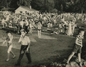
Confederation Park playground
https://search.heritageburnaby.ca/link/archivedescription38667
- Repository
- City of Burnaby Archives
- Date
- 1927
- Collection/Fonds
- Burnaby Historical Society fonds
- Description Level
- Item
- Physical Description
- 1 photograph : b&w ; 19 x 23.5 cm
- Scope and Content
- Photograph of the opening of the Confederation Park playground. A group of children and adults can be seen gathered around and using the swings and slides and other playground equipment. A number of homes on Capitol Hill can be seen in the backgound. Confederation Park opened on June 25, 1927.
- Repository
- City of Burnaby Archives
- Date
- 1927
- Collection/Fonds
- Burnaby Historical Society fonds
- Subseries
- North Burnaby Board of Trade subseries
- Physical Description
- 1 photograph : b&w ; 19 x 23.5 cm
- Description Level
- Item
- Record No.
- 476-010
- Access Restriction
- No restrictions
- Reproduction Restriction
- No known restrictions
- Accession Number
- BHS2005-8
- Scope and Content
- Photograph of the opening of the Confederation Park playground. A group of children and adults can be seen gathered around and using the swings and slides and other playground equipment. A number of homes on Capitol Hill can be seen in the backgound. Confederation Park opened on June 25, 1927.
- Subjects
- Geographic Features - Parks
- Recreational Devices - Playgrounds
- Persons - Crowds
- Events - Openings
- Media Type
- Photograph
- Notes
- Title based on contents of photograph
- Geographic Access
- Confederation Park
- Willingdon Avenue
- Street Address
- 250 Willingdon Avenue
- Historic Neighbourhood
- Capitol Hill (Historic Neighbourhood)
- Planning Study Area
- Capitol Hill Area
Images


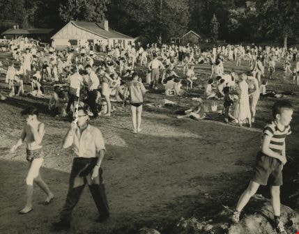
Confederation Park's new playground
https://search.heritageburnaby.ca/link/museumdescription1088
- Repository
- Burnaby Village Museum
- Date
- 1927
- Collection/Fonds
- Burnaby Village Museum Photograph collection
- Description Level
- Item
- Physical Description
- 1 photograph : sepia ; 19 x 23.5 cm
- Scope and Content
- Photograph of a large gathering of adults and children at Confederation Park for the opening ceremony for the new playground. A man on a pedestal is speaking and a crowd of people are surrounding him. There are six women in front of the gazebo wearing tags attached to the front of their dresses tha…
- Repository
- Burnaby Village Museum
- Collection/Fonds
- Burnaby Village Museum Photograph collection
- Description Level
- Item
- Physical Description
- 1 photograph : sepia ; 19 x 23.5 cm
- Scope and Content
- Photograph of a large gathering of adults and children at Confederation Park for the opening ceremony for the new playground. A man on a pedestal is speaking and a crowd of people are surrounding him. There are six women in front of the gazebo wearing tags attached to the front of their dresses that spell out "CANADA". There are three dogs in the foreground playing, and a Union Jack is flying in the upper right corner of the photograph.
- Subjects
- Recreational Devices - Playgrounds
- Geographic Features - Parks
- Persons - Crowds
- Events - Openings
- Geographic Access
- Confederation Park
- Willingdon Avenue
- Street Address
- 250 Willingdon Avenue
- Accession Code
- HV972.51.15
- Access Restriction
- No restrictions
- Reproduction Restriction
- No known restrictions
- Date
- 1927
- Media Type
- Photograph
- Historic Neighbourhood
- Capitol Hill (Historic Neighbourhood)
- Planning Study Area
- Capitol Hill Area
- Scan Resolution
- 600
- Scan Date
- 2023-04-04
- Photographer
- Charlton and Rathburn
- Notes
- Title based on contents of photograph
- Embossed inscription beneath photograph reads: "Charlton and Rathburn. / Vancouver. B.C."
- Handwritten inscription on verso of photograph reads: "Playground opening / Confederation Park / opening of Playground / Confederation Park / about 1927 / JCD on platform speaking"
- 1 b&w copy print accompanying
Images

![Crowd gathered at Sperling Avenue and Douglas Road, [1905] thumbnail](/media/hpo/_Data/_Archives_Images/_Unrestricted/477/477-176.jpg?width=280)
Crowd gathered at Sperling Avenue and Douglas Road
https://search.heritageburnaby.ca/link/archivedescription38857
- Repository
- City of Burnaby Archives
- Date
- [1905]
- Collection/Fonds
- Peers Family and Hill Family fonds
- Description Level
- Item
- Physical Description
- 1 photograph : sepia ; 6 x 10.5 cm on page 14 x 17.5 cm (pasted in album)
- Scope and Content
- Photograph of a crowd of people gathered near the corner of Sperling Avenue and Douglas Road (later Canada Way). A sign in the background reads: "Burnaby By the Lakes Business Sites."
- Repository
- City of Burnaby Archives
- Date
- [1905]
- Collection/Fonds
- Peers Family and Hill Family fonds
- Physical Description
- 1 photograph : sepia ; 6 x 10.5 cm on page 14 x 17.5 cm (pasted in album)
- Description Level
- Item
- Record No.
- 477-176
- Access Restriction
- No restrictions
- Reproduction Restriction
- No known restrictions
- Accession Number
- 2007-12
- Scope and Content
- Photograph of a crowd of people gathered near the corner of Sperling Avenue and Douglas Road (later Canada Way). A sign in the background reads: "Burnaby By the Lakes Business Sites."
- Media Type
- Photograph
- Notes
- Title based on contents of photograph
- Geographic Access
- Douglas Road
- Sperling Avenue
- Canada Way
- Historic Neighbourhood
- Burnaby Lake (Historic Neighbourhood)
- Planning Study Area
- Morley-Buckingham Area
Images
![Crowd gathered at Sperling Avenue and Douglas Road, [1905] thumbnail](/media/hpo/_Data/_Archives_Images/_Unrestricted/477/477-176.jpg)
Deer Lake Park
https://search.heritageburnaby.ca/link/archivedescription34714
- Repository
- City of Burnaby Archives
- Date
- 1958
- Collection/Fonds
- Burnaby Historical Society fonds
- Description Level
- Item
- Physical Description
- 1 photograph : b&w ; 15.2 x 19.5 cm
- Scope and Content
- Photograph of a crowd of men, women and children at a beach at Deer Lake Park.
- Repository
- City of Burnaby Archives
- Date
- 1958
- Collection/Fonds
- Burnaby Historical Society fonds
- Subseries
- Photographs subseries
- Physical Description
- 1 photograph : b&w ; 15.2 x 19.5 cm
- Description Level
- Item
- Record No.
- 117-001
- Access Restriction
- No restrictions
- Reproduction Restriction
- Reproduce for fair dealing purposes only
- Accession Number
- BHS2007-04
- Scope and Content
- Photograph of a crowd of men, women and children at a beach at Deer Lake Park.
- Media Type
- Photograph
- Photographer
- King, Basil
- Notes
- Title based on contents of photograph
- Stamp on back of photo reads, "Basil King Photo"
- Geographic Access
- Deer Lake Park
- Deer Lake Avenue
- Deer Lake
- Historic Neighbourhood
- Burnaby Lake (Historic Neighbourhood)
- Planning Study Area
- Oakalla Area
- Morley-Buckingham Area
Images

Deer Lake Park
https://search.heritageburnaby.ca/link/archivedescription34715
- Repository
- City of Burnaby Archives
- Date
- 1958
- Collection/Fonds
- Burnaby Historical Society fonds
- Description Level
- Item
- Physical Description
- 1 photograph : b&w ; 10.5 x 19.5 cm
- Scope and Content
- Photograph of a crowd on a beach and in the water at Deer Lake Park. Cars are parked in the foreground.
- Repository
- City of Burnaby Archives
- Date
- 1958
- Collection/Fonds
- Burnaby Historical Society fonds
- Subseries
- Photographs subseries
- Physical Description
- 1 photograph : b&w ; 10.5 x 19.5 cm
- Description Level
- Item
- Record No.
- 117-002
- Access Restriction
- No restrictions
- Reproduction Restriction
- Reproduce for fair dealing purposes only
- Accession Number
- BHS2007-04
- Scope and Content
- Photograph of a crowd on a beach and in the water at Deer Lake Park. Cars are parked in the foreground.
- Media Type
- Photograph
- Photographer
- King, Basil
- Notes
- Title based on contents of photograph
- Geographic Access
- Deer Lake Park
- Deer Lake Avenue
- Deer Lake
- Historic Neighbourhood
- Burnaby Lake (Historic Neighbourhood)
- Planning Study Area
- Oakalla Area
- Morley-Buckingham Area
Images

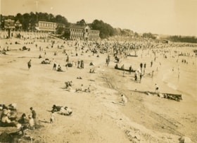
English Bay, Vancouver
https://search.heritageburnaby.ca/link/museumdescription1072
- Repository
- Burnaby Village Museum
- Date
- 1911
- Collection/Fonds
- Burnaby Village Museum Photograph collection
- Description Level
- Item
- Physical Description
- 1 photograph : b&w ; 7.3 x 9.9 cm
- Scope and Content
- Photograph of the beach at English Bay, Vancouver. The beach is crowded an buildings can be seen in the background.
- Repository
- Burnaby Village Museum
- Collection/Fonds
- Burnaby Village Museum Photograph collection
- Description Level
- Item
- Physical Description
- 1 photograph : b&w ; 7.3 x 9.9 cm
- Scope and Content
- Photograph of the beach at English Bay, Vancouver. The beach is crowded an buildings can be seen in the background.
- Geographic Access
- Vancouver
- Accession Code
- HV972.50.11
- Access Restriction
- No restrictions
- Reproduction Restriction
- No known restrictions
- Date
- 1911
- Media Type
- Photograph
- Scan Resolution
- 600
- Scan Date
- 2023-04-04
- Photographer
- Dean, H.M.
- Notes
- Title based on contents of photograph
- Annotation on verso of photograph reads: "English Bay/ 1911."
Images
