More like 'Bottle'
Narrow Results By
Subject
- Agricultural Tools and Equipment - Gardening Equipment 1
- Animals 1
- Animals - Birds 1
- Armament - Firearms 1
- Armament Tools and Equipment (Firearm) 1
- Arts - Sculptures 2
- Buildings - Civic - Art Galleries 2
- Buildings - Civic - Hospitals 4
- Buildings - Civic - Libraries 1
- Buildings - Civic - Seniors Centres 1
- Buildings - Commercial - Restaurants 1
- Buildings - Industrial 1

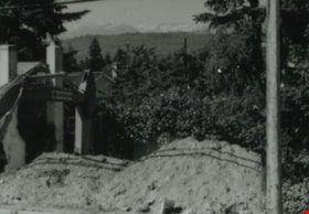
1982 - Moving the Roberts House
https://search.heritageburnaby.ca/link/archivedescription91887
- Repository
- City of Burnaby Archives
- Date
- September 1982
- Collection/Fonds
- Small family fonds
- Description Level
- Item
- Physical Description
- 1 photograph : col. ; 10 cm x 15 cm
- Scope and Content
- Photograph of the Roberts' house in its new position at 5496 Dominion Street. The house is jacked up and sitting on block to enable workers to build forms and pour concrete for the foundation walls.
- Repository
- City of Burnaby Archives
- Date
- September 1982
- Collection/Fonds
- Small family fonds
- Physical Description
- 1 photograph : col. ; 10 cm x 15 cm
- Description Level
- Item
- Record No.
- 620-068
- Access Restriction
- No restrictions
- Reproduction Restriction
- No reproduction permitted
- Accession Number
- 2017-01
- Scope and Content
- Photograph of the Roberts' house in its new position at 5496 Dominion Street. The house is jacked up and sitting on block to enable workers to build forms and pour concrete for the foundation walls.
- Media Type
- Photograph
- Notes
- Transcribed title
- Title transcribed from donor's notes
- Note in blue ink on verso of photograph reads: "P.10"
- Note in black ink on verso of photograph reads: "15"
- Note in pencil on verso of photograph reads: "9"
- Note in black ink on verso of photograph reads: "Moving the house / Foundation Built, Waterproofed and Drainage Installed. / Sept. 82"
- Street Address
- 5496 Dominion Street
- Historic Neighbourhood
- Burnaby Lake (Historic Neighbourhood)
- Planning Study Area
- Ardingley-Sprott Area
Images


1982 - Moving the Roberts House
https://search.heritageburnaby.ca/link/archivedescription91891
- Repository
- City of Burnaby Archives
- Date
- 1982
- Collection/Fonds
- Small family fonds
- Description Level
- Item
- Physical Description
- 1 photograph : col. ; 10 cm x 15 cm
- Scope and Content
- Photograph of an excavator clearing the land between 5496 Dominion Street and Douglas Road. The three lots in this area were subdivided into six 33 foot lots and cleared for the construction of six new houses.
- Repository
- City of Burnaby Archives
- Date
- 1982
- Collection/Fonds
- Small family fonds
- Physical Description
- 1 photograph : col. ; 10 cm x 15 cm
- Description Level
- Item
- Record No.
- 620-072
- Access Restriction
- No restrictions
- Reproduction Restriction
- No reproduction permitted
- Accession Number
- 2017-01
- Scope and Content
- Photograph of an excavator clearing the land between 5496 Dominion Street and Douglas Road. The three lots in this area were subdivided into six 33 foot lots and cleared for the construction of six new houses.
- Media Type
- Photograph
- Notes
- Transcribed title
- Title transcribed from donor's notes
- Note in blue ink on verso of photograph reads: "P.14"
- Note in pencil on verso of photograph reads: "13"
- Street Address
- 5496 Dominion Street
- Historic Neighbourhood
- Burnaby Lake (Historic Neighbourhood)
- Planning Study Area
- Ardingley-Sprott Area
Images


1982 - Moving the Roberts House
https://search.heritageburnaby.ca/link/archivedescription91892
- Repository
- City of Burnaby Archives
- Date
- 1982
- Collection/Fonds
- Small family fonds
- Description Level
- Item
- Physical Description
- 1 photograph : col. ; 15 cm x 10 cm
- Scope and Content
- Photograph of a labourer removing the old foundation and boulders from the 5496 Dominion Street property with a jackhammer. The house located at 5511 Norfolk Street is visible in the background.
- Repository
- City of Burnaby Archives
- Date
- 1982
- Collection/Fonds
- Small family fonds
- Physical Description
- 1 photograph : col. ; 15 cm x 10 cm
- Description Level
- Item
- Record No.
- 620-073
- Access Restriction
- No restrictions
- Reproduction Restriction
- No reproduction permitted
- Accession Number
- 2017-01
- Scope and Content
- Photograph of a labourer removing the old foundation and boulders from the 5496 Dominion Street property with a jackhammer. The house located at 5511 Norfolk Street is visible in the background.
- Media Type
- Photograph
- Notes
- Transcribed title
- Title transcribed from donor's notes
- Note in blue ink on verso of photograph reads: "P.15"
- Note in pencil on verso of photograph reads: "14"
- 5511 Norfolk Street was previously numbered 3149 Norfolk Street. It was later subdivided into two lots: 5503 and 5521 Norfolk Street.
- Street Address
- 5511 Norfolk Street
- 5496 Dominion Street
- Historic Neighbourhood
- Burnaby Lake (Historic Neighbourhood)
- Planning Study Area
- Ardingley-Sprott Area
Images

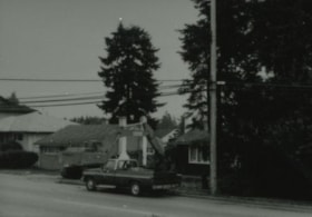
6742 Walker Avenue demolition
https://search.heritageburnaby.ca/link/archivedescription37847
- Repository
- City of Burnaby Archives
- Date
- June 5, 1987 (date of original), copied 1991
- Collection/Fonds
- Burnaby Historical Society fonds
- Description Level
- Item
- Physical Description
- 1 photograph : b&w ; 3.0 x 4.4 cm print on contact sheet 20.6 x 26.7 cm
- Scope and Content
- Photograph of a truck and back hoe at 6742 Walker Avenue at 7:30am on June 5, 1987. The house in in the process of being demolished.
- Repository
- City of Burnaby Archives
- Date
- June 5, 1987 (date of original), copied 1991
- Collection/Fonds
- Burnaby Historical Society fonds
- Subseries
- Burnaby Image Bank subseries
- Physical Description
- 1 photograph : b&w ; 3.0 x 4.4 cm print on contact sheet 20.6 x 26.7 cm
- Description Level
- Item
- Record No.
- 370-435
- Access Restriction
- No restrictions
- Reproduction Restriction
- No restrictions
- Accession Number
- BHS1999-03
- Scope and Content
- Photograph of a truck and back hoe at 6742 Walker Avenue at 7:30am on June 5, 1987. The house in in the process of being demolished.
- Media Type
- Photograph
- Notes
- Title based on contents of photograph
- 1 b&w copy negative accompanying
- Negative has a pink cast
- Copied from col. photograph
- Geographic Access
- Walker Avenue
- Street Address
- 6742 Walker Avenue
- Historic Neighbourhood
- Edmonds (Historic Neighbourhood)
- Planning Study Area
- Richmond Park Area
Images
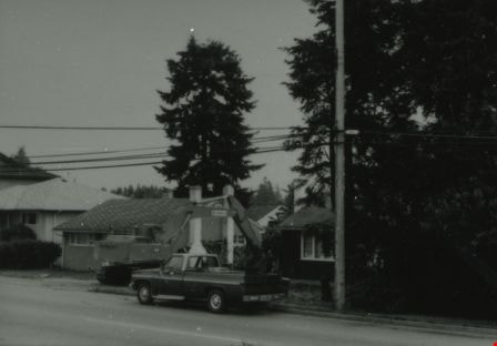

6742 Walker Avenue demolition
https://search.heritageburnaby.ca/link/archivedescription37848
- Repository
- City of Burnaby Archives
- Date
- June 5, 1987 (date of original), copied 1991
- Collection/Fonds
- Burnaby Historical Society fonds
- Description Level
- Item
- Physical Description
- 1 photograph : b&w ; 3.0 x 4.4 cm print on contact sheet 20.6 x 26.7 cm
- Scope and Content
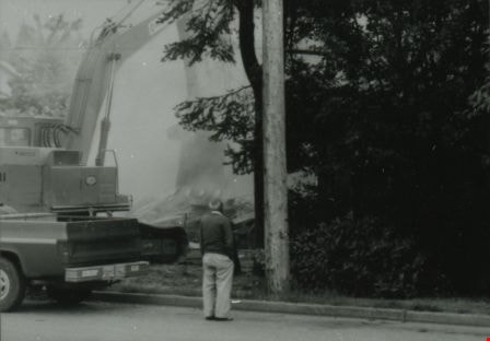
- Photograph of a truck and back hoe at 6742 Walker Avenue on June 5, 1987. The house in in the process of being demolished and a man is looking on.
- Repository
- City of Burnaby Archives
- Date
- June 5, 1987 (date of original), copied 1991
- Collection/Fonds
- Burnaby Historical Society fonds
- Subseries
- Burnaby Image Bank subseries
- Physical Description
- 1 photograph : b&w ; 3.0 x 4.4 cm print on contact sheet 20.6 x 26.7 cm
- Description Level
- Item
- Record No.
- 370-436
- Access Restriction
- No restrictions
- Reproduction Restriction
- No restrictions
- Accession Number
- BHS1999-03
- Scope and Content
- Photograph of a truck and back hoe at 6742 Walker Avenue on June 5, 1987. The house in in the process of being demolished and a man is looking on.
- Media Type
- Photograph
- Notes
- Title based on contents of photograph
- 1 b&w copy negative accompanying
- Negative has a pink cast
- Copied from col. photograph
- Geographic Access
- Walker Avenue
- Street Address
- 6742 Walker Avenue
- Historic Neighbourhood
- Edmonds (Historic Neighbourhood)
- Planning Study Area
- Richmond Park Area
Images
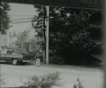
6742 Walker Avenue demolition
https://search.heritageburnaby.ca/link/archivedescription37849
- Repository
- City of Burnaby Archives
- Date
- June 5, 1987 (date of original), copied 1991
- Collection/Fonds
- Burnaby Historical Society fonds
- Description Level
- Item
- Physical Description
- 1 photograph : b&w ; 3.0 x 4.3 cm print on contact sheet 20.6 x 26.7 cm
- Scope and Content
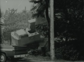
- Photograph of a truck and back hoe at 6742 Walker Avenue. The house in in the process of being demolished, and a man is looking on.
- Repository
- City of Burnaby Archives
- Date
- June 5, 1987 (date of original), copied 1991
- Collection/Fonds
- Burnaby Historical Society fonds
- Subseries
- Burnaby Image Bank subseries
- Physical Description
- 1 photograph : b&w ; 3.0 x 4.3 cm print on contact sheet 20.6 x 26.7 cm
- Description Level
- Item
- Record No.
- 370-437
- Access Restriction
- No restrictions
- Reproduction Restriction
- No restrictions
- Accession Number
- BHS1999-03
- Scope and Content
- Photograph of a truck and back hoe at 6742 Walker Avenue. The house in in the process of being demolished, and a man is looking on.
- Subjects
- Construction Tools and Equipment
- Media Type
- Photograph
- Notes
- Title based on contents of photograph
- 1 b&w copy negative accompanying
- Negative has a pink cast
- Copied from col. photograph
- Geographic Access
- Walker Avenue
- Street Address
- 6742 Walker Avenue
- Historic Neighbourhood
- Edmonds (Historic Neighbourhood)
- Planning Study Area
- Richmond Park Area
Images
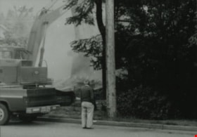
6742 Walker Avenue demolition
https://search.heritageburnaby.ca/link/archivedescription37850
- Repository
- City of Burnaby Archives
- Date
- June 5, 1987 (date of original), copied 1991
- Collection/Fonds
- Burnaby Historical Society fonds
- Description Level
- Item
- Physical Description
- 1 photograph : b&w ; 3.0 x 4.3 cm print on contact sheet 20.6 x 26.7 cm
- Scope and Content
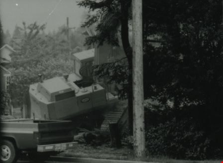
- Photograph of a truck and back hoe at 6742 Walker Avenue. The house in in the process of being demolished.
- Repository
- City of Burnaby Archives
- Date
- June 5, 1987 (date of original), copied 1991
- Collection/Fonds
- Burnaby Historical Society fonds
- Subseries
- Burnaby Image Bank subseries
- Physical Description
- 1 photograph : b&w ; 3.0 x 4.3 cm print on contact sheet 20.6 x 26.7 cm
- Description Level
- Item
- Record No.
- 370-438
- Access Restriction
- No restrictions
- Reproduction Restriction
- No restrictions
- Accession Number
- BHS1999-03
- Scope and Content
- Photograph of a truck and back hoe at 6742 Walker Avenue. The house in in the process of being demolished.
- Subjects
- Construction Tools and Equipment
- Media Type
- Photograph
- Notes
- Title based on contents of photograph
- 1 b&w copy negative accompanying
- Negative has a pink cast
- Copied from col. photograph
- Geographic Access
- Walker Avenue
- Street Address
- 6742 Walker Avenue
- Historic Neighbourhood
- Edmonds (Historic Neighbourhood)
- Planning Study Area
- Richmond Park Area
Images
6742 Walker Avenue demolition
https://search.heritageburnaby.ca/link/archivedescription37851
- Repository
- City of Burnaby Archives
- Date
- June 5, 1987 (date of original), copied 1991
- Collection/Fonds
- Burnaby Historical Society fonds
- Description Level
- Item
- Physical Description
- 1 photograph : b&w ; 3.0 x 4.3 cm print on contact sheet 20.6 x 26.7 cm
- Scope and Content
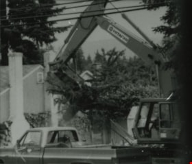
- Photograph of a truck and back hoe at 6742 Walker Avenue. The house in in the process of being demolished.
- Repository
- City of Burnaby Archives
- Date
- June 5, 1987 (date of original), copied 1991
- Collection/Fonds
- Burnaby Historical Society fonds
- Subseries
- Burnaby Image Bank subseries
- Physical Description
- 1 photograph : b&w ; 3.0 x 4.3 cm print on contact sheet 20.6 x 26.7 cm
- Description Level
- Item
- Record No.
- 370-439
- Access Restriction
- No restrictions
- Reproduction Restriction
- No restrictions
- Accession Number
- BHS1999-03
- Scope and Content
- Photograph of a truck and back hoe at 6742 Walker Avenue. The house in in the process of being demolished.
- Subjects
- Construction Tools and Equipment
- Media Type
- Photograph
- Notes
- Title based on contents of photograph
- 1 b&w copy negative accompanying
- Negative has a pink cast
- Copied from col. photograph
- Geographic Access
- Walker Avenue
- Street Address
- 6742 Walker Avenue
- Historic Neighbourhood
- Edmonds (Historic Neighbourhood)
- Planning Study Area
- Richmond Park Area
Images

6742 Walker Avenue demolition
https://search.heritageburnaby.ca/link/archivedescription37852
- Repository
- City of Burnaby Archives
- Date
- June 5, 1987 (date of original), copied 1991
- Collection/Fonds
- Burnaby Historical Society fonds
- Description Level
- Item
- Physical Description
- 1 photograph : b&w ; 3.0 x 4.3 cm print on contact sheet 20.6 x 26.7 cm
- Scope and Content
- Photograph of a foundation hole being dug for a house at 6742 Walker Avenue at 4:00pm on June 5, 1987.
- Repository
- City of Burnaby Archives
- Date
- June 5, 1987 (date of original), copied 1991
- Collection/Fonds
- Burnaby Historical Society fonds
- Subseries
- Burnaby Image Bank subseries
- Physical Description
- 1 photograph : b&w ; 3.0 x 4.3 cm print on contact sheet 20.6 x 26.7 cm
- Description Level
- Item
- Record No.
- 370-440
- Access Restriction
- No restrictions
- Reproduction Restriction
- No restrictions
- Accession Number
- BHS1999-03
- Scope and Content
- Photograph of a foundation hole being dug for a house at 6742 Walker Avenue at 4:00pm on June 5, 1987.
- Subjects
- Construction Tools and Equipment
- Media Type
- Photograph
- Notes
- Title based on contents of photograph
- 1 b&w copy negative accompanying
- Negative has a pink cast
- Copied from col. photograph
- Geographic Access
- Walker Avenue
- Street Address
- 6742 Walker Avenue
- Historic Neighbourhood
- Edmonds (Historic Neighbourhood)
- Planning Study Area
- Richmond Park Area
Images

6850 20th Avenue
https://search.heritageburnaby.ca/link/archivedescription93728
- Repository
- City of Burnaby Archives
- Date
- March 1989
- Collection/Fonds
- Grover, Elliott & Co. Ltd. fonds
- Description Level
- File
- Physical Description
- 31 photographs : col. negatives ; 35 mm
- Scope and Content
- Photographs of an industrial property located at 6850 20th Avenue during construction. 6850 20th Avenue is an address that no longer exists.
- Repository
- City of Burnaby Archives
- Date
- March 1989
- Collection/Fonds
- Grover, Elliott & Co. Ltd. fonds
- Physical Description
- 31 photographs : col. negatives ; 35 mm
- Description Level
- File
- Record No.
- 622-016
- Access Restriction
- No restrictions
- Reproduction Restriction
- No restrictions
- Accession Number
- 2017-39
- Scope and Content
- Photographs of an industrial property located at 6850 20th Avenue during construction. 6850 20th Avenue is an address that no longer exists.
- Media Type
- Photograph
- Notes
- Transcribed title
- Title transcribed from original print envelope
- Geographic Access
- 20th Avenue
- Planning Study Area
- Stride Hill Area
8575 Government Street
https://search.heritageburnaby.ca/link/archivedescription93738
- Repository
- City of Burnaby Archives
- Date
- March 1989
- Collection/Fonds
- Grover, Elliott & Co. Ltd. fonds
- Description Level
- File
- Physical Description
- 4 photographs : col. ; 10 cm x 15 cm
- Scope and Content
- Photographs of the industrial complex located at 8575 Government Street under construction.
- Repository
- City of Burnaby Archives
- Date
- March 1989
- Collection/Fonds
- Grover, Elliott & Co. Ltd. fonds
- Physical Description
- 4 photographs : col. ; 10 cm x 15 cm
- Description Level
- File
- Record No.
- 622-023
- Access Restriction
- No restrictions
- Reproduction Restriction
- No restrictions
- Accession Number
- 2017-39
- Scope and Content
- Photographs of the industrial complex located at 8575 Government Street under construction.
- Media Type
- Photograph
- Notes
- Transcribed title
- Title transcribed from sticky note adhered to photograph 622-023-1
- File no. 89-125-B
- Photograph 622-023-1 caption reads: "View north from Government Street"
- Photograph 622-023-2 caption reads: "Eastern view along Government Street; Note Gaglardi Way overpass"
- Photograph 622-023-3 caption reads: "Rear of building"
- Photograph 622-023-4 caption reads: "Southern view along main facade"
- Photograph captions transcribed from the paper on which the photographs were originally adhered.
- Geographic Access
- Government Street
- Street Address
- 8575 Government Street
- Planning Study Area
- Lake City Area
8855 Northbrook Court
https://search.heritageburnaby.ca/link/archivedescription93735
- Repository
- City of Burnaby Archives
- Date
- 1989
- Collection/Fonds
- Grover, Elliott & Co. Ltd. fonds
- Description Level
- File
- Physical Description
- 21 photographs : col. negatives ; 35 mm
- Scope and Content
- Photographs of an undeveloped property loacated at 8855 Northbrook Court. Construction equipment is visible in the distance.
- Repository
- City of Burnaby Archives
- Date
- 1989
- Collection/Fonds
- Grover, Elliott & Co. Ltd. fonds
- Physical Description
- 21 photographs : col. negatives ; 35 mm
- Description Level
- File
- Record No.
- 622-020
- Access Restriction
- No restrictions
- Reproduction Restriction
- No restrictions
- Accession Number
- 2017-39
- Scope and Content
- Photographs of an undeveloped property loacated at 8855 Northbrook Court. Construction equipment is visible in the distance.
- Media Type
- Photograph
- Notes
- Transcribed title
- Title transcribed from original print envelope
- File no. 89-037-B
- Geographic Access
- Northbrook Court
- Street Address
- 8855 Northbrook Court
- Historic Neighbourhood
- Fraser Arm (Historic Neighbourhood)
- Planning Study Area
- Big Bend Area

ALRT - Night Tour
https://search.heritageburnaby.ca/link/archivedescription91714
- Repository
- City of Burnaby Archives
- Date
- February 1984
- Collection/Fonds
- Doreen Lawson fonds
- Description Level
- File
- Physical Description
- 40 photographs : col. slides ; 35 mm
- Scope and Content
- File consists of photographs of Johnson Terminal drivers hauling Advanced Light Rapid Transit (ALRT) rail beds from Delta, BC to Burnaby, BC. Rail beds are lowered onto trucks, driven overnight to Burnaby, and installed onto tall cement supports via cranes to create elevated guideways for the SkyT…
- Repository
- City of Burnaby Archives
- Date
- February 1984
- Collection/Fonds
- Doreen Lawson fonds
- Physical Description
- 40 photographs : col. slides ; 35 mm
- Description Level
- File
- Record No.
- 618-032
- Access Restriction
- No restrictions
- Reproduction Restriction
- No restrictions
- Accession Number
- 2015-15
- Scope and Content
- File consists of photographs of Johnson Terminal drivers hauling Advanced Light Rapid Transit (ALRT) rail beds from Delta, BC to Burnaby, BC. Rail beds are lowered onto trucks, driven overnight to Burnaby, and installed onto tall cement supports via cranes to create elevated guideways for the SkyTrain system.
- Media Type
- Photograph
- Photographer
- Lawson, Doreen A.
- Notes
- Transcribed title
- Title transcribed from label on original slide cases
- Note in blue ink on card slotted into slide pocket on slide sheet reads: "Exerpts [sic] from an all night ride from Delta to Burnaby with Johnson Terminal drivers hauling ALRT rail beds. / 1984"
Images

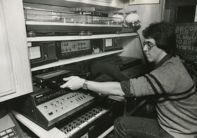
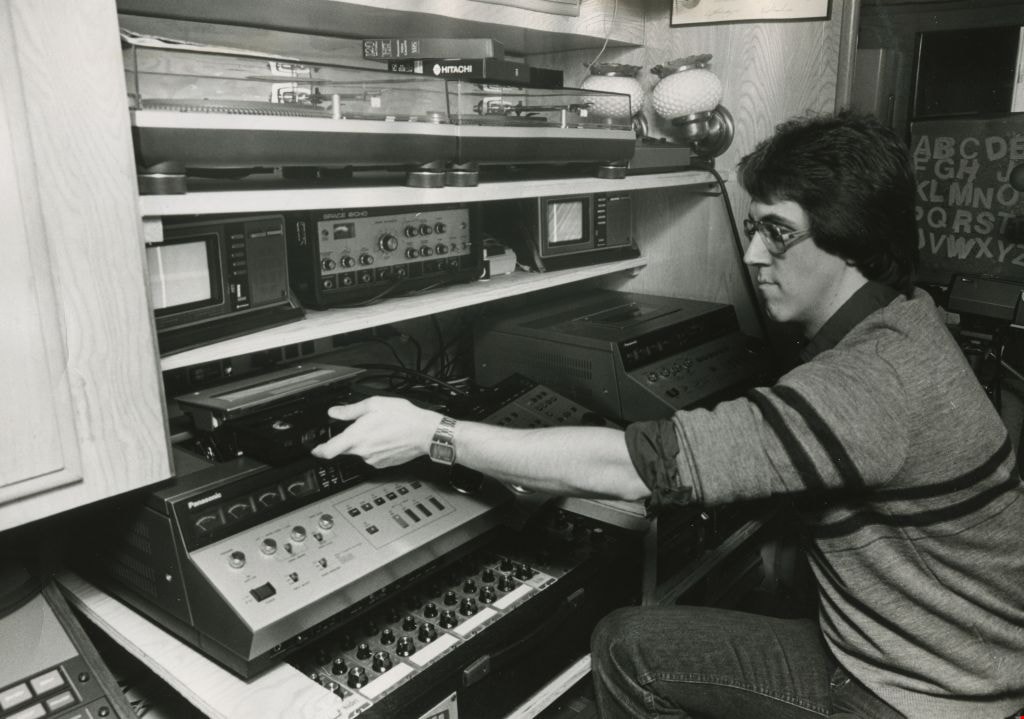
A man in a recording studio
https://search.heritageburnaby.ca/link/archivedescription59041
- Repository
- City of Burnaby Archives
- Date
- ca.1983
- Collection/Fonds
- Columbian Newspaper collection
- Description Level
- Item
- Physical Description
- 1 photograph : b&w ; 18.5 x 25.5 cm
- Scope and Content
- Photograph of a man in a studio with audiovisual equipment. He is placing a VHS tape into an editing device.
- Repository
- City of Burnaby Archives
- Date
- ca.1983
- Collection/Fonds
- Columbian Newspaper collection
- Physical Description
- 1 photograph : b&w ; 18.5 x 25.5 cm
- Description Level
- Item
- Record No.
- 480-1447
- Access Restriction
- No restrictions
- Reproduction Restriction
- Reproduce for fair dealing purposes only
- Accession Number
- 2009-01
- Scope and Content
- Photograph of a man in a studio with audiovisual equipment. He is placing a VHS tape into an editing device.
- Media Type
- Photograph
- Photographer
- Hodge, Craig
- Notes
- Title based on contents of photograph
- Photographer's stamp on verso
- Note on verso reads: "page 6 / Burnaby / Today / PMT 100%"
Images
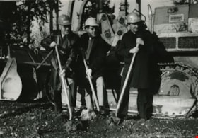
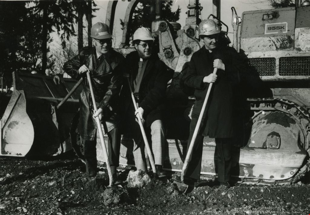
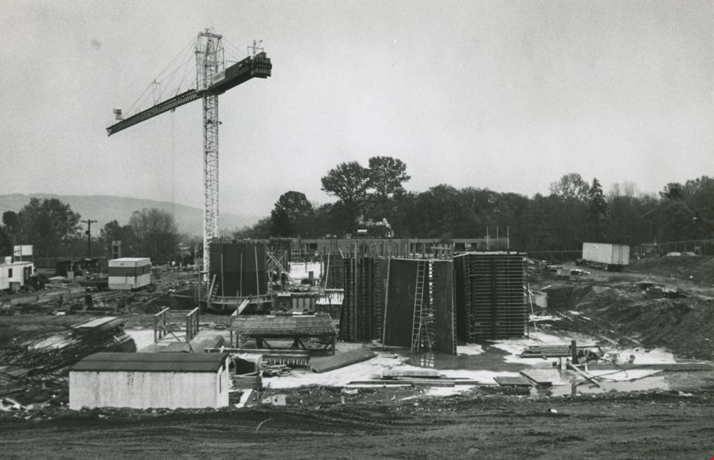
Construction of the St. Michael's Centre
https://search.heritageburnaby.ca/link/archivedescription45354
- Repository
- City of Burnaby Archives
- Date
- January 1980
- Collection/Fonds
- Columbian Newspaper collection
- Description Level
- Item
- Physical Description
- 1 photograph : b&w ; 16.5 x 24 cm
- Scope and Content
- Photograph of Reverend George Morrison of the United Church, Reverend Donald Grayson of the Anglican Church, and Father Dennis Luterback of the Catholic Church with hard hats on and shovels in their hands. They were participating in the sod turning ceremony for the then new combined care facility f…
- Repository
- City of Burnaby Archives
- Date
- January 1980
- Collection/Fonds
- Columbian Newspaper collection
- Physical Description
- 1 photograph : b&w ; 16.5 x 24 cm
- Description Level
- Item
- Record No.
- 480-249
- Access Restriction
- No restrictions
- Reproduction Restriction
- Reproduce for fair dealing purposes only
- Accession Number
- 2003-02
- Scope and Content
- Photograph of Reverend George Morrison of the United Church, Reverend Donald Grayson of the Anglican Church, and Father Dennis Luterback of the Catholic Church with hard hats on and shovels in their hands. They were participating in the sod turning ceremony for the then new combined care facility for seniors being built by St. Michael's Centre Society in South Burnaby.
- Names
- St. Michael's Centre Extended Care and Hospice Facility
- Morrison, Reverend George
- Grayson, Reverend Donald
- Luterback, Father Dennis
- Media Type
- Photograph
- Notes
- Title based on contents of photograph
- Newspaper clipping attached to verso of photograph reads: "DIGGING IN ... Sod turning ceremony for new 80-bed combined care facility for seniors being built by St. Michael's Centre Society was held recently. Participating in ceremony were, from left to right, Rev. George Morrison of United Church, Rev. Donald Grayson of Anglican Church, and Father Dennis Luterback of Catholic Church."
- Geographic Access
- Sussex Avenue
- Street Address
- 7451 Sussex Avenue
- Historic Neighbourhood
- Alta-Vista (Historic Neighbourhood)
- Planning Study Area
- Sussex-Nelson Area
Images
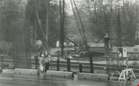
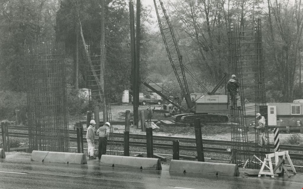
Construction workers
https://search.heritageburnaby.ca/link/archivedescription59066
- Repository
- City of Burnaby Archives
- Date
- ca.1983
- Collection/Fonds
- Columbian Newspaper collection
- Description Level
- Item
- Physical Description
- 1 photograph : b&w ; 17 x 25.5 cm
- Scope and Content
- Photograph of construction workers erecting steel frames next to railway tracks. Cranes and other construction vehicles are in the background.
- Repository
- City of Burnaby Archives
- Date
- ca.1983
- Collection/Fonds
- Columbian Newspaper collection
- Physical Description
- 1 photograph : b&w ; 17 x 25.5 cm
- Description Level
- Item
- Record No.
- 480-1472
- Access Restriction
- No restrictions
- Reproduction Restriction
- Reproduce for fair dealing purposes only
- Accession Number
- 2009-01
- Scope and Content
- Photograph of construction workers erecting steel frames next to railway tracks. Cranes and other construction vehicles are in the background.
- Media Type
- Photograph
- Photographer
- Hodge, Craig
- Notes
- Title based on contents of photograph
- Photographer's stamp on verso
- Note on verso reads: "PMT 100% / Page 4 / Burnaby / Today"
Images
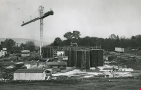
Construction work zone
https://search.heritageburnaby.ca/link/archivedescription59179
- Repository
- City of Burnaby Archives
- Date
- ca.1982
- Collection/Fonds
- Columbian Newspaper collection
- Description Level
- Item
- Physical Description
- 1 photograph : b&w ; 17.5 x 24 cm
- Scope and Content
- Photograph of a construction site, including the frame of a building and a crane.
- Repository
- City of Burnaby Archives
- Date
- ca.1982
- Collection/Fonds
- Columbian Newspaper collection
- Physical Description
- 1 photograph : b&w ; 17.5 x 24 cm
- Description Level
- Item
- Record No.
- 480-1502
- Access Restriction
- No restrictions
- Reproduction Restriction
- Reproduce for fair dealing purposes only
- Accession Number
- 2009-01
- Scope and Content
- Photograph of a construction site, including the frame of a building and a crane.
- Media Type
- Photograph
- Photographer
- King, Basil
- Notes
- Title based on contents of photograph
- Photographer's stamp on verso
- Note on verso reads: "Page 4 / Burnaby Today / PMT 100%"
Images

Former site of the Kelly Douglas building
https://search.heritageburnaby.ca/link/archivedescription35027
- Repository
- City of Burnaby Archives
- Date
- August 18, 1986
- Collection/Fonds
- Burnaby Historical Society fonds
- Description Level
- Item
- Physical Description
- 1 photograph : col. ; 8.8 x 12.6 cm
- Scope and Content
- Photograph of the site of Kelly Douglas and Co. at 4700 Kingsway after the building was demolished. A bulldozer and a large truck with two men standing on it are at the back left of the photograph.
- Repository
- City of Burnaby Archives
- Date
- August 18, 1986
- Collection/Fonds
- Burnaby Historical Society fonds
- Subseries
- Evelyn Salisbury subseries
- Physical Description
- 1 photograph : col. ; 8.8 x 12.6 cm
- Material Details
- Printed on verso of photograph: "This paper manufactured by Kodak"
- Description Level
- Item
- Record No.
- 178-001
- Access Restriction
- No restrictions
- Reproduction Restriction
- Reproduce for fair dealing purposes only
- Accession Number
- BHS1986-26
- Scope and Content
- Photograph of the site of Kelly Douglas and Co. at 4700 Kingsway after the building was demolished. A bulldozer and a large truck with two men standing on it are at the back left of the photograph.
- Media Type
- Photograph
- Notes
- Title based on contents of photograph
- Geographic Access
- Kingsway
- Street Address
- 4700 Kingsway
- Historic Neighbourhood
- Central Park (Historic Neighbourhood)
- Planning Study Area
- Maywood Area
Images

![Framed panel of weapons and firing stances used in firearms training, [198-] thumbnail](/media/hpo/_Data/_BVM_Images/1991/1991_0045_0044_002.jpg?width=280)
Framed panel of weapons and firing stances used in firearms training
https://search.heritageburnaby.ca/link/museumdescription1115
- Repository
- Burnaby Village Museum
- Date
- [198-]
- Collection/Fonds
- Oakalla Prison collection
- Description Level
- Item
- Physical Description
- 1 photograph (tiff) ; 240 dpi
- Scope and Content
- Item consists of a documentation photograph of a framed panel of fourteen photographs of an unidentified correctional officer demonstrating weapon and firing stances used in firearms training. Photographs within panel are arranged in three rows with various positions of stances identified under eac…
- Repository
- Burnaby Village Museum
- Collection/Fonds
- Oakalla Prison collection
- Description Level
- Item
- Physical Description
- 1 photograph (tiff) ; 240 dpi
- Scope and Content
- Item consists of a documentation photograph of a framed panel of fourteen photographs of an unidentified correctional officer demonstrating weapon and firing stances used in firearms training. Photographs within panel are arranged in three rows with various positions of stances identified under each (from left to right, top row) "Port Arms"; "Easy Ready" ; "Kneeling"; "Standing"; "Hip"; (from left to right middle row) "Easy Ready"; "Standing"; "Unloading"; "Instinctive "Chest""; "Instinctive Hip"; (from left to right bottom row)"Kneeling Tradional"; "Kneeling Variation"; "Kneeling Variation"; "Sitting".
- Geographic Access
- Oakmount Crescent
- Street Address
- 5220 Oakmount Crescent
- Accession Code
- BV991.45.44
- Access Restriction
- No restrictions
- Reproduction Restriction
- May be restricted by third party rights
- Date
- [198-]
- Media Type
- Photograph
- Historic Neighbourhood
- Burnaby Lake (Historic Neighbourhood)
- Planning Study Area
- Oakalla Area
- Notes
- Title based on contents of photograph
- Panel with 14 photographs was originally enclosed within a thin wood frame with glass (60 x 74 cm) with photographs adhered to a blue sheet of poster board (56.2 x 70.8 cm - poster board was extremely faded; original colour can be seen as residue on backs of photographs); 14 colour photographs : 8.89 x 12.7 cm. Frame, glass and poster board disposed of due to poor condition. A reference photograph was created prior to destruction of frame and dismantling of photographs on board.
- Individual photographs were removed from board and described at item level BV991.45.595 to .BV991.45.606
Images
![Framed panel of weapons and firing stances used in firearms training, [198-] thumbnail](/media/hpo/_Data/_BVM_Images/1991/1991_0045_0044_002.jpg)
Halifax / Buchanon, Bby
https://search.heritageburnaby.ca/link/archivedescription93743
- Repository
- City of Burnaby Archives
- Date
- 1989
- Collection/Fonds
- Grover, Elliott & Co. Ltd. fonds
- Description Level
- File
- Physical Description
- 25 photographs : col. negatives ; 35 mm
- Scope and Content
- Photographs of a property located between Halifax Street and Buchanon Street under construction.
- Repository
- City of Burnaby Archives
- Date
- 1989
- Collection/Fonds
- Grover, Elliott & Co. Ltd. fonds
- Physical Description
- 25 photographs : col. negatives ; 35 mm
- Description Level
- File
- Record No.
- 622-028
- Access Restriction
- No restrictions
- Reproduction Restriction
- No restrictions
- Accession Number
- 2017-39
- Scope and Content
- Photographs of a property located between Halifax Street and Buchanon Street under construction.
- Media Type
- Photograph
- Notes
- Transcribed title
- Title transcribed from print envelope photographs were originally housed in
- File no. 89-390-B
- Handwritten sticky note on print envelope reads: "BOSA - Burnaby Office". At time of description, Bosa Development's Burnaby office is located at 1300-2025 Willingdon Avenue.
- Historic Neighbourhood
- Vancouver Heights (Historic Neighbourhood)
- Planning Study Area
- Willingdon Heights Area