More like 'paddle'
Narrow Results By
Decade
- 2020s 79
- 2010s 72
- 2000s 727
- 1990s 338
- 1980s 223
- 1970s 649
- 1960s 224
- 1950s 363
- 1940s 482
- 1930s 491
- 1920s 370
- 1910s 280
- 1900s 138
- 1890s
- 1880s 8
- 1870s 4
- 1860s 3
- 1850s 2
- 1840s 1
- 1830s 2
- 1820s 1
- 1810s 1
- 1800s 1
- 1790s 2
- 1780s 1
- 1770s 1
- 1760s 1
- 1750s 1
- 1740s 1
- 1730s 1
- 1720s 1
- 1710s 1
- 1700s 1
- 1690s 1
- 1680s 1
- 1670s 1
- 1660s 1
- 1650s 1
- 1640s 1
- 1630s 1
- 1620s 1
- 1610s 1
- 1600s 1
- 1520s 1
Subject
- Agricultural Tools and Equipment 1
- Agriculture - Farms 2
- Agriculture - Fruit and Berries 2
- Animals - Dogs 1
- Buildings - Commercial - Grocery Stores 1
- Buildings - Industrial - Factories 1
- Buildings - Industrial - Powerhouses 1
- Buildings - Industrial - Saw Mills 1
- Buildings - Schools 2
- Education 2
- Employment 1
- First Nations reserves - British Columbia 2
Person / Organization
- Beallie, Bertha 1
- Bell, Elliot 1
- British Columbia Electric Railway Company 1
- Burnaby Central Secondary School 1
- Byrne, Pat 1
- Byrne, Peter 1
- Canadian Pacific Railway Company 2
- Douglas Road School 1
- Dowad, Kathleen "Kay" 1
- Dowad, Martha Elias Shaheen 1
- Dowad, Naomi "Mamie" David 1
- Dowad, Norman W. "Norm" 1
![Survey and Subdivision plans in New Westminster District Group 1 & Group 2 - Port Moody, Surrey
, [1898-1910] thumbnail](/media/hpo/_Data/_BVM_Cartographic_Material/1977/1977_0093_0073_001.jpg?width=280)
Survey and Subdivision plans in New Westminster District Group 1 & Group 2 - Port Moody, Surrey
https://search.heritageburnaby.ca/link/museumdescription7042
- Repository
- Burnaby Village Museum
- Date
- [1898-1910]
- Collection/Fonds
- Burnaby Village Museum Map collection
- Description Level
- File
- Physical Description
- 10 plans : graphite and ink on paper and linen; various sizes mounted on 2 sides of cardboard 76 x 102 cm
- Scope and Content
- File consists of a large board with four plans in New Westminster District mounted on one side and six plans mounted on the other side. Side A: 1. Plan : black ink and graphite on paper ; 46.5 x 37.5 cm. Title reads: "Bon Accord Hatchery / Sec 6 B5N R1W". Signed by Albert J. Hill P.L.S. August 1…
- Repository
- Burnaby Village Museum
- Collection/Fonds
- Burnaby Village Museum Map collection
- Description Level
- File
- Physical Description
- 10 plans : graphite and ink on paper and linen; various sizes mounted on 2 sides of cardboard 76 x 102 cm
- Material Details
- Scales vary (One chain equals 792 inches)
- Indexed number on tape on edge of board reads "73"
- Scope and Content
- File consists of a large board with four plans in New Westminster District mounted on one side and six plans mounted on the other side. Side A: 1. Plan : black ink and graphite on paper ; 46.5 x 37.5 cm. Title reads: "Bon Accord Hatchery / Sec 6 B5N R1W". Signed by Albert J. Hill P.L.S. August 12, 1903. Plan covers land identified as Section 6, Section 7, Located along the south shore of the Fraser River in Port Mann (Geographic location: Surrey). 2. Plan : black ink and graphite on paper ; 36 x 31 cm. Title reads: "Survey of Portions of Sec. 20 B5N R2W". Plan is stamped in red ink: "Albert J. Hill, Civil Engineer". Scale 4 chains = 1 inch. 3. Plan : black ink on linen ; 14 x 23 cm. Title reads:"Port Moody". Plan covers sections in Lot 191 (District Lot 191) bordered by Burrard Inlet to the west and Lot 235 and Lot 233 to the south. Streets identified include Water Street, Beauregard Street, Yonge Street, Clinton Street and Oxford Street. 4. Plan: graphite and ink on paper ; 43.5 x 64.5 cm. Title reads: "Sketch Plan Approved by Council [sic] / _[sic]1898". (No identifying geographic landmarks provided) Side B: 1. Plan : graphite on paper ; 53.5 x 31 cm. Title reads: "Plan of Lot 13, Gr. II, N.W. Dist". Sketch plan covers area along the Fraser River in District Lot 13, New Westminster District, Group 2. District Lot 13 is bordered by District Lot 14 (to the west) and Lot 12 (to the east). Natural geographic features within District Lot 13 are noted as "dense brush and fallen timber / sallal / rough spruce and cedar / swamp / fine alder / sallal / fine alder bottom land / fine brook". Scale: 3 chains = 1 inch (Geographic location: Surrey) 2. Plan : black ink on paper ; 50.5 x 34.5 cm. Title reads: "Indian Reserve / Opposite / New Westminster". Plan covers area on the south shore of the Fraser River in New Westminster District Group 2 in an area known as Brownsville. Lots are identified as District Lots 1, 2, 3, 4, 18, 17 and 8 and Sections A and B. Two areas of land are noted as "Indian Reserve"; one 6.3 acre parcel and one 104.25 acre parcel, both within District Lot 1. Note on plan reads: "N.B. this plan shows reserves and adjacent properties as they are on the ground". (Geographic location: Surrey) 3. Plan : black and col. ink on paper ; 19.5 x 31.5 cm. Title reads: "Bon Accord Road". Plan shows elevation. "Average section 10 feet = 1 inch". Plan is stamped in red ink: "Albert J. Hill, Civil Engineer and Provincial Land Surveyor, New Westminster, B.C." (Geographic location: Surrey) 4. Plan : black and col. ink on linen ; 16.5 x 25.5 cm. (no formal title) Plan covers area of Section 35, south of Yale Wagon Road and east of Quible Road. Plan is signed by "Albert J. Hill / B.C.L.S." (Geographic location: Surrey) 5. Plan: black and col. ink on linen ; 22.5 x 22.5 cm. (no formal title) Plan covers area between Yale Road and Townline Road in Surrey. Scale: 4 chains = 1 inch. Plan is signed by Albert J. Hill B.C.L.S. [190-] (Geographic location: Surrey) 6. Plan : graphite on paper ; 24 x 54 cm. (no formal title) Plan covers sectioned areas along Bon Accord Road. Sections are identified as " Sec. 8 / T.F. Patterson"; "Sec. 9 / Russell"; "Elliott_Burnett_Crean / Sec. 16"; "Dom. Govt. / Sec. 17". (Geographic location: Surrey, beneath the Port Mann bridge)
- Names
- ʷməθkʷəy̓əm (Musqueam)
- Accession Code
- HV977.93.73
- Access Restriction
- No restrictions
- Reproduction Restriction
- No known restrictions
- Date
- [1898-1910]
- Media Type
- Cartographic Material
- Scan Resolution
- 600
- Scan Date
- 2023-06-26
- Notes
- Title based on contents of file
- Note re plan 2B: The sight of Brownsville was also the former site of the Qayqayt First Nation and one of the main summer villages of the Kwantlen and ʷməθkʷəy̓əm (Musqueam) peoples
Zoomable Images
![Survey and Subdivision plans in New Westminster District Group 1 & Group 2 - Port Moody, Surrey
, [1898-1910] thumbnail](/media/hpo/_Data/_BVM_Cartographic_Material/1977/1977_0093_0073_003_seadragon/1977_0093_0073_003.jpg?w=280)
Survey and Subdivision plans in New Westminster District Group 1 & Group 2 - Port Moody, Surrey , [1898-1910]
Zoom into Image
![Survey and Subdivision plans in New Westminster District Group 2 - Surrey, Delta
, [1898-1910] thumbnail](/media/hpo/_Data/_BVM_Cartographic_Material/1977/1977_0093_0078_001.jpg?width=280)
Survey and Subdivision plans in New Westminster District Group 2 - Surrey, Delta
https://search.heritageburnaby.ca/link/museumdescription7047
- Repository
- Burnaby Village Museum
- Date
- [1898-1910]
- Collection/Fonds
- Burnaby Village Museum Map collection
- Description Level
- File
- Physical Description
- 10 plans : graphite and ink on paper and linen; various sizes mounted on 2 sides of cardboard 76 x 102 cm
- Scope and Content
- File consists of a large board with four plans in New Westminster District mounted on one side and six plans mounted on the other side. Side A: 1. Plan : black ink on paper with colour (no formal title). Plan covers area in New Westminster District, Group 2 situated along the south shore of the …
- Repository
- Burnaby Village Museum
- Collection/Fonds
- Burnaby Village Museum Map collection
- Description Level
- File
- Physical Description
- 10 plans : graphite and ink on paper and linen; various sizes mounted on 2 sides of cardboard 76 x 102 cm
- Material Details
- Scales vary
- Indexed number on tape on edge of board reads "78"
- Scope and Content
- File consists of a large board with four plans in New Westminster District mounted on one side and six plans mounted on the other side. Side A: 1. Plan : black ink on paper with colour (no formal title). Plan covers area in New Westminster District, Group 2 situated along the south shore of the Fraser River identified as "Indian Reserve / Turner 1868" situated in District Lot 1 between District Lot 2 identified as "Mohun's Line" and "Herring's Line" bordered by lots B and A. Includes note "see plan of subdivision of Lots 3 & 4 Gr. 2". (Geographic location: Surrey) 2. Plan : graphite on paper ; Title reads: "B5N R2W, Sec.26_Sec. 28 / Sec. 35_Sec.36". Plan covers a 60 acre parcel in Sec. 35 with Yale wagon road to the south. Scale: 6 chains = 1 inch (Geographic location: Surrey) 3. Plan : black ink on paper ; Title reads: "Survey for Proposed Highway in Indian Reserve Surrey". Plan covers area of land to the northwest of Lot 2 along the shore of the Fraser River and identfies route of proposed highway, proposed tramway as well at the Great Northern Railway and bridge. Scale: 2 chains = 1 inch 4. Plan : black ink on red lined graphing paper ; Title reads: "Sketch Plan Showing Section of Great Northern R. of W. at Point of Crossing of Proposed Ditch". Plan covers area of Lot 2 in New Westminster District, Group 2. (Surrey) Scale: 1 inch = 5 feet. (Geographic location: Surrey) Side B: 1. Plan : black ink on paper ; Title reads: "Plan of Subdivision of a Portion of Section 13, TP2, Surrey Municipality, New Westminster District, B.C.". Plan covers land bordered by Coast Meridian Road (to the east), Bose Road (to the south) and Pike Road (to the west). Surveyed for D.S. Bayners, Nov. 24, 1908. Scale: 5 chains= 1 inch 2. Plan : black ink on linen with colour ; Title reads: "Traverse of the Waterline in front of Lots 3 and 4, Group 2, New Westminster District with G.N. Railway Right of Way". Plan covers area along the southern shore of the Fraser River with a road crossing the Great Northern Railway and leading to a wharf. Scale: 100 feet = 1 inch (Geographic location: Surrey) 3. Plan : black ink on paper ; Title reads: "Survey of the South Boundary of Sec. 12, Township 2, New Westminster District". Plan covers area south of Bose Road and west of Coast Meridean Road and north of McClellen Road. Scale: 400 feet = 1 inch. Sec.12 (Geographic location: Surrey) 4. Plan : graphite on paper ; Title reads: "Plan of Subdivisioin of a part of S.E. 1/4 of Sec. 7, TP 8". Plan covers area of Section 7 in New Westminster District, Group 2, Township 8. Streets are identified running through lot including, Langley Ave., Robinson Ave, Melrose Ave., Hawthorne Ave., Broadway, Bond Ave., Mable Ave., Breene Ave. and McLelland Ave. and Clover Valley Road. Scale: 200 feet = 1 inch. Note in black ink reads: See Bd. 166 for blue print. (Geographic location: Surrey) 5. Plan : graphite on linen ; Title reads: "Sec.20, B5N R2W". Plan covers area north of Yale Road and is subdivided into parts identified as A, B, C, D, E, and unknown. (Geographic location: Surrey) 6. Plan : black ink and graphite on paper ; (no formal title) Plan covers lots surveyed along Ladner Road identified as A, B and Lots 13, 12 and 11. [Geographic location: Delta]
- Accession Code
- HV977.93.78
- Access Restriction
- No restrictions
- Reproduction Restriction
- No known restrictions
- Date
- [1898-1910]
- Media Type
- Cartographic Material
- Scan Resolution
- 600
- Scan Date
- 2023-06-26
- Notes
- Title based on contents of file
- Note re plans 1A & 3A: The sight of Brownsville was also the former site of the Qayqayt First Nation and one of the main summer villages of the Kwantlen and ʷməθkʷəy̓əm (Musqueam) peoples
- Scale is measured in chains and feet. (One chain equals 792 inches)
Zoomable Images
![Survey and Subdivision plans in New Westminster District Group 2 - Surrey, Delta
, [1898-1910] thumbnail](/media/hpo/_Data/_BVM_Cartographic_Material/1977/1977_0093_0078_003_seadragon/1977_0093_0078_003.jpg?w=280)
Survey and Subdivision plans in New Westminster District Group 2 - Surrey, Delta , [1898-1910]
Zoom into Image

Loading Strawberries, BCERy, Douglas Road, Burnaby BC
https://search.heritageburnaby.ca/link/archivedescription66211
- Repository
- City of Burnaby Archives
- Date
- 1894
- Collection/Fonds
- Peers Family and Hill Family fonds
- Description Level
- Item
- Physical Description
- 1 photograph : b&w ; 13 x 18 cm on cardboard 22 x 27.5 cm
- Scope and Content
- Photograph of a group of farmers loading their crates onto a railway car. Identified (left to right), Bernard R. Hill, Louis Claude Hill, Charles Frederick Sprott, George E. Clayton, and Louis "Edgar" Sprott, who are loading up their strawberries on a street car. The farmers are lined up in a row,…
- Repository
- City of Burnaby Archives
- Date
- 1894
- Collection/Fonds
- Peers Family and Hill Family fonds
- Physical Description
- 1 photograph : b&w ; 13 x 18 cm on cardboard 22 x 27.5 cm
- Description Level
- Item
- Record No.
- 477-938
- Access Restriction
- No restrictions
- Reproduction Restriction
- No known restrictions
- Accession Number
- 2007-12
- Scope and Content
- Photograph of a group of farmers loading their crates onto a railway car. Identified (left to right), Bernard R. Hill, Louis Claude Hill, Charles Frederick Sprott, George E. Clayton, and Louis "Edgar" Sprott, who are loading up their strawberries on a street car. The farmers are lined up in a row, each sitting in their own horse and cart as they bring their strawberries to the station.
- Subjects
- Agriculture - Fruit and Berries
- Transportation - Electric Railroads
- Transportation - Horses
- Transportation - Carts
- Occupations - Farmers
- Transportation - Wagons
- Officials - Mayors and Reeves
- Names
- British Columbia Electric Railway Company
- Hill, Louis Claude "Claude"
- Hill, Bernard R.
- Every-Clayton, George
- Sprott, Louis "Edgar"
- Sprott, Charles Frederick
- Media Type
- Photograph
- Notes
- Title based on contents of photograph
- Caption on recto of photograph reads: "Loading Strawberries, B.C.E.Ry., Douglas Rd., Burnaby, B.C."
- Geographic Access
- Douglas Road
- Historic Neighbourhood
- Burnaby Lake (Historic Neighbourhood)
Images

![Central Park siding of Westminster and Vancouver Tramway Co., [between 1891 and 1894] thumbnail](/media/hpo/_Data/_BVM_Images/2021/2021_0029_0001_001.jpg?width=280)
Central Park siding of Westminster and Vancouver Tramway Co.
https://search.heritageburnaby.ca/link/museumdescription17430
- Repository
- Burnaby Village Museum
- Date
- [between 1891 and 1894]
- Collection/Fonds
- Burnaby Village Museum Photograph collection
- Description Level
- Item
- Physical Description
- 1 photograph : b&w albumen print on card ; 20 x 25 cm
- Scope and Content
- Photograph of two streetcars at the Central Park siding of Westminster and Vancouver Tramway Co. Conductors, engineers and riders are posing with the streetcars. The fronts of the streetcars include painted signage reading "12" and "13" and the sides of the streetcars read "WESTMINSTER AND VANCOUVE…
- Repository
- Burnaby Village Museum
- Collection/Fonds
- Burnaby Village Museum Photograph collection
- Description Level
- Item
- Physical Description
- 1 photograph : b&w albumen print on card ; 20 x 25 cm
- Scope and Content
- Photograph of two streetcars at the Central Park siding of Westminster and Vancouver Tramway Co. Conductors, engineers and riders are posing with the streetcars. The fronts of the streetcars include painted signage reading "12" and "13" and the sides of the streetcars read "WESTMINSTER AND VANCOUVER TRAMWAY CO. LTD.".
- History
- Photographers Richard H. Trueman and Norman Caple operated out of Vancouver between 1891 and 1894. The photographers worked between Winnipeg and the west coast of Canada specializing in mountain and railway views, ranch scenes and Indigenous peoples. In 1890, two companies started building electric rail; the Westminster and Vancouver Tramway Co., which undertook the ambitious project of building the first real interurban line from New Westminster to Vancouver, and the Westminster Street Railway. By April 20, 1891, both companies merged to form the Westminster and Vancouver Tramway Company. Streetcar service began in June 1891, travelling on twelve miles of track between New Westminster and eastern Vancouver and running through Burnaby. The line was taken over by the B.C. Electric Railway Company in 1897 until the line was closed in October 1953.
- Accession Code
- BV021.29.1
- Access Restriction
- No restrictions
- Reproduction Restriction
- No known restrictions
- Date
- [between 1891 and 1894]
- Media Type
- Photograph
- Historic Neighbourhood
- Central Park (Historic Neighbourhood)
- Planning Study Area
- Maywood Area
- Scan Resolution
- 600
- Scan Date
- 2021-09-24
- Scale
- 100
- Photographer
- Trueman & Caple
- Notes
- Title taken from recto of photograph
- Inscription on recto of photograph reads: "1138_Central Parkk Sideing of Westminster and Vancouver Tramway Co. _Trueman and Caple. Photo. Vancouver B.C."
- Inscription in gold ink on board reads: "Trueman & Caple_Vancouver, B.C."
Images
![Central Park siding of Westminster and Vancouver Tramway Co., [between 1891 and 1894] thumbnail](/media/hpo/_Data/_BVM_Images/2021/2021_0029_0001_001.jpg)
![Claude and Kitty, [between 1892 and 1914] thumbnail](/media/hpo/_Data/_Archives_Images/_Unrestricted/477/477-897.jpg?width=280)
Claude and Kitty
https://search.heritageburnaby.ca/link/archivedescription39578
- Repository
- City of Burnaby Archives
- Date
- [between 1892 and 1914]
- Collection/Fonds
- Peers Family and Hill Family fonds
- Description Level
- Item
- Physical Description
- 1 photograph : sepia ; 5.5 x 8 cm on page 21.5 x 28 cm (pasted in album)
- Scope and Content
- Photograph of a man in a hat and a young child riding in a horse-drawn carriage; possibly Mr. L.C. Hill and Kitty Hill being pulled by Kitty's horse Tom.
- Repository
- City of Burnaby Archives
- Date
- [between 1892 and 1914]
- Collection/Fonds
- Peers Family and Hill Family fonds
- Physical Description
- 1 photograph : sepia ; 5.5 x 8 cm on page 21.5 x 28 cm (pasted in album)
- Description Level
- Item
- Record No.
- 477-897
- Access Restriction
- No restrictions
- Reproduction Restriction
- No known restrictions
- Accession Number
- 2007-12
- Scope and Content
- Photograph of a man in a hat and a young child riding in a horse-drawn carriage; possibly Mr. L.C. Hill and Kitty Hill being pulled by Kitty's horse Tom.
- Media Type
- Photograph
- Notes
- Title based on contents of photograph
- Geographic Access
- Deer Lake Avenue
- Street Address
- 6501 Deer Lake Avenue
- Historic Neighbourhood
- Burnaby Lake (Historic Neighbourhood)
- Planning Study Area
- Morley-Buckingham Area
Images
![Claude and Kitty, [between 1892 and 1914] thumbnail](/media/hpo/_Data/_Archives_Images/_Unrestricted/477/477-897.jpg)
John Hart
https://search.heritageburnaby.ca/link/archivedescription35918
- Repository
- City of Burnaby Archives
- Date
- 1893 (date of original), copied 1986
- Collection/Fonds
- Burnaby Historical Society fonds
- Description Level
- Item
- Physical Description
- 1 photograph : b&w ; 12.7 x 17.8 cm print
- Scope and Content
- Photograph of John Hart (father of Florence Hart Godwin) driving a buggy. He was a real estate tycoon from New Westminster.
- Repository
- City of Burnaby Archives
- Date
- 1893 (date of original), copied 1986
- Collection/Fonds
- Burnaby Historical Society fonds
- Subseries
- Pioneer Tales subseries
- Physical Description
- 1 photograph : b&w ; 12.7 x 17.8 cm print
- Description Level
- Item
- Record No.
- 204-777
- Access Restriction
- No restrictions
- Reproduction Restriction
- No known restrictions
- Accession Number
- BHS1988-03
- Scope and Content
- Photograph of John Hart (father of Florence Hart Godwin) driving a buggy. He was a real estate tycoon from New Westminster.
- Media Type
- Photograph
- Notes
- Title based on contents of photograph
Images

![Sleigh ride, [between 1890 and 1909] thumbnail](/media/hpo/_Data/_BVM_Images/2000/200300610001.jpg?width=280)
Sleigh ride
https://search.heritageburnaby.ca/link/museumdescription1675
- Repository
- Burnaby Village Museum
- Date
- [between 1890 and 1909]
- Collection/Fonds
- Burnaby Village Museum Photograph collection
- Description Level
- Item
- Physical Description
- 1 photograph : sepia ; 5 x 7.5 cm, mounted on card 10 x 12.5 cm
- Scope and Content
- Photograph of an unidentified man and woman riding through the snow on a horse-drawn sleigh on Park Row in New Westminster.
- Repository
- Burnaby Village Museum
- Collection/Fonds
- Burnaby Village Museum Photograph collection
- Description Level
- Item
- Physical Description
- 1 photograph : sepia ; 5 x 7.5 cm, mounted on card 10 x 12.5 cm
- Scope and Content
- Photograph of an unidentified man and woman riding through the snow on a horse-drawn sleigh on Park Row in New Westminster.
- Geographic Access
- Burnaby Lake
- Accession Code
- BV003.61.1
- Access Restriction
- No restrictions
- Date
- [between 1890 and 1909]
- Media Type
- Photograph
- Historic Neighbourhood
- Burnaby Lake (Historic Neighbourhood)
- Planning Study Area
- Burnaby Lake Area
- Scan Resolution
- 600
- Scan Date
- 09-Jun-09
- Scale
- 100
- Notes
- Title based on contents of photograph
- Note in pencil on verso of card mount reads: "NEAR BURNABY LAKE,/ Burnaby, B.C."
Images
![Sleigh ride, [between 1890 and 1909] thumbnail](/media/hpo/_Data/_BVM_Images/2000/200300610001.jpg)
![William Whiting hauling strawberries, [1896] thumbnail](/media/Hpo/_Data/_Archives_Images/_Unrestricted/001/037-002.jpg?width=280)
William Whiting hauling strawberries
https://search.heritageburnaby.ca/link/archivedescription34525
- Repository
- City of Burnaby Archives
- Date
- [1896]
- Collection/Fonds
- Burnaby Historical Society fonds
- Description Level
- Item
- Physical Description
- 1 photograph : sepia ; 9.9 x 13.8 cm mounted on 17.8 x 22.7 cm cardboard
- Scope and Content
- Photograph of William Whiting seated in a horse-drawn wagon hauling strawberries from Burnaby to New Westminster.
- Repository
- City of Burnaby Archives
- Date
- [1896]
- Collection/Fonds
- Burnaby Historical Society fonds
- Subseries
- Photographs subseries
- Physical Description
- 1 photograph : sepia ; 9.9 x 13.8 cm mounted on 17.8 x 22.7 cm cardboard
- Description Level
- Item
- Record No.
- 037-002
- Access Restriction
- No restrictions
- Reproduction Restriction
- No known restrictions
- Accession Number
- BHS2007-04
- Scope and Content
- Photograph of William Whiting seated in a horse-drawn wagon hauling strawberries from Burnaby to New Westminster.
- Names
- Whiting, William
- Media Type
- Photograph
- Notes
- Title based on contents of photograph
- Annotation on back of photograph reads, "Mr. W. Whiting taking load of stawberries into New West about 62 years ago (1958)."
Images
![William Whiting hauling strawberries, [1896] thumbnail](/media/Hpo/_Data/_Archives_Images/_Unrestricted/001/037-002.jpg)
Canadian Pacific Railway, annotated time table, with information as to C.P.R. transcontinental routes
https://search.heritageburnaby.ca/link/museumlibrary2781
- Repository
- Burnaby Village Museum
- Collection
- Special Collection
- Material Type
- Book
- Accession Code
- HV973.26.35
- Call Number
- 385.06571 CAN
- Place of Publication
- [Montreal]
- Publisher
- [Canadian Pacific Railway]
- Publication Date
- 1896
- Physical Description
- 70 p. : map ; 24 cm.
- Library Subject (LOC)
- Railroads--Canada--Timetables
- Canada--Description and travel
- Subjects
- Transportation
- Notes
- "Corrected to November 2nd, 1896" --Title page.
Canadian Pacific Railway, annotated time table, with information as to C.P.R. transcontinental routes
https://search.heritageburnaby.ca/link/museumlibrary2785
- Repository
- Burnaby Village Museum
- Collection
- Special Collection
- Material Type
- Book
- Accession Code
- HV973.26.137
- Call Number
- 385.06571 CAN
- Place of Publication
- [Montreal]
- Publisher
- [Canadian Pacific Railway]
- Publication Date
- 1891
- Physical Description
- 70 p. : map ; 22 cm.
- Inscription
- "H. Crasell Dougherty January 19th 1892 W. 20 J 21 F 22 Sun 24 Mon 25" [handwritten in pencil on p.3]
- Library Subject (LOC)
- Railroads--Canada--Timetables
- Canada--Description and travel
- Subjects
- Transportation
- Notes
- "Corrected to October 19th, 1891" --Title page.

Edison Road Power House
https://search.heritageburnaby.ca/link/archivedescription36086
- Repository
- City of Burnaby Archives
- Date
- 1893 (date of original), copied November 26, 1975
- Collection/Fonds
- Burnaby Historical Society fonds
- Description Level
- Item
- Physical Description
- 1 photograph : b&w ; 10.5 x 14 cm print
- Scope and Content
- Photograph of the Edison Road Power House, of the Westminster and Vancouver Tramway Co. Ltd., the first electric interurban street railway in North America. This power house stood between Vancouver Road (Kingsway) and the line to Vancouver. (Edison Road is now Griffiths Avenue).
- Repository
- City of Burnaby Archives
- Date
- 1893 (date of original), copied November 26, 1975
- Collection/Fonds
- Burnaby Historical Society fonds
- Subseries
- Columbian Newspaper subseries
- Physical Description
- 1 photograph : b&w ; 10.5 x 14 cm print
- Description Level
- Item
- Record No.
- 222-009
- Access Restriction
- No restrictions
- Reproduction Restriction
- No known restrictions
- Accession Number
- BHS1989-19
- Scope and Content
- Photograph of the Edison Road Power House, of the Westminster and Vancouver Tramway Co. Ltd., the first electric interurban street railway in North America. This power house stood between Vancouver Road (Kingsway) and the line to Vancouver. (Edison Road is now Griffiths Avenue).
- Media Type
- Photograph
- Notes
- Title based on contents of photograph
- Geographic Access
- Griffiths Avenue
- Kingsway
- Historic Neighbourhood
- Edmonds (Historic Neighbourhood)
- Planning Study Area
- Kingsway-Beresford Area
Images

Field-book for railroad engineer. Circular and parabolic curves, turnouts, vertical curves, levelling, computing earth-work, transition curves on new lines and applied to existing lines, together with tables of radii, ordinates, long chords, logarithms, logarithmic and natural sines, tangents, etc., and a metric curve table.
https://search.heritageburnaby.ca/link/museumlibrary1761
- Repository
- Burnaby Village Museum
- Author
- Henck, John B.
- Edition
- 2nd rev. ed.
- Publication Date
- 1898
- c1854
- Call Number
- 625 HEN
- Repository
- Burnaby Village Museum
- Collection
- Special Collection
- Material Type
- Book
- Accession Code
- BV984.58.37
- Call Number
- 625 HEN
- Edition
- 2nd rev. ed.
- Author
- Henck, John B.
- Place of Publication
- New York
- Publisher
- D. Appleton and Co.
- Publication Date
- 1898
- c1854
- Physical Description
- xv; 164 p. : diagr. ; 14 cm.
- Inscription
- "Presented by W.H.T. Twigg BCLS May 17 1934"
- Library Subject (LOC)
- Railroad engineering
- Subjects
- Transportation
- Notes
- Author's given name and dates: Henck, John B. (John Benjamin), 1816-1903.
![Gilley Brothers Logging team, [1895] thumbnail](/media/hpo/_Data/_Archives_Images/_Unrestricted/371/461-003.jpg?width=280)
Gilley Brothers Logging team
https://search.heritageburnaby.ca/link/archivedescription38561
- Repository
- City of Burnaby Archives
- Date
- [1895]
- Collection/Fonds
- Burnaby Historical Society fonds
- Description Level
- Item
- Physical Description
- 1 photograph : b&w ; 28 x 35.2 cm
- Scope and Content
- Photograph of a team of horses crossing a plank bridge with cleared trees and forest in the background.
- Repository
- City of Burnaby Archives
- Date
- [1895]
- Collection/Fonds
- Burnaby Historical Society fonds
- Subseries
- Photographs subseries
- Physical Description
- 1 photograph : b&w ; 28 x 35.2 cm
- Description Level
- Item
- Record No.
- 461-003
- Access Restriction
- No restrictions
- Reproduction Restriction
- No known restrictions
- Accession Number
- BHS2007-04
- Scope and Content
- Photograph of a team of horses crossing a plank bridge with cleared trees and forest in the background.
- Media Type
- Photograph
- Notes
- Title based on contents of photograph
- A note on the back of item no. 379-001 (the copy print to this original reads: "Logging operation at Kingsway and Gilley Avenue carried on by Gilley Brothers before the turn of the century."
- Geographic Access
- Kingsway
- Gilley Avenue
- Historic Neighbourhood
- Edmonds (Historic Neighbourhood)
- Planning Study Area
- Kingsway-Beresford Area
Images
![Gilley Brothers Logging team, [1895] thumbnail](/media/hpo/_Data/_Archives_Images/_Unrestricted/371/461-003.jpg)
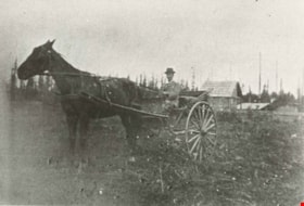
![Pat Byrne's Threshing Machine, [1892] (date of original) copied 1980 thumbnail](/media/hpo/_Data/_Archives_Images/_Unrestricted/371/459-002.jpg?width=280)
Pat Byrne's Threshing Machine
https://search.heritageburnaby.ca/link/archivedescription38542
- Repository
- City of Burnaby Archives
- Date
- [1892] (date of original) copied 1980
- Collection/Fonds
- Burnaby Historical Society fonds
- Description Level
- Item
- Physical Description
- 1 photograph : b&w ; 8.2 x 14.2 cm
- Scope and Content
- Photograph of five men standing on a flat-bottom vessel on the Fraser River. A label accompanying the photograph reads: "1st threshing outfit in Burnaby, about 1892. Owned by Pat Byrne, brother of Peter. Sold to Peter when Pat returned to Ireland to live. On Fraser River. L. to R.: Pat Byrne, C…
- Repository
- City of Burnaby Archives
- Date
- [1892] (date of original) copied 1980
- Collection/Fonds
- Burnaby Historical Society fonds
- Subseries
- New Westminster Public Library subseries
- Physical Description
- 1 photograph : b&w ; 8.2 x 14.2 cm
- Description Level
- Item
- Record No.
- 459-002
- Access Restriction
- No restrictions
- Reproduction Restriction
- No known restrictions
- Accession Number
- BHS2003-19
- Scope and Content
- Photograph of five men standing on a flat-bottom vessel on the Fraser River. A label accompanying the photograph reads: "1st threshing outfit in Burnaby, about 1892. Owned by Pat Byrne, brother of Peter. Sold to Peter when Pat returned to Ireland to live. On Fraser River. L. to R.: Pat Byrne, Capt. Stewart of "Alice", Peter Byrne and another (unknown)." Peter Byrne was a member of Burnaby's municipal council from 1894-1895, 1898-1906 and served as Reeve from 1906-1910. The threshing machine (visible behind the side paddle of the scow) was loaded onto this scow for transport from New Westminster to the Byrne farm in Burnaby.
- Subjects
- Agricultural Tools and Equipment
- Transportation - Boats
- Officials - Mayors and Reeves
- Geographic Features - Rivers
- Names
- Byrne, Pat
- Byrne, Peter
- Media Type
- Photograph
- Notes
- Title based on caption
Images
![Pat Byrne's Threshing Machine, [1892] (date of original) copied 1980 thumbnail](/media/hpo/_Data/_Archives_Images/_Unrestricted/371/459-002.jpg)
![Powerhouse, [189-?] (date of original), copied [196-?] thumbnail](/media/hpo/_Data/_BVM_Images/1976/1976_0145_0002_001.jpg?width=280)
Powerhouse
https://search.heritageburnaby.ca/link/museumdescription831
- Repository
- Burnaby Village Museum
- Date
- [189-?] (date of original), copied [196-?]
- Collection/Fonds
- Burnaby Village Museum Photograph collection
- Description Level
- Item
- Physical Description
- 1 photograph : b&w ; 7.6 x 9.6 cm print
- Scope and Content
- Photograph of a powerhouse with tall smoke stacks, located beside railway tracks. Three trams can be seen on the right side of the photograph and men are standing outside of the building. According to an accompanying note, the powerhouse doubled as a steam plant and a car barn. Constructed in 1891,…
- Repository
- Burnaby Village Museum
- Collection/Fonds
- Burnaby Village Museum Photograph collection
- Description Level
- Item
- Physical Description
- 1 photograph : b&w ; 7.6 x 9.6 cm print
- Scope and Content
- Photograph of a powerhouse with tall smoke stacks, located beside railway tracks. Three trams can be seen on the right side of the photograph and men are standing outside of the building. According to an accompanying note, the powerhouse doubled as a steam plant and a car barn. Constructed in 1891, it was between Edmonds and Highland Park on the Central Park Interurban Line. The steam plant provided power to run the line, then operated by Westminster and Vancouver Tramway Company.
- Subjects
- Transportation - Electric Railroads
- Accession Code
- HV976.145.2
- Access Restriction
- No restrictions
- Reproduction Restriction
- May be restricted by third party rights
- Date
- [189-?] (date of original), copied [196-?]
- Media Type
- Photograph
- Historic Neighbourhood
- Edmonds (Historic Neighbourhood)
- Planning Study Area
- Stride Avenue Area
- Scan Resolution
- 600
- Scan Date
- 2023-06-27
- Notes
- Title based on contents of photograph
Images
![Powerhouse, [189-?] (date of original), copied [196-?] thumbnail](/media/hpo/_Data/_BVM_Images/1976/1976_0145_0002_001.jpg)
![Team of horses at logging site, [1890] thumbnail](/media/hpo/_Data/_BVM_Images/1977/197701400001.jpg?width=280)
Team of horses at logging site
https://search.heritageburnaby.ca/link/museumdescription636
- Repository
- Burnaby Village Museum
- Date
- [1890]
- Collection/Fonds
- Burnaby Village Museum Photograph collection
- Description Level
- Item
- Physical Description
- 1 photograph : sepia ; 27 x 36 cm, mounted on card 27 x 36 cm
- Scope and Content
- Photograph of a team of ten equine animals reined together in pairs at a logging site at Gilley Avenue. The pair in front looks to be a mule and a draft horse while all other pairs appear to be draft horses.
- Repository
- Burnaby Village Museum
- Collection/Fonds
- Burnaby Village Museum Photograph collection
- Description Level
- Item
- Physical Description
- 1 photograph : sepia ; 27 x 36 cm, mounted on card 27 x 36 cm
- Scope and Content
- Photograph of a team of ten equine animals reined together in pairs at a logging site at Gilley Avenue. The pair in front looks to be a mule and a draft horse while all other pairs appear to be draft horses.
- Geographic Access
- Gilley Avenue
- Accession Code
- HV977.140.1
- Access Restriction
- No restrictions
- Date
- [1890]
- Media Type
- Photograph
- Historic Neighbourhood
- Fraser Arm (Historic Neighbourhood)
- Scan Resolution
- 600
- Scan Date
- 1/8/2010
- Scale
- 100
- Notes
- Title based on contents of photograph
Images
![Team of horses at logging site, [1890] thumbnail](/media/hpo/_Data/_BVM_Images/1977/197701400001.jpg)
![William Brenchley farm, [between 1890 and 1895] (date of original), copied 1985 thumbnail](/media/hpo/_Data/_Archives_Images/_Unrestricted/126/146-002.jpg?width=280)
William Brenchley farm
https://search.heritageburnaby.ca/link/archivedescription34864
- Repository
- City of Burnaby Archives
- Date
- [between 1890 and 1895] (date of original), copied 1985
- Collection/Fonds
- Burnaby Historical Society fonds
- Description Level
- Item
- Physical Description
- 1 photograph : b&w ; 8.8 x 12.5 cm print
- Scope and Content
- Photograph of a farm hand and horse team inside a large stump, taken on William Brenchley's farm. The farm was located at the northeast corner of Kingsway and 10th Avenue.
- Repository
- City of Burnaby Archives
- Date
- [between 1890 and 1895] (date of original), copied 1985
- Collection/Fonds
- Burnaby Historical Society fonds
- Subseries
- W.E. Brenchley subseries
- Physical Description
- 1 photograph : b&w ; 8.8 x 12.5 cm print
- Description Level
- Item
- Record No.
- 146-002
- Access Restriction
- No restrictions
- Reproduction Restriction
- No known restrictions
- Accession Number
- BHS1985-16
- Scope and Content
- Photograph of a farm hand and horse team inside a large stump, taken on William Brenchley's farm. The farm was located at the northeast corner of Kingsway and 10th Avenue.
- Media Type
- Photograph
- Photographer
- Thompson, S.J.
- Notes
- Title based on contents of photograph
- Geographic Access
- 10th Avenue
- Kingsway
- Historic Neighbourhood
- Edmonds (Historic Neighbourhood)
- Planning Study Area
- Edmonds Area
Images
![William Brenchley farm, [between 1890 and 1895] (date of original), copied 1985 thumbnail](/media/hpo/_Data/_Archives_Images/_Unrestricted/126/146-002.jpg)
![A.C. Hill, [189-] (date of original), copied 1977 thumbnail](/media/hpo/_Data/_BVM_Images/1977/1977_0123_0041_001.jpg?width=280)
A.C. Hill
https://search.heritageburnaby.ca/link/museumdescription1658
- Repository
- Burnaby Village Museum
- Date
- [189-] (date of original), copied 1977
- Collection/Fonds
- Burnaby Village Museum Photograph collection
- Description Level
- Item
- Physical Description
- 1 photograph : b&w ; 25.2 x 20.2 cm print
- Scope and Content
- Photograph of a one year old, dressed in a sailor shirt and pleated skirt, with boots, taken in a photographic studio. The inscription on the original photograph suggests the child is A.C. Hill, or Claude Hill, the son of Bernard Hill.
- Repository
- Burnaby Village Museum
- Collection/Fonds
- Burnaby Village Museum Photograph collection
- Description Level
- Item
- Physical Description
- 1 photograph : b&w ; 25.2 x 20.2 cm print
- Scope and Content
- Photograph of a one year old, dressed in a sailor shirt and pleated skirt, with boots, taken in a photographic studio. The inscription on the original photograph suggests the child is A.C. Hill, or Claude Hill, the son of Bernard Hill.
- Subjects
- Persons - Children
- Names
- Hill, Arthur Claude
- Accession Code
- HV977.123.41
- Access Restriction
- No restrictions
- Reproduction Restriction
- No known restrictions
- Date
- [189-] (date of original), copied 1977
- Media Type
- Photograph
- Scan Resolution
- 600
- Scan Date
- 2023-07-25
- Photographer
- Atkinson, J.
- Notes
- Annotation on recto of the orginal photograph reads: "A.C. Hill," and printed on the card mount of the original is: "J. Atkinson" and "Jane St. / Workington."
Images
![A.C. Hill, [189-] (date of original), copied 1977 thumbnail](/media/hpo/_Data/_BVM_Images/1977/1977_0123_0041_001.jpg)
![Baby, [189-] thumbnail](/media/hpo/_Data/_BVM_Images/1983/1983_0042_0124_001.jpg?width=280)
Baby
https://search.heritageburnaby.ca/link/museumdescription384
- Repository
- Burnaby Village Museum
- Date
- [189-]
- Collection/Fonds
- Burnaby Village Museum Photograph collection
- Description Level
- Item
- Physical Description
- 1 photograph : b&w ; 6.35 x 10.16 cm
- Scope and Content
- Photograph of a baby wearing a lace trimmed dress. The baby is sitting on a sofa with cushions at her back. A person's hand is visible, holding up the baby. The inscription on the cardmount of the photograph identifies the baby as Berla or Bertha E. Beallie (sp?) at age 9 months. She was 23.5 lbs.
- Repository
- Burnaby Village Museum
- Collection/Fonds
- Burnaby Village Museum Photograph collection
- Description Level
- Item
- Physical Description
- 1 photograph : b&w ; 6.35 x 10.16 cm
- Material Details
- printed on the card mount, recto, l.l. "HART'S,", l.r. "WATERTOWN, N. Y."
- inscribed in pencil on the card mount, verso, t. "Berla [or Bertha] E. Beallie [sp?]/ 9months/ 23 1/2 lbs"
- The photograph is mounted on a card supplied by the photo studio. The edges of the card are coloured gold
- Scope and Content
- Photograph of a baby wearing a lace trimmed dress. The baby is sitting on a sofa with cushions at her back. A person's hand is visible, holding up the baby. The inscription on the cardmount of the photograph identifies the baby as Berla or Bertha E. Beallie (sp?) at age 9 months. She was 23.5 lbs.
- Subjects
- Persons - Children
- Names
- Beallie, Bertha
- Accession Code
- HV983.42.124
- Reproduction Restriction
- No known restrictions
- Date
- [189-]
- Media Type
- Photograph
- Scan Resolution
- 600
- Scan Date
- 2023-11-21
- Scale
- 100
- Photographer
- Hart's Studio
- Notes
- Title based on contents of photograph
Images
![Baby, [189-] thumbnail](/media/hpo/_Data/_BVM_Images/1983/1983_0042_0124_001.jpg)
![Blanche Wilkinson, [between 1896 and 1900] thumbnail](/media/hpo/_Data/_Archives_Images/_Unrestricted/550/550-024.jpg?width=280)
Blanche Wilkinson
https://search.heritageburnaby.ca/link/archivedescription82374
- Repository
- City of Burnaby Archives
- Date
- [between 1896 and 1900]
- Collection/Fonds
- Hill family and Vidal family fonds
- Description Level
- Item
- Physical Description
- 1 photograph : sepia ; 10 x 6.5 cm
- Scope and Content
- Photograph is a portrait of Blanche Wilkinson.
- Repository
- City of Burnaby Archives
- Date
- [between 1896 and 1900]
- Collection/Fonds
- Hill family and Vidal family fonds
- Physical Description
- 1 photograph : sepia ; 10 x 6.5 cm
- Description Level
- Item
- Record No.
- 550-024
- Access Restriction
- No restrictions
- Reproduction Restriction
- No known restrictions
- Accession Number
- 2013-03
- Scope and Content
- Photograph is a portrait of Blanche Wilkinson.
- Subjects
- Persons - Children
- Names
- Wilkinson, Blanche
- Media Type
- Photograph
- Notes
- Title based on caption accompanying photograph
- Note in pencil on album page reads: "Blanche Wilkinson / 1890's"
- Note in pencil on verso reads: "Blanche Wilkinson / b. late 1890's"
- Photograph stamp on verso reads: "John Barron, / Photographer, / Sarnia."
Images
![Blanche Wilkinson, [between 1896 and 1900] thumbnail](/media/hpo/_Data/_Archives_Images/_Unrestricted/550/550-024.jpg)