More like 'Sussex Villa with sign'
Narrow Results By
Subject
- Accidents - Automobile Accidents 1
- Adornment 9
- Adornment - Lapel Pins 10
- Advertising Medium 104
- Advertising Medium - Business Cards 17
- Advertising Medium - Flyer 38
- Advertising Medium - Poster 18
- Advertising Medium - Signs and Signboards
- Aerial Photographs 27
- Agricultural Tools and Equipment - Plows 3
- Agriculture 4
- Agriculture - Crops 2
Person / Organization
- A & Aero Trading Salvage 1
- Admiral Hotel 2
- A. MacKenzie and Company Jubilee Store 3
- Anthony, Bill 1
- Astor Hotel 3
- Battersby, Frank 1
- BC Society of Model Engineers (BCSME) 1
- Bennett, Eric Warrington Howard 1
- Blue Mountain Flower and Garden Shop 1
- Bonsor Recreation Complex 1
- Bowker, A.D. 1
- British Columbia Auto Company 1

Arrow Neon Sign
https://search.heritageburnaby.ca/link/landmark861
- Repository
- Burnaby Heritage Planning
- Description
- Commercial building.
- Associated Dates
- 1961
- Other Names
- Lost in the 50's Drive-in
- Street View URL
- Google Maps Street View
- Repository
- Burnaby Heritage Planning
- Other Names
- Lost in the 50's Drive-in
- Geographic Access
- Edmonds Street
- Associated Dates
- 1961
- Description
- Commercial building.
- Heritage Value
- The Arrow Neon Sign was built in 1961 by the Neonette Sign Company of New Westminster when this property was opened as the Tomahawk Drive-in Restaurant. The restaurant was later known as Lindy's Burger and in 1990, the business was renamed Lost in the 50's Drive-in. It stands 20-foot tall and is composed of a large double-sided hollow steel panel serpentine arrow mounted on a pole supporting a lexan sign panel measuring approximately 8 feet wide by 4 feet tall. The sign was designed with three illuminated features: a round lamp at the top of the pole, a double-sided rectangular fluorescent sign panel box, and two double-sided rows of orange neon arrows that follow the large serpentine arrow. The Arrow Neon Sign remains as a rare surviving example of neon sign art in the city and is the only historic neon sign in South Burnaby. The sign has gained prominence over the years as it has been associated with this small iconic drive-in which has also been utilized as a set for film production. Additionally, the drive-in has played a prominent role in the Edmonds community as a popular setting for recent "Show and Shine" participants to park their classic cars.
- Locality
- Edmonds
- Historic Neighbourhood
- East Burnaby (Historic Neighbourhood)
- Planning Study Area
- Lakeview-Mayfield Area
- Builder
- Neonette Sign Company
- Community
- Burnaby
- Contributing Resource
- Structure
- Ownership
- Public (local)
- Street Address
- 7741 Edmonds Street
- Street View URL
- Google Maps Street View
Images


Helen 'The Swinging Girl' Neon Sign
https://search.heritageburnaby.ca/link/landmark591
- Repository
- Burnaby Heritage Planning
- Description
- Commercial building.
- Associated Dates
- 1956
- Formal Recognition
- Heritage Designation, Community Heritage Register
- Other Names
- Helen's Childrens Wear Sign
- Street View URL
- Google Maps Street View
- Repository
- Burnaby Heritage Planning
- Other Names
- Helen's Childrens Wear Sign
- Geographic Access
- Hastings Street
- Associated Dates
- 1956
- Formal Recognition
- Heritage Designation, Community Heritage Register
- Enactment Type
- Bylaw No. 12771
- Enactment Date
- 19/04/2010
- Description
- Commercial building.
- Heritage Value
- While the building here is of some importance as the former North Burnaby municipal office, its primary importance is its delightful neon sign that has become a North Burnaby landmark. Helen Arnold opened Helen’s Childrens Wear shop in the building next door to the old Municipal offices in 1948. In 1955, when North Burnaby moved out, she moved into the vacated building. As part of the renovations, Helen enlisted the assistance of her good friend Jimmy Wallace, owner of Vancouver’s Wallace Neon Company, to create a new sign for her expanded business. One of the company’s designers, Reeve Lehman, created the swinging neon girl that was installed in 1956. Designed in two parts, one section of the sign is cloud shaped and reads ‘Helen’s’ while the other section is a moving representation of a little girl on a swing. The sign is nine feet six inches high and nine feet wide, and the lower section is animated with an internal motor and gears. It immediately became a landmark on Hastings Street, and recently the sign’s design fame has spread far and wide as one of the best surviving examples of kinetic neon art in North America.
- Locality
- Vancouver Heights
- Historic Neighbourhood
- Vancouver Heights (Historic Neighbourhood)
- Planning Study Area
- Willingdon Heights Area
- Community
- Burnaby
- Names
- Helen's Childrens Wear
- Street Address
- 4142 Hastings Street
- Street View URL
- Google Maps Street View
Images


Martello Group sign at 6615 Telford Avenue
https://search.heritageburnaby.ca/link/archivedescription98675
- Repository
- City of Burnaby Archives
- Date
- 2022
- Collection/Fonds
- Disappearing Burnaby collection
- Description Level
- Item
- Physical Description
- 1 photograph (jpeg) : col.
- Scope and Content
- Photograph of a sign, which reads "Professionally Managed by Martello," on the lawn of an apartment building located at 6615 Telford Avenue. The building was constructed in 1964. Other residential towers, a construction crane, and cars parked along Telford Avenue are visible in the background.
- Repository
- City of Burnaby Archives
- Date
- 2022
- Collection/Fonds
- Disappearing Burnaby collection
- Physical Description
- 1 photograph (jpeg) : col.
- Description Level
- Item
- Record No.
- 634-022
- Access Restriction
- No restrictions
- Reproduction Restriction
- No restrictions
- Accession Number
- 2022-14
- Scope and Content
- Photograph of a sign, which reads "Professionally Managed by Martello," on the lawn of an apartment building located at 6615 Telford Avenue. The building was constructed in 1964. Other residential towers, a construction crane, and cars parked along Telford Avenue are visible in the background.
- Subjects
- Buildings - Residential
- Buildings - Residential - Apartments
- Advertising Medium - Signs and Signboards
- Media Type
- Photograph
- Photographer
- Cheung, Nakita
- Notes
- Title taken from the associated blog post
- Associated blog post: https://disappearingburnaby.wordpress.com/2022/06/09/martello-group/
- Geographic Access
- Telford Avenue
- Street Address
- 6615 Telford Avenue
- Historic Neighbourhood
- Central Park (Historic Neighbourhood)
- Planning Study Area
- Maywood Area
Images


Star Light Apartments sign
https://search.heritageburnaby.ca/link/archivedescription98677
- Repository
- City of Burnaby Archives
- Date
- 2022
- Collection/Fonds
- Disappearing Burnaby collection
- Description Level
- Item
- Physical Description
- 1 photograph (jpeg) : col.
- Scope and Content
- Photograph of the Blue Sky Investments Ltd.'s sign on the lawn of Star Light Apartments, a low-rise apartment building located at 6555 Telford Avenue. The building was constructed in 1964. The photograph depicts the scene at dusk; the building's entrance is visible to the left, with its exterior li…
- Repository
- City of Burnaby Archives
- Date
- 2022
- Collection/Fonds
- Disappearing Burnaby collection
- Physical Description
- 1 photograph (jpeg) : col.
- Description Level
- Item
- Record No.
- 634-024
- Access Restriction
- No restrictions
- Reproduction Restriction
- No restrictions
- Accession Number
- 2022-14
- Scope and Content
- Photograph of the Blue Sky Investments Ltd.'s sign on the lawn of Star Light Apartments, a low-rise apartment building located at 6555 Telford Avenue. The building was constructed in 1964. The photograph depicts the scene at dusk; the building's entrance is visible to the left, with its exterior lights on, and Telford Avenue and other neighbouring towers are visible in the background.
- Subjects
- Buildings - Residential
- Buildings - Residential - Apartments
- Advertising Medium - Signs and Signboards
- Media Type
- Photograph
- Photographer
- Cheung, Nakita
- Notes
- Title taken from the associated blog post
- Associated blog post: https://disappearingburnaby.wordpress.com/2022/06/24/star-light-apartments/
- Geographic Access
- Telford Avenue
- Street Address
- 6555 Telford Avenue
- Historic Neighbourhood
- Central Park (Historic Neighbourhood)
- Planning Study Area
- Marlborough Area
Images


Sussex Villa
https://search.heritageburnaby.ca/link/archivedescription98659
- Repository
- City of Burnaby Archives
- Date
- 2022
- Collection/Fonds
- Disappearing Burnaby collection
- Description Level
- Item
- Physical Description
- 1 photograph (jpeg) : col.
- Scope and Content
- Photograph of part of the exterior and front lawn of Sussex Villa, an apartment complex located at 6620-6630 Sussex Avenue, at night. The building was constructed in 1965 and is set to be developed into a high-rise tower by Keltic Canada Development. A light is on inside one of the apartment window…
- Repository
- City of Burnaby Archives
- Date
- 2022
- Collection/Fonds
- Disappearing Burnaby collection
- Physical Description
- 1 photograph (jpeg) : col.
- Description Level
- Item
- Record No.
- 634-006
- Access Restriction
- No restrictions
- Reproduction Restriction
- No restrictions
- Accession Number
- 2022-14
- Scope and Content
- Photograph of part of the exterior and front lawn of Sussex Villa, an apartment complex located at 6620-6630 Sussex Avenue, at night. The building was constructed in 1965 and is set to be developed into a high-rise tower by Keltic Canada Development. A light is on inside one of the apartment windows and a sign for the "Metrotown - Regional Town Centre Notification of Area Plan" stands on the lawn.
- Subjects
- Buildings - Residential - Apartments
- Buildings - Residential
- Advertising Medium - Signs and Signboards
- Planning - City Planning
- Media Type
- Photograph
- Photographer
- Cheung, Nakita
- Notes
- Title taken from the associated blog post
- Associated blog post: https://disappearingburnaby.wordpress.com/2022/01/29/sussex-villa-2/
- Geographic Access
- Sussex Avenue
- Street Address
- 6620 Sussex Avenue
- 6630 Sussex Avenue
- Historic Neighbourhood
- Central Park (Historic Neighbourhood)
- Planning Study Area
- Maywood Area
Images


Old Orchard Shopping Centre
https://search.heritageburnaby.ca/link/archivedescription93603
- Repository
- City of Burnaby Archives
- Date
- October 9, 1977
- Collection/Fonds
- Burnaby Public Library Contemporary Visual Archive Project
- Description Level
- Item
- Physical Description
- 1 photograph : b&w ; 12.5 x 17.5 cm
- Scope and Content
- Photograph of the Old Orchard Shopping Centre, located at Kingsway and Willingdon. The photograph is taken from across the road, facing northwest, and focuses on the shopping centre sign. The other stores' signs, including Shoppers Drug Mart and Autoplan, and a high-rise apartment building are visi…
- Repository
- City of Burnaby Archives
- Date
- October 9, 1977
- Collection/Fonds
- Burnaby Public Library Contemporary Visual Archive Project
- Physical Description
- 1 photograph : b&w ; 12.5 x 17.5 cm
- Description Level
- Item
- Record No.
- 556-560
- Access Restriction
- No restrictions
- Reproduction Restriction
- Reproduce for fair dealing purposes only
- Accession Number
- 2017-57
- Scope and Content
- Photograph of the Old Orchard Shopping Centre, located at Kingsway and Willingdon. The photograph is taken from across the road, facing northwest, and focuses on the shopping centre sign. The other stores' signs, including Shoppers Drug Mart and Autoplan, and a high-rise apartment building are visible in the background.
- Subjects
- Buildings - Commercial - Malls
- Advertising Medium - Signs and Signboards
- Buildings - Residential - Apartments
- Media Type
- Photograph
- Photographer
- Chapman, Fred
- Notes
- Title taken from project information form
- Accompanied by a project information form and 1 photograph (b&w negative ; 9.5 x 12.5 cm)
- BPL no. 4
- Geographic Access
- Kingsway
- Street Address
- 4469 Kingsway
- Historic Neighbourhood
- Central Park (Historic Neighbourhood)
- Planning Study Area
- Maywood Area
Images


Apartment at Albert and Ingleton
https://search.heritageburnaby.ca/link/archivedescription79031
- Repository
- City of Burnaby Archives
- Date
- September 12, 1976
- Collection/Fonds
- Burnaby Public Library Contemporary Visual Archive Project
- Description Level
- Item
- Physical Description
- 1 photograph : b&w ; 11 x 16 cm mounted on cardboard
- Scope and Content
- Photograph shows a sign on an apartment building on Albert Street near Ingleton Avenue.
- Repository
- City of Burnaby Archives
- Date
- September 12, 1976
- Collection/Fonds
- Burnaby Public Library Contemporary Visual Archive Project
- Physical Description
- 1 photograph : b&w ; 11 x 16 cm mounted on cardboard
- Description Level
- Item
- Record No.
- 556-102
- Access Restriction
- No restrictions
- Reproduction Restriction
- Reproduce for fair dealing purposes only
- Accession Number
- 2013-13
- Scope and Content
- Photograph shows a sign on an apartment building on Albert Street near Ingleton Avenue.
- Media Type
- Photograph
- Notes
- Scope note taken directly from BPL photograph description.
- 1 b&w copy negative : 10 x 12.5 cm accompanying
- Photographers identified by surnames only: Carr and Vardeman
- Geographic Access
- Albert Street
- Ingleton Avenue
- Historic Neighbourhood
- Vancouver Heights (Historic Neighbourhood)
- Planning Study Area
- Burnaby Heights Area
Images

![Condominiums, [2000] thumbnail](/media/hpo/_Data/_Archives_Images/_Unrestricted/535/535-2869-1.jpg?width=280)
Condominiums
https://search.heritageburnaby.ca/link/archivedescription97530
- Repository
- City of Burnaby Archives
- Date
- [2000]
- Collection/Fonds
- Burnaby NewsLeader photograph collection
- Description Level
- File
- Physical Description
- 2 photographs (tiff) : col.
- Scope and Content
- File contains photographs of two condominium buildings. One building has a sign that reads: "Final Sell Out," and towers are visible behind the complex in the other photograph.
- Repository
- City of Burnaby Archives
- Date
- [2000]
- Collection/Fonds
- Burnaby NewsLeader photograph collection
- Physical Description
- 2 photographs (tiff) : col.
- Description Level
- File
- Record No.
- 535-2869
- Access Restriction
- No restrictions
- Reproduction Restriction
- No restrictions
- Accession Number
- 2018-12
- Scope and Content
- File contains photographs of two condominium buildings. One building has a sign that reads: "Final Sell Out," and towers are visible behind the complex in the other photograph.
- Subjects
- Buildings - Residential - Condominiums
- Buildings - Residential
- Advertising Medium - Signs and Signboards
- Media Type
- Photograph
- Notes
- Title based on contents of file
- Collected by editorial for use in an October 2000 issue of the Burnaby NewsLeader
Images
![Condominiums, [2000] thumbnail](/media/hpo/_Data/_Archives_Images/_Unrestricted/535/535-2869-1.jpg)

5486 Dominion Street
https://search.heritageburnaby.ca/link/archivedescription91871
- Repository
- City of Burnaby Archives
- Date
- 1971
- Collection/Fonds
- Small family fonds
- Description Level
- Item
- Physical Description
- 1 photograph : b&w ; 9 cm x 9 cm
- Scope and Content
- Photograph of the Small family's house at 5486 Dominion Street with a "For Sale" sign on the lawn. The house was put up for sale by Lauretta Small after she inherited the Roberts' house at 5538 Dominion Street in 1969. Lauretta, by then a widow, relocated back into the Roberts' house which was th…
- Repository
- City of Burnaby Archives
- Date
- 1971
- Collection/Fonds
- Small family fonds
- Physical Description
- 1 photograph : b&w ; 9 cm x 9 cm
- Description Level
- Item
- Record No.
- 620-052
- Access Restriction
- No restrictions
- Reproduction Restriction
- No reproduction permitted
- Accession Number
- 2017-01
- Scope and Content
- Photograph of the Small family's house at 5486 Dominion Street with a "For Sale" sign on the lawn. The house was put up for sale by Lauretta Small after she inherited the Roberts' house at 5538 Dominion Street in 1969. Lauretta, by then a widow, relocated back into the Roberts' house which was the house she grew up in as a child.
- Media Type
- Photograph
- Notes
- Transcribed title
- Title transcribed from donor's notes
- Note in blue ink on verso of photograph reads: "P.14"
- Note in blue ink on verso of photograph reads: "5486 Dominion St / Burnaby, B.C. / Fall '71"
- 5486 Dominion Street later subdivided into two lots: 5480 and 5488 Dominion Street
- Street Address
- 5486 Dominion Street
- Historic Neighbourhood
- Burnaby Lake (Historic Neighbourhood)
- Planning Study Area
- Ardingley-Sprott Area
Images


Lillian Mann's property
https://search.heritageburnaby.ca/link/archivedescription46242
- Repository
- City of Burnaby Archives
- Date
- March 1983
- Collection/Fonds
- Columbian Newspaper collection
- Description Level
- Item
- Physical Description
- 1 photograph : b&w ; 15.5 x 23.5 cm
- Scope and Content
- Photograph of Lillian Mann's property, with signs which read such things as; "Forced Sale", "Expropriation Sale!" and Demolition Sale!" posted up along the front yard, and nailed to the large Cedar tree.
- Repository
- City of Burnaby Archives
- Date
- March 1983
- Collection/Fonds
- Columbian Newspaper collection
- Physical Description
- 1 photograph : b&w ; 15.5 x 23.5 cm
- Description Level
- Item
- Record No.
- 480-1130
- Access Restriction
- No restrictions
- Reproduction Restriction
- No restrictions
- Accession Number
- 2003-02
- Scope and Content
- Photograph of Lillian Mann's property, with signs which read such things as; "Forced Sale", "Expropriation Sale!" and Demolition Sale!" posted up along the front yard, and nailed to the large Cedar tree.
- Media Type
- Photograph
- Photographer
- King, Basil
- Notes
- Title based on contents of photograph
- Newspaper clipping attached to verso of photograph reads: "READY TO MOVE ... Lillian Mann, the Burnaby homeowner who waged a lengthy but unsuccessful battle against expropriation of her Cameron Street home, is ready to move. But she hasn't lost her spark, as the terse messages on her front lawn indicate. The property is to become a parking lot for the Cameron Public Library."
- Geographic Access
- Cameron Street
- Historic Neighbourhood
- Burquitlam (Historic Neighbourhood)
- Planning Study Area
- Lyndhurst Area
Images

![Prospective buyers at Strathmore development, [2004] thumbnail](/media/hpo/_Data/_Archives_Images/_Unrestricted/535/535-2369.jpg?width=280)
Prospective buyers at Strathmore development
https://search.heritageburnaby.ca/link/archivedescription96811
- Repository
- City of Burnaby Archives
- Date
- [2004]
- Collection/Fonds
- Burnaby NewsLeader photograph collection
- Description Level
- Item
- Physical Description
- 1 photograph (tiff) : col.
- Scope and Content
- Photograph of prospective buyers outside the sales centre for the Strathmore, a new townhouse and apartment development on Cameron Street across from Lougheed Town Centre. A crowd is gathering on the lawn and on chairs, and a sign advertising the development is in the foreground.
- Repository
- City of Burnaby Archives
- Date
- [2004]
- Collection/Fonds
- Burnaby NewsLeader photograph collection
- Physical Description
- 1 photograph (tiff) : col.
- Description Level
- Item
- Record No.
- 535-2369
- Access Restriction
- No restrictions
- Reproduction Restriction
- No restrictions
- Accession Number
- 2018-12
- Scope and Content
- Photograph of prospective buyers outside the sales centre for the Strathmore, a new townhouse and apartment development on Cameron Street across from Lougheed Town Centre. A crowd is gathering on the lawn and on chairs, and a sign advertising the development is in the foreground.
- Media Type
- Photograph
- Photographer
- Bartel, Mario
- Notes
- Title based on caption
- Collected by editorial for use in an April 2004 issue of the Burnaby NewsLeader
- Caption from metadata: "Prospective home buyers wait for their turn to enter the sales centre at the Strathmore, a new townhouse and apartment development to be built on Cameron St., across from Lougheed Town Centre. Anxious buyers in the red hot real estate market started lining up on Wednesday to get first crack at the new units."
- Geographic Access
- Cameron Street
- Historic Neighbourhood
- Burquitlam (Historic Neighbourhood)
- Planning Study Area
- Cameron Area
Images
![Prospective buyers at Strathmore development, [2004] thumbnail](/media/hpo/_Data/_Archives_Images/_Unrestricted/535/535-2369.jpg)
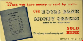
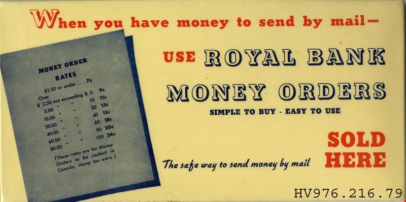
sign
https://search.heritageburnaby.ca/link/museumartifact23322
- Repository
- Burnaby Village Museum
- Accession Code
- HV976.216.79
- Description
- Money Orders - Sign. Advertising sign for a safe way to send money by mail through Royal Bank of Canada Money Orders. Rectangular sign that has yellowed, with red and blue text. The sign shows the rates for purchasing a money order. The back side is black with a string for hanging.
Images

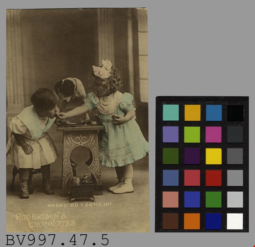
advertisement
https://search.heritageburnaby.ca/link/museumartifact38639
- Repository
- Burnaby Village Museum
- Accession Code
- BV997.47.5
- Description
- Robertson's Chocolates - Advertising Card. Advertising card for Robertson's Chocolates. Black and white photograph of two children at a small table sampling chocolates. There is a small dog standing on the table. There is a caption at the bottom of the photograph "Where Do I Come In?". The clothing of the children has been colour tinted with a light blue. On the back of the card is "Rotary Photo. England" and pencilled in is "$3.00 FC Mar 7391". The card measures 8.5cm x 13.5cm.
- Object History
- Donor purchased objects from various collectors and antique retailers between 1993 and 1997.
- Subjects
- Documentary Artifacts
- Documentary Artifacts - Labels
- Advertising Medium
- Advertising Medium - Signs and Signboards
Images

decal
https://search.heritageburnaby.ca/link/museumartifact23320
- Repository
- Burnaby Village Museum
- Accession Code
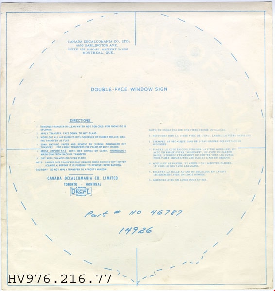
- HV976.216.77
- Description
- Royal Bank of Canada - Decal. A round double face window sign for The Royal Bank of Canada. The coat of arms is in the centre of the decal with a lion on one side and a unicorn on the other. "DIEU ET MON DROIT" on gold riband underneath the crest. There are directions of application on the back.
Images


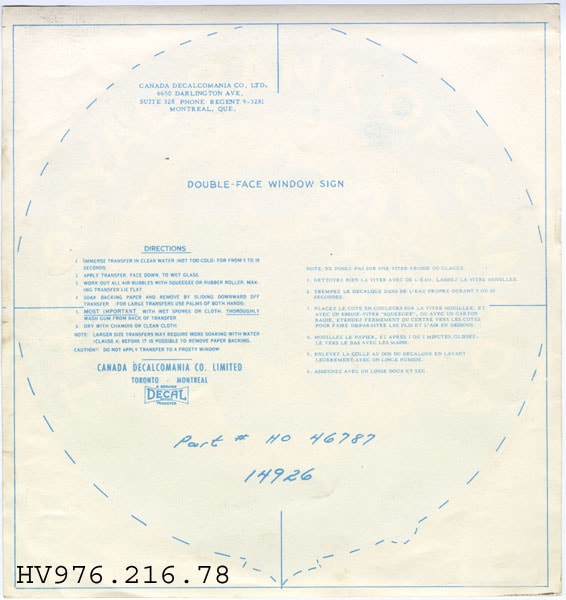
decal
https://search.heritageburnaby.ca/link/museumartifact23321
- Repository
- Burnaby Village Museum
- Accession Code
- HV976.216.78
- Description
- Royal Bank of Canada - Decal. A round double face window sign for The Royal Bank of Canada. The coat of arms is in the centre of the decal with a lion on one side and a unicorn on the other. "DIEU ET MON DROIT" on gold riband underneath the crest. There are directions of application on the back.
Images

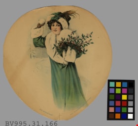
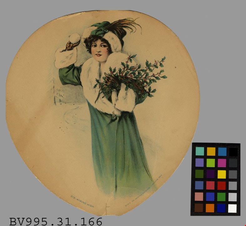
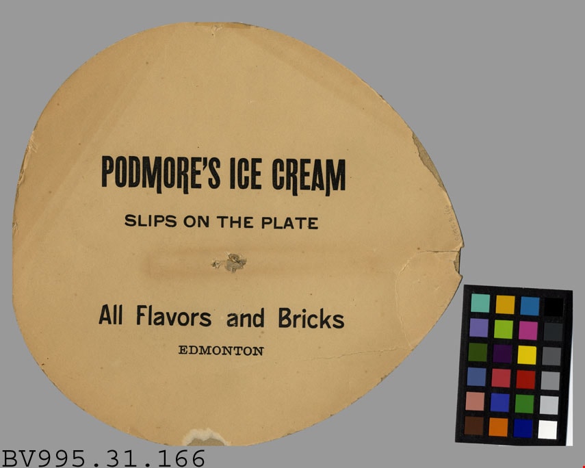
fan
https://search.heritageburnaby.ca/link/museumartifact38055
- Repository
- Burnaby Village Museum
- Accession Code
- BV995.31.166
- Description
- Podmore's Ice Cream - Advertisement -- [1912]. Advertising fan for Podmore's Ice Cream in Edmonton. One side of the fan states "Podmore's Ice Cream/ Slips On The Plate/ All Flavors and Bricks/ Edmonton". On the other side is an illustration of a woman in a green winter coat and hat holding a branch of holly in one hand and a snow ball in the other. The illustration is titled "212 - Aiming High" and was produced by The American Art Works in Coshocton, Ohio in 1912. The bottom of the fan has a spot where a handle would be attached. The fan measures 22cm x 23cm.
- Object History
- Donor purchased objects from various collectors and antique retailers.
- Colour
- Beige
Images
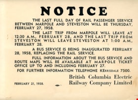
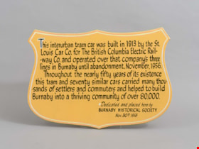
Notice
https://search.heritageburnaby.ca/link/museumartifact29081
- Repository
- Burnaby Village Museum
- Accession Code
- HV973.41.157
- Description
- A light weight 31.8 cm x 24 cm cardboard sign printed with "NOTICE" at the top. The BCER sign indicates the last day of service on February 28, 1958 between Marpole and Steveston using BCER interurbans which will be replaced with bus service. The sign is dated February 21, 1958.
- Country Made
- Canada
- Province Made
- British Columbia
- Publication Date
- 1958
- Subjects
- Advertising Medium
- Advertising Medium - Signs and Signboards
- Transportation
- Transportation - Electric Railroads
Images
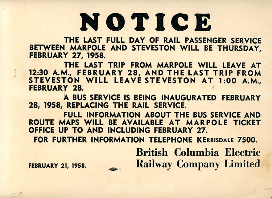
plaque
https://search.heritageburnaby.ca/link/museumartifact36450
- Repository
- Burnaby Village Museum
- Accession Code
- BV994.38.1
- Description
- Plaque. Badge shaped, made of ply-wooden, the background is painted yellow/tan and the lettering is black.
- Object History
- The plaque commemorates the history of the British Columbia Electric Railway in Burnaby, and the preservation of tram #1223 by the Burnaby Historical Society in 1958. Interurban tram No. 1223 has been restored by the joint efforts of the Friends of 1223 and Burnaby Village Museum. In March 2007 the tram was officially returned to Burnaby Village Museum and is currently on display, in a replica of a Tram Car Barn, at the Museum.
- Fraser Wilson hand lettered the sign.
- Marks/Labels
- "This Interurban Tram Car was built in 1913 by the St. Louis Car Co. for the British Columbia Electric Railway Co. and operated over that company's three lines in Burnaby until abandonment, November 1956. Throughout the nearly fifty years of its existence this tram and seventy similar cars carried many thousands of settlers and commuters and helped to build Burnaby into a thriving community of over 80,000"; "Dedicated and placed here by Burnaby Historical Society. Nov. 30th 1958", hand lettered.
- Subjects
- Transportation
- Transportation - Public Transit
- Transportation - Electric Railroads
- Advertising Medium
- Advertising Medium - Signs and Signboards
Images
plaque
https://search.heritageburnaby.ca/link/museumartifact40427
- Repository
- Burnaby Village Museum
- Accession Code
- BV985.5868.1
- Description
- Notice - Plaque. Wood backed plaque with cardboard notice from the British Columbia Electric Railway Company advising passengers to stand in a position that does not interfere with the Operator's vision while the vehicle was in motion. The notice also requests that the passengers refrain from unnecessary conversation with the Operator while the vehicle is in motion. The notice is attached to the wood with four tacks. The wood backing is 23.5cm x 18.5cm and the cardboard is 20cm x 15cm.
- Subjects
- Advertising Medium
- Advertising Medium - Signs and Signboards
- Transportation
- Transportation - Electric Railroads
- Transportation - Public Transit
Images
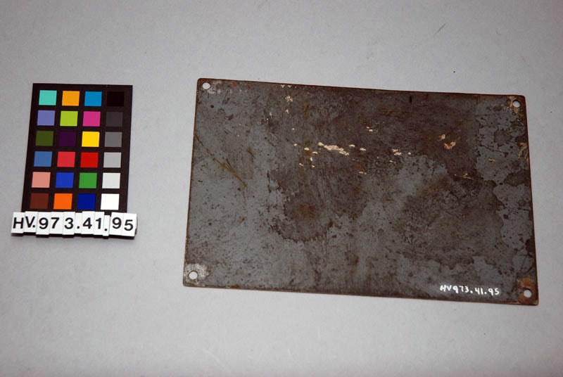
Sign
https://search.heritageburnaby.ca/link/museumartifact29019
- Repository
- Burnaby Village Museum
- Accession Code
- HV973.41.95
- Description
- Rectangular metallic, magnetic silver painted with "DONT PLAY WATER ON LIVE WIRES" painted in red. A blue sticker with "KS-K5" glued on the bottom. Four mounting holes in the corners. Length: 19.3 cm Width: 12.7 cm Thickness: 1 mm
- Object History
- key system S.F. California.
- Marks/Labels
- "DONT PLAY WATER" "ON" "LIVE WIRES"; Blue sticker "KS-KS";
- Subjects
- Transportation
- Transportation - Public Transit
- Transportation - Electric Railroads
- Advertising Medium
- Advertising Medium - Signs and Signboards
Images