More like 'Local construction'
Narrow Results By
Decade
- 2020s 5
- 2010s 8
- 2000s 106
- 1990s 78
- 1980s 82
- 1970s 158
- 1960s 45
- 1950s 84
- 1940s 193
- 1930s 97
- 1920s 157
- 1910s 165
- 1900s 62
- 1890s 13
- 1880s 7
- 1870s 2
- 1860s 2
- 1850s 1
- 1810s 1
- 1800s 1
- 1790s 1
- 1780s 1
- 1770s 1
- 1760s 1
- 1750s 1
- 1740s 1
- 1730s 1
- 1720s 1
- 1710s 1
- 1700s 1
- 1690s 1
- 1680s 1
- 1670s 1
- 1660s 1
- 1650s 1
- 1640s 1
- 1630s 1
- 1620s 1
- 1610s 1
- 1600s 1
- 1590s 1
- 1580s 1
- 1570s 1
- 1560s 1
- 1550s 1
- 1540s 1
- 1530s 1
- 1520s 1
- 1510s 1
- 1500s 1
- 1490s 1
- 1480s 1
Subject
- Accidents 3
- Advertising Medium 15
- Advertising Medium - Business Cards 8
- Advertising Medium - Flyer 2
- Advertising Medium - Signs and Signboards 12
- Aerial Photographs 6
- Agricultural Tools and Equipment 29
- Agricultural Tools and Equipment - Cultivators 3
- Agricultural Tools and Equipment - Gardening Equipment 13
- Agricultural Tools and Equipment - Plows 9
- Agricultural Tools and Equipment - Tractors 1
- Agriculture 2
Bill Speirs
https://search.heritageburnaby.ca/link/archivedescription35319
- Repository
- City of Burnaby Archives
- Date
- 1929 (date of original), copied 1986
- Collection/Fonds
- Burnaby Historical Society fonds
- Description Level
- Item
- Physical Description
- 1 photograph : b&w ; 12.7 x 17.8 cm print
- Scope and Content
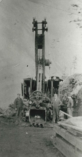
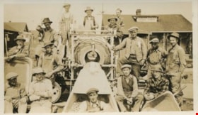
- Photograph of Bill Speirs operating a steam shovel. Bill and his wife, Dell Speirs, moved to Burnaby from Edmonton in 1929.
- Repository
- City of Burnaby Archives
- Date
- 1929 (date of original), copied 1986
- Collection/Fonds
- Burnaby Historical Society fonds
- Subseries
- Pioneer Tales subseries
- Physical Description
- 1 photograph : b&w ; 12.7 x 17.8 cm print
- Description Level
- Item
- Record No.
- 204-176
- Access Restriction
- No restrictions
- Reproduction Restriction
- No known restrictions
- Accession Number
- BHS1988-03
- Scope and Content
- Photograph of Bill Speirs operating a steam shovel. Bill and his wife, Dell Speirs, moved to Burnaby from Edmonton in 1929.
- Names
- Speirs, Bill
- Media Type
- Photograph
- Notes
- Title based on contents of photograph
Images
![Clearing Douglas Road, [190-?] (date of original), copied 1977 thumbnail](/media/hpo/_Data/_BVM_Images/1977/1977_0099_0002_001.jpg?width=280)
Clearing Douglas Road
https://search.heritageburnaby.ca/link/museumdescription560
- Repository
- Burnaby Village Museum
- Date
- [190-?] (date of original), copied 1977
- Collection/Fonds
- Burnaby Village Museum Photograph collection
- Description Level
- Item
- Physical Description
- 1 photograph : b&w ; 20.2 x 25.2 cm print
- Scope and Content
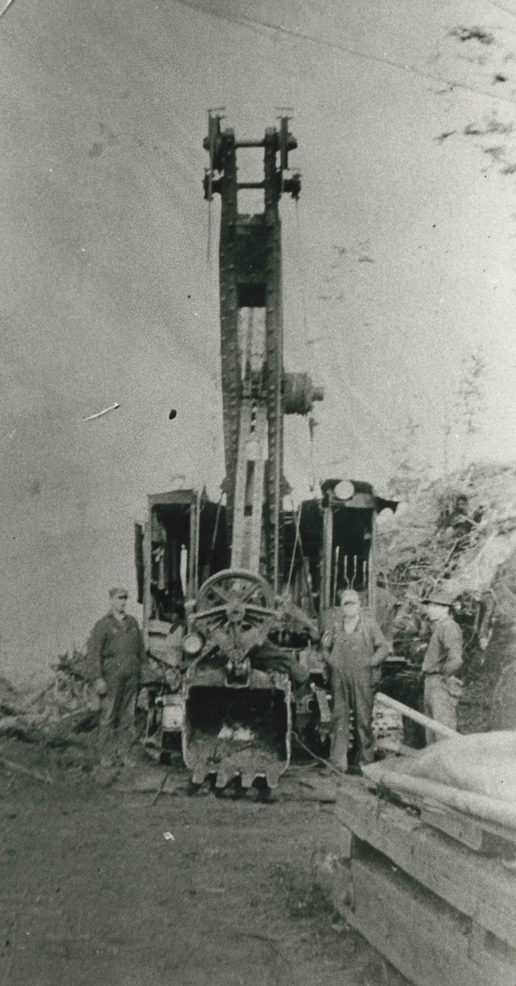
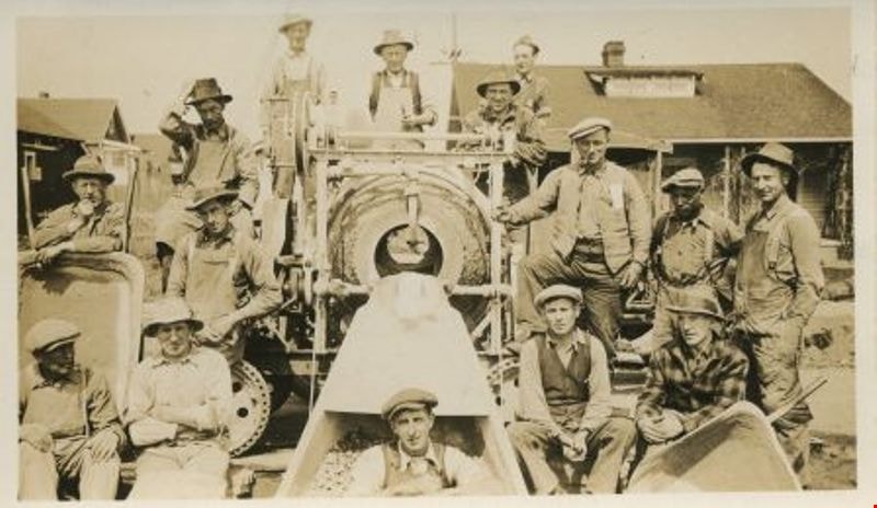
- Photograph of men in work clothes clearing Doulgas Road. A group of men to the right side of the photograph have shovels in their hands and are clearing rocks from the road. There is a small girl in a blouse and skirt standing beside two horses pulling a cart. Behind her is a group of men in wor…
- Repository
- Burnaby Village Museum
- Collection/Fonds
- Burnaby Village Museum Photograph collection
- Description Level
- Item
- Physical Description
- 1 photograph : b&w ; 20.2 x 25.2 cm print
- Scope and Content
- Photograph of men in work clothes clearing Doulgas Road. A group of men to the right side of the photograph have shovels in their hands and are clearing rocks from the road. There is a small girl in a blouse and skirt standing beside two horses pulling a cart. Behind her is a group of men in work clothes as well. There is fenced land to the right of the photograph, and electric power poles and trees line both sides of the road. The accession register and inscription on the photograph identify this as Douglas Road (later renamed in part Canada Way). An annotation on the back of the photo reads: "Working on Douglas Road on hill above Burnaby Lake. No Date."
- Geographic Access
- Douglas Road
- Canada Way
- Accession Code
- HV977.99.2
- Access Restriction
- No restrictions
- Reproduction Restriction
- May be restricted by third party rights
- Date
- [190-?] (date of original), copied 1977
- Media Type
- Photograph
- Historic Neighbourhood
- Burnaby Lake (Historic Neighbourhood)
- Scan Resolution
- 600
- Scan Date
- 2023-07-11
- Notes
- Title based on contents of photograph
Images
![Clearing Douglas Road, [190-?] (date of original), copied 1977 thumbnail](/media/hpo/_Data/_BVM_Images/1977/1977_0099_0002_001.jpg)
Glen Clark
https://search.heritageburnaby.ca/link/archivedescription78820
- Repository
- City of Burnaby Archives
- Date
- January 14, 1996
- Collection/Fonds
- Burnaby NewsLeader photograph collection
- Description Level
- Item
- Physical Description
- 1 photograph : b&w ; 15 x 24 cm
- Scope and Content
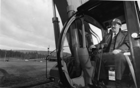
- Photograph of Investment minister and New Democratic Party (NDP) hopeful Glen Clark (later British Columbia Premier) in a bulldozer, breaking ground at the construction site of the High Occupancy Vehicle (HOV) lane on Highway 1 in Burnaby.
- Repository
- City of Burnaby Archives
- Date
- January 14, 1996
- Collection/Fonds
- Burnaby NewsLeader photograph collection
- Physical Description
- 1 photograph : b&w ; 15 x 24 cm
- Description Level
- Item
- Record No.
- 535-0137
- Access Restriction
- No restrictions
- Reproduction Restriction
- No reproduction permitted
- Accession Number
- 2012-11
- Scope and Content
- Photograph of Investment minister and New Democratic Party (NDP) hopeful Glen Clark (later British Columbia Premier) in a bulldozer, breaking ground at the construction site of the High Occupancy Vehicle (HOV) lane on Highway 1 in Burnaby.
- Subjects
- Construction - Road Construction
- Construction Tools and Equipment
- Officials - Elected Officials
- Officials - Premiers
- Names
- Clark, Glen
- Media Type
- Photograph
- Photographer
- Bartel, Mario
- Notes
- Title based on contents of photograph
- Note in blue ink on recto of photograph reads: "Bartel Bby 94A / 94% pg. 3 TriCity"
- Trim marks and/or reproduction instructions on recto (scan is cropped)
Images
![Grading at Oakalla, [1915] (date of original), copied 1991 thumbnail](/media/hpo/_Data/_Archives_Images/_Unrestricted/370/370-691.jpg?width=280)
Grading at Oakalla
https://search.heritageburnaby.ca/link/archivedescription38104
- Repository
- City of Burnaby Archives
- Date
- [1915] (date of original), copied 1991
- Collection/Fonds
- Burnaby Historical Society fonds
- Description Level
- Item
- Physical Description
- 1 photograph : b&w ; 2.9 x 5.2 cm print on contact sheet 20.7 x 26.7 cm
- Scope and Content
- Photograph of a crew of men working on a rail car line at Oakalla Prison Farm.
- Repository
- City of Burnaby Archives
- Date
- [1915] (date of original), copied 1991
- Collection/Fonds
- Burnaby Historical Society fonds
- Subseries
- Burnaby Image Bank subseries
- Physical Description
- 1 photograph : b&w ; 2.9 x 5.2 cm print on contact sheet 20.7 x 26.7 cm
- Description Level
- Item
- Record No.
- 370-691
- Access Restriction
- No restrictions
- Reproduction Restriction
- No known restrictions
- Accession Number
- BHS1999-03
- Scope and Content
- Photograph of a crew of men working on a rail car line at Oakalla Prison Farm.
- Subjects
- Construction Tools and Equipment
- Occupations - Railroad Labourers
- Construction - Railroad Construction
- Names
- Oakalla Prison Farm
- Media Type
- Photograph
- Notes
- Title based on caption of photograph
- 1 b&w copy negative accompanying
- Negative has a pink cast
- Caption at top of photograph reads, "Grading at Oakalla"
- Geographic Access
- Oakmount Crescent
- Street Address
- 5220 Oakmount Crescent
- Historic Neighbourhood
- Burnaby Lake (Historic Neighbourhood)
- Planning Study Area
- Oakalla Area
Images
![Grading at Oakalla, [1915] (date of original), copied 1991 thumbnail](/media/hpo/_Data/_Archives_Images/_Unrestricted/370/370-691.jpg)
The Sidewalk Crew
https://search.heritageburnaby.ca/link/archivedescription35150
- Repository
- City of Burnaby Archives
- Date
- 1927
- Collection/Fonds
- Burnaby Historical Society fonds
- Description Level
- Item
- Physical Description
- 1 photograph : sepia ; 6.4 x 11.4 cm
- Scope and Content
- Photograph of George Pearson's crew, including future Reeve Charles "Charlie" MacSorley, laying cement sidewalk in Burnaby. A note on back of the photograph indicates that the back left two are Jack Elliot and Charles MacSorley.
- Repository
- City of Burnaby Archives
- Date
- 1927
- Collection/Fonds
- Burnaby Historical Society fonds
- Subseries
- Pioneer Tales subseries
- Physical Description
- 1 photograph : sepia ; 6.4 x 11.4 cm
- Description Level
- Item
- Record No.
- 204-007
- Access Restriction
- No restrictions
- Reproduction Restriction
- No known restrictions
- Accession Number
- BHS1988-03
- Scope and Content
- Photograph of George Pearson's crew, including future Reeve Charles "Charlie" MacSorley, laying cement sidewalk in Burnaby. A note on back of the photograph indicates that the back left two are Jack Elliot and Charles MacSorley.
- Subjects
- Officials - Mayors and Reeves
- Construction Tools and Equipment
- Occupations - Labourers
- Construction - Road Construction
- Media Type
- Photograph
- Photographer
- Pearson, George
- Notes
- Title based on caption on back of photograph
Images
Along the Malahat
https://search.heritageburnaby.ca/link/archivedescription39349
- Repository
- City of Burnaby Archives
- Date
- 1922
- Collection/Fonds
- Peers Family and Hill Family fonds
- Description Level
- Item
- Physical Description
- 1 photograph : b&w ; 6 x 10.5 cm on page 24.5 x 32.5 cm (pasted in album)
- Scope and Content
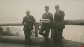
- Photograph of three men standing along the road, next to a wooden fence eating baked goods. Bob Peers is in the middle (holding the bakery box) and the man on the right is Francis Peers. The other man is unknown. A caption to the photograph reads: "The Malahat Summit '22."
- Repository
- City of Burnaby Archives
- Date
- 1922
- Collection/Fonds
- Peers Family and Hill Family fonds
- Physical Description
- 1 photograph : b&w ; 6 x 10.5 cm on page 24.5 x 32.5 cm (pasted in album)
- Description Level
- Item
- Record No.
- 477-668
- Access Restriction
- No restrictions
- Reproduction Restriction
- No known restrictions
- Accession Number
- 2007-12
- Scope and Content
- Photograph of three men standing along the road, next to a wooden fence eating baked goods. Bob Peers is in the middle (holding the bakery box) and the man on the right is Francis Peers. The other man is unknown. A caption to the photograph reads: "The Malahat Summit '22."
- Subjects
- Structures - Fences
- Media Type
- Photograph
- Notes
- Title based on caption accompanying photograph
Images

![Boy in front of a wire fence, [1915] thumbnail](/media/hpo/_Data/_BVM_Images/1985/1985_5813_0001_001.jpg?width=280)
Boy in front of a wire fence
https://search.heritageburnaby.ca/link/museumdescription1438
- Repository
- Burnaby Village Museum
- Date
- [1915]
- Collection/Fonds
- Burnaby Village Museum Photograph collection
- Description Level
- Item
- Physical Description
- 1 photograph : sepia ; 11.5 x 7 cm
- Scope and Content
- Photograph of a boy standing in front of a wire fence. There is barbed wire along the top of the fence. The season appears to be winter, because the tree have no leaves and the boy is wearing a cap and a winter coat. Location is not identified.
- Repository
- Burnaby Village Museum
- Collection/Fonds
- Burnaby Village Museum Photograph collection
- Description Level
- Item
- Physical Description
- 1 photograph : sepia ; 11.5 x 7 cm
- Material Details
- inscribed in pencil, verso, c. "185"
- Scope and Content
- Photograph of a boy standing in front of a wire fence. There is barbed wire along the top of the fence. The season appears to be winter, because the tree have no leaves and the boy is wearing a cap and a winter coat. Location is not identified.
- Subjects
- Structures - Fences
- Persons - Children
- Accession Code
- BV985.5813.1
- Access Restriction
- No restrictions
- Reproduction Restriction
- No known restrictions
- Date
- [1915]
- Media Type
- Photograph
- Related Material
- The boy and the fence in the photograph resembles the boy depicted in front of wire fence gate in photograph BV985.5822.1
- Scan Resolution
- 600
- Scan Date
- 2024-02-27
- Notes
- Title based on contents of photograph
Images
![Boy in front of a wire fence, [1915] thumbnail](/media/hpo/_Data/_BVM_Images/1985/1985_5813_0001_001.jpg)
![Boy standing at the fence, [1920] (date of original), copied 1986 thumbnail](/media/hpo/_Data/_Archives_Images/_Unrestricted/126/162-010.jpg?width=280)
Boy standing at the fence
https://search.heritageburnaby.ca/link/archivedescription34941
- Repository
- City of Burnaby Archives
- Date
- [1920] (date of original), copied 1986
- Collection/Fonds
- Burnaby Historical Society fonds
- Description Level
- Item
- Physical Description
- 1 photograph : b&w ; 12.5 x 8.8 cm print
- Scope and Content
- Photograph of a boy standing at a white picket fence holding onto a wheelbarrow alongside Marine Drive. The Unident house can be seen in the background.
- Repository
- City of Burnaby Archives
- Date
- [1920] (date of original), copied 1986
- Collection/Fonds
- Burnaby Historical Society fonds
- Subseries
- Photographs subseries
- Physical Description
- 1 photograph : b&w ; 12.5 x 8.8 cm print
- Description Level
- Item
- Record No.
- 162-010
- Access Restriction
- No restrictions
- Reproduction Restriction
- No known restrictions
- Accession Number
- BHS1986-13
- Scope and Content
- Photograph of a boy standing at a white picket fence holding onto a wheelbarrow alongside Marine Drive. The Unident house can be seen in the background.
- Media Type
- Photograph
- Notes
- Title based on contents of photograph
- Geographic Access
- Marine Drive
- Historic Neighbourhood
- Fraser Arm (Historic Neighbourhood)
- Planning Study Area
- Big Bend Area
Images
![Boy standing at the fence, [1920] (date of original), copied 1986 thumbnail](/media/hpo/_Data/_Archives_Images/_Unrestricted/126/162-010.jpg)
![Ethel Thrussell, [1914] thumbnail](/media/hpo/_Data/_Archives_Images/_Unrestricted/251/275-008.jpg?width=280)
Ethel Thrussell
https://search.heritageburnaby.ca/link/archivedescription36476
- Repository
- City of Burnaby Archives
- Date
- [1914]
- Collection/Fonds
- Burnaby Historical Society fonds
- Description Level
- Item
- Physical Description
- 1 photograph : b&w ; 8.5 x 12.5 cm print
- Scope and Content
- Photograph of Ethel Thrussell, one of Frederick and Harriett Fenwick Thrussell's children, at the gate of the Thrussell family home.
- Repository
- City of Burnaby Archives
- Date
- [1914]
- Collection/Fonds
- Burnaby Historical Society fonds
- Subseries
- Thrussell family subseries
- Physical Description
- 1 photograph : b&w ; 8.5 x 12.5 cm print
- Description Level
- Item
- Record No.
- 275-008
- Access Restriction
- No restrictions
- Reproduction Restriction
- No known restrictions
- Accession Number
- BHS1992-05
- Scope and Content
- Photograph of Ethel Thrussell, one of Frederick and Harriett Fenwick Thrussell's children, at the gate of the Thrussell family home.
- Subjects
- Structures - Fences
- Names
- Thrussell, Ethel
- Media Type
- Photograph
- Notes
- Title based on contents of photograph
- Geographic Access
- Marine Drive
- Nelson Avenue
- Historic Neighbourhood
- Fraser Arm (Historic Neighbourhood)
- Planning Study Area
- Big Bend Area
Images
![Ethel Thrussell, [1914] thumbnail](/media/hpo/_Data/_Archives_Images/_Unrestricted/251/275-008.jpg)
Fence on Clayton property
https://search.heritageburnaby.ca/link/archivedescription38898
- Repository
- City of Burnaby Archives
- Date
- 1916
- Collection/Fonds
- Peers Family and Hill Family fonds
- Description Level
- Item
- Physical Description
- 1 photograph : b&w ; 5.5 x 10 cm on page 14 x 17.5 cm (pasted in album)
- Scope and Content
- Photograph of the fence around portion of the Clayton property on Buckingham Avenue in the Burnaby Lake area.
- Repository
- City of Burnaby Archives
- Date
- 1916
- Collection/Fonds
- Peers Family and Hill Family fonds
- Physical Description
- 1 photograph : b&w ; 5.5 x 10 cm on page 14 x 17.5 cm (pasted in album)
- Description Level
- Item
- Record No.
- 477-217
- Access Restriction
- No restrictions
- Reproduction Restriction
- No known restrictions
- Accession Number
- 2007-12
- Scope and Content
- Photograph of the fence around portion of the Clayton property on Buckingham Avenue in the Burnaby Lake area.
- Subjects
- Structures - Fences
- Media Type
- Photograph
- Notes
- Title based on contents of photograph
- Geographic Access
- Buckingham Avenue
- Historic Neighbourhood
- Burnaby Lake (Historic Neighbourhood)
- Planning Study Area
- Morley-Buckingham Area
Images

![Four generations, [between 1900 and 1909] (date of original), copied [1988] thumbnail](/media/hpo/_Data/_BVM_Images/2018/2018_0041_0200_001.jpg?width=280)
Four generations
https://search.heritageburnaby.ca/link/museumdescription9959
- Repository
- Burnaby Village Museum
- Date
- [between 1900 and 1909] (date of original), copied [1988]
- Collection/Fonds
- Burnaby Village Museum fonds
- Description Level
- Item
- Physical Description
- 1 photograph : col. slide ; 35 mm
- Scope and Content
- Photograph of (left to right) Annn (Annie) Elizabeth Whiting (nee Love), her mother, Mrs. Martha Love and her grandfather George Leonard and her daughter Edith Whiting.The group is gathered together outside in a yard with a fence of what might be the home of Jesse and Martha Love.
- Repository
- Burnaby Village Museum
- Collection/Fonds
- Burnaby Village Museum fonds
- Series
- Jesse Love farmhouse series
- Subseries
- Love family photographs subseries
- Description Level
- Item
- Physical Description
- 1 photograph : col. slide ; 35 mm
- Scope and Content
- Photograph of (left to right) Annn (Annie) Elizabeth Whiting (nee Love), her mother, Mrs. Martha Love and her grandfather George Leonard and her daughter Edith Whiting.The group is gathered together outside in a yard with a fence of what might be the home of Jesse and Martha Love.
- Subjects
- Structures - Fences
- Names
- Leonard, George
- Love Family
- Whiting, Annie Elizabeth Love
- Clayton, Edith Annie Whiting
- Stanley, Esther Love
- Love, Martha Leonard, 1858-1920
- Geographic Access
- Cumberland Street
- Street Address
- 7651 Cumberland Street
- Accession Code
- BV018.41.200
- Access Restriction
- No restrictions
- Reproduction Restriction
- May be restricted by third party rights
- Date
- [between 1900 and 1909] (date of original), copied [1988]
- Media Type
- Photograph
- Historic Neighbourhood
- East Burnaby (Historic Neighbourhood)
- Planning Study Area
- Cariboo-Armstrong Area
- Scan Resolution
- 2400
- Scan Date
- 4-Mar-2019
- Scale
- 100
- Notes
- Title based on contents of photograph
Images
![Four generations, [between 1900 and 1909] (date of original), copied [1988] thumbnail](/media/hpo/_Data/_BVM_Images/2018/2018_0041_0200_001.jpg)
![Girl in gateway, [between 1912 and 1925] thumbnail](/media/hpo/_Data/_BVM_Images/1984/1984_0051_0028_001.jpg?width=280)
Girl in gateway
https://search.heritageburnaby.ca/link/museumdescription256
- Repository
- Burnaby Village Museum
- Date
- [between 1912 and 1925]
- Collection/Fonds
- Burnaby Village Museum Photograph collection
- Description Level
- Item
- Physical Description
- 1 photograph : b&w ; 9.8 x 7.2 cm
- Scope and Content
- Photograph of a girl in a dress tied at the waist with a white collar at the neck. She is wearing boots and a straw hat, and is standing by the gateway in a log fence. There is a cobblestone path way on which she is standing, and there are woods in the distance in the background. According to the a…
- Repository
- Burnaby Village Museum
- Collection/Fonds
- Burnaby Village Museum Photograph collection
- Description Level
- Item
- Physical Description
- 1 photograph : b&w ; 9.8 x 7.2 cm
- Scope and Content
- Photograph of a girl in a dress tied at the waist with a white collar at the neck. She is wearing boots and a straw hat, and is standing by the gateway in a log fence. There is a cobblestone path way on which she is standing, and there are woods in the distance in the background. According to the accession register, the location is at Buena Vista, Burnaby, between 1912 and 1925.
- Subjects
- Structures - Fences
- Accession Code
- HV984.51.28
- Access Restriction
- No restrictions
- Reproduction Restriction
- No known restrictions
- Date
- [between 1912 and 1925]
- Media Type
- Photograph
- Historic Neighbourhood
- East Burnaby (Historic Neighbourhood)
- Planning Study Area
- Cariboo-Armstrong Area
- Scan Resolution
- 600
- Scan Date
- 2023-10-10
- Notes
- Title based on contents of photograph
Images
![Girl in gateway, [between 1912 and 1925] thumbnail](/media/hpo/_Data/_BVM_Images/1984/1984_0051_0028_001.jpg)
![Having a picnic, [1920] thumbnail](/media/hpo/_Data/_Archives_Images/_Unrestricted/477/477-568.jpg?width=280)
Having a picnic
https://search.heritageburnaby.ca/link/archivedescription39249
- Repository
- City of Burnaby Archives
- Date
- [1920]
- Collection/Fonds
- Peers Family and Hill Family fonds
- Description Level
- Item
- Physical Description
- 1 photograph : b&w ; 7.5 x 12.5 cm on page 24.5 x 32.5 cm (pasted in album)
- Scope and Content
- Photograph of people having a picnic on a lawn. They are seated on the ground in front of a large decorative garden fence. Bob Peers is sitting to the far right, the rest of the people are unidentified.
- Repository
- City of Burnaby Archives
- Date
- [1920]
- Collection/Fonds
- Peers Family and Hill Family fonds
- Physical Description
- 1 photograph : b&w ; 7.5 x 12.5 cm on page 24.5 x 32.5 cm (pasted in album)
- Description Level
- Item
- Record No.
- 477-568
- Access Restriction
- No restrictions
- Reproduction Restriction
- No known restrictions
- Accession Number
- 2007-12
- Scope and Content
- Photograph of people having a picnic on a lawn. They are seated on the ground in front of a large decorative garden fence. Bob Peers is sitting to the far right, the rest of the people are unidentified.
- Media Type
- Photograph
- Notes
- Title based on contents of photograph
Images
![Having a picnic, [1920] thumbnail](/media/hpo/_Data/_Archives_Images/_Unrestricted/477/477-568.jpg)
![House at Buena Vista, Burnaby, [between 1912 and 1925] thumbnail](/media/hpo/_Data/_BVM_Images/1984/1984_0051_0029_001.jpg?width=280)
House at Buena Vista, Burnaby
https://search.heritageburnaby.ca/link/museumdescription257
- Repository
- Burnaby Village Museum
- Date
- [between 1912 and 1925]
- Collection/Fonds
- Burnaby Village Museum Photograph collection
- Description Level
- Item
- Physical Description
- 1 photograph : b&w ; 7.0 x 9.0 cm
- Scope and Content
- Photograph of a house with a large porch and a log fence with a gateway in the centre. There is a cobblestone pathway leading to the porch. According to the accession register, the location of the house is at Buena Vista, Burnaby, between 1912 and 1925.
- Repository
- Burnaby Village Museum
- Collection/Fonds
- Burnaby Village Museum Photograph collection
- Description Level
- Item
- Physical Description
- 1 photograph : b&w ; 7.0 x 9.0 cm
- Scope and Content
- Photograph of a house with a large porch and a log fence with a gateway in the centre. There is a cobblestone pathway leading to the porch. According to the accession register, the location of the house is at Buena Vista, Burnaby, between 1912 and 1925.
- Accession Code
- HV984.51.29
- Access Restriction
- No restrictions
- Reproduction Restriction
- No known restrictions
- Date
- [between 1912 and 1925]
- Media Type
- Photograph
- Historic Neighbourhood
- East Burnaby (Historic Neighbourhood)
- Planning Study Area
- Cariboo-Armstrong Area
- Related Material
- To see another photograph of the house, see HV984.51.17 and .19
- Scan Resolution
- 600
- Scan Date
- 2023-10-10
- Notes
- Title based on contents of photograph
Images
![House at Buena Vista, Burnaby, [between 1912 and 1925] thumbnail](/media/hpo/_Data/_BVM_Images/1984/1984_0051_0029_001.jpg)
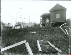
House with a broken wire fence
https://search.heritageburnaby.ca/link/museumdescription3079
- Repository
- Burnaby Village Museum
- Date
- [between 1900 and 1910
- Collection/Fonds
- Burnaby Village Museum Photograph collection
- Description Level
- Item
- Physical Description
- 1 photograph : b&w glass negative
- Scope and Content
- Photograph of an unidentified house with a broken wire fence in its front lawn. There are a couple of houses seen nearby the house and power poles running along a road behind the houses.
- Repository
- Burnaby Village Museum
- Collection/Fonds
- Burnaby Village Museum Photograph collection
- Description Level
- Item
- Physical Description
- 1 photograph : b&w glass negative
- Material Details
- inscribed in the negative, printed on the photograph, c. "no.2"
- Scope and Content
- Photograph of an unidentified house with a broken wire fence in its front lawn. There are a couple of houses seen nearby the house and power poles running along a road behind the houses.
- Accession Code
- HV973.110.10
- Access Restriction
- No restrictions
- Reproduction Restriction
- No known restrictions
- Date
- [between 1900 and 1910
- Media Type
- Photograph
- Scan Resolution
- 300
- Scan Date
- 16/8/2006
- Scale
- 100
- Notes
- Title based on contents of photograph
- 1 b&w contact print accompanying negative
Images

![Jesse Love farmhouse, [between 1900 and 1905] (date of original), copied 1998 thumbnail](/media/hpo/_Data/_BVM_Images/2000/200000450001.jpg?width=280)
Jesse Love farmhouse
https://search.heritageburnaby.ca/link/museumdescription1550
- Repository
- Burnaby Village Museum
- Date
- [between 1900 and 1905] (date of original), copied 1998
- Collection/Fonds
- Love family fonds
- Description Level
- Item
- Physical Description
- 1 photograph : b&w ; 18 x 25 cm print
- Scope and Content
- Photograph of two women standing by the wooden picket fence that surrounds the Jesse Love Farmhouse (very high pickets have been used for part of the fence).The Love farmhouse was located at 1390 Cumberland Road (after 1960- address was changed to 7651 Cumberland Street). The Love farmhouse was rel…
- Repository
- Burnaby Village Museum
- Collection/Fonds
- Love family fonds
- Description Level
- Item
- Physical Description
- 1 photograph : b&w ; 18 x 25 cm print
- Scope and Content
- Photograph of two women standing by the wooden picket fence that surrounds the Jesse Love Farmhouse (very high pickets have been used for part of the fence).The Love farmhouse was located at 1390 Cumberland Road (after 1960- address was changed to 7651 Cumberland Street). The Love farmhouse was relocated to the site of the Burnaby Village Museum in 1988 where it was restored to the 1920s era.
- Subjects
- Buildings - Heritage
- Structures - Fences
- Geographic Access
- Cumberland Street
- Street Address
- 7651 Cumberland Street
- Accession Code
- BV000.45.1
- Access Restriction
- No restrictions
- Date
- [between 1900 and 1905] (date of original), copied 1998
- Media Type
- Photograph
- Historic Neighbourhood
- East Burnaby (Historic Neighbourhood)
- Planning Study Area
- Cariboo-Armstrong Area
- Scan Resolution
- 600
- Scan Date
- 09-Jun-09
- Scale
- 100
- Notes
- Title based on contents of photograph
- Note in pencil on verso of photograph reads: "Jesse Love Farmhouse Burnaby BC"
- See also photograph: BV018.41.146
Images
![Jesse Love farmhouse, [between 1900 and 1905] (date of original), copied 1998 thumbnail](/media/hpo/_Data/_BVM_Images/2000/200000450001.jpg)
![Jesse Love farmhouse, [between 1900 and 1905] (date of original), copied [1988] thumbnail](/media/hpo/_Data/_BVM_Images/2018/2018_0041_0199_001.jpg?width=280)
Jesse Love farmhouse
https://search.heritageburnaby.ca/link/museumdescription9958
- Repository
- Burnaby Village Museum
- Date
- [between 1900 and 1905] (date of original), copied [1988]
- Collection/Fonds
- Burnaby Village Museum fonds
- Description Level
- Item
- Physical Description
- 1 photograph : col. slide ; 35 mm
- Scope and Content
- Photograph of two women standing by the wooden picket fence that surrounds the Jesse Love farmhouse (very high pickets have been used for part of the fence).The Love farmhouse was located at 1390 Cumberland Road (after 1960- address was changed to 7651 Cumberland Street). The Love farmhouse was rel…
- Repository
- Burnaby Village Museum
- Collection/Fonds
- Burnaby Village Museum fonds
- Series
- Jesse Love farmhouse series
- Subseries
- Love family photographs subseries
- Description Level
- Item
- Physical Description
- 1 photograph : col. slide ; 35 mm
- Scope and Content
- Photograph of two women standing by the wooden picket fence that surrounds the Jesse Love farmhouse (very high pickets have been used for part of the fence).The Love farmhouse was located at 1390 Cumberland Road (after 1960- address was changed to 7651 Cumberland Street). The Love farmhouse was relocated to the site of the Burnaby Village Museum in 1988 where it was restored to the 1920s era.
- Geographic Access
- Cumberland Street
- Street Address
- 7651 Cumberland Street
- Accession Code
- BV018.41.199
- Access Restriction
- No restrictions
- Reproduction Restriction
- May be restricted by third party rights
- Date
- [between 1900 and 1905] (date of original), copied [1988]
- Media Type
- Photograph
- Historic Neighbourhood
- East Burnaby (Historic Neighbourhood)
- Planning Study Area
- Cariboo-Armstrong Area
- Scan Resolution
- 2400
- Scan Date
- 4-Mar-2019
- Scale
- 100
- Notes
- Title based on content of photograph
Images
![Jesse Love farmhouse, [between 1900 and 1905] (date of original), copied [1988] thumbnail](/media/hpo/_Data/_BVM_Images/2018/2018_0041_0199_001.jpg)
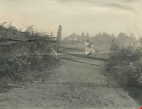
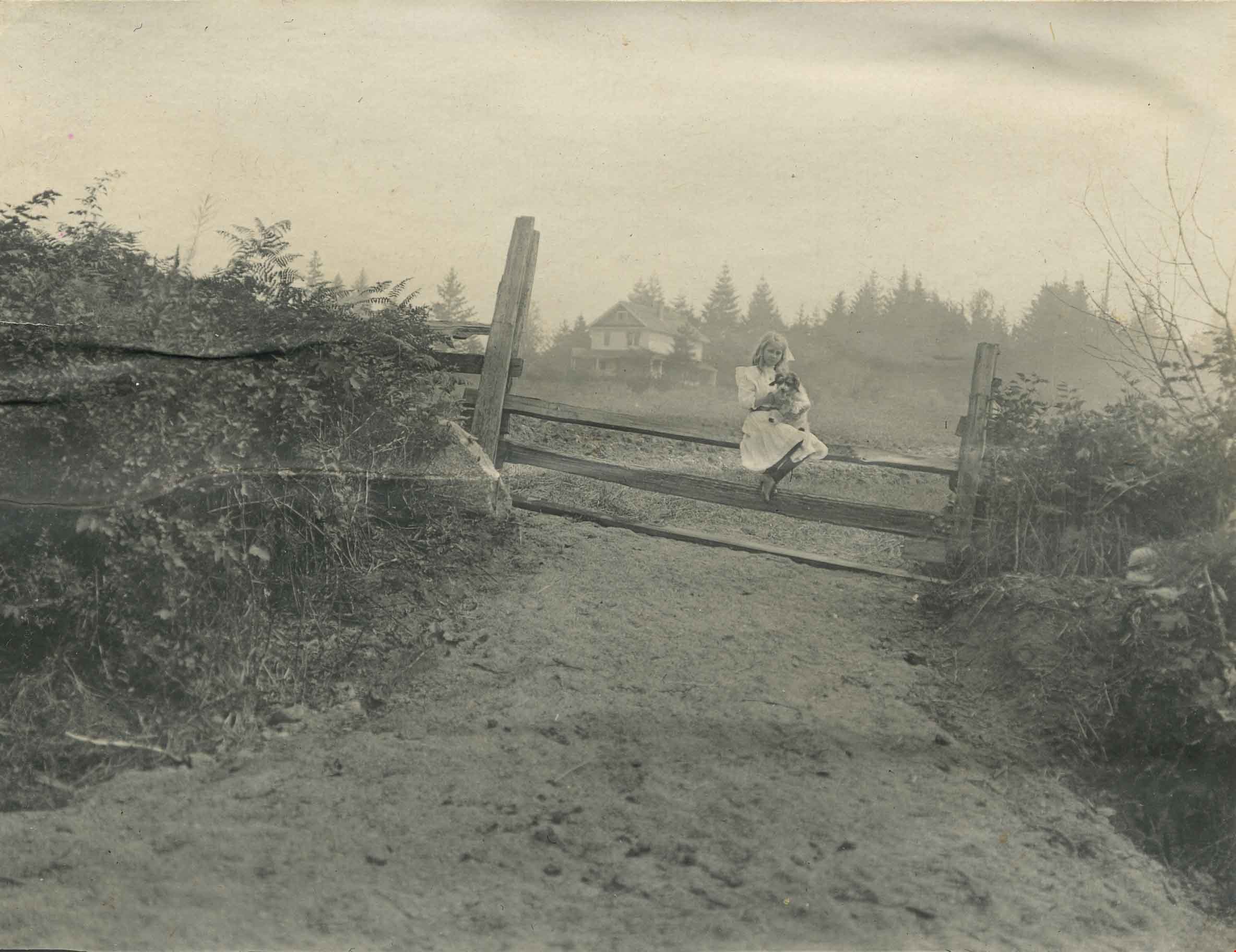
Kitty Hill sitting on a fence
https://search.heritageburnaby.ca/link/archivedescription39559
- Repository
- City of Burnaby Archives
- Date
- 1910
- Collection/Fonds
- Peers Family and Hill Family fonds
- Description Level
- Item
- Physical Description
- 1 photograph : b&w ; 7.8 x 10.1 cm on page 21.5 x 28 cm (pasted in album0
- Scope and Content
- Photograph of Kitty Hill sitting on a fence, holding a dog in her lap. The Hill family home, known as Broadview, is faintly visible in the background. It was located on Buckingham Avenue.
- Repository
- City of Burnaby Archives
- Date
- 1910
- Collection/Fonds
- Peers Family and Hill Family fonds
- Physical Description
- 1 photograph : b&w ; 7.8 x 10.1 cm on page 21.5 x 28 cm (pasted in album0
- Description Level
- Item
- Record No.
- 477-878
- Access Restriction
- No restrictions
- Reproduction Restriction
- No known restrictions
- Accession Number
- 2007-12
- Scope and Content
- Photograph of Kitty Hill sitting on a fence, holding a dog in her lap. The Hill family home, known as Broadview, is faintly visible in the background. It was located on Buckingham Avenue.
- Subjects
- Animals - Dogs
- Structures - Fences
- Media Type
- Photograph
- Notes
- Title based on contents of photograph
- Geographic Access
- Buckingham Avenue
- Street Address
- 5730 Buckingham Avenue
- Historic Neighbourhood
- Burnaby Lake (Historic Neighbourhood)
- Planning Study Area
- Morley-Buckingham Area
Images
![Lougheed Drive-In Theatre storm damage, [1962] (date of original), copied 1991 thumbnail](/media/hpo/_Data/_Archives_Images/_Unrestricted/370/370-471.jpg?width=280)
Lougheed Drive-In Theatre storm damage
https://search.heritageburnaby.ca/link/archivedescription37883
- Repository
- City of Burnaby Archives
- Date
- [1962] (date of original), copied 1991
- Collection/Fonds
- Burnaby Historical Society fonds
- Description Level
- Item
- Physical Description
- 1 photograph : b&w ; 3.0 x 2.9 cm print on contact sheet 20.1 x 26.7 cm
- Scope and Content
- Photograph of damage caused by Typhoon "Freda" on October 12, 1962 to the fence at the Lougheed Drive-In Theatre on the 4200 block of Lougheed Highway at Gilmore Avenue. This photograph was taken looking down Lougheed Highway.
- Repository
- City of Burnaby Archives
- Date
- [1962] (date of original), copied 1991
- Collection/Fonds
- Burnaby Historical Society fonds
- Subseries
- Burnaby Image Bank subseries
- Physical Description
- 1 photograph : b&w ; 3.0 x 2.9 cm print on contact sheet 20.1 x 26.7 cm
- Description Level
- Item
- Record No.
- 370-471
- Access Restriction
- No restrictions
- Reproduction Restriction
- No restrictions
- Accession Number
- BHS1999-03
- Scope and Content
- Photograph of damage caused by Typhoon "Freda" on October 12, 1962 to the fence at the Lougheed Drive-In Theatre on the 4200 block of Lougheed Highway at Gilmore Avenue. This photograph was taken looking down Lougheed Highway.
- Media Type
- Photograph
- Notes
- Title based on contents of photograph
- 1 b&w copy negative accompanying
- Negative has a pink cast
- Geographic Access
- Lougheed Highway
- Historic Neighbourhood
- Broadview (Historic Neighbourhood)
- Planning Study Area
- West Central Valley Area
Images
![Lougheed Drive-In Theatre storm damage, [1962] (date of original), copied 1991 thumbnail](/media/hpo/_Data/_Archives_Images/_Unrestricted/370/370-471.jpg)

Original gateposts of Sprott Lodge
https://search.heritageburnaby.ca/link/archivedescription38374
- Repository
- City of Burnaby Archives
- Date
- 1990
- Collection/Fonds
- Burnaby Historical Society fonds
- Description Level
- Item
- Physical Description
- 1 photograph : col. ; 8.8 x 13 cm
- Scope and Content
- Photograph of the original gateposts and the driveway leading into the site of Mayfield Lodge, which was owned by L.E.Sprott.
- Repository
- City of Burnaby Archives
- Date
- 1990
- Collection/Fonds
- Burnaby Historical Society fonds
- Subseries
- Municipal record subseries
- Physical Description
- 1 photograph : col. ; 8.8 x 13 cm
- Description Level
- Item
- Record No.
- 422-005
- Access Restriction
- No restrictions
- Reproduction Restriction
- Reproduce for fair dealing purposes only
- Accession Number
- BHS2001-09
- Scope and Content
- Photograph of the original gateposts and the driveway leading into the site of Mayfield Lodge, which was owned by L.E.Sprott.
- Subjects
- Buildings - Heritage
- Structures - Fences
- Media Type
- Photograph
- Photographer
- Wolf, Jim
- Notes
- Title based on contents of photograph.
- Geographic Access
- Canada Way
- Historic Neighbourhood
- Burnaby Lake (Historic Neighbourhood)
- Planning Study Area
- Morley-Buckingham Area
Images
