More like 'Caila Anderson with traffic signs'
Narrow Results By
Subject
- Advertising Medium 1
- Advertising Medium - Signs and Signboards 8
- Agricultural Tools and Equipment - Gardening Equipment 3
- Agriculture - Farms 2
- Animals - Deer 1
- Animals - Fowl 2
- Armament 1
- Buildings - Agricultural - Greenhouses 1
- Buildings - Civic - City Halls 9
- Buildings - Commercial 6
- Buildings - Commercial - Drugstores 1
- Buildings - Commercial - Grocery Stores 1
![Granville Street, Vancouver, [1910] thumbnail](/media/hpo/_Data/_BVM_Images/1972/1972_0050_0008_001.jpg?width=280)
Granville Street, Vancouver
https://search.heritageburnaby.ca/link/museumdescription1069
- Repository
- Burnaby Village Museum
- Date
- [1910]
- Collection/Fonds
- Burnaby Village Museum Photograph collection
- Description Level
- Item
- Physical Description
- 1 photograph : b&w ; 7.4 x 9.8 cm
- Scope and Content
- Photograph of Granville Street, looking north. Signs for "Fletchers Pianos" and the "Colonial Theatre" can be seen. The north shore is faintly visible across Burrard Inlet.
- Repository
- Burnaby Village Museum
- Collection/Fonds
- Burnaby Village Museum Photograph collection
- Description Level
- Item
- Physical Description
- 1 photograph : b&w ; 7.4 x 9.8 cm
- Scope and Content
- Photograph of Granville Street, looking north. Signs for "Fletchers Pianos" and the "Colonial Theatre" can be seen. The north shore is faintly visible across Burrard Inlet.
- Subjects
- Advertising Medium - Signs and Signboards
- Buildings - Commercial
- Geographic Features - Roads
- Geographic Access
- Vancouver
- Accession Code
- HV972.50.8
- Access Restriction
- No restrictions
- Reproduction Restriction
- No known restrictions
- Date
- [1910]
- Media Type
- Photograph
- Scan Resolution
- 600
- Scan Date
- 2023-04-04
- Photographer
- Dean, H.M.
- Notes
- Title based on contents of photograph
- An annotation on the back of the photograph reads, "Granville St. - 1910."
Images
![Granville Street, Vancouver, [1910] thumbnail](/media/hpo/_Data/_BVM_Images/1972/1972_0050_0008_001.jpg)
![Dow, Fraser and Company Limited, [1915] thumbnail](/media/hpo/_Data/_BVM_Images/1977/1977_0077_0001_001.jpg?width=280)
Dow, Fraser and Company Limited
https://search.heritageburnaby.ca/link/museumdescription551
- Repository
- Burnaby Village Museum
- Date
- [1915]
- Collection/Fonds
- Burnaby Village Museum Photograph collection
- Description Level
- Item
- Physical Description
- 1 photograph : sepia ; 16.5 x 21.5 cm photogravure
- Scope and Content
- Photograph of Mr. Eric Warrington Howard Bennett standing on the doorway to a store with large signs for a branch of Dow, Fraser & Co. Limited for real estate, loans, and fire insurance. The trust company is advertised on the sign as having been established in 1900. There is another store in the bu…
- Repository
- Burnaby Village Museum
- Collection/Fonds
- Burnaby Village Museum Photograph collection
- Description Level
- Item
- Physical Description
- 1 photograph : sepia ; 16.5 x 21.5 cm photogravure
- Scope and Content
- Photograph of Mr. Eric Warrington Howard Bennett standing on the doorway to a store with large signs for a branch of Dow, Fraser & Co. Limited for real estate, loans, and fire insurance. The trust company is advertised on the sign as having been established in 1900. There is another store in the building that is unidentified. Eric Warrington Howard Bennett was the branch manager of the Dow, Fraser company which started in Burnaby circa 1915. The store was located on the corner of McKay Avenue and the BC Electric Railway tracks. Later, a top storey was added to the building. An annotation on the back of the photograph reads: "Burnaby Branch Office. / E.W.H. Bennett / Manager."
- Geographic Access
- McKay Avenue
- Accession Code
- HV977.77.1
- Access Restriction
- No restrictions
- Reproduction Restriction
- No known restrictions
- Date
- [1915]
- Media Type
- Photograph
- Historic Neighbourhood
- Central Park (Historic Neighbourhood)
- Planning Study Area
- Maywood Area
- Scan Resolution
- 600
- Scan Date
- 2023-07-11
- Notes
- Title based on contents of photograph
Images
![Dow, Fraser and Company Limited, [1915] thumbnail](/media/hpo/_Data/_BVM_Images/1977/1977_0077_0001_001.jpg)
![Gordon Presbyterian Church Refreshment Building, [1918] (date of original), copied 1987 thumbnail](/media/hpo/_Data/_Archives_Images/_Unrestricted/126/193-003.jpg?width=280)
Gordon Presbyterian Church Refreshment Building
https://search.heritageburnaby.ca/link/archivedescription35102
- Repository
- City of Burnaby Archives
- Date
- [1918] (date of original), copied 1987
- Collection/Fonds
- Burnaby Historical Society fonds
- Description Level
- Item
- Physical Description
- 1 photograph : b&w ; 8.8 x 12.5 cm print
- Scope and Content
- Photograph of the exterior of the Gordon Presbyterian Church refreshment building at the Central Park Agricultural Exhibition. Signs on the building read, "Gordon Presby Church," "Continuous Performance," "This is the Best," "Home Cooking / [illegible] just like Mother's / [Smells?] Good! Tastes B…
- Repository
- City of Burnaby Archives
- Date
- [1918] (date of original), copied 1987
- Collection/Fonds
- Burnaby Historical Society fonds
- Subseries
- Gordon Presbyterian Church subseries
- Physical Description
- 1 photograph : b&w ; 8.8 x 12.5 cm print
- Description Level
- Item
- Record No.
- 193-003
- Access Restriction
- No restrictions
- Reproduction Restriction
- No known restrictions
- Accession Number
- BHS1987-02
- Scope and Content
- Photograph of the exterior of the Gordon Presbyterian Church refreshment building at the Central Park Agricultural Exhibition. Signs on the building read, "Gordon Presby Church," "Continuous Performance," "This is the Best," "Home Cooking / [illegible] just like Mother's / [Smells?] Good! Tastes Better!," "Place to Dine," and "Hot Meals." Three women and a boy are outside the building.
- Subjects
- Exhibitions - Agricultural
- Buildings - Commercial - Restaurants
- Advertising Medium - Signs and Signboards
- Media Type
- Photograph
- Notes
- Title based on contents of photograph
- Geographic Access
- Central Park
- Imperial Street
- Street Address
- 3883 Imperial Street
- Historic Neighbourhood
- Central Park (Historic Neighbourhood)
- Planning Study Area
- Maywood Area
Images
![Gordon Presbyterian Church Refreshment Building, [1918] (date of original), copied 1987 thumbnail](/media/hpo/_Data/_Archives_Images/_Unrestricted/126/193-003.jpg)
![Gordon Presbyterian Church Refreshment Tent, [1912] (date of original), copied 1987 thumbnail](/media/hpo/_Data/_Archives_Images/_Unrestricted/126/193-001.jpg?width=280)
Gordon Presbyterian Church Refreshment Tent
https://search.heritageburnaby.ca/link/archivedescription35100
- Repository
- City of Burnaby Archives
- Date
- [1912] (date of original), copied 1987
- Collection/Fonds
- Burnaby Historical Society fonds
- Description Level
- Item
- Physical Description
- 1 photograph : b&w ; 8.8 x 12.5 cm print
- Scope and Content
- Photograph of the exterior of the Gordon Presbyterian Church refreshment tent at the Central Park Agricultural Exhibition. Banners above the door of the tent read, "Gordon Presby Church Refreshments" and "Hot Meals." Other banners and penants read, "God Save the King" and "Canada." Nine women an…
- Repository
- City of Burnaby Archives
- Date
- [1912] (date of original), copied 1987
- Collection/Fonds
- Burnaby Historical Society fonds
- Subseries
- Gordon Presbyterian Church subseries
- Physical Description
- 1 photograph : b&w ; 8.8 x 12.5 cm print
- Description Level
- Item
- Record No.
- 193-001
- Access Restriction
- No restrictions
- Reproduction Restriction
- No known restrictions
- Accession Number
- BHS1987-02
- Scope and Content
- Photograph of the exterior of the Gordon Presbyterian Church refreshment tent at the Central Park Agricultural Exhibition. Banners above the door of the tent read, "Gordon Presby Church Refreshments" and "Hot Meals." Other banners and penants read, "God Save the King" and "Canada." Nine women and two men are standing outside the tent. The women are wearing aprons. There is an automobile parked on the right side of the photograph.
- Subjects
- Buildings - Commercial - Restaurants
- Advertising Medium - Signs and Signboards
- Structures - Tents
- Media Type
- Photograph
- Notes
- Title based on contents of photograph
- Geographic Access
- Central Park
- Imperial Street
- Street Address
- 3883 Imperial Street
- Historic Neighbourhood
- Central Park (Historic Neighbourhood)
- Planning Study Area
- Maywood Area
Images
![Gordon Presbyterian Church Refreshment Tent, [1912] (date of original), copied 1987 thumbnail](/media/hpo/_Data/_Archives_Images/_Unrestricted/126/193-001.jpg)
![Gordon Presbyterian Church Refreshment Tent, [1912] (date of original), copied 1987 thumbnail](/media/hpo/_Data/_Archives_Images/_Unrestricted/126/193-002.jpg?width=280)
Gordon Presbyterian Church Refreshment Tent
https://search.heritageburnaby.ca/link/archivedescription35101
- Repository
- City of Burnaby Archives
- Date
- [1912] (date of original), copied 1987
- Collection/Fonds
- Burnaby Historical Society fonds
- Description Level
- Item
- Physical Description
- 1 photograph : b&w ; 8.7 x 12.4 cm print
- Scope and Content
- Photograph of the exterior of the Gordon Presbyterian Church refreshment tent at the Central Park Agricultural Exhibition. A sign above the door of the tent reads, "Gordon Presby Church Refreshments." Eight women and two men are standing outside the tent. The women are wearing aprons. Pennants …
- Repository
- City of Burnaby Archives
- Date
- [1912] (date of original), copied 1987
- Collection/Fonds
- Burnaby Historical Society fonds
- Subseries
- Gordon Presbyterian Church subseries
- Physical Description
- 1 photograph : b&w ; 8.7 x 12.4 cm print
- Description Level
- Item
- Record No.
- 193-002
- Access Restriction
- No restrictions
- Reproduction Restriction
- No known restrictions
- Accession Number
- BHS1987-02
- Scope and Content
- Photograph of the exterior of the Gordon Presbyterian Church refreshment tent at the Central Park Agricultural Exhibition. A sign above the door of the tent reads, "Gordon Presby Church Refreshments." Eight women and two men are standing outside the tent. The women are wearing aprons. Pennants on the tent read, "Canada."
- Subjects
- Buildings - Commercial - Restaurants
- Advertising Medium - Signs and Signboards
- Structures - Tents
- Media Type
- Photograph
- Notes
- Title based on contents of photograph
- Geographic Access
- Central Park
- Imperial Street
- Street Address
- 3883 Imperial Street
- Historic Neighbourhood
- Central Park (Historic Neighbourhood)
- Planning Study Area
- Maywood Area
Images
![Gordon Presbyterian Church Refreshment Tent, [1912] (date of original), copied 1987 thumbnail](/media/hpo/_Data/_Archives_Images/_Unrestricted/126/193-002.jpg)
![Jubilee Drug Store, [1918] thumbnail](/media/hpo/_Data/_Archives_Images/_Unrestricted/126/187-001.jpg?width=280)
Jubilee Drug Store
https://search.heritageburnaby.ca/link/archivedescription35068
- Repository
- City of Burnaby Archives
- Date
- [1918]
- Collection/Fonds
- Burnaby Historical Society fonds
- Description Level
- Item
- Physical Description
- 1 photograph : b&w ; 8.8 x 12.6 cm print
- Scope and Content
- Photograph of the exterior of Jubilee Drug Store, Jubilee Avenue and Imperial Street (later the location of Bonsor Park, 6550 Bonsor Avenue). Signs on the front of the store read, "Jubilee Drug Store / Drugs / Prescriptions / Lending Library / The Rexall Store." Signs on the side of the building …
- Repository
- City of Burnaby Archives
- Date
- [1918]
- Collection/Fonds
- Burnaby Historical Society fonds
- Subseries
- Heyworth family subseries
- Physical Description
- 1 photograph : b&w ; 8.8 x 12.6 cm print
- Description Level
- Item
- Record No.
- 187-001
- Access Restriction
- No restrictions
- Reproduction Restriction
- No known restrictions
- Accession Number
- BHS1986-38
- Scope and Content
- Photograph of the exterior of Jubilee Drug Store, Jubilee Avenue and Imperial Street (later the location of Bonsor Park, 6550 Bonsor Avenue). Signs on the front of the store read, "Jubilee Drug Store / Drugs / Prescriptions / Lending Library / The Rexall Store." Signs on the side of the building read, "Jubilee Drug Store / Films / Magazines / Violin Strings / Sargon / Puretest Drugs / Rexall Drug Store / NYAL Service Drugstore / Lending Library." A man is standing outside the store (this may be Mr. G.R. Heyworth).
- Names
- Jubilee Drug Store
- Media Type
- Photograph
- Notes
- Title based on contents of photograph
- Geographic Access
- Jubilee Avenue
- Bonsor Avenue
- Street Address
- 6550 Bonsor Avenue
- Historic Neighbourhood
- Central Park (Historic Neighbourhood)
- Planning Study Area
- Marlborough Area
Images
![Jubilee Drug Store, [1918] thumbnail](/media/hpo/_Data/_Archives_Images/_Unrestricted/126/187-001.jpg)
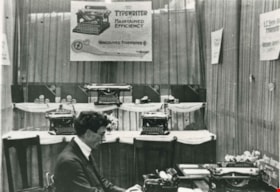
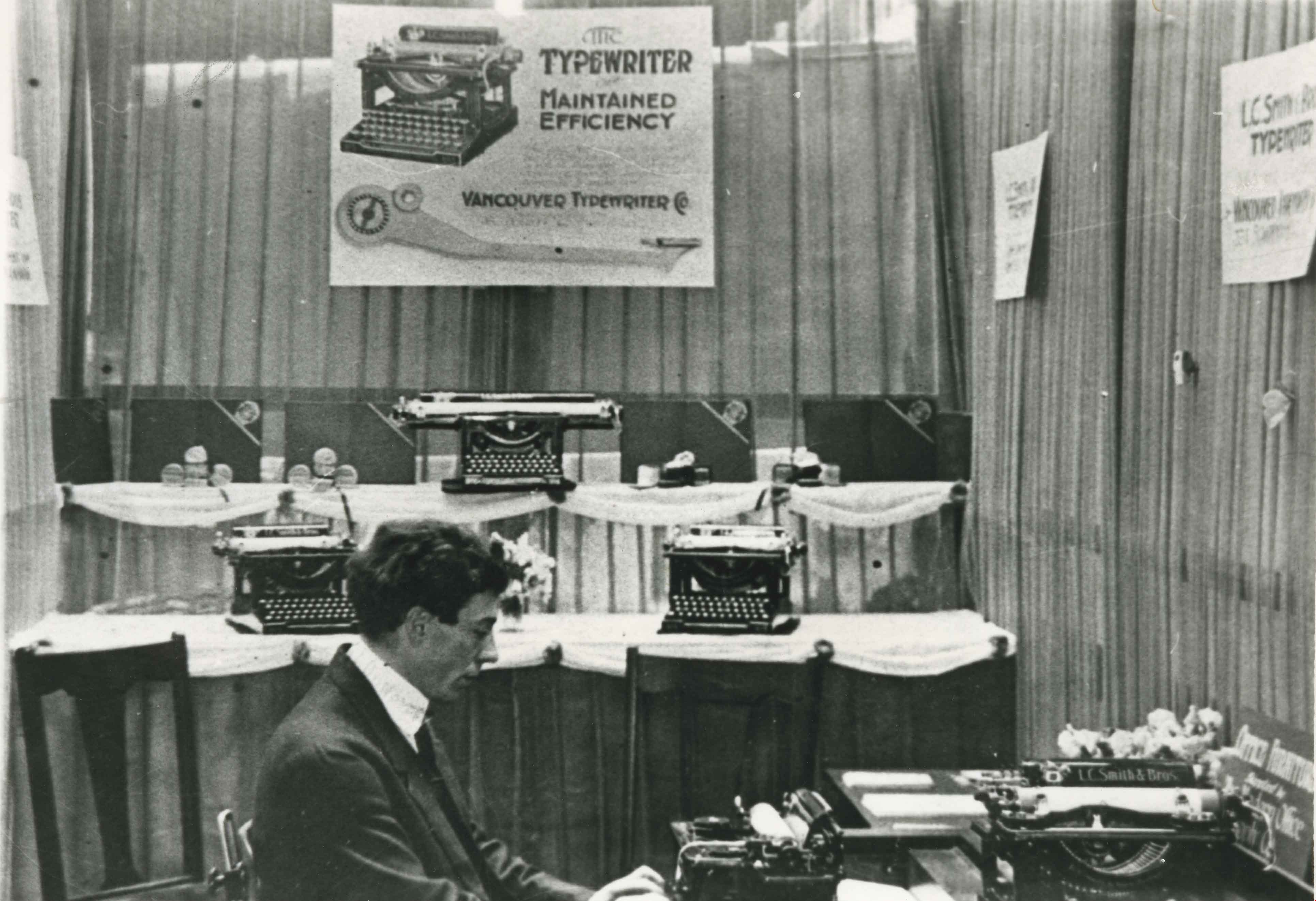
L.C. Smith Typewriter
https://search.heritageburnaby.ca/link/archivedescription35587
- Repository
- City of Burnaby Archives
- Date
- 1910 (date of original), copied 1986
- Collection/Fonds
- Burnaby Historical Society fonds
- Description Level
- Item
- Physical Description
- 1 photograph : b&w ; 12.7 x 17.8 cm print
- Scope and Content
- Photograph of George L. Donovan demonstrating the new L.C. Smith (later Smith-Corona) typewriter at the Vancouver Exhibition (later Pacific National Exhibition, PNE). He owned Vancouver Typewriters at 334 Seymour Street in Vancouver.
- Repository
- City of Burnaby Archives
- Date
- 1910 (date of original), copied 1986
- Collection/Fonds
- Burnaby Historical Society fonds
- Subseries
- Pioneer Tales subseries
- Physical Description
- 1 photograph : b&w ; 12.7 x 17.8 cm print
- Description Level
- Item
- Record No.
- 204-445
- Access Restriction
- No restrictions
- Reproduction Restriction
- No known restrictions
- Accession Number
- BHS1988-03
- Scope and Content
- Photograph of George L. Donovan demonstrating the new L.C. Smith (later Smith-Corona) typewriter at the Vancouver Exhibition (later Pacific National Exhibition, PNE). He owned Vancouver Typewriters at 334 Seymour Street in Vancouver.
- Subjects
- Advertising Medium - Signs and Signboards
- Exhibitions
- Written Communication Tools and Equipment - Typewriters
- Names
- Donovan, George L.
- Media Type
- Photograph
- Notes
- Title based on contents of photograph
Images
![Woman standing outside a Grocery Store, [191-?] thumbnail](/media/hpo/_Data/_BVM_Images/1984/1984_0051_0054_001.jpg?width=280)
Woman standing outside a Grocery Store
https://search.heritageburnaby.ca/link/museumdescription270
- Repository
- Burnaby Village Museum
- Date
- [191-?]
- Collection/Fonds
- Burnaby Village Museum Photograph collection
- Description Level
- Item
- Physical Description
- 1 photograph : b&w postcard ; 9.1 x 13.9 cm
- Scope and Content
- Photographic postcard of an unidentified woman standing outside a grocery store. The store is a unit on the ground level of a brick building, behind which another building is visible. The display window includes stacks of canned goods, and advertisements for Rowntree's Cocoa, butter and margarine.…
- Repository
- Burnaby Village Museum
- Collection/Fonds
- Burnaby Village Museum Photograph collection
- Description Level
- Item
- Physical Description
- 1 photograph : b&w postcard ; 9.1 x 13.9 cm
- Scope and Content
- Photographic postcard of an unidentified woman standing outside a grocery store. The store is a unit on the ground level of a brick building, behind which another building is visible. The display window includes stacks of canned goods, and advertisements for Rowntree's Cocoa, butter and margarine. The sign on top of the display window was partially blocked by putting something over the area while printing the photograph. It reads, "Family Grocer [blocked letters] & Corn Dealer."
- Subjects
- Buildings - Commercial - Grocery Stores
- Advertising Medium - Signs and Signboards
- Documentary Artifacts - Postcards
- Accession Code
- HV984.51.54
- Access Restriction
- No restrictions
- Reproduction Restriction
- No known restrictions
- Date
- [191-?]
- Media Type
- Photograph
- Scan Resolution
- 600
- Scan Date
- 2023-10-31
- Notes
- Title based on contents of photograph
Images
![Woman standing outside a Grocery Store, [191-?] thumbnail](/media/hpo/_Data/_BVM_Images/1984/1984_0051_0054_001.jpg)
![Douglas Road, Burnaby, [1908] thumbnail](/media/hpo/_Data/_Archives_Images/_Unrestricted/371/449-009.jpg?width=280)
Douglas Road, Burnaby
https://search.heritageburnaby.ca/link/archivedescription38514
- Repository
- City of Burnaby Archives
- Date
- [1908]
- Collection/Fonds
- Burnaby Historical Society fonds
- Description Level
- Item
- Physical Description
- 1 photograph : sepia postcard ; 8.8 x 14 cm
- Scope and Content
- Photographic postcard taken looking northwest along Douglas Road (now Canada Way) near Stanley Street. Two unidentified people are standing next to a wooden fence running alongside the road (above Lubbock's Creek) and a number of houses (including the Sprott house) are visible in the background. To…
- Repository
- City of Burnaby Archives
- Date
- [1908]
- Collection/Fonds
- Burnaby Historical Society fonds
- Subseries
- Photographs subseries
- Physical Description
- 1 photograph : sepia postcard ; 8.8 x 14 cm
- Description Level
- Item
- Record No.
- 449-009
- Access Restriction
- No restrictions
- Reproduction Restriction
- No known restrictions
- Accession Number
- BHS2007-04
- Scope and Content
- Photographic postcard taken looking northwest along Douglas Road (now Canada Way) near Stanley Street. Two unidentified people are standing next to a wooden fence running alongside the road (above Lubbock's Creek) and a number of houses (including the Sprott house) are visible in the background. To the right is Burnaby Lake. Stamped at the top of the postcard is "Douglas Road, Burnaby / New Westminster BC."
- Subjects
- Geographic Features - Lakes and Ponds
- Documentary Artifacts - Postcards
- Geographic Features - Roads
- Media Type
- Photograph
- Geographic Access
- Douglas Road
- Stanley Street
- Canada Way
- Deer Lake
- Historic Neighbourhood
- Burnaby Lake (Historic Neighbourhood)
- Planning Study Area
- Lakeview-Mayfield Area
Images
![Douglas Road, Burnaby, [1908] thumbnail](/media/hpo/_Data/_Archives_Images/_Unrestricted/371/449-009.jpg)
![Edith Clayton Outside Burnaby Lake Store, [1913] thumbnail](/media/hpo/_Data/_Archives_Images/_Unrestricted/477/477-201.jpg?width=280)
Edith Clayton Outside Burnaby Lake Store
https://search.heritageburnaby.ca/link/archivedescription38882
- Repository
- City of Burnaby Archives
- Date
- [1913]
- Collection/Fonds
- Peers Family and Hill Family fonds
- Description Level
- Item
- Physical Description
- 1 photograph : sepia ; 8.2 x 12.5 cm on page 14 x 17.5 cm (pasted in album)
- Scope and Content
- Photograph of Edith Clayton standing on the boarded sidewalk outside the Burnaby Lake Store. The photograph was taken looking along Douglas Road (later, Canada Way), towards New Westminster. Edith is dressed in a winter coat with scarf, mittens and hat.
- Repository
- City of Burnaby Archives
- Date
- [1913]
- Collection/Fonds
- Peers Family and Hill Family fonds
- Physical Description
- 1 photograph : sepia ; 8.2 x 12.5 cm on page 14 x 17.5 cm (pasted in album)
- Description Level
- Item
- Record No.
- 477-201
- Access Restriction
- No restrictions
- Reproduction Restriction
- No known restrictions
- Accession Number
- 2007-12
- Scope and Content
- Photograph of Edith Clayton standing on the boarded sidewalk outside the Burnaby Lake Store. The photograph was taken looking along Douglas Road (later, Canada Way), towards New Westminster. Edith is dressed in a winter coat with scarf, mittens and hat.
- Media Type
- Photograph
- Notes
- Title based on caption accompanying photograph
- Geographic Access
- Sperling Avenue
- Douglas Road
- Canada Way
- Historic Neighbourhood
- Burnaby Lake (Historic Neighbourhood)
- Planning Study Area
- Morley-Buckingham Area
Images
![Edith Clayton Outside Burnaby Lake Store, [1913] thumbnail](/media/hpo/_Data/_Archives_Images/_Unrestricted/477/477-201.jpg)

Government Road
https://search.heritageburnaby.ca/link/archivedescription35567
- Repository
- City of Burnaby Archives
- Date
- 1912 (date of original), copied 1986
- Collection/Fonds
- Burnaby Historical Society fonds
- Description Level
- Item
- Physical Description
- 1 photograph : b&w ; 12.7 x 17.8 cm print
- Scope and Content
- Photograph looking east on Government Road from the Haddon family house. One of the men in the photo is Robert Haddon. The other two people are unidentified. Note the loose gravel roadway and the bridge over Eagle Creek.
- Repository
- City of Burnaby Archives
- Date
- 1912 (date of original), copied 1986
- Collection/Fonds
- Burnaby Historical Society fonds
- Subseries
- Pioneer Tales subseries
- Physical Description
- 1 photograph : b&w ; 12.7 x 17.8 cm print
- Description Level
- Item
- Record No.
- 204-425
- Access Restriction
- No restrictions
- Reproduction Restriction
- No known restrictions
- Accession Number
- BHS1988-03
- Scope and Content
- Photograph looking east on Government Road from the Haddon family house. One of the men in the photo is Robert Haddon. The other two people are unidentified. Note the loose gravel roadway and the bridge over Eagle Creek.
- Names
- Haddon, Robert
- Media Type
- Photograph
- Notes
- Title based on contents of photograph
- Geographic Access
- Eagle Creek
- Government Road
- Historic Neighbourhood
- Lozells (Historic Neighbourhood)
- Planning Study Area
- Government Road Area
Images

![Men riding bicycles, [1914] thumbnail](/media/hpo/_Data/_BVM_Images/1971/197200110015.jpg?width=280)
Men riding bicycles
https://search.heritageburnaby.ca/link/museumdescription3101
- Repository
- Burnaby Village Museum
- Date
- [1914]
- Collection/Fonds
- Burnaby Village Museum Photograph collection
- Description Level
- Item
- Physical Description
- 1 photograph : b&w glass negative ; 16.4 x 21.3 cm
- Scope and Content
- Photograph of a paved road lined with electric poles on both sides and a wood plank sidewalk on one side of the road. There are two men in suits and bowler hats riding bicycles and another man in suit and bowler hat standing on the sidewalk. The sun is casting long shadows from the left side of the…
- Repository
- Burnaby Village Museum
- Collection/Fonds
- Burnaby Village Museum Photograph collection
- Description Level
- Item
- Physical Description
- 1 photograph : b&w glass negative ; 16.4 x 21.3 cm
- Scope and Content
- Photograph of a paved road lined with electric poles on both sides and a wood plank sidewalk on one side of the road. There are two men in suits and bowler hats riding bicycles and another man in suit and bowler hat standing on the sidewalk. The sun is casting long shadows from the left side of the photograph. An earlier catalogue record from 1988 conjectures that the photograph may be of Kingsway in Burnaby, possibly near Gilley looking east towards Griffiths Avenue. The record also dates the negative, ca. 1914.
- Geographic Access
- Kingsway
- Griffiths Avenue
- Accession Code
- HV972.11.15
- Access Restriction
- No restrictions
- Reproduction Restriction
- No known restrictions
- Date
- [1914]
- Media Type
- Photograph
- Historic Neighbourhood
- Edmonds (Historic Neighbourhood)
- Planning Study Area
- Kingsway-Beresford Area
- Scan Resolution
- 300
- Scan Date
- 14/8/2006
- Scale
- 100
- Notes
- Title based on contents of photograph
- 1 b&w contact print accompanying negative
Images
![Men riding bicycles, [1914] thumbnail](/media/hpo/_Data/_BVM_Images/1971/197200110015.jpg)
Interview with Alekxos Sarter by Kathy Bossort October 16, 2015 - Track 3
https://search.heritageburnaby.ca/link/oralhistory579
- Repository
- City of Burnaby Archives
- Date Range
- 1910-1960
- Length
- 0:21:54
- Summary
- This portion of the interview is about Alekxos Sarter’s historical overview of early public recreation, and intentions to set aside parkland, on Burnaby Mountain; Acting-Commissioner Richard Bolton’s signing of By Law 1772 that created Barnet Mountain Park in 1942; and her explanation about the fun…
- Repository
- City of Burnaby Archives
- Summary
- This portion of the interview is about Alekxos Sarter’s historical overview of early public recreation, and intentions to set aside parkland, on Burnaby Mountain; Acting-Commissioner Richard Bolton’s signing of By Law 1772 that created Barnet Mountain Park in 1942; and her explanation about the function and kinds of park dedications used in Burnaby.
- Date Range
- 1910-1960
- Length
- 0:21:54
- Geographic Access
- Burnaby Mountain Conservation Area
- Interviewer
- Bossort, Kathy
- Interview Date
- October 16, 2015
- Scope and Content
- Recording is of an interview with Alekxos Sarter conducted by Kathy Bossort. Alekxos Sarter was one of 23 participants interviewed as part of the Community Heritage Commission’s Burnaby Mountain Oral History Project. The interview is mainly about the history of setting aside parkland on Burnaby Mountain from Alekxos Sarter’s perspective and experience as employee in the City of Burnaby Parks, Recreation and Cultural Services. The interview provides an excellent explanation of the history and function of kinds of park dedications used by the City of Burnaby; an overview of issues around including the Trans Mountain tank farm in the conservation area; and the background to the land use and ownership disagreement between the City of Burnaby and Simon Fraser University, its resolution, and the subsequent development of SFU’s UniverCity. Alekxos Sarter talks about Richard Bolton, Burnaby’s Acting-Commissioner who was responsible for dedicating the first park on Burnaby Mountain in 1942, and the creation of a park named after him in UniverCity.
- Biographical Notes
- Alekxos Sarter was born in Vancouver in 1961, to Daine and Kasandra Sarter. She grew up in North Vancouver and since 1994 has lived on a sailboat in False Creek. After attending UBC where she studied landscape architecture, she was hired by the City of Burnaby Parks, Recreation and Cultural Services in 1986. Working first in parks design, Alekxos quickly moved into parks planning, her preferred career. As Research Officer she covers research, planning, public consultation, parks and facility inventory, parkland acquisition, among other duties.
- Total Tracks
- 9
- Total Length
- 2:20:47
- Interviewee Name
- Sarter, Alekxos T.
- Interview Location
- City of Burnaby Parks, Recreation and Cultural Services meeting room
- Interviewer Bio
- Kathy Bossort is a retired archivist living in Ladner, BC. She worked at the Delta Museum and Archives after graduating from SLAIS (UBC) in 2001 with Masters degrees in library science and archival studies. Kathy grew up in Calgary, Alberta, and, prior to this career change, she lived in the West Kootenays, earning her living as a cook for BC tourist lodges and work camps. She continues to be interested in oral histories as a way to fill the gaps in the written record and bring richer meaning to history.
- Collection/Fonds
- Community Heritage Commission Special Projects fonds
- Media Type
- Sound Recording
Audio Tracks
Track three of interview with Alekxos Sarter
Track three of interview with Alekxos Sarter
https://search.heritageburnaby.ca/media/hpo/_Data/_Archives_Oral_Histories/_Unrestricted/MSS196-005/MSS196-005_Track_3.mp3Interview with Basil Luksun and Jack Belhouse by Kathy Bossort November 24, 2015 - Track 2
https://search.heritageburnaby.ca/link/oralhistory628
- Repository
- City of Burnaby Archives
- Date Range
- 1913-2015
- Length
- 0:19:24
- Summary
- This portion of the interview is about Basil Luksun and Jack Belhouse talking about the history of setting aside parkland on Burnaby Mountain beginning in 1942 with By-Law 1772; the kinds of park dedications used by the City and shift in nature of dedications to accommodate long range park planning…
- Repository
- City of Burnaby Archives
- Summary
- This portion of the interview is about Basil Luksun and Jack Belhouse talking about the history of setting aside parkland on Burnaby Mountain beginning in 1942 with By-Law 1772; the kinds of park dedications used by the City and shift in nature of dedications to accommodate long range park planning; and looking at the big picture policy and programs for land assembly for major open spaces and linkages.
- Date Range
- 1913-2015
- Length
- 0:19:24
- Subjects
- Geographic Features - Parks
- Planning
- Geographic Access
- Burnaby Mountain Conservation Area
- Interviewer
- Bossort, Kathy
- Interview Date
- November 24, 2015
- Scope and Content
- Recording is of an interview with Basil Luksun and Jack Belhouse conducted by Kathy Bossort. Basil Luksun and Jack Belhouse were two of 23 participants interviewed as part of the Community Heritage Commission’s Burnaby Mountain Oral History Project. The interview is mainly about the history of setting aside parkland by dedication on Burnaby Mountain, the 1974/76 delineation of the conservation area on Burnaby Mountain, and the dispute between Burnaby and Simon Fraser University over land ownership and control on Burnaby Mountain, as discussed by two retired participants in these events from the City of Burnaby’s Planning and Building Department, Basil Luksun and Jack Belhouse. They also talk about their interaction with the public in developing policies, particularly for the 1974 report “The Public Meetings - Phase One”, and the importance of a strong policy base for long range planning and the patience needed to assemble land for large parks. They talk as well about their careers, their close working relationship in the department, and the cooperation between City and SFU staff in the development of UniverCity.
- Biographical Notes
- Basil Luksun was born and educated in South Africa, immigrating to Canada and Burnaby in 1972 to escape the harmful effects of apartheid. He holds a BSc degree from the University of Cape Town and a Post-Graduate Diploma in Town Planning from the University of Witwatersrand. He joined the City of Burnaby’s Planning and Building Department in 1973, working his way up through the organization to Director of the department before retiring after 39 years in 2012. When he started work in the 1970s, the City of Burnaby was focusing on green space planning projects and he takes great pride in these projects as well as the city’s focus on long-term planning. Basil lived in the Capital Hill area from 1972 to 1990. He currently resides in Vancouver and has two sons, Warren and Derek. Jack Belhouse was born in 1946 in Vancouver and attended UBC, York University and SFU (1965-1972), majoring in urban geography. He began working in Burnaby’s planning department as a summer student in 1968, and was offered a full-time position when he graduated from university. He became Director of the Planning and Building Department before retiring after 38 years with the city in 2006. He and Basil Luksun worked closely together in long range planning in the department. Jack lives in Coquitlam with his wife Linda and has two children, Brad and Lori.
- Total Tracks
- 8
- Total Length
- 1:58:23
- Interviewee Name
- Luksun, Basil
- Belhouse, Jack
- Interview Location
- Basil Luksun's home in Vancouver
- Interviewer Bio
- Kathy Bossort is a retired archivist living in Ladner, BC. She worked at the Delta Museum and Archives after graduating from SLAIS (UBC) in 2001 with Masters degrees in library science and archival studies. Kathy grew up in Calgary, Alberta, and, prior to this career change, she lived in the West Kootenays, earning her living as a cook for BC tourist lodges and work camps. She continues to be interested in oral histories as a way to fill the gaps in the written record and bring richer meaning to history.
- Collection/Fonds
- Community Heritage Commission Special Projects fonds
- Media Type
- Sound Recording
Audio Tracks
Track two of interview with Basil Luksun and Jack Belhouse
Track two of interview with Basil Luksun and Jack Belhouse
https://search.heritageburnaby.ca/media/hpo/_Data/_Archives_Oral_Histories/_Unrestricted/MSS196-012/MSS196-012_Track_2.mp3Interview with Rick Sporns by Kathy Bossort October 30, 2015 - Track 4
https://search.heritageburnaby.ca/link/oralhistory606
- Repository
- City of Burnaby Archives
- Date Range
- 1900-2015
- Length
- 0:17:11
- Summary
- This portion of the interview is about Rick Sporn’s discussion of the value of natural areas to Burnaby, the city’s history of protecting green spaces, and the complementary role the Pavilion area plays in the Burnaby Mountain Conservation Area. He talks about how the rose garden and “Playground of…
- Repository
- City of Burnaby Archives
- Summary
- This portion of the interview is about Rick Sporn’s discussion of the value of natural areas to Burnaby, the city’s history of protecting green spaces, and the complementary role the Pavilion area plays in the Burnaby Mountain Conservation Area. He talks about how the rose garden and “Playground of the Gods” sculptures (Kamui Mintara) help Pavilion area visitors more fully appreciate the mountain setting. He also talks about the history of the construction of the Kamui Mintara sculptures.
- Date Range
- 1900-2015
- Length
- 0:17:11
- Names
- Burnaby Mountain Centennial Rose Garden
- Burnaby Mountain Centennial Park
- Burnaby Mountain Conservation Area
- Kamui Mintara
- Central Park
- Geographic Access
- Burnaby Mountain Conservation Area
- Interviewer
- Bossort, Kathy
- Interview Date
- October 30, 2015
- Scope and Content
- Recording is of an interview with Rick Sporns conducted by Kathy Bossort. Rick Sporns was one of 23 participants interviewed as part of the Community Heritage Commission’s Burnaby Mountain Oral History Project. The interview is mainly about Rick Sporn’s description of the history and design of Burnaby Mountain Centennial Rose Garden and the significance of the Centennial Pavilion area in the Burnaby Mountain Conservation Area. Rick Sporns also talks about his career with the City of Burnaby’s Parks, Recreation and Cultural Services, management of Burnaby Mountain Conservation Area, and the value of natural areas to Burnaby.
- Biographical Notes
- Richard Sporns was born in 1957 in Daly Municipality, Manitoba, to Ulrich and Charlotte Sporns. The family moved to the Burquitlam Area of Burnaby in about 1965. Rick Sporns obtained his BSc degree in biology at SFU and a degree in landscape architecture at UBC. In 1985 he began his career in the City of Burnaby’s Park, Recreation and Cultural Services department where he currently is Assistant Manager - Parks Design. Rick was responsible for designing Burnaby Mountain Centennial Rose Garden, a legacy project proposed by Mark Stockdale to commemorate Burnaby’s 1992 Centennial. The rose garden opened to the public July 18, 1992.
- Total Tracks
- 6
- Total Length
- 1:01:40
- Interviewee Name
- Sporns, Richard "Rick"
- Interview Location
- City of Burnaby Parks, Recreation and Cultural Services meeting room
- Interviewer Bio
- Kathy Bossort is a retired archivist living in Ladner, BC. She worked at the Delta Museum and Archives after graduating from SLAIS (UBC) in 2001 with Masters degrees in library science and archival studies. Kathy grew up in Calgary, Alberta, and, prior to this career change, she lived in the West Kootenays, earning her living as a cook for BC tourist lodges and work camps. She continues to be interested in oral histories as a way to fill the gaps in the written record and bring richer meaning to history.
- Collection/Fonds
- Community Heritage Commission Special Projects fonds
- Media Type
- Sound Recording
Audio Tracks
Track four of interview with Rick Sporns
Track four of interview with Rick Sporns
https://search.heritageburnaby.ca/media/hpo/_Data/_Archives_Oral_Histories/_Unrestricted/MSS196-008/MSS196-008_Track_4.mp3![Andrew Johnson house and surrounding property, [1913] thumbnail](/media/hpo/_Data/_BVM_Images/1994/1994_0015_0003_002.jpg?width=280)
Andrew Johnson house and surrounding property
https://search.heritageburnaby.ca/link/museumdescription1189
- Repository
- Burnaby Village Museum
- Date
- [1913]
- Collection/Fonds
- Burnaby Village Museum Photograph collection
- Description Level
- Item
- Physical Description
- 1 photograph : b&w panorama ; 13.5 x 34.5 cm mounted on mattboard 20 x 38 cm
- Scope and Content
- Photograph of the Andrew M. Johnson house "Glenedward" and surrounding property at Kingsway and Royal Oak Avenue. Andrew Johnson built the house around 1911, then occupied the residence until his death in 1934. His wife sold the property in 1943, after which, the place operated as a funeral home un…
- Repository
- Burnaby Village Museum
- Collection/Fonds
- Burnaby Village Museum Photograph collection
- Description Level
- Item
- Physical Description
- 1 photograph : b&w panorama ; 13.5 x 34.5 cm mounted on mattboard 20 x 38 cm
- Material Details
- Panorama was created by printing two negatives and joining them together
- Scope and Content
- Photograph of the Andrew M. Johnson house "Glenedward" and surrounding property at Kingsway and Royal Oak Avenue. Andrew Johnson built the house around 1911, then occupied the residence until his death in 1934. His wife sold the property in 1943, after which, the place operated as a funeral home until 1980 or 1981. The building was then purchased by Wales McLelland development company, then went through a series of restaurant owners' hands.
- Geographic Access
- Kingsway
- Royal Oak Avenue
- Street Address
- 5152 Kingsway
- Accession Code
- BV994.15.3
- Access Restriction
- No restrictions
- Reproduction Restriction
- No known restrictions
- Date
- [1913]
- Media Type
- Photograph
- Historic Neighbourhood
- Central Park (Historic Neighbourhood)
- Planning Study Area
- Marlborough Area
- Scan Resolution
- 600
- Scan Date
- 2024-04-23
- Notes
- Title based on contents of photograph
Images
![Andrew Johnson house and surrounding property, [1913] thumbnail](/media/hpo/_Data/_BVM_Images/1994/1994_0015_0003_002.jpg)

Automobile on Kinnee Street
https://search.heritageburnaby.ca/link/archivedescription35060
- Repository
- City of Burnaby Archives
- Date
- 1915
- Collection/Fonds
- Burnaby Historical Society fonds
- Description Level
- Item
- Physical Description
- 1 photograph : b&w ; 11.0 x 6.2 cm
- Scope and Content
- Photograph of an automobile on Kinnee Street with the Patterson Avenue pump house and tank in the background. An annotation on the back of the photograph reads, "Water tank at Patterson Ave near the track in the Central Park (Ball park), 1915. / The roadway was Kinnee Ave which is Beresford today."
- Repository
- City of Burnaby Archives
- Date
- 1915
- Collection/Fonds
- Burnaby Historical Society fonds
- Subseries
- Pitman family subseries
- Physical Description
- 1 photograph : b&w ; 11.0 x 6.2 cm
- Description Level
- Item
- Record No.
- 186-004
- Access Restriction
- No restrictions
- Reproduction Restriction
- No known restrictions
- Accession Number
- BHS1986-35
- Scope and Content
- Photograph of an automobile on Kinnee Street with the Patterson Avenue pump house and tank in the background. An annotation on the back of the photograph reads, "Water tank at Patterson Ave near the track in the Central Park (Ball park), 1915. / The roadway was Kinnee Ave which is Beresford today."
- Media Type
- Photograph
- Notes
- Title based on contents of photograph
- Geographic Access
- Beresford Street
- Historic Neighbourhood
- Central Park (Historic Neighbourhood)
- Planning Study Area
- Maywood Area
Images

![Barnet Road, [1914 or 1915] thumbnail](/media/hpo/_Data/_Archives_Images/_Unrestricted/001/044-001.jpg?width=280)
Barnet Road
https://search.heritageburnaby.ca/link/archivedescription34541
- Repository
- City of Burnaby Archives
- Date
- [1914 or 1915]
- Collection/Fonds
- Burnaby Historical Society fonds
- Description Level
- Item
- Physical Description
- 1 photograph : b&w ; 16.4 x 21.3 cm
- Scope and Content
- Photograph of Barnet Road at North Road. Street signs on the left side of the photograph read, "North Ave" and "Barnet Road." A person on a motorbike or bicycle can be seen on the road in the distance. Utility poles are along the road.
- Repository
- City of Burnaby Archives
- Date
- [1914 or 1915]
- Collection/Fonds
- Burnaby Historical Society fonds
- Subseries
- Photographs subseries
- Physical Description
- 1 photograph : b&w ; 16.4 x 21.3 cm
- Description Level
- Item
- Record No.
- 044-001
- Access Restriction
- No restrictions
- Reproduction Restriction
- No known restrictions
- Accession Number
- BHS2007-04
- Scope and Content
- Photograph of Barnet Road at North Road. Street signs on the left side of the photograph read, "North Ave" and "Barnet Road." A person on a motorbike or bicycle can be seen on the road in the distance. Utility poles are along the road.
- Subjects
- Geographic Features - Roads
- Media Type
- Photograph
- Notes
- Title based on contents of photograph
- Geographic Access
- Barnet Road
- North Road
- Planning Study Area
- Burnaby Mountain Area
Images
![Barnet Road, [1914 or 1915] thumbnail](/media/hpo/_Data/_Archives_Images/_Unrestricted/001/044-001.jpg)
![Barnet Road and North Avenue, [1914] thumbnail](/media/hpo/_Data/_BVM_Images/1971/197200110019.jpg?width=280)
Barnet Road and North Avenue
https://search.heritageburnaby.ca/link/museumdescription3105
- Repository
- Burnaby Village Museum
- Date
- [1914]
- Collection/Fonds
- Burnaby Village Museum Photograph collection
- Description Level
- Item
- Physical Description
- 1 photograph : b&w glass negative ; 16.0 x 20.9 cm
- Scope and Content
- Photograph of Barnet Road, a dirt road at the time of the photograph, from North Road. There is a sign post in the foreground to the left that indicates the crossing is "NORTH AVE" and "BARNET RD". On the sign post a provincial notice is tacked on. There are electric posts along one side of Barnet …
- Repository
- Burnaby Village Museum
- Collection/Fonds
- Burnaby Village Museum Photograph collection
- Description Level
- Item
- Physical Description
- 1 photograph : b&w glass negative ; 16.0 x 20.9 cm
- Scope and Content
- Photograph of Barnet Road, a dirt road at the time of the photograph, from North Road. There is a sign post in the foreground to the left that indicates the crossing is "NORTH AVE" and "BARNET RD". On the sign post a provincial notice is tacked on. There are electric posts along one side of Barnet Road, and further down the road is an unidentified man riding a motorcycle or a bicycle. According to an earlier catalogue record from 1988, the view is looking East, and the mountain rising in the background is Burnaby Mountain. The record also dates the negative ca. 1914
- Subjects
- Geographic Features - Roads
- Geographic Access
- Barnet Road
- North Road
- Accession Code
- HV972.11.19
- Access Restriction
- No restrictions
- Reproduction Restriction
- No known restrictions
- Date
- [1914]
- Media Type
- Photograph
- Planning Study Area
- Burnaby Mountain Area
- Scan Resolution
- 300
- Scan Date
- 14/8/2006
- Scale
- 100
- Notes
- Title based on contents of photograph
- 1 b&w contact print accompanying negative
Images
![Barnet Road and North Avenue, [1914] thumbnail](/media/hpo/_Data/_BVM_Images/1971/197200110019.jpg)

Bob and Olive Urquhart beside Boundary Road
https://search.heritageburnaby.ca/link/archivedescription36759
- Repository
- City of Burnaby Archives
- Date
- March 19, 1913 (date of original), copied 1992
- Collection/Fonds
- Burnaby Historical Society fonds
- Description Level
- Item
- Physical Description
- 1 photograph : b&w ; 10 x 8 cm print
- Scope and Content
- Photograph of Bob and Olive Urquhart soon after their marriage, (they were married March 15). Note the new wood planking on Boundary Road and the train track crossing sign past the house in the distance for the Burnaby Lake Interurban tram line. This photograph was taken looking north on Boundary…
- Repository
- City of Burnaby Archives
- Date
- March 19, 1913 (date of original), copied 1992
- Collection/Fonds
- Burnaby Historical Society fonds
- Subseries
- Burnaby Centennial Anthology subseries
- Physical Description
- 1 photograph : b&w ; 10 x 8 cm print
- Description Level
- Item
- Record No.
- 315-114
- Access Restriction
- No restrictions
- Reproduction Restriction
- No known restrictions
- Accession Number
- BHS1994-04
- Scope and Content
- Photograph of Bob and Olive Urquhart soon after their marriage, (they were married March 15). Note the new wood planking on Boundary Road and the train track crossing sign past the house in the distance for the Burnaby Lake Interurban tram line. This photograph was taken looking north on Boundary Road just south of the railway tracks.
- Subjects
- Geographic Features - Roads
- Media Type
- Photograph
- Notes
- Title based on contents of photograph
- Geographic Access
- Boundary Road
- Myrtle Street
- Historic Neighbourhood
- Broadview (Historic Neighbourhood)
- Planning Study Area
- West Central Valley Area
Images
