More like 'Lochdale Merchants Association petition'
Narrow Results By
Subject
- Accidents - Automobile Accidents 1
- Advertising Medium 3
- Advertising Medium - Signs and Signboards 83
- Aerial Photographs 26
- Agricultural Tools and Equipment - Plows 3
- Agriculture 2
- Agriculture - Crops 2
- Agriculture - Farms 48
- Agriculture - Fruit and Berries 5
- Agriculture - Poultry 4
- Animals - Birds 2
- Animals - Cats 5
![Habitat For Humanity construction site, [2003] thumbnail](/media/hpo/_Data/_Archives_Images/_Unrestricted/535/535-2047.jpg?width=280)
Habitat For Humanity construction site
https://search.heritageburnaby.ca/link/archivedescription96366
- Repository
- City of Burnaby Archives
- Date
- [2003]
- Collection/Fonds
- Burnaby NewsLeader photograph collection
- Description Level
- Item
- Physical Description
- 1 photograph (tiff) : col.
- Scope and Content
- Photograph of Simon Gould, the chair of the construction committee for Habitat For Humanity, leaning against a shovel. Gould stands in the foundation and construction site for Habitat for Humanity's second townhouse project. A number of other townhouses are visible in the background.
- Repository
- City of Burnaby Archives
- Date
- [2003]
- Collection/Fonds
- Burnaby NewsLeader photograph collection
- Physical Description
- 1 photograph (tiff) : col.
- Description Level
- Item
- Record No.
- 535-2047
- Access Restriction
- No restrictions
- Reproduction Restriction
- No restrictions
- Accession Number
- 2018-12
- Scope and Content
- Photograph of Simon Gould, the chair of the construction committee for Habitat For Humanity, leaning against a shovel. Gould stands in the foundation and construction site for Habitat for Humanity's second townhouse project. A number of other townhouses are visible in the background.
- Subjects
- Construction
- Buildings - Residential
- Buildings - Residential - Townhouses
- Organizations - Charities
- Media Type
- Photograph
- Photographer
- Bartel, Mario
- Notes
- Title based on caption
- Collected by editorial for use in a March 2003 issue of the Burnaby NewsLeader
- Caption from metadata: "Simon Gould, the chair of construction committee for Habitat For Humanity, surveys the foundation which is being prepared for their second townhouse project. The four units should be ready for their new owners by December."
Images
![Habitat For Humanity construction site, [2003] thumbnail](/media/hpo/_Data/_Archives_Images/_Unrestricted/535/535-2047.jpg)
![Habitat for Humanity development, [2001] thumbnail](/media/hpo/_Data/_Archives_Images/_Unrestricted/535/535-2970-3.jpg?width=280)
Habitat for Humanity development
https://search.heritageburnaby.ca/link/archivedescription97695
- Repository
- City of Burnaby Archives
- Date
- [2001]
- Collection/Fonds
- Burnaby NewsLeader photograph collection
- Description Level
- File
- Physical Description
- 8 photographs (tiff) : col.
- Scope and Content
- File contains photographs of a Habitat for Humanity development in Burnaby and the volunteers at work on the site. Photographs depict volunteers engaged in construction and posing in and around the under-construction townhouses, and close-ups of the muddy ground and a sign signed by volunteers.
- Repository
- City of Burnaby Archives
- Date
- [2001]
- Collection/Fonds
- Burnaby NewsLeader photograph collection
- Physical Description
- 8 photographs (tiff) : col.
- Description Level
- File
- Record No.
- 535-2970
- Access Restriction
- No restrictions
- Reproduction Restriction
- No restrictions
- Accession Number
- 2018-12
- Scope and Content
- File contains photographs of a Habitat for Humanity development in Burnaby and the volunteers at work on the site. Photographs depict volunteers engaged in construction and posing in and around the under-construction townhouses, and close-ups of the muddy ground and a sign signed by volunteers.
- Subjects
- Buildings - Residential
- Buildings - Residential - Townhouses
- Construction
- Persons - Volunteers
- Organizations - Charities
- Media Type
- Photograph
- Photographer
- Bartel, Mario
- Notes
- Title based on caption
- Collected by editorial for use in a December 2001 issue of the Burnaby NewsLeader
- Caption from metadata for 535-2970-1: "Peter Emlick and Peri Hansen are eagerly anticipating moving into their own home at Burnaby's Habitat for Humanity development. The couple were amongst the first volunteers at the project, and the first elligible buyers. Habitat for Humanity builds low-income housing for people who would otherwise be unable to afford to own their own homes. Most of the construction is done by volunteers."
- Caption from metadata for 535-2970-2: "Art Wosminity takes a break from drywall taping in one of the units."
- Caption from metadata for 535-2970-3: "Volunteers help clean up the site."
- Caption from metadata for 535-2970-4: "Peri Hansen says she's most thrilled about "finally having a view" from the kitchen of her new home, still under construction at Burnaby's Habitat for Humanity. "
- Caption from metadata for 535-2970-5: "Mario Galdamez takes in the view from the deck of his townhouse unit at Burnaby's Habitat for Humanity."
- Caption from metadata for 535-2970-6: "Habitat for Humanity projects are built largely by volunteers who exchange "sweat equity" for the chance to live in the developments. But at Burnaby's Habitat for Humanity, on a recent Saturday after heavy Fall rains, Mitch Uh felt like he was giving "mud equity.""
- Caption from metadata for 535-2970-7: "Kerry MacLaren and Sandy Stephens sort through wood scraps at Burnaby's Habitat for Humanity project."
- Caption from metadata for 535-2970-8: "Volunteers at Buranby's Habitat for Humanity project leave behind their signatures on a sign in the worksite's lunch area."
- Geographic Access
- Government Street
- Street Address
- 8745 Government Street
- Historic Neighbourhood
- Burquitlam (Historic Neighbourhood)
- Planning Study Area
- Cameron Area
Images
![Habitat for Humanity development, [2001] thumbnail](/media/hpo/_Data/_Archives_Images/_Unrestricted/535/535-2970-3.jpg)
![Habitat for Humanity Government St. project, [2000] thumbnail](/media/hpo/_Data/_Archives_Images/_Unrestricted/535/535-1705-1.jpg?width=280)
Habitat for Humanity Government St. project
https://search.heritageburnaby.ca/link/archivedescription95935
- Repository
- City of Burnaby Archives
- Date
- [2000]
- Collection/Fonds
- Burnaby NewsLeader photograph collection
- Description Level
- File
- Physical Description
- 3 photographs (tiff) : col.
- Scope and Content
- File contains photographs of a Habitat for Humanity housing project being built on Government St. Photographs depict volunteers working on the construction of the project and the chair of the board posing with a pick axe.
- Repository
- City of Burnaby Archives
- Date
- [2000]
- Collection/Fonds
- Burnaby NewsLeader photograph collection
- Physical Description
- 3 photographs (tiff) : col.
- Description Level
- File
- Record No.
- 535-1705
- Access Restriction
- No restrictions
- Reproduction Restriction
- No restrictions
- Accession Number
- 2018-12
- Scope and Content
- File contains photographs of a Habitat for Humanity housing project being built on Government St. Photographs depict volunteers working on the construction of the project and the chair of the board posing with a pick axe.
- Media Type
- Photograph
- Photographer
- Bartel, Mario
- Notes
- Title based on caption
- Collected by editorial for use in a December 2000 issue of the Burnaby NewsLeader
- Caption from metadata for 535-1705-1: "Len Horton, one of the volunteer workers at the new Habitat for Humanity housing project, being built on Government St., digs a storm drainage trench."
- Caption from metadata for 535-1705-2: "Gloria Levi is the chair of the board of directors of the Habitat for Humanity project, being built on Government St., but she's not afraid to get her hands dirty."
- Caption from metadata for 535-1705-3: "Simon Gould volunteers his time to help construct the Habitat for Humanity project, being built on Government St."
- Geographic Access
- Government Street
- Historic Neighbourhood
- Burquitlam (Historic Neighbourhood)
- Planning Study Area
- Cameron Area
Images
![Habitat for Humanity Government St. project, [2000] thumbnail](/media/hpo/_Data/_Archives_Images/_Unrestricted/535/535-1705-1.jpg)
Interview with Edward Apps by Rod Fowler February 22, 1990 - Track 8
https://search.heritageburnaby.ca/link/oralhistory463
- Repository
- City of Burnaby Archives
- Date Range
- 1980-1990
- Length
- 00:08:00
- Summary
- This portion of the interview is about Ed Apps involvement in seniors organizations. He describes his involvement in a series of CMHC conferences in 1988, which culminated in the "Habitat" conference in Halifax, and a followup conference in Vancouver in 1990 about senior housing. In 1990 he was Pre…
- Repository
- City of Burnaby Archives
- Summary
- This portion of the interview is about Ed Apps involvement in seniors organizations. He describes his involvement in a series of CMHC conferences in 1988, which culminated in the "Habitat" conference in Halifax, and a followup conference in Vancouver in 1990 about senior housing. In 1990 he was President of the Council of Senior Citizens Organizations (COSCO), member of the CMHC Housing Committee, and on the Executive of the provincial Seniors Research and Resource group
- Date Range
- 1980-1990
- Length
- 00:08:00
- Interviewer
- Fowler, Rod
- Interview Date
- February 22, 1990
- Scope and Content
- Recording is of an interview with Edward Apps, conducted by Rod Fowler. Ed Apps was one of eleven participants interviewed as part of the SFU/Burnaby Centennial Committee's oral history series titled, "Voices of Burnaby". The interview is mainly about Ed Apps involvement in community groups, particularly his work in seniors organizations lobbying for seniors’ housing since his retirement, and views about the role of Rate Payer groups, unions and politics in the development of North and South Burnaby. He also talks about his origin in England, his war service, arrival with his wife Margaret in Burnaby in 1946, his work with the Burnaby School Board and for the local union, the location of some of the older schools, the history of his house, and briefly about his wife and children. To view “Narrow By” terms for each track expand this description and see “Notes”.
- Biographical Notes
- Edward Apps was born in 1918 in London, England, and grew up in Kent and Essex. In WWII he flew the third glider to land in Normandy on June 6th, 1944. He and his wife Margaret Hope (1915-1985) immigrated to British Columbia in 1946, joining his wife’s parents, who had immigrated earlier in 1939, in Burnaby Heights in North Burnaby. He worked for the Burnaby School Board as Foreman Painter, and served on CUPE Local 379 Executive, until his retirement in 1982. In 1948 Ed Apps bought his first lot, for $150.00, in the 4700 block on Georgia Street, building houses there and in the 4100 block before buying his present home, a ca.1900 farm building, in the same area in 1954. North Burnaby was “bush country and orchards” in the 1950s; his two sons played in the ravines; and the family used the tram system on Hastings and Boundary Road for transportation. Development of municipal services seemed slower in North than South Burnaby, and Ed Apps remembers the strong role Rate Payers groups had in creating local services and lobbying Municipal Council for provide services. After retirement Ed Apps became involved in several local and provincial seniors organizations, advocating for better housing, including serving on the Executives of the Network of Burnaby Seniors and the Council of Senior Citizens Organization, and was active in the provincial Seniors Research and Resource and CMHC Housing Committee. He also served on the Centennial Committee of Burnaby.
- Total Tracks
- 8
- Total Length
- 0:56:50
- Interviewee Name
- Apps, Ed
- Interviewer Bio
- Rod Fowler returned to university as a mature student in the 1980s after working about twenty years in the field of economics and computerization in business in England, Europe and Western Canada. He graduated with a BA from SFU in both History and Sociology in 1987, his MA degree in Geography in 1989, and his PhD in Cultural Geography at SFU. He taught courses in Geography, Sociology, History and Canadian Studies at several Lower Mainland colleges, before becoming a full time member of the Geography Department at Kwantlen University College.
- Collection/Fonds
- SFU/Burnaby Centennial Committee fonds
- Transcript Available
- Transcript available
- Media Type
- Sound Recording
- Web Notes
- Interviews were digitized in 2015 allowing them to be accessible on Heritage Burnaby. The digitization project was initiated by the Community Heritage Commission with support from City of Burnaby Council.
Audio Tracks
Track eight of interview with Ed Apps
Track eight of interview with Ed Apps
https://search.heritageburnaby.ca/media/hpo/_Data/_Archives_Oral_Histories/_Unrestricted/MSS187-015/MSS187-015_Track_8.mp3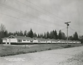
New Vista Society Project
https://search.heritageburnaby.ca/link/archivedescription34647
- Repository
- City of Burnaby Archives
- Date
- 1950
- Collection/Fonds
- Burnaby Historical Society fonds
- Description Level
- Item
- Physical Description
- 1 photograph : b&w ; 19.9 x 24.9 cm
- Scope and Content
- Photograph of the New Vista Society housing project #2 at 901 to 953 Vista Crescent (later renumbered 7593 to 7549 Vista Crescent).
- Repository
- City of Burnaby Archives
- Date
- 1950
- Collection/Fonds
- Burnaby Historical Society fonds
- Subseries
- Photographs subseries
- Physical Description
- 1 photograph : b&w ; 19.9 x 24.9 cm
- Description Level
- Item
- Record No.
- 080-002
- Access Restriction
- No restrictions
- Reproduction Restriction
- Reproduce for fair dealing purposes only
- Accession Number
- BHS2007-04
- Scope and Content
- Photograph of the New Vista Society housing project #2 at 901 to 953 Vista Crescent (later renumbered 7593 to 7549 Vista Crescent).
- Names
- New Vista Society
- Media Type
- Photograph
- Photographer
- Stride, Charles Edgar
- Notes
- Title based on contents of photograph
- Caption at bottom left of photograph, "New Vista Society's Project #2. 901 - 953 Vista Crescent, South Burnaby, B.C., 1950"
- Stamp and annotation on back of photograph reads, "Photo by The Stride Studios / 657 Columbia Street, New Westminster, BC" and "#6400-B"
- Geographic Access
- Vista Crescent
- Historic Neighbourhood
- Edmonds (Historic Neighbourhood)
- Planning Study Area
- Richmond Park Area
Images

![New Vista Society Project, [195-] thumbnail](/media/hpo/_Data/_Archives_Images/_Unrestricted/001/080-007.jpg?width=280)
New Vista Society Project
https://search.heritageburnaby.ca/link/archivedescription34652
- Repository
- City of Burnaby Archives
- Date
- [195-]
- Collection/Fonds
- Burnaby Historical Society fonds
- Description Level
- Item
- Physical Description
- 1 photograph : b&w ; 20.2 x 25.1 cm
- Scope and Content
- Photograph of a New Vista Society housing project.
- Repository
- City of Burnaby Archives
- Date
- [195-]
- Collection/Fonds
- Burnaby Historical Society fonds
- Subseries
- Photographs subseries
- Physical Description
- 1 photograph : b&w ; 20.2 x 25.1 cm
- Description Level
- Item
- Record No.
- 080-007
- Access Restriction
- No restrictions
- Reproduction Restriction
- Reproduce for fair dealing purposes only
- Accession Number
- BHS2007-04
- Scope and Content
- Photograph of a New Vista Society housing project.
- Names
- New Vista Society
- Media Type
- Photograph
- Photographer
- Stride, Charles Edgar
- Notes
- Title based on contents of photograph
- Stamp on back of photograph reads, "Photo by The Stride Studios / 657 Columbia Street, New Westminster, BC" and "#7458"
- Historic Neighbourhood
- East Burnaby (Historic Neighbourhood)
Images
![New Vista Society Project, [195-] thumbnail](/media/hpo/_Data/_Archives_Images/_Unrestricted/001/080-007.jpg)
![Cranberry Commons, [2002] thumbnail](/media/hpo/_Data/_Archives_Images/_Unrestricted/535/535-2517-1.jpg?width=280)
Cranberry Commons
https://search.heritageburnaby.ca/link/archivedescription96962
- Repository
- City of Burnaby Archives
- Date
- [2002]
- Collection/Fonds
- Burnaby NewsLeader photograph collection
- Description Level
- File
- Physical Description
- 2 photographs (tiff) : b&w and col.
- Scope and Content
- File contains photographs of Ronaye Mathew at Cranberry Commons, a cohousing development in North Burnaby that received an Environment Award from the City of Burnaby. Photographs depict Mathew in the development's courtyard and posing in the communal kitchen.
- Repository
- City of Burnaby Archives
- Date
- [2002]
- Collection/Fonds
- Burnaby NewsLeader photograph collection
- Physical Description
- 2 photographs (tiff) : b&w and col.
- Description Level
- File
- Record No.
- 535-2517
- Access Restriction
- No restrictions
- Reproduction Restriction
- No restrictions
- Accession Number
- 2018-12
- Scope and Content
- File contains photographs of Ronaye Mathew at Cranberry Commons, a cohousing development in North Burnaby that received an Environment Award from the City of Burnaby. Photographs depict Mathew in the development's courtyard and posing in the communal kitchen.
- Subjects
- Buildings - Residential - Apartments
- Buildings - Residential
- Buildings - Residential - Townhouses
- Media Type
- Photograph
- Photographer
- Bartel, Mario
- Notes
- Title based on caption
- Collected by editorial for use in a June 2002 issue of the Burnaby NewsLeader
- Caption from metadata for 535-2517-1: "Ronaye Mathew relaxes in the central courtyard at Cranberry Commons, a cohousing development in North Burnaby that's been honoured by the city with an Environment Award."
- Caption from metadata for 535-2517-2: "Ronaye Mathew enjoys a rare moment of peace in the communal kitchen at Cranberry Commons, a cohousing development in North Burnaby. At least three times a week, the kitchen is crowded for communal dinners. The development has been honored by the City with an Environment Award."
- Geographic Access
- Albert Street
- Street Address
- 4272 Albert Street
- Historic Neighbourhood
- Vancouver Heights (Historic Neighbourhood)
- Planning Study Area
- Burnaby Heights Area
Images
![Cranberry Commons, [2002] thumbnail](/media/hpo/_Data/_Archives_Images/_Unrestricted/535/535-2517-1.jpg)
6900 [and] 7000 bk Hastings St. / 7000 blk Pandora St. 200 [and] 300 blks Cliff Ave Burnaby
https://search.heritageburnaby.ca/link/archivedescription94205
- Repository
- City of Burnaby Archives
- Date
- November 1993 - December 1993
- Collection/Fonds
- Grover, Elliott & Co. Ltd. fonds
- Description Level
- File
- Physical Description
- 96 photographs : col. negatives ; 35 mm
- Scope and Content
- Photographs of various residential and commercial streets in Burnaby.
- Repository
- City of Burnaby Archives
- Date
- November 1993 - December 1993
- Collection/Fonds
- Grover, Elliott & Co. Ltd. fonds
- Physical Description
- 96 photographs : col. negatives ; 35 mm
- Description Level
- File
- Record No.
- 622-080
- Access Restriction
- No restrictions
- Reproduction Restriction
- No restrictions
- Accession Number
- 2017-39
- Scope and Content
- Photographs of various residential and commercial streets in Burnaby.
- Subjects
- Geographic Features - Roads
- Buildings - Residential - Apartments
- Buildings - Residential - Houses
- Buildings - Commercial
- Media Type
- Photograph
- Notes
- Transcribed title
- Title transcribed from envelope photographs were originally housed in
- File no. 93-455-B
- Note on negative envelope housing photographs 622-080-1 : 622-080-74 reads: "93-11-26 / Inlet Dr/Hastings, Bby, / 93-455-B"
- Note on negative envelope housing photographs 622-080-75 : 622-080-96 reads: "93-12-01 / Comp's / 93-455"
- Photographer identified as "K.H."
- Geographic Access
- Hastings Street
- Cliff Avenue
- Pandora Street

7530 Buller Avenue
https://search.heritageburnaby.ca/link/archivedescription98686
- Repository
- City of Burnaby Archives
- Date
- 2022
- Collection/Fonds
- Disappearing Burnaby collection
- Description Level
- Item
- Physical Description
- 1 photograph (jpeg) : col.
- Scope and Content
- Photograph of the exterior of a two-storey house located at 7530 Buller Avenue. The photograph depicts the house at dusk; the house stands behind a wooden fence and is surrounded by trees. The house was constructed in 1924 and was formerly known as "Ryverbrae," the William & Esther Burdick Residenc…
- Repository
- City of Burnaby Archives
- Date
- 2022
- Collection/Fonds
- Disappearing Burnaby collection
- Physical Description
- 1 photograph (jpeg) : col.
- Description Level
- Item
- Record No.
- 634-033
- Access Restriction
- No restrictions
- Reproduction Restriction
- No restrictions
- Accession Number
- 2022-14
- Scope and Content
- Photograph of the exterior of a two-storey house located at 7530 Buller Avenue. The photograph depicts the house at dusk; the house stands behind a wooden fence and is surrounded by trees. The house was constructed in 1924 and was formerly known as "Ryverbrae," the William & Esther Burdick Residence.
- Media Type
- Photograph
- Photographer
- Cheung, Nakita
- Notes
- Title taken from the associated blog post
- Associated blog post: https://disappearingburnaby.wordpress.com/2022/06/30/william-esther-burdick-residence/
- Geographic Access
- Buller Avenue
- Street Address
- 7530 Buller Avenue
- Historic Neighbourhood
- Alta Vista (Historic Neighbourhood)
- Planning Study Area
- Clinton-Glenwood Area
Images


Brookes family home, "Normanna"
https://search.heritageburnaby.ca/link/archivedescription35246
- Repository
- City of Burnaby Archives
- Date
- 1927
- Collection/Fonds
- Burnaby Historical Society fonds
- Description Level
- Item
- Physical Description
- 1 photograph : b&w ; 12.7 x 17.8 cm print
- Scope and Content
- Photograph of "Normanna," the Brookes family residence. This new Brookes family home was built in 1927 on the same site as the original house at 441 12th Avenue (later renumbered 7979 12th Avenue). Eventually, this became Normanna Norwegian rest home. The original house was built by Burnaby's firs…
- Repository
- City of Burnaby Archives
- Date
- 1927
- Collection/Fonds
- Burnaby Historical Society fonds
- Subseries
- Pioneer Tales subseries
- Physical Description
- 1 photograph : b&w ; 12.7 x 17.8 cm print
- Description Level
- Item
- Record No.
- 204-103
- Access Restriction
- No restrictions
- Reproduction Restriction
- No known restrictions
- Accession Number
- BHS1988-03
- Scope and Content
- Photograph of "Normanna," the Brookes family residence. This new Brookes family home was built in 1927 on the same site as the original house at 441 12th Avenue (later renumbered 7979 12th Avenue). Eventually, this became Normanna Norwegian rest home. The original house was built by Burnaby's first Reeve, Charles Shaw, and is now a designated heritage site at 7725 4th Street.
- Subjects
- Geographic Features - Gardens
- Buildings - Residential - Houses
- Buildings - Residential - Seniors Housing
- Buildings - Heritage
- Names
- Normanna Rest Home
- Media Type
- Photograph
- Notes
- Title based on contents of photograph
- Geographic Access
- 4th Street
- Street Address
- 7725 4th Street
- Historic Neighbourhood
- East Burnaby (Historic Neighbourhood)
- Planning Study Area
- Second Street Area
Images


Shearer Shack
https://search.heritageburnaby.ca/link/archivedescription70546
- Repository
- City of Burnaby Archives
- Date
- 1911
- Collection/Fonds
- Shearer Family fonds
- Description Level
- Item
- Physical Description
- 1 photograph (jpeg)
- Scope and Content
- Photograph of Jim Shearer, his wife Katherine (Dormer), and their daughter, Katie, posed in front of the temporary shelter erected at 5573 Buckingham Avenue during the construction of their home on that site, which was commissioned by Katherine's father, Francis Joseph Dormer. The image was taken s…
- Repository
- City of Burnaby Archives
- Date
- 1911
- Collection/Fonds
- Shearer Family fonds
- Physical Description
- 1 photograph (jpeg)
- Description Level
- Item
- Record No.
- 530-001
- Access Restriction
- No restrictions
- Reproduction Restriction
- No known restrictions
- Accession Number
- 2012-05
- Scope and Content
- Photograph of Jim Shearer, his wife Katherine (Dormer), and their daughter, Katie, posed in front of the temporary shelter erected at 5573 Buckingham Avenue during the construction of their home on that site, which was commissioned by Katherine's father, Francis Joseph Dormer. The image was taken shortly before their son James Francis was born.
- Media Type
- Photograph
- Photographer
- Shearer, Tony
- Geographic Access
- Buckingham Avenue
- Street Address
- 5573 Buckingham Avenue
- Historic Neighbourhood
- Burnaby Lake (Historic Neighbourhood)
- Planning Study Area
- Morley-Buckingham Area
Images


3955 Moscrop Street
https://search.heritageburnaby.ca/link/archivedescription98654
- Repository
- City of Burnaby Archives
- Date
- 2021
- Collection/Fonds
- Disappearing Burnaby collection
- Description Level
- Item
- Physical Description
- 1 photograph (jpeg) : col.
- Scope and Content
- Photograph of the exterior of a house located at 3955 Moscrop Street. The house was constructed in 1954. The photograph depicts the house at night, with the house's porch light on, and a car is in the driveway in front of the house.
- Repository
- City of Burnaby Archives
- Date
- 2021
- Collection/Fonds
- Disappearing Burnaby collection
- Physical Description
- 1 photograph (jpeg) : col.
- Description Level
- Item
- Record No.
- 634-001
- Access Restriction
- No restrictions
- Reproduction Restriction
- No restrictions
- Accession Number
- 2022-14
- Scope and Content
- Photograph of the exterior of a house located at 3955 Moscrop Street. The house was constructed in 1954. The photograph depicts the house at night, with the house's porch light on, and a car is in the driveway in front of the house.
- Media Type
- Photograph
- Photographer
- Cheung, Nakita
- Notes
- Title taken from the associated blog post
- Associated blog post: https://disappearingburnaby.wordpress.com/2022/02/24/moscrop-house/
- Geographic Access
- Moscrop Street
- Street Address
- 3955 Moscrop Street
- Historic Neighbourhood
- Broadview (Historic Neighbourhood)
- Planning Study Area
- Cascade-Schou Area
Images


5130 Irving Street
https://search.heritageburnaby.ca/link/archivedescription98671
- Repository
- City of Burnaby Archives
- Date
- 2022
- Collection/Fonds
- Disappearing Burnaby collection
- Description Level
- Item
- Physical Description
- 1 photograph (jpeg) : col.
- Scope and Content
- Photograph of the front steps and the entrance of a three-storey apartment building located at 5130 Irving Street. The photograph depicts the building at night, with the lobby and some of the apartments' windows illuminated from inside. The building was constructed in 1971.
- Repository
- City of Burnaby Archives
- Date
- 2022
- Collection/Fonds
- Disappearing Burnaby collection
- Physical Description
- 1 photograph (jpeg) : col.
- Description Level
- Item
- Record No.
- 634-018
- Access Restriction
- No restrictions
- Reproduction Restriction
- No restrictions
- Accession Number
- 2022-14
- Scope and Content
- Photograph of the front steps and the entrance of a three-storey apartment building located at 5130 Irving Street. The photograph depicts the building at night, with the lobby and some of the apartments' windows illuminated from inside. The building was constructed in 1971.
- Media Type
- Photograph
- Photographer
- Cheung, Nakita
- Notes
- Title taken from the associated blog post
- Associated blog post: https://disappearingburnaby.wordpress.com/2022/05/04/e-just-e/
- Geographic Access
- Irving Street
- Street Address
- 5130 Irving Street
- Historic Neighbourhood
- Central Park (Historic Neighbourhood)
- Planning Study Area
- Marlborough Area
Images


5130 Irving Street lobby
https://search.heritageburnaby.ca/link/archivedescription98672
- Repository
- City of Burnaby Archives
- Date
- 2022
- Collection/Fonds
- Disappearing Burnaby collection
- Description Level
- Item
- Physical Description
- 1 photograph (jpeg) : col.
- Scope and Content
- Photograph of the entrance of an apartment building located at 5130 Irving Street. The building was constructed in 1971. The photograph depicts the entrance and the lobby from the exterior at night. The lobby is illuminated and a crest featuring an "E" is on the entrance window.
- Repository
- City of Burnaby Archives
- Date
- 2022
- Collection/Fonds
- Disappearing Burnaby collection
- Physical Description
- 1 photograph (jpeg) : col.
- Description Level
- Item
- Record No.
- 634-019
- Access Restriction
- No restrictions
- Reproduction Restriction
- No restrictions
- Accession Number
- 2022-14
- Scope and Content
- Photograph of the entrance of an apartment building located at 5130 Irving Street. The building was constructed in 1971. The photograph depicts the entrance and the lobby from the exterior at night. The lobby is illuminated and a crest featuring an "E" is on the entrance window.
- Media Type
- Photograph
- Photographer
- Cheung, Nakita
- Notes
- Title taken from the associated blog post
- Associated blog post: https://disappearingburnaby.wordpress.com/2022/05/04/e-just-e/
- Geographic Access
- Irving Street
- Street Address
- 5130 Irving Street
- Historic Neighbourhood
- Central Park (Historic Neighbourhood)
- Planning Study Area
- Marlborough Area
Images


5990 Irmin Street
https://search.heritageburnaby.ca/link/archivedescription98685
- Repository
- City of Burnaby Archives
- Date
- 2022
- Collection/Fonds
- Disappearing Burnaby collection
- Description Level
- Item
- Physical Description
- 1 photograph (jpeg) : col.
- Scope and Content
- Photograph of a multi-storey house located at 5990 Irmin Street. The photograph depicts of the exterior of the house at dusk; a light is on in one of the house's rooms and a vehicle is parked in the house's driveway next to a portable garage. A "For Sale" sign on the edge of the property reads: "Fu…
- Repository
- City of Burnaby Archives
- Date
- 2022
- Collection/Fonds
- Disappearing Burnaby collection
- Physical Description
- 1 photograph (jpeg) : col.
- Description Level
- Item
- Record No.
- 634-032
- Access Restriction
- No restrictions
- Reproduction Restriction
- No restrictions
- Accession Number
- 2022-14
- Scope and Content
- Photograph of a multi-storey house located at 5990 Irmin Street. The photograph depicts of the exterior of the house at dusk; a light is on in one of the house's rooms and a vehicle is parked in the house's driveway next to a portable garage. A "For Sale" sign on the edge of the property reads: "Future Development Land." Another house is visible in the background. The house was constructed in 1923 and is nearby to 7530 Buller Avenue.
- Media Type
- Photograph
- Photographer
- Cheung, Nakita
- Notes
- Title taken from the associated blog post
- Associated blog post: https://disappearingburnaby.wordpress.com/2022/06/30/william-esther-burdick-residence/
- Geographic Access
- Irmin Street
- Street Address
- 5990 Irmin Street
- Historic Neighbourhood
- Alta Vista (Historic Neighbourhood)
- Planning Study Area
- Clinton-Glenwood Area
Images


6280 Marlborough Avenue
https://search.heritageburnaby.ca/link/archivedescription98673
- Repository
- City of Burnaby Archives
- Date
- 2022
- Collection/Fonds
- Disappearing Burnaby collection
- Description Level
- Item
- Physical Description
- 1 photograph (jpeg) : col.
- Scope and Content
- Photograph of the front steps and entry to a three-storey apartment building, located at 6280 Marlborough Avenue. The photograph depicts the building at night and shows the brick building's details, including its lion statues and busts along the stair railings and the curved arches in front of the …
- Repository
- City of Burnaby Archives
- Date
- 2022
- Collection/Fonds
- Disappearing Burnaby collection
- Physical Description
- 1 photograph (jpeg) : col.
- Description Level
- Item
- Record No.
- 634-020
- Access Restriction
- No restrictions
- Reproduction Restriction
- No restrictions
- Accession Number
- 2022-14
- Scope and Content
- Photograph of the front steps and entry to a three-storey apartment building, located at 6280 Marlborough Avenue. The photograph depicts the building at night and shows the brick building's details, including its lion statues and busts along the stair railings and the curved arches in front of the front windows and door. The building was constructed in 1973.
- Media Type
- Photograph
- Photographer
- Cheung, Nakita
- Notes
- Title taken from the associated blog post
- Associated blog post: https://disappearingburnaby.wordpress.com/2022/05/12/marlborough-ave/
- Geographic Access
- Marlborough Avenue
- Street Address
- 6280 Marlborough Avenue
- Historic Neighbourhood
- Central Park (Historic Neighbourhood)
- Planning Study Area
- Marlborough Area
Images


6410 Denbigh Avenue
https://search.heritageburnaby.ca/link/archivedescription98667
- Repository
- City of Burnaby Archives
- Date
- 2022
- Collection/Fonds
- Disappearing Burnaby collection
- Description Level
- Item
- Physical Description
- 1 photograph (jpeg) : col.
- Scope and Content
- Photograph of the exterior of a single-storey house located at 6410 Denbigh Avenue, taken from across the street at dusk. The house was constructed in 1949. Lights illuminate the front porch and the interior of one of the house's windows and there is a small amount of snow on the lawn in front of t…
- Repository
- City of Burnaby Archives
- Date
- 2022
- Collection/Fonds
- Disappearing Burnaby collection
- Physical Description
- 1 photograph (jpeg) : col.
- Description Level
- Item
- Record No.
- 634-014
- Access Restriction
- No restrictions
- Reproduction Restriction
- No restrictions
- Accession Number
- 2022-14
- Scope and Content
- Photograph of the exterior of a single-storey house located at 6410 Denbigh Avenue, taken from across the street at dusk. The house was constructed in 1949. Lights illuminate the front porch and the interior of one of the house's windows and there is a small amount of snow on the lawn in front of the house.
- Media Type
- Photograph
- Photographer
- Cheung, Nakita
- Notes
- Title taken from the associated blog post
- Associated blog post: https://disappearingburnaby.wordpress.com/2022/05/15/denbigh-ave/
- Geographic Access
- Denbigh Avenue
- Street Address
- 6410 Denbigh Avenue
- Historic Neighbourhood
- Central Park (Historic Neighbourhood)
- Planning Study Area
- Windsor Area
Images


6508 Silver Avenue
https://search.heritageburnaby.ca/link/archivedescription98678
- Repository
- City of Burnaby Archives
- Date
- 2022
- Collection/Fonds
- Disappearing Burnaby collection
- Description Level
- Item
- Physical Description
- 1 photograph (jpeg) : col.
- Scope and Content
- Photograph of the corner and side of the exterior of a concrete low-rise apartment building located at 6508 Silver Avenue. The photograph depicts the building at dusk. Some of the apartment windows are lit up from inside, and plant pots are lined up along the third-floor balcony. A chain link fence…
- Repository
- City of Burnaby Archives
- Date
- 2022
- Collection/Fonds
- Disappearing Burnaby collection
- Physical Description
- 1 photograph (jpeg) : col.
- Description Level
- Item
- Record No.
- 634-025
- Access Restriction
- No restrictions
- Reproduction Restriction
- No restrictions
- Accession Number
- 2022-14
- Scope and Content
- Photograph of the corner and side of the exterior of a concrete low-rise apartment building located at 6508 Silver Avenue. The photograph depicts the building at dusk. Some of the apartment windows are lit up from inside, and plant pots are lined up along the third-floor balcony. A chain link fence surrounds the backyard. The building was constructed in 1966.
- Media Type
- Photograph
- Photographer
- Cheung, Nakita
- Notes
- Title taken from the associated blog post
- Associated blog post: https://disappearingburnaby.wordpress.com/2022/06/30/brutalist/
- Geographic Access
- Silver Avenue
- Street Address
- 6508 Silver Avenue
- Historic Neighbourhood
- Central Park (Historic Neighbourhood)
- Planning Study Area
- Maywood Area
Images


6615 Telford Avenue
https://search.heritageburnaby.ca/link/archivedescription98674
- Repository
- City of Burnaby Archives
- Date
- 2022
- Collection/Fonds
- Disappearing Burnaby collection
- Description Level
- Item
- Physical Description
- 1 photograph (jpeg) : col.
- Scope and Content
- Photograph of the entrance, including the front steps and ramp, to a low-rise apartment building located at 6615 Telford Avenue. The building was constructed in 1964. The photograph depicts the building at night, and trees and bushes partially obscure the entrance. The building's lobby is illuminat…
- Repository
- City of Burnaby Archives
- Date
- 2022
- Collection/Fonds
- Disappearing Burnaby collection
- Physical Description
- 1 photograph (jpeg) : col.
- Description Level
- Item
- Record No.
- 634-021
- Access Restriction
- No restrictions
- Reproduction Restriction
- No restrictions
- Accession Number
- 2022-14
- Scope and Content
- Photograph of the entrance, including the front steps and ramp, to a low-rise apartment building located at 6615 Telford Avenue. The building was constructed in 1964. The photograph depicts the building at night, and trees and bushes partially obscure the entrance. The building's lobby is illuminated and the apartments' mailboxes are visible through the window.
- Media Type
- Photograph
- Photographer
- Cheung, Nakita
- Notes
- Title taken from the associated blog post
- Associated blog post: https://disappearingburnaby.wordpress.com/2022/06/09/martello-group/
- Geographic Access
- Telford Avenue
- Street Address
- 6615 Telford Avenue
- Historic Neighbourhood
- Central Park (Historic Neighbourhood)
- Planning Study Area
- Maywood Area
Images


6692 Dow Avenue
https://search.heritageburnaby.ca/link/archivedescription98662
- Repository
- City of Burnaby Archives
- Date
- 2022
- Collection/Fonds
- Disappearing Burnaby collection
- Description Level
- Item
- Physical Description
- 1 photograph (jpeg) : col.
- Scope and Content
- Photograph of the exterior of a two-storey apartment building located at 6692 Dow Avenue. The photograph depicts the building from across the street at night; the lobby and some of the apartment windows are lit up, with a bunch of balloons in one window, and a car is parked on the street in front o…
- Repository
- City of Burnaby Archives
- Date
- 2022
- Collection/Fonds
- Disappearing Burnaby collection
- Physical Description
- 1 photograph (jpeg) : col.
- Description Level
- Item
- Record No.
- 634-009
- Access Restriction
- No restrictions
- Reproduction Restriction
- No restrictions
- Accession Number
- 2022-14
- Scope and Content
- Photograph of the exterior of a two-storey apartment building located at 6692 Dow Avenue. The photograph depicts the building from across the street at night; the lobby and some of the apartment windows are lit up, with a bunch of balloons in one window, and a car is parked on the street in front of the building. The building was constructed in 1959.
- Media Type
- Photograph
- Photographer
- Cheung, Nakita
- Notes
- Title taken from the associated blog post
- Associated blog post: https://disappearingburnaby.wordpress.com/2022/03/01/dow-ave/
- Geographic Access
- Dow Avenue
- Street Address
- 6692 Dow Avenue
- Historic Neighbourhood
- Central Park (Historic Neighbourhood)
- Planning Study Area
- Maywood Area
Images
