More like '7183-7195 17th Ave and 7182-7194 18th Ave Burnaby'
Narrow Results By
Decade
- 2020s 129
- 2010s 120
- 2000s 663
- 1990s 660
- 1980s 522
- 1970s
- 1960s 377
- 1950s 546
- 1940s 613
- 1930s 609
- 1920s 658
- 1910s 651
- 1900s 274
- 1890s 36
- 1880s 70
- 1870s 5
- 1860s 3
- 1850s 1
- 1840s 1
- 1830s 1
- 1820s 1
- 1810s 1
- 1800s 1
- 1790s 1
- 1780s 1
- 1770s 1
- 1760s 1
- 1750s 1
- 1740s 1
- 1730s 1
- 1720s 1
- 1710s 1
- 1700s 1
- 1690s 1
- 1680s 1
- 1670s 1
- 1660s 1
- 1650s 1
- 1640s 1
- 1630s 1
- 1620s 1
- 1610s 1
- 1600s 1

Burris Street
https://search.heritageburnaby.ca/link/archivedescription36530
- Repository
- City of Burnaby Archives
- Date
- November 1978
- Collection/Fonds
- Burnaby Historical Society fonds
- Description Level
- Item
- Physical Description
- 1 photograph : col. ; 9 x 8.5 cm
- Scope and Content
- Photograph of Burris Street, including the "new" townhouse complex at One Arbour Lane when it was under construction.
- Repository
- City of Burnaby Archives
- Date
- November 1978
- Collection/Fonds
- Burnaby Historical Society fonds
- Subseries
- Lubbock family subseries
- Physical Description
- 1 photograph : col. ; 9 x 8.5 cm
- Description Level
- Item
- Record No.
- 289-019
- Access Restriction
- No restrictions
- Reproduction Restriction
- Reproduce for fair dealing purposes only
- Accession Number
- BHS1992-24
- Scope and Content
- Photograph of Burris Street, including the "new" townhouse complex at One Arbour Lane when it was under construction.
- Media Type
- Photograph
- Notes
- Title based on contents of photograph
- Geographic Access
- Burris Street
- Mayview Circle
- Historic Neighbourhood
- Burnaby Lake (Historic Neighbourhood)
- Planning Study Area
- Morley-Buckingham Area
Images

![From 1855 18th Avenue, [1972 or 1973] (date of original), copied 1991 thumbnail](/media/hpo/_Data/_Archives_Images/_Unrestricted/370/370-263.jpg?width=280)
From 1855 18th Avenue
https://search.heritageburnaby.ca/link/archivedescription37675
- Repository
- City of Burnaby Archives
- Date
- [1972 or 1973] (date of original), copied 1991
- Collection/Fonds
- Burnaby Historical Society fonds
- Description Level
- Item
- Physical Description
- 1 photograph : b&w ; 3.9 x 3.9 cm print on contact sheet 20.2 x 25.3 cm
- Scope and Content
- Photograph taken from the front of 1855 18th Avenue (later renumbered as the 7000 block of 18th Avenue), looking north down the street in the snow.
- Repository
- City of Burnaby Archives
- Date
- [1972 or 1973] (date of original), copied 1991
- Collection/Fonds
- Burnaby Historical Society fonds
- Subseries
- Burnaby Image Bank subseries
- Physical Description
- 1 photograph : b&w ; 3.9 x 3.9 cm print on contact sheet 20.2 x 25.3 cm
- Description Level
- Item
- Record No.
- 370-263
- Access Restriction
- No restrictions
- Reproduction Restriction
- No restrictions
- Accession Number
- BHS1999-03
- Scope and Content
- Photograph taken from the front of 1855 18th Avenue (later renumbered as the 7000 block of 18th Avenue), looking north down the street in the snow.
- Media Type
- Photograph
- Notes
- Title based on contents of photograph
- 1 b&w copy negative accompanying
- Negative has a pink cast
- Copied from col. photograph
- Geographic Access
- 18th Avenue
- Historic Neighbourhood
- Edmonds (Historic Neighbourhood)
- Planning Study Area
- Stride Avenue Area
Images
![From 1855 18th Avenue, [1972 or 1973] (date of original), copied 1991 thumbnail](/media/hpo/_Data/_Archives_Images/_Unrestricted/370/370-263.jpg)
![Residential streets, [196-] thumbnail](/media/hpo/_Data/_Archives_Images/_Unrestricted/316/366-028-10.jpg?width=280)
Residential streets
https://search.heritageburnaby.ca/link/archivedescription97613
- Repository
- City of Burnaby Archives
- Date
- [196-]
- Collection/Fonds
- Burnaby Historical Society fonds
- Description Level
- File
- Physical Description
- 22 photographs : b&w negatives
- Scope and Content
- Photographs of various residential streets and houses in North Burnaby. Streets and house numbers are not identified.
- Repository
- City of Burnaby Archives
- Date
- [196-]
- Collection/Fonds
- Burnaby Historical Society fonds
- Subseries
- Municipal record subseries
- Physical Description
- 22 photographs : b&w negatives
- Description Level
- File
- Record No.
- 366-028
- Access Restriction
- No restrictions
- Reproduction Restriction
- Reproduce for fair dealing purposes only
- Accession Number
- BHS1998-12
- Scope and Content
- Photographs of various residential streets and houses in North Burnaby. Streets and house numbers are not identified.
- Media Type
- Photograph
- Notes
- Title based on content of photographs
Images
![Residential streets, [196-] thumbnail](/media/hpo/_Data/_Archives_Images/_Unrestricted/316/366-028-10.jpg)

Venables Street
https://search.heritageburnaby.ca/link/archivedescription51598
- Repository
- City of Burnaby Archives
- Date
- 1970
- Collection/Fonds
- Harold H. Johnston fonds
- Description Level
- Item
- Physical Description
- 1 photograph (jpeg) : b&w
- Scope and Content
- Photograph taken looking west along Venables Street, taken from the home of Harold Johnston at 4447 Venables. Cars can be seen parked along the side of the street.
- Repository
- City of Burnaby Archives
- Date
- 1970
- Collection/Fonds
- Harold H. Johnston fonds
- Physical Description
- 1 photograph (jpeg) : b&w
- Description Level
- Item
- Record No.
- 483-074
- Access Restriction
- No restrictions
- Reproduction Restriction
- No reproduction permitted
- Accession Number
- 2008-08
- Scope and Content
- Photograph taken looking west along Venables Street, taken from the home of Harold Johnston at 4447 Venables. Cars can be seen parked along the side of the street.
- Media Type
- Photograph
- Photographer
- Johnston, Harold H.
- Notes
- Title based on contents of photograph
- Geographic Access
- Venables Street
- Street Address
- 4447 Venables Street
- Historic Neighbourhood
- Vancouver Heights (Historic Neighbourhood)
- Planning Study Area
- Willingdon Heights Area
Images


Venables Street
https://search.heritageburnaby.ca/link/archivedescription51613
- Repository
- City of Burnaby Archives
- Date
- 1970
- Collection/Fonds
- Harold H. Johnston fonds
- Description Level
- Item
- Physical Description
- 1 photograph (jpeg) : b&w
- Scope and Content
- Photograph taken looking east along Venables Street, taken from the home of Harold Johnston at 4447 Venables. Cars can be seen parked along the side of the street.
- Repository
- City of Burnaby Archives
- Date
- 1970
- Collection/Fonds
- Harold H. Johnston fonds
- Physical Description
- 1 photograph (jpeg) : b&w
- Description Level
- Item
- Record No.
- 483-075
- Access Restriction
- No restrictions
- Reproduction Restriction
- No reproduction permitted
- Accession Number
- 2008-08
- Scope and Content
- Photograph taken looking east along Venables Street, taken from the home of Harold Johnston at 4447 Venables. Cars can be seen parked along the side of the street.
- Media Type
- Photograph
- Photographer
- Johnston, Harold H.
- Notes
- Title based on contents of photograph
- Geographic Access
- Venables Street
- Street Address
- 4447 Venables Street
- Historic Neighbourhood
- Vancouver Heights (Historic Neighbourhood)
- Planning Study Area
- Willingdon Heights Area
Images


Venables Street panorama
https://search.heritageburnaby.ca/link/archivedescription51770
- Repository
- City of Burnaby Archives
- Date
- 1974
- Collection/Fonds
- Harold H. Johnston fonds
- Description Level
- Item
- Physical Description
- 1 photograph (jpeg) : b&w
- Scope and Content
- Photograph is a panorama of Venables Street taken from 4447 Venables - the home of photographer, Harold Johnston.
- Repository
- City of Burnaby Archives
- Date
- 1974
- Collection/Fonds
- Harold H. Johnston fonds
- Physical Description
- 1 photograph (jpeg) : b&w
- Description Level
- Item
- Record No.
- 483-086
- Access Restriction
- No restrictions
- Reproduction Restriction
- No reproduction permitted
- Accession Number
- 2008-08
- Scope and Content
- Photograph is a panorama of Venables Street taken from 4447 Venables - the home of photographer, Harold Johnston.
- Media Type
- Photograph
- Photographer
- Johnston, Harold H.
- Notes
- Title based on contents of photograph
- Geographic Access
- Venables Street
- Street Address
- 4447 Venables Street
- Historic Neighbourhood
- Vancouver Heights (Historic Neighbourhood)
- Planning Study Area
- Willingdon Heights Area
Images


Venables Street panorama
https://search.heritageburnaby.ca/link/archivedescription52573
- Repository
- City of Burnaby Archives
- Date
- 1975
- Collection/Fonds
- Harold H. Johnston fonds
- Description Level
- Item
- Physical Description
- 1 photograph (jpeg) : b&w
- Scope and Content
- Photograph is a panorama of Venables Street after a snowfall. The photograph was taken outside of the Johnston family home at 4447 Venables Street (which can be seen at centre).
- Repository
- City of Burnaby Archives
- Date
- 1975
- Collection/Fonds
- Harold H. Johnston fonds
- Physical Description
- 1 photograph (jpeg) : b&w
- Description Level
- Item
- Record No.
- 483-096
- Access Restriction
- No restrictions
- Reproduction Restriction
- No reproduction permitted
- Accession Number
- 2008-08
- Scope and Content
- Photograph is a panorama of Venables Street after a snowfall. The photograph was taken outside of the Johnston family home at 4447 Venables Street (which can be seen at centre).
- Media Type
- Photograph
- Photographer
- Johnston, Harold H.
- Notes
- Title based on contents of photograph
- Geographic Access
- Venables Street
- Street Address
- 4447 Venables Street
- Historic Neighbourhood
- Vancouver Heights (Historic Neighbourhood)
- Planning Study Area
- Willingdon Heights Area
Images


Norman Bethune Housing Cooperative
https://search.heritageburnaby.ca/link/archivedescription56667
- Repository
- City of Burnaby Archives
- Date
- November 1976
- Collection/Fonds
- Columbian Newspaper collection
- Description Level
- Item
- Physical Description
- 1 photograph : b&w ; 15 x 19.5 cm
- Scope and Content
- Photograph of Larry Whaley, then president of the Norman Bethune Housing Cooperative, standing outside the housing complex where he lived. At the time, only 24 units were inhabited by members while the other 282 units that were supposed to be opened up in the second stage of the project were vacant…
- Repository
- City of Burnaby Archives
- Date
- November 1976
- Collection/Fonds
- Columbian Newspaper collection
- Physical Description
- 1 photograph : b&w ; 15 x 19.5 cm
- Description Level
- Item
- Record No.
- 480-1253
- Access Restriction
- No restrictions
- Reproduction Restriction
- No restrictions
- Accession Number
- 2003-02
- Scope and Content
- Photograph of Larry Whaley, then president of the Norman Bethune Housing Cooperative, standing outside the housing complex where he lived. At the time, only 24 units were inhabited by members while the other 282 units that were supposed to be opened up in the second stage of the project were vacant due to a misunderstanding between the provincial and federal governments, and the allocation of nine million dollars that had been sent aside in 1973 for for rental housing in Burnaby.
- Names
- Whaley, Larry
- Media Type
- Photograph
- Photographer
- King, Basil
- Notes
- Title based on contents of photograph
- Newspaper clipping attached to verso of photograph reads: "Larry Whaley ponders what will happen to Bethune Co-Op Housing in Simon Fraser Hills area."
- Geographic Access
- Centaurus Circle
- Street Address
- 8752 Centaurus Circle
- Historic Neighbourhood
- Burquitlam (Historic Neighbourhood)
- Planning Study Area
- Lyndhurst Area
Images

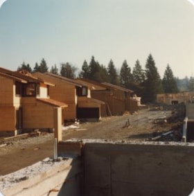
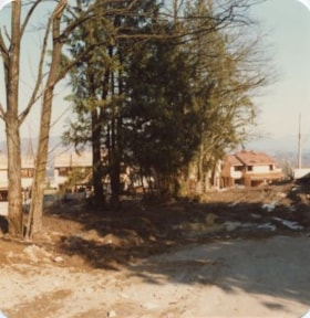
Construction of One Arbour Lane
https://search.heritageburnaby.ca/link/archivedescription36526
- Repository
- City of Burnaby Archives
- Date
- November 1978
- Collection/Fonds
- Burnaby Historical Society fonds
- Description Level
- Item
- Physical Description
- 1 photograph : col. ; 9 x 8.5 cm
- Scope and Content
- Photograph of the construction of the "new" townhouses at One Arbour Lane, taken looking south towards the trees on Burris Street.
- Repository
- City of Burnaby Archives
- Date
- November 1978
- Collection/Fonds
- Burnaby Historical Society fonds
- Subseries
- Lubbock family subseries
- Physical Description
- 1 photograph : col. ; 9 x 8.5 cm
- Description Level
- Item
- Record No.
- 289-015
- Access Restriction
- No restrictions
- Reproduction Restriction
- Reproduce for fair dealing purposes only
- Accession Number
- BHS1992-24
- Scope and Content
- Photograph of the construction of the "new" townhouses at One Arbour Lane, taken looking south towards the trees on Burris Street.
- Media Type
- Photograph
- Notes
- Title based on contents of photograph
- Geographic Access
- Mayview Circle
- Historic Neighbourhood
- Burnaby Lake (Historic Neighbourhood)
- Planning Study Area
- Morley-Buckingham Area
Images


Construction of One Arbour Lane
https://search.heritageburnaby.ca/link/archivedescription36528
- Repository
- City of Burnaby Archives
- Date
- November 1978
- Collection/Fonds
- Burnaby Historical Society fonds
- Description Level
- Item
- Physical Description
- 1 photograph : col. ; 9 x 8.5 cm
- Scope and Content
- Photograph of the "new" townhouses under construction at One Arbour Lane, taken looking south towards the trees on Burris Street.
- Repository
- City of Burnaby Archives
- Date
- November 1978
- Collection/Fonds
- Burnaby Historical Society fonds
- Subseries
- Lubbock family subseries
- Physical Description
- 1 photograph : col. ; 9 x 8.5 cm
- Description Level
- Item
- Record No.
- 289-017
- Access Restriction
- No restrictions
- Reproduction Restriction
- Reproduce for fair dealing purposes only
- Accession Number
- BHS1992-24
- Scope and Content
- Photograph of the "new" townhouses under construction at One Arbour Lane, taken looking south towards the trees on Burris Street.
- Media Type
- Photograph
- Notes
- Title based on contents of photograph
- Geographic Access
- Mayview Circle
- Burris Street
- Historic Neighbourhood
- Burnaby Lake (Historic Neighbourhood)
- Planning Study Area
- Morley-Buckingham Area
Images

Lou Marcoux and Fred Iacobucci
https://search.heritageburnaby.ca/link/archivedescription56668
- Repository
- City of Burnaby Archives
- Date
- May 1977
- Collection/Fonds
- Columbian Newspaper collection
- Description Level
- Item
- Physical Description
- 1 photograph : b&w ; 13.5 x 14.5 cm
- Scope and Content
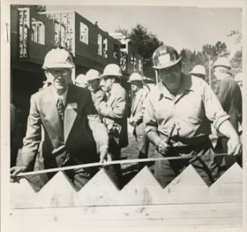
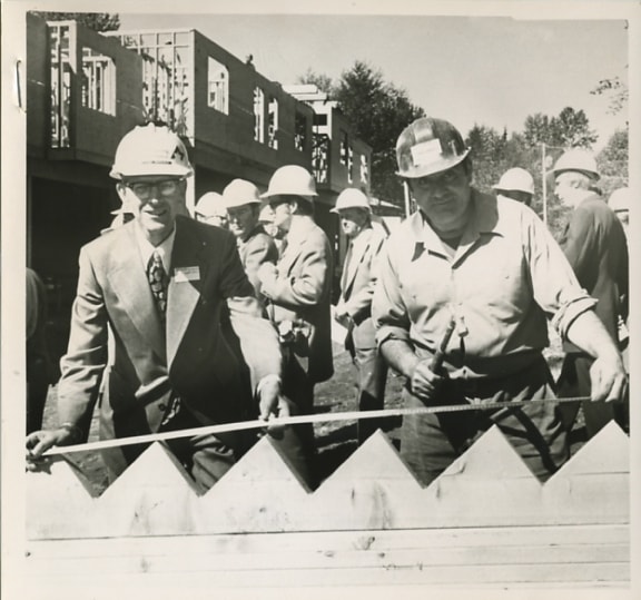
- Photograph of Lou Marcoux director of field operations for the ministry of housing, and "worker" Fred Iacobucci when they "got together to try to figure out the metric measurements" at the Forest Meadows open house. Forest Meadows is operated by Strata Council and has 134 suites.
- Repository
- City of Burnaby Archives
- Date
- May 1977
- Collection/Fonds
- Columbian Newspaper collection
- Physical Description
- 1 photograph : b&w ; 13.5 x 14.5 cm
- Description Level
- Item
- Record No.
- 480-1254
- Access Restriction
- No restrictions
- Reproduction Restriction
- No restrictions
- Accession Number
- 2003-02
- Scope and Content
- Photograph of Lou Marcoux director of field operations for the ministry of housing, and "worker" Fred Iacobucci when they "got together to try to figure out the metric measurements" at the Forest Meadows open house. Forest Meadows is operated by Strata Council and has 134 suites.
- Subjects
- Buildings - Residential - Townhouses
- Names
- Marcoux, Lou
- Iacobucci, Fred
- Media Type
- Photograph
- Photographer
- King, Basil
- Notes
- Title based on contents of photograph
- Newspaper clipping attached to verso of photograph reads: "Lou Marcoux, left, director of field operations for the ministry of housing, and worker Fred Iacobucci got together to try to figure out metric measurements Friday at the open house at Forest Meadows housing project in burnaby. The B.C. Housing Corporation is constructing the 134 condominiums on provincial land."
- Geographic Access
- Amberwood Place
- Rosswood Place
- Planning Study Area
- Lake City Area
Images

One Arbour Lane
https://search.heritageburnaby.ca/link/archivedescription36529
- Repository
- City of Burnaby Archives
- Date
- November 1978
- Collection/Fonds
- Burnaby Historical Society fonds
- Description Level
- Item
- Physical Description
- 1 photograph : col. ; 9 x 8.5 cm
- Scope and Content
- Photograph of the "new" townhouses under construction at One Arbour Lane, taken from Burris Street.
- Repository
- City of Burnaby Archives
- Date
- November 1978
- Collection/Fonds
- Burnaby Historical Society fonds
- Subseries
- Lubbock family subseries
- Physical Description
- 1 photograph : col. ; 9 x 8.5 cm
- Description Level
- Item
- Record No.
- 289-018
- Access Restriction
- No restrictions
- Reproduction Restriction
- Reproduce for fair dealing purposes only
- Accession Number
- BHS1992-24
- Scope and Content
- Photograph of the "new" townhouses under construction at One Arbour Lane, taken from Burris Street.
- Media Type
- Photograph
- Notes
- Title based on contents of photograph
- Geographic Access
- Burris Street
- Mayview Circle
- Historic Neighbourhood
- Burnaby Lake (Historic Neighbourhood)
- Planning Study Area
- Morley-Buckingham Area
Images
Previous site of farm house and stables
https://search.heritageburnaby.ca/link/archivedescription36527
- Repository
- City of Burnaby Archives
- Date
- November 1978
- Collection/Fonds
- Burnaby Historical Society fonds
- Description Level
- Item
- Physical Description
- 1 photograph : col. ; 9 x 8.5 cm
- Scope and Content
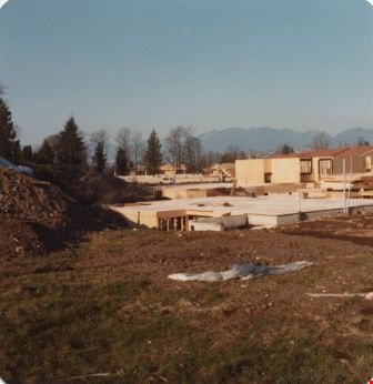
- Photograph taken looking towards the "new" townhouses under construction at One Arbour Lane. This is where the Lubbock farm house and stables used to be.
- Repository
- City of Burnaby Archives
- Date
- November 1978
- Collection/Fonds
- Burnaby Historical Society fonds
- Subseries
- Lubbock family subseries
- Physical Description
- 1 photograph : col. ; 9 x 8.5 cm
- Description Level
- Item
- Record No.
- 289-016
- Access Restriction
- No restrictions
- Reproduction Restriction
- Reproduce for fair dealing purposes only
- Accession Number
- BHS1992-24
- Scope and Content
- Photograph taken looking towards the "new" townhouses under construction at One Arbour Lane. This is where the Lubbock farm house and stables used to be.
- Media Type
- Photograph
- Notes
- Title based on contents of photograph
- Geographic Access
- Canada Way
- Mayview Circle
- Burris Street
- Grandview Highway
- Historic Neighbourhood
- Burnaby Lake (Historic Neighbourhood)
- Planning Study Area
- Morley-Buckingham Area
Images


Crossing Royal Oak & Rumble Street
https://search.heritageburnaby.ca/link/archivedescription93686
- Repository
- City of Burnaby Archives
- Date
- May 19, 1978
- Collection/Fonds
- Burnaby Public Library Contemporary Visual Archive Project
- Description Level
- Item
- Physical Description
- 1 photograph : b&w ; 12.5 x 17.5 cm
- Scope and Content
- Photograph of the intersection of Royal Oak Avenue and Rumble Street. Cars and pedestrians are crossing the intersection, and the signs for businesses TD Bank, Standard Oil/Chevron gas station, Gulf gas station, and Baxter's Market are visible. The photograph is taken from a corner of the intersect…
- Repository
- City of Burnaby Archives
- Date
- May 19, 1978
- Collection/Fonds
- Burnaby Public Library Contemporary Visual Archive Project
- Physical Description
- 1 photograph : b&w ; 12.5 x 17.5 cm
- Description Level
- Item
- Record No.
- 556-643
- Access Restriction
- No restrictions
- Reproduction Restriction
- Reproduce for fair dealing purposes only
- Accession Number
- 2017-57
- Scope and Content
- Photograph of the intersection of Royal Oak Avenue and Rumble Street. Cars and pedestrians are crossing the intersection, and the signs for businesses TD Bank, Standard Oil/Chevron gas station, Gulf gas station, and Baxter's Market are visible. The photograph is taken from a corner of the intersection, facing southeast.
- Subjects
- Geographic Features - Roads
- Advertising Medium - Signs and Signboards
- Buildings - Commercial - Service Stations
- Transportation - Automobiles
- Buildings - Commercial
- Media Type
- Photograph
- Photographer
- van Mannen, Mark
- Notes
- Title taken from project information form
- Accompanied by a project information form and 1 photograph (b&w negative ; 9.5 x 12.5 cm)
- BPL no. 91
- Geographic Access
- Royal Oak Avenue
- Rumble Street
- Historic Neighbourhood
- Alta Vista (Historic Neighbourhood)
- Planning Study Area
- Sussex-Nelson Area
Images


Crossing Royal Oak & Rumble Street
https://search.heritageburnaby.ca/link/archivedescription93687
- Repository
- City of Burnaby Archives
- Date
- May 19, 1978
- Collection/Fonds
- Burnaby Public Library Contemporary Visual Archive Project
- Description Level
- Item
- Physical Description
- 1 photograph : b&w ; 12.5 x 17.5 cm
- Scope and Content
- Photograph of the intersection of Royal Oak Avenue and Rumble Street. Cars and pedestrians are crossing the intersection, and the signs for businesses Grace United Pharmacy, Standard Oil/Chevron gas station, Gulf gas station, and Royal Meats are visible. The photograph is taken from the Gulf gas st…
- Repository
- City of Burnaby Archives
- Date
- May 19, 1978
- Collection/Fonds
- Burnaby Public Library Contemporary Visual Archive Project
- Physical Description
- 1 photograph : b&w ; 12.5 x 17.5 cm
- Description Level
- Item
- Record No.
- 556-644
- Access Restriction
- No restrictions
- Reproduction Restriction
- Reproduce for fair dealing purposes only
- Accession Number
- 2017-57
- Scope and Content
- Photograph of the intersection of Royal Oak Avenue and Rumble Street. Cars and pedestrians are crossing the intersection, and the signs for businesses Grace United Pharmacy, Standard Oil/Chevron gas station, Gulf gas station, and Royal Meats are visible. The photograph is taken from the Gulf gas station parking lot, facing northwest.
- Subjects
- Advertising Medium - Signs and Signboards
- Geographic Features - Roads
- Transportation - Automobiles
- Buildings - Commercial
- Buildings - Commercial - Service Stations
- Media Type
- Photograph
- Photographer
- van Mannen, Mark
- Notes
- Title taken from project information form
- Accompanied by a project information form and 1 photograph (b&w negative ; 9.5 x 12.5 cm)
- BPL no. 92
- Geographic Access
- Royal Oak Avenue
- Rumble Street
- Historic Neighbourhood
- Alta Vista (Historic Neighbourhood)
- Planning Study Area
- Sussex-Nelson Area
Images


Byrne Creek
https://search.heritageburnaby.ca/link/archivedescription36107
- Repository
- City of Burnaby Archives
- Date
- February 7, 1979
- Collection/Fonds
- Burnaby Historical Society fonds
- Description Level
- Item
- Physical Description
- 1 photograph : b&w ; 15 x 19.5 cm
- Scope and Content
- Photograph of Byrne Creek at a road's edge.
- Repository
- City of Burnaby Archives
- Date
- February 7, 1979
- Collection/Fonds
- Burnaby Historical Society fonds
- Subseries
- Columbian Newspaper subseries
- Physical Description
- 1 photograph : b&w ; 15 x 19.5 cm
- Description Level
- Item
- Record No.
- 222-030
- Access Restriction
- No restrictions
- Reproduction Restriction
- Reproduce for fair dealing purposes only
- Accession Number
- BHS1989-19
- Scope and Content
- Photograph of Byrne Creek at a road's edge.
- Media Type
- Photograph
- Photographer
- King, Basil
- Notes
- Title based on contents of photograph
- Newspaper clipping glued to verso of photograph reads: "Byrne Creek...fish habitat and a problem for developers."
- Geographic Access
- Byrne Creek
- Historic Neighbourhood
- Fraser Arm (Historic Neighbourhood)
- Planning Study Area
- Big Bend Area
Images

![3900 Albert Street, [between 1965 and 1970] thumbnail](/media/hpo/_Data/_Archives_Images/_Unrestricted/316/366-018.jpg?width=280)
3900 Albert Street
https://search.heritageburnaby.ca/link/archivedescription37389
- Repository
- City of Burnaby Archives
- Date
- [between 1965 and 1970]
- Collection/Fonds
- Burnaby Historical Society fonds
- Description Level
- Item
- Physical Description
- 1 photograph : b&w negative
- Scope and Content
- Photograph of the north side of 3900 Albert Street, looking west. The Vancouver Heights Baptist Church can be seen to the far right (at the corner of Albert Street and Ingleton Avenue).
- Repository
- City of Burnaby Archives
- Date
- [between 1965 and 1970]
- Collection/Fonds
- Burnaby Historical Society fonds
- Subseries
- Municipal record subseries
- Physical Description
- 1 photograph : b&w negative
- Description Level
- Item
- Record No.
- 366-018
- Access Restriction
- No restrictions
- Reproduction Restriction
- Reproduce for fair dealing purposes only
- Accession Number
- BHS1998-12
- Scope and Content
- Photograph of the north side of 3900 Albert Street, looking west. The Vancouver Heights Baptist Church can be seen to the far right (at the corner of Albert Street and Ingleton Avenue).
- Media Type
- Photograph
- Notes
- Title based on contents of photograph
- Geographic Access
- Ingleton Avenue
- Albert Street
- Street Address
- 3900 Albert Street
- 271 Ingleton Avenue
- 3977 Albert Street
- Historic Neighbourhood
- Vancouver Heights (Historic Neighbourhood)
- Planning Study Area
- Burnaby Heights Area
Images
![3900 Albert Street, [between 1965 and 1970] thumbnail](/media/hpo/_Data/_Archives_Images/_Unrestricted/316/366-018.jpg)
![3900 Albert Street at Ingleton Avenue, [between 1965 and 1970] thumbnail](/media/hpo/_Data/_Archives_Images/_Unrestricted/316/366-019.jpg?width=280)
3900 Albert Street at Ingleton Avenue
https://search.heritageburnaby.ca/link/archivedescription37390
- Repository
- City of Burnaby Archives
- Date
- [between 1965 and 1970]
- Collection/Fonds
- Burnaby Historical Society fonds
- Description Level
- Item
- Physical Description
- 1 photograph : b&w negative
- Scope and Content
- Photograph looking west along the north side of Albert Street from the 3900 Block. At the far right can be seen the Vancouver Heights Baptist Church, at the intersection of Albert and Ingleton Avenue.
- Repository
- City of Burnaby Archives
- Date
- [between 1965 and 1970]
- Collection/Fonds
- Burnaby Historical Society fonds
- Subseries
- Municipal record subseries
- Physical Description
- 1 photograph : b&w negative
- Description Level
- Item
- Record No.
- 366-019
- Access Restriction
- No restrictions
- Reproduction Restriction
- Reproduce for fair dealing purposes only
- Accession Number
- BHS1998-12
- Scope and Content
- Photograph looking west along the north side of Albert Street from the 3900 Block. At the far right can be seen the Vancouver Heights Baptist Church, at the intersection of Albert and Ingleton Avenue.
- Media Type
- Photograph
- Notes
- Title based on contents of photograph.
- Geographic Access
- Albert Street
- Ingleton Avenue
- Street Address
- 3900 Albert Street
- 271 Ingleton Avenue
- Historic Neighbourhood
- Vancouver Heights (Historic Neighbourhood)
- Planning Study Area
- Burnaby Heights Area
Images
![3900 Albert Street at Ingleton Avenue, [between 1965 and 1970] thumbnail](/media/hpo/_Data/_Archives_Images/_Unrestricted/316/366-019.jpg)
![3900 Hastings Street, [between 1965 and 1970] thumbnail](/media/hpo/_Data/_Archives_Images/_Unrestricted/316/366-010.jpg?width=280)
3900 Hastings Street
https://search.heritageburnaby.ca/link/archivedescription37381
- Repository
- City of Burnaby Archives
- Date
- [between 1965 and 1970]
- Collection/Fonds
- Burnaby Historical Society fonds
- Description Level
- Item
- Physical Description
- 1 photograph : b&w negative
- Scope and Content
- Photograph taken looking west along Hastings Street, in front of the 3900 Block.
- Repository
- City of Burnaby Archives
- Date
- [between 1965 and 1970]
- Collection/Fonds
- Burnaby Historical Society fonds
- Subseries
- Municipal record subseries
- Physical Description
- 1 photograph : b&w negative
- Description Level
- Item
- Record No.
- 366-010
- Access Restriction
- No restrictions
- Reproduction Restriction
- Reproduce for fair dealing purposes only
- Accession Number
- BHS1998-12
- Scope and Content
- Photograph taken looking west along Hastings Street, in front of the 3900 Block.
- Media Type
- Photograph
- Notes
- Title based on contents of photograph
- Geographic Access
- Hastings Street
- Historic Neighbourhood
- Vancouver Heights (Historic Neighbourhood)
- Planning Study Area
- Burnaby Heights Area
Images
![3900 Hastings Street, [between 1965 and 1970] thumbnail](/media/hpo/_Data/_Archives_Images/_Unrestricted/316/366-010.jpg)

Highrises on Kingsway
https://search.heritageburnaby.ca/link/archivedescription93692
- Repository
- City of Burnaby Archives
- Date
- June 4, 1978
- Collection/Fonds
- Burnaby Public Library Contemporary Visual Archive Project
- Description Level
- Item
- Physical Description
- 1 photograph : b&w ; 12.5 x 17.5 cm
- Scope and Content
- Photograph of high-rises apartment buildings and the neighbourhood along Kingsway by Central Park. The photograph is taken from a high point, facing east down Kingsway. The Central Park Veterinary Hospital, Central Park Place, a railway crossing, a gas station, and the Central Park Gate are visible…
- Repository
- City of Burnaby Archives
- Date
- June 4, 1978
- Collection/Fonds
- Burnaby Public Library Contemporary Visual Archive Project
- Physical Description
- 1 photograph : b&w ; 12.5 x 17.5 cm
- Description Level
- Item
- Record No.
- 556-649
- Access Restriction
- No restrictions
- Reproduction Restriction
- Reproduce for fair dealing purposes only
- Accession Number
- 2017-57
- Scope and Content
- Photograph of high-rises apartment buildings and the neighbourhood along Kingsway by Central Park. The photograph is taken from a high point, facing east down Kingsway. The Central Park Veterinary Hospital, Central Park Place, a railway crossing, a gas station, and the Central Park Gate are visible in the photograph.
- Subjects
- Buildings - Commercial
- Buildings - Residential - Apartments
- Buildings - Commercial - Service Stations
- Geographic Features - Parks
- Monuments
- Media Type
- Photograph
- Photographer
- Chapman, Fred
- Notes
- Title taken from project information form
- Accompanied by a project information form and 1 photograph (b&w negative ; 9.5 x 12.5 cm)
- BPL no. 97
- Geographic Access
- Kingsway
- Central Park
- Historic Neighbourhood
- Central Park (Historic Neighbourhood)
- Planning Study Area
- Maywood Area
Images
