More like '4350 Grange St'
Narrow Results By
Subject
- Accidents 7
- Accidents - Automobile Accidents 11
- Accidents - Train Accidents 9
- Adornment 1
- Adornment - Lapel Pins 1
- Advertising Medium 16
- Advertising Medium - Signs and Signboards 61
- Aerial Photographs 24
- Agricultural Tools and Equipment 6
- Agricultural Tools and Equipment - Gardening Equipment 6
- Agricultural Tools and Equipment - Plows 9
- Agriculture 4
![Aftermath of a snowfall, [1999] thumbnail](/media/hpo/_Data/_Archives_Images/_Unrestricted/535/535-3125-1.jpg?width=280)
Aftermath of a snowfall
https://search.heritageburnaby.ca/link/archivedescription98045
- Repository
- City of Burnaby Archives
- Date
- [1999]
- Collection/Fonds
- Burnaby NewsLeader photograph collection
- Description Level
- File
- Physical Description
- 4 photographs (tiff) : b&w
- Scope and Content
- File contains photographs of the aftermath of a large snowfall. Photographs depict an unidentified person moving snow with a wheelbarrow; people shovelling out cars stuck on roads in the snow; and a crane and snow-covered park.
- Repository
- City of Burnaby Archives
- Date
- [1999]
- Collection/Fonds
- Burnaby NewsLeader photograph collection
- Physical Description
- 4 photographs (tiff) : b&w
- Description Level
- File
- Record No.
- 535-3125
- Access Restriction
- No restrictions
- Reproduction Restriction
- No restrictions
- Accession Number
- 2018-12
- Scope and Content
- File contains photographs of the aftermath of a large snowfall. Photographs depict an unidentified person moving snow with a wheelbarrow; people shovelling out cars stuck on roads in the snow; and a crane and snow-covered park.
- Subjects
- Natural Phenomena - Snow
- Geographic Features - Parks
- Geographic Features - Roads
- Transportation - Automobiles
- Media Type
- Photograph
- Notes
- Title based on contents of file
- Collected by editorial for use in a February 1999 issue of the Burnaby NewsLeader
Images
![Aftermath of a snowfall, [1999] thumbnail](/media/hpo/_Data/_Archives_Images/_Unrestricted/535/535-3125-1.jpg)
![Rail crossing at Government and Cariboo, [2006] thumbnail](/media/hpo/_Data/_Archives_Images/_Unrestricted/535/535-1880.jpg?width=280)
Rail crossing at Government and Cariboo
https://search.heritageburnaby.ca/link/archivedescription96183
- Repository
- City of Burnaby Archives
- Date
- [2006]
- Collection/Fonds
- Burnaby NewsLeader photograph collection
- Description Level
- Item
- Physical Description
- 1 photograph (tiff) : b&w
- Scope and Content
- Photograph of the rail crossing at the intersection of Government Street and Cariboo Road. Two cars are passing on the road and the opposite directions of traffic are separated by a barrier on the road.
- Repository
- City of Burnaby Archives
- Date
- [2006]
- Collection/Fonds
- Burnaby NewsLeader photograph collection
- Physical Description
- 1 photograph (tiff) : b&w
- Description Level
- Item
- Record No.
- 535-1880
- Access Restriction
- No restrictions
- Reproduction Restriction
- No restrictions
- Accession Number
- 2018-12
- Scope and Content
- Photograph of the rail crossing at the intersection of Government Street and Cariboo Road. Two cars are passing on the road and the opposite directions of traffic are separated by a barrier on the road.
- Media Type
- Photograph
- Photographer
- Bartel, Mario
- Notes
- Title based on caption
- Collected by editorial for use in a January 2006 issue of the Burnaby NewsLeader
- Caption from metadata: "An accident involving a car and a train last summer has prompted the installation of barriers at the rail crossing at Government and Cariboo to prevent cars from jumping the line to beat the crossing arms."
- Geographic Access
- Government Street
- Cariboo Road
- Planning Study Area
- Burnaby Lake Area
Images
![Rail crossing at Government and Cariboo, [2006] thumbnail](/media/hpo/_Data/_Archives_Images/_Unrestricted/535/535-1880.jpg)

Venables Street
https://search.heritageburnaby.ca/link/archivedescription52845
- Repository
- City of Burnaby Archives
- Date
- 1981
- Collection/Fonds
- Harold H. Johnston fonds
- Description Level
- Item
- Physical Description
- 1 photograph (jpeg) : b&w
- Scope and Content
- Photograph of a woman standing next to two children on a tricycle on Venables Street. A man is on the far right standing next to a parked car. Three of the people in the photograph are identified by first name only as Sharron, Andrea and Frank. The photograph was most likely taken near the Johnston…
- Repository
- City of Burnaby Archives
- Date
- 1981
- Collection/Fonds
- Harold H. Johnston fonds
- Physical Description
- 1 photograph (jpeg) : b&w
- Description Level
- Item
- Record No.
- 483-102
- Access Restriction
- No restrictions
- Reproduction Restriction
- No reproduction permitted
- Accession Number
- 2008-08
- Scope and Content
- Photograph of a woman standing next to two children on a tricycle on Venables Street. A man is on the far right standing next to a parked car. Three of the people in the photograph are identified by first name only as Sharron, Andrea and Frank. The photograph was most likely taken near the Johnston family home at 4447 Venables Street.
- Subjects
- Transportation - Automobiles
- Transportation - Bicycles
- Buildings - Residential - Houses
- Geographic Features - Roads
- Media Type
- Photograph
- Photographer
- Johnston, Harold H.
- Notes
- Title based on contents of photograph
- Geographic Access
- Venables Street
- Historic Neighbourhood
- Vancouver Heights (Historic Neighbourhood)
- Planning Study Area
- Willingdon Heights Area
Images

![1935 Ford in the Snow, [193-?] (date of original), copied 1992 thumbnail](/media/hpo/_Data/_Archives_Images/_Unrestricted/315/315-373.jpg?width=280)
1935 Ford in the Snow
https://search.heritageburnaby.ca/link/archivedescription36915
- Repository
- City of Burnaby Archives
- Date
- [193-?] (date of original), copied 1992
- Collection/Fonds
- Burnaby Historical Society fonds
- Description Level
- Item
- Physical Description
- 1 photograph : b&w ; 8.8 x 12.7 cm print
- Scope and Content
- Photograph of a 1935 Ford beside a snow bank.
- Repository
- City of Burnaby Archives
- Date
- [193-?] (date of original), copied 1992
- Collection/Fonds
- Burnaby Historical Society fonds
- Subseries
- Burnaby Centennial Anthology subseries
- Physical Description
- 1 photograph : b&w ; 8.8 x 12.7 cm print
- Description Level
- Item
- Record No.
- 315-373
- Access Restriction
- No restrictions
- Reproduction Restriction
- No known restrictions
- Accession Number
- BHS1994-04
- Scope and Content
- Photograph of a 1935 Ford beside a snow bank.
- Media Type
- Photograph
- Notes
- Title based on contents of photograph
Images
![1935 Ford in the Snow, [193-?] (date of original), copied 1992 thumbnail](/media/hpo/_Data/_Archives_Images/_Unrestricted/315/315-373.jpg)

Automobile on Kinnee Street
https://search.heritageburnaby.ca/link/archivedescription35060
- Repository
- City of Burnaby Archives
- Date
- 1915
- Collection/Fonds
- Burnaby Historical Society fonds
- Description Level
- Item
- Physical Description
- 1 photograph : b&w ; 11.0 x 6.2 cm
- Scope and Content
- Photograph of an automobile on Kinnee Street with the Patterson Avenue pump house and tank in the background. An annotation on the back of the photograph reads, "Water tank at Patterson Ave near the track in the Central Park (Ball park), 1915. / The roadway was Kinnee Ave which is Beresford today."
- Repository
- City of Burnaby Archives
- Date
- 1915
- Collection/Fonds
- Burnaby Historical Society fonds
- Subseries
- Pitman family subseries
- Physical Description
- 1 photograph : b&w ; 11.0 x 6.2 cm
- Description Level
- Item
- Record No.
- 186-004
- Access Restriction
- No restrictions
- Reproduction Restriction
- No known restrictions
- Accession Number
- BHS1986-35
- Scope and Content
- Photograph of an automobile on Kinnee Street with the Patterson Avenue pump house and tank in the background. An annotation on the back of the photograph reads, "Water tank at Patterson Ave near the track in the Central Park (Ball park), 1915. / The roadway was Kinnee Ave which is Beresford today."
- Media Type
- Photograph
- Notes
- Title based on contents of photograph
- Geographic Access
- Beresford Street
- Historic Neighbourhood
- Central Park (Historic Neighbourhood)
- Planning Study Area
- Maywood Area
Images


Crossing Royal Oak & Rumble Street
https://search.heritageburnaby.ca/link/archivedescription93686
- Repository
- City of Burnaby Archives
- Date
- May 19, 1978
- Collection/Fonds
- Burnaby Public Library Contemporary Visual Archive Project
- Description Level
- Item
- Physical Description
- 1 photograph : b&w ; 12.5 x 17.5 cm
- Scope and Content
- Photograph of the intersection of Royal Oak Avenue and Rumble Street. Cars and pedestrians are crossing the intersection, and the signs for businesses TD Bank, Standard Oil/Chevron gas station, Gulf gas station, and Baxter's Market are visible. The photograph is taken from a corner of the intersect…
- Repository
- City of Burnaby Archives
- Date
- May 19, 1978
- Collection/Fonds
- Burnaby Public Library Contemporary Visual Archive Project
- Physical Description
- 1 photograph : b&w ; 12.5 x 17.5 cm
- Description Level
- Item
- Record No.
- 556-643
- Access Restriction
- No restrictions
- Reproduction Restriction
- Reproduce for fair dealing purposes only
- Accession Number
- 2017-57
- Scope and Content
- Photograph of the intersection of Royal Oak Avenue and Rumble Street. Cars and pedestrians are crossing the intersection, and the signs for businesses TD Bank, Standard Oil/Chevron gas station, Gulf gas station, and Baxter's Market are visible. The photograph is taken from a corner of the intersection, facing southeast.
- Subjects
- Geographic Features - Roads
- Advertising Medium - Signs and Signboards
- Buildings - Commercial - Service Stations
- Transportation - Automobiles
- Buildings - Commercial
- Media Type
- Photograph
- Photographer
- van Mannen, Mark
- Notes
- Title taken from project information form
- Accompanied by a project information form and 1 photograph (b&w negative ; 9.5 x 12.5 cm)
- BPL no. 91
- Geographic Access
- Royal Oak Avenue
- Rumble Street
- Historic Neighbourhood
- Alta Vista (Historic Neighbourhood)
- Planning Study Area
- Sussex-Nelson Area
Images


Crossing Royal Oak & Rumble Street
https://search.heritageburnaby.ca/link/archivedescription93687
- Repository
- City of Burnaby Archives
- Date
- May 19, 1978
- Collection/Fonds
- Burnaby Public Library Contemporary Visual Archive Project
- Description Level
- Item
- Physical Description
- 1 photograph : b&w ; 12.5 x 17.5 cm
- Scope and Content
- Photograph of the intersection of Royal Oak Avenue and Rumble Street. Cars and pedestrians are crossing the intersection, and the signs for businesses Grace United Pharmacy, Standard Oil/Chevron gas station, Gulf gas station, and Royal Meats are visible. The photograph is taken from the Gulf gas st…
- Repository
- City of Burnaby Archives
- Date
- May 19, 1978
- Collection/Fonds
- Burnaby Public Library Contemporary Visual Archive Project
- Physical Description
- 1 photograph : b&w ; 12.5 x 17.5 cm
- Description Level
- Item
- Record No.
- 556-644
- Access Restriction
- No restrictions
- Reproduction Restriction
- Reproduce for fair dealing purposes only
- Accession Number
- 2017-57
- Scope and Content
- Photograph of the intersection of Royal Oak Avenue and Rumble Street. Cars and pedestrians are crossing the intersection, and the signs for businesses Grace United Pharmacy, Standard Oil/Chevron gas station, Gulf gas station, and Royal Meats are visible. The photograph is taken from the Gulf gas station parking lot, facing northwest.
- Subjects
- Advertising Medium - Signs and Signboards
- Geographic Features - Roads
- Transportation - Automobiles
- Buildings - Commercial
- Buildings - Commercial - Service Stations
- Media Type
- Photograph
- Photographer
- van Mannen, Mark
- Notes
- Title taken from project information form
- Accompanied by a project information form and 1 photograph (b&w negative ; 9.5 x 12.5 cm)
- BPL no. 92
- Geographic Access
- Royal Oak Avenue
- Rumble Street
- Historic Neighbourhood
- Alta Vista (Historic Neighbourhood)
- Planning Study Area
- Sussex-Nelson Area
Images


Deer Crossing Sign on Road to SFU
https://search.heritageburnaby.ca/link/archivedescription93671
- Repository
- City of Burnaby Archives
- Date
- January 18, 1978
- Collection/Fonds
- Burnaby Public Library Contemporary Visual Archive Project
- Description Level
- Item
- Physical Description
- 1 photograph : b&w ; 12.5 x 17.5 cm
- Scope and Content
- Photograph of the road to Simon Fraser University on Burnaby Mountain, with a deer crossing sign on the right-hand side of the photograph and a car driving ahead. The photograph appears to be taken from a car parked on the shoulder of the road, facing east.
- Repository
- City of Burnaby Archives
- Date
- January 18, 1978
- Collection/Fonds
- Burnaby Public Library Contemporary Visual Archive Project
- Physical Description
- 1 photograph : b&w ; 12.5 x 17.5 cm
- Description Level
- Item
- Record No.
- 556-628
- Access Restriction
- No restrictions
- Reproduction Restriction
- Reproduce for fair dealing purposes only
- Accession Number
- 2017-57
- Scope and Content
- Photograph of the road to Simon Fraser University on Burnaby Mountain, with a deer crossing sign on the right-hand side of the photograph and a car driving ahead. The photograph appears to be taken from a car parked on the shoulder of the road, facing east.
- Names
- Simon Fraser University
- Media Type
- Photograph
- Photographer
- Surridge, Jack
- Notes
- Title taken from project information form
- Accompanied by a project information form and 1 photograph (b&w negative ; 9.5 x 12.5 cm)
- BPL no. 77
- Geographic Access
- University Drive
- Burnaby Mountain Conservation Area
- Planning Study Area
- Burnaby Mountain Area
Images


Frank Warburton
https://search.heritageburnaby.ca/link/archivedescription35915
- Repository
- City of Burnaby Archives
- Date
- 1928 (date of original), copied 1986
- Collection/Fonds
- Burnaby Historical Society fonds
- Description Level
- Item
- Physical Description
- 1 photograph : b&w ; 12.7 x 17.8 cm print
- Scope and Content
- Photograph of Frank Warburton painting white lines along Kingsway.
- Repository
- City of Burnaby Archives
- Date
- 1928 (date of original), copied 1986
- Collection/Fonds
- Burnaby Historical Society fonds
- Subseries
- Pioneer Tales subseries
- Physical Description
- 1 photograph : b&w ; 12.7 x 17.8 cm print
- Description Level
- Item
- Record No.
- 204-774
- Access Restriction
- No restrictions
- Reproduction Restriction
- No known restrictions
- Accession Number
- BHS1988-03
- Scope and Content
- Photograph of Frank Warburton painting white lines along Kingsway.
- Names
- Warburton, Frank
- Media Type
- Photograph
- Notes
- Title based on contents of photograph
- Geographic Access
- Kingsway
Images

![Gaglardi Way pedestrian overpass, [2005] thumbnail](/media/hpo/_Data/_Archives_Images/_Unrestricted/535/535-1858.jpg?width=280)
Gaglardi Way pedestrian overpass
https://search.heritageburnaby.ca/link/archivedescription96161
- Repository
- City of Burnaby Archives
- Date
- [2005]
- Collection/Fonds
- Burnaby NewsLeader photograph collection
- Description Level
- Item
- Physical Description
- 1 photograph (tiff) : col.
- Scope and Content
- Photograph of Alex Nemeth posing next to his truck and the pedestrian overpass on Gaglardi Way.
- Repository
- City of Burnaby Archives
- Date
- [2005]
- Collection/Fonds
- Burnaby NewsLeader photograph collection
- Physical Description
- 1 photograph (tiff) : col.
- Description Level
- Item
- Record No.
- 535-1858
- Access Restriction
- No restrictions
- Reproduction Restriction
- No restrictions
- Accession Number
- 2018-12
- Scope and Content
- Photograph of Alex Nemeth posing next to his truck and the pedestrian overpass on Gaglardi Way.
- Media Type
- Photograph
- Photographer
- Bartel, Mario
- Notes
- Title based on caption
- Collected by editorial for use in a January 2005 issue of the Burnaby NewsLeader
- Caption from metadata: "The windshield on Alex Nemeth's pickup truck was smashed on Tuesday when kids dropped snowballs filled with rocks from the pedestrian overpass on Gagliardi Way in Burnaby as he passed underneath on his way to work. The City of Burnaby has promised to enclose the walkway."
- Geographic Access
- Gaglardi Way
Images
![Gaglardi Way pedestrian overpass, [2005] thumbnail](/media/hpo/_Data/_Archives_Images/_Unrestricted/535/535-1858.jpg)

Kensington Overpass Area
https://search.heritageburnaby.ca/link/archivedescription93631
- Repository
- City of Burnaby Archives
- Date
- October 22, 1977
- Collection/Fonds
- Burnaby Public Library Contemporary Visual Archive Project
- Description Level
- Item
- Physical Description
- 1 photograph : b&w ; 12.5 x 17.5 cm
- Scope and Content
- Photograph of the Kensington Overpass area by Lougheed Highway and Sperling Avenue. The overpass was not yet constructed at the time of this photograph but was under discussion by the City of Burnaby Council. The photograph is taken from the side of the road, facing south.
- Repository
- City of Burnaby Archives
- Date
- October 22, 1977
- Collection/Fonds
- Burnaby Public Library Contemporary Visual Archive Project
- Physical Description
- 1 photograph : b&w ; 12.5 x 17.5 cm
- Description Level
- Item
- Record No.
- 556-588
- Access Restriction
- No restrictions
- Reproduction Restriction
- Reproduce for fair dealing purposes only
- Accession Number
- 2017-57
- Scope and Content
- Photograph of the Kensington Overpass area by Lougheed Highway and Sperling Avenue. The overpass was not yet constructed at the time of this photograph but was under discussion by the City of Burnaby Council. The photograph is taken from the side of the road, facing south.
- Media Type
- Photograph
- Photographer
- Surridge, Jack
- Notes
- Title taken from project information form
- Accompanied by a project information form and 1 photograph (b&w negative ; 9.5 x 12.5 cm)
- BPL no. 37
- Geographic Access
- Kensington Avenue
- Sperling Avenue
- Lougheed Highway
- Planning Study Area
- Sperling-Broadway Area
Images


Kingsway
https://search.heritageburnaby.ca/link/archivedescription34511
- Repository
- City of Burnaby Archives
- Date
- 1920
- Collection/Fonds
- Burnaby Historical Society fonds
- Description Level
- Item
- Physical Description
- 1 photograph : sepia ; 12.6 x 17.6 cm
- Scope and Content
- Photograph of Kingsway looking east at Boundary Road. A sign on the right reads, "Burnaby / Vehicles must slow down at all schools and intersections marked thus: X." A sign on a building at the left reads, "Arctic Ice Cream." Central Park is on the right.
- Repository
- City of Burnaby Archives
- Date
- 1920
- Collection/Fonds
- Burnaby Historical Society fonds
- Subseries
- Photographs subseries
- Physical Description
- 1 photograph : sepia ; 12.6 x 17.6 cm
- Description Level
- Item
- Record No.
- 031-002
- Access Restriction
- No restrictions
- Reproduction Restriction
- No known restrictions
- Accession Number
- BHS2007-04
- Scope and Content
- Photograph of Kingsway looking east at Boundary Road. A sign on the right reads, "Burnaby / Vehicles must slow down at all schools and intersections marked thus: X." A sign on a building at the left reads, "Arctic Ice Cream." Central Park is on the right.
- Subjects
- Geographic Features - Roads
- Advertising Medium - Signs and Signboards
- Transportation - Automobiles
- Media Type
- Photograph
- Notes
- Title based on contents of photograph
- Geographic Access
- Kingsway
- Central Park
- Boundary Road
- Historic Neighbourhood
- Central Park (Historic Neighbourhood)
- Planning Study Area
- Garden Village Area
- Maywood Area
Images

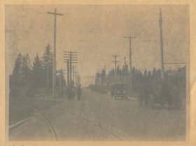
Opening of Kingsway
https://search.heritageburnaby.ca/link/archivedescription34031
- Repository
- City of Burnaby Archives
- Date
- September 30, 1913
- Collection/Fonds
- Burnaby Historical Society fonds
- Description Level
- Item
- Physical Description
- 1 photograph : b&w negative ; 8 x 11 cm
- Scope and Content
- Photograph of the official opening of Kingsway taken at Edmonds Street looking east. Automobiles and Interturban tracks are visible.
- Repository
- City of Burnaby Archives
- Date
- September 30, 1913
- Collection/Fonds
- Burnaby Historical Society fonds
- Subseries
- Stride family subseries
- Physical Description
- 1 photograph : b&w negative ; 8 x 11 cm
- Description Level
- Item
- Record No.
- 001-007
- Access Restriction
- No restrictions
- Reproduction Restriction
- No known restrictions
- Accession Number
- BHS2007-04
- Scope and Content
- Photograph of the official opening of Kingsway taken at Edmonds Street looking east. Automobiles and Interturban tracks are visible.
- Media Type
- Photograph
- Notes
- Title based on contents of photograph
- Geographic Access
- Kingsway
- Edmonds Street
- Historic Neighbourhood
- Edmonds (Historic Neighbourhood)
- Planning Study Area
- Edmonds Area
- Stride Avenue Area
Images
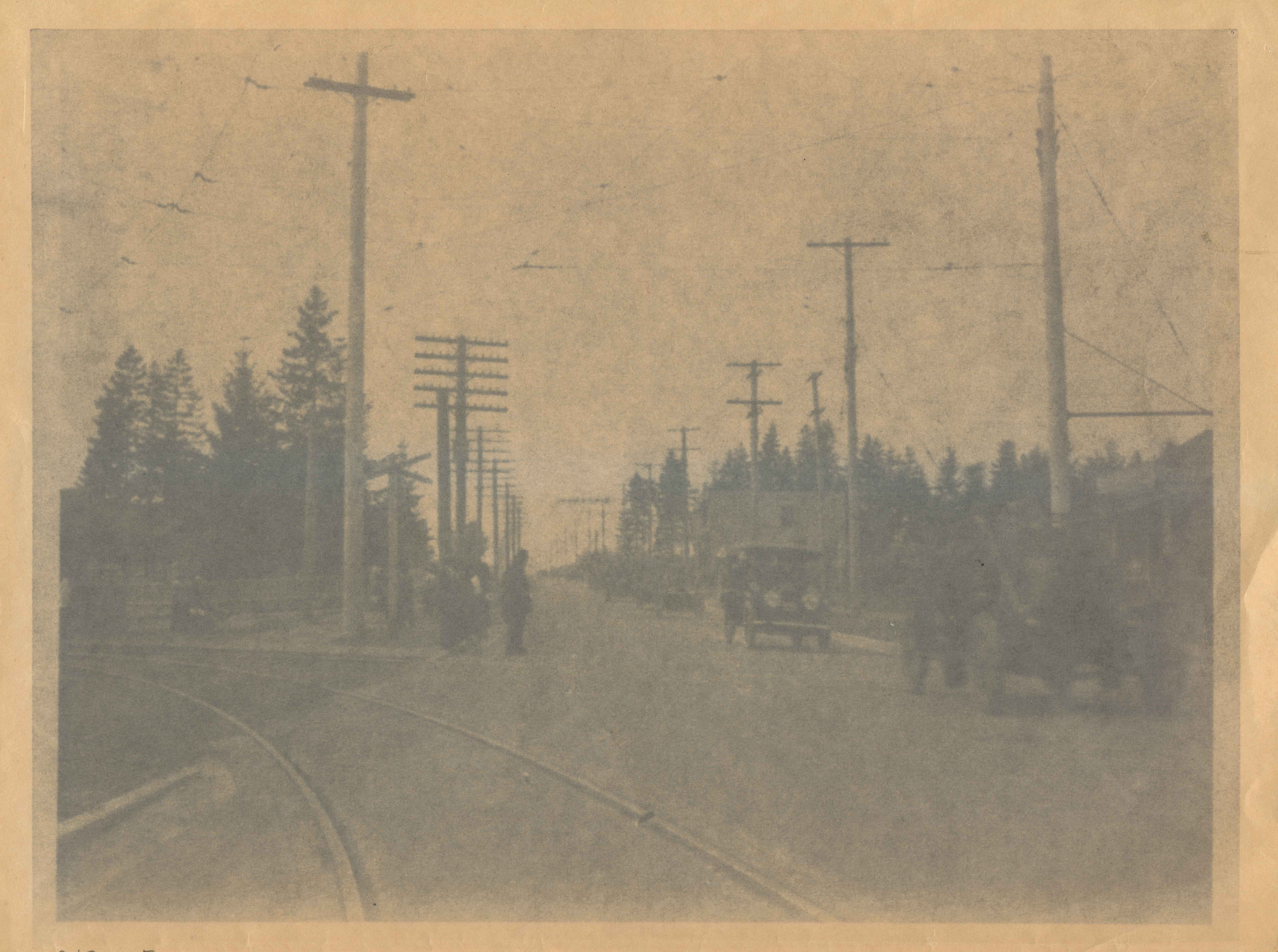

Opening of Kingsway
https://search.heritageburnaby.ca/link/archivedescription37142
- Repository
- City of Burnaby Archives
- Date
- September 30, 1913
- Collection/Fonds
- Burnaby Historical Society fonds
- Description Level
- Item
- Physical Description
- 1 photograph : b&w ; 8 x 12.5 cm print
- Scope and Content
- Photograph of the parade held to mark the opening of Kingsway, taken on Kingsway at Edmonds. A long line of touring cars are forming the parade.
- Repository
- City of Burnaby Archives
- Date
- September 30, 1913
- Collection/Fonds
- Burnaby Historical Society fonds
- Subseries
- Disney family subseries
- Physical Description
- 1 photograph : b&w ; 8 x 12.5 cm print
- Description Level
- Item
- Record No.
- 325-014
- Access Restriction
- No restrictions
- Reproduction Restriction
- Reproduce for fair dealing purposes only
- Accession Number
- BHS1996-04
- Scope and Content
- Photograph of the parade held to mark the opening of Kingsway, taken on Kingsway at Edmonds. A long line of touring cars are forming the parade.
- Media Type
- Photograph
- Photographer
- Disney, John Harold "Jack"
- Notes
- Title based on contents of photograph
- Geographic Access
- Kingsway
- Edmonds Street
- Historic Neighbourhood
- Edmonds (Historic Neighbourhood)
- Planning Study Area
- Edmonds Area
Images

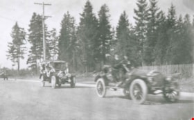
Opening of Kingsway
https://search.heritageburnaby.ca/link/archivedescription37143
- Repository
- City of Burnaby Archives
- Date
- September 30, 1913
- Collection/Fonds
- Burnaby Historical Society fonds
- Description Level
- Item
- Physical Description
- 1 photograph : b&w ; 8.5 x 12.5 cm print
- Scope and Content
- Photograph of the parade held to mark the opening of Kingsway, taken on Kingsway at Edmonds. Touring cars are forming the parade.
- Repository
- City of Burnaby Archives
- Date
- September 30, 1913
- Collection/Fonds
- Burnaby Historical Society fonds
- Subseries
- Disney family subseries
- Physical Description
- 1 photograph : b&w ; 8.5 x 12.5 cm print
- Description Level
- Item
- Record No.
- 325-015
- Access Restriction
- No restrictions
- Reproduction Restriction
- Reproduce for fair dealing purposes only
- Accession Number
- BHS1996-04
- Scope and Content
- Photograph of the parade held to mark the opening of Kingsway, taken on Kingsway at Edmonds. Touring cars are forming the parade.
- Media Type
- Photograph
- Photographer
- Disney, John Harold "Jack"
- Notes
- Title based on contents of photograph
- Geographic Access
- Kingsway
- Edmonds Street
- Historic Neighbourhood
- Edmonds (Historic Neighbourhood)
- Planning Study Area
- Edmonds Area
Images
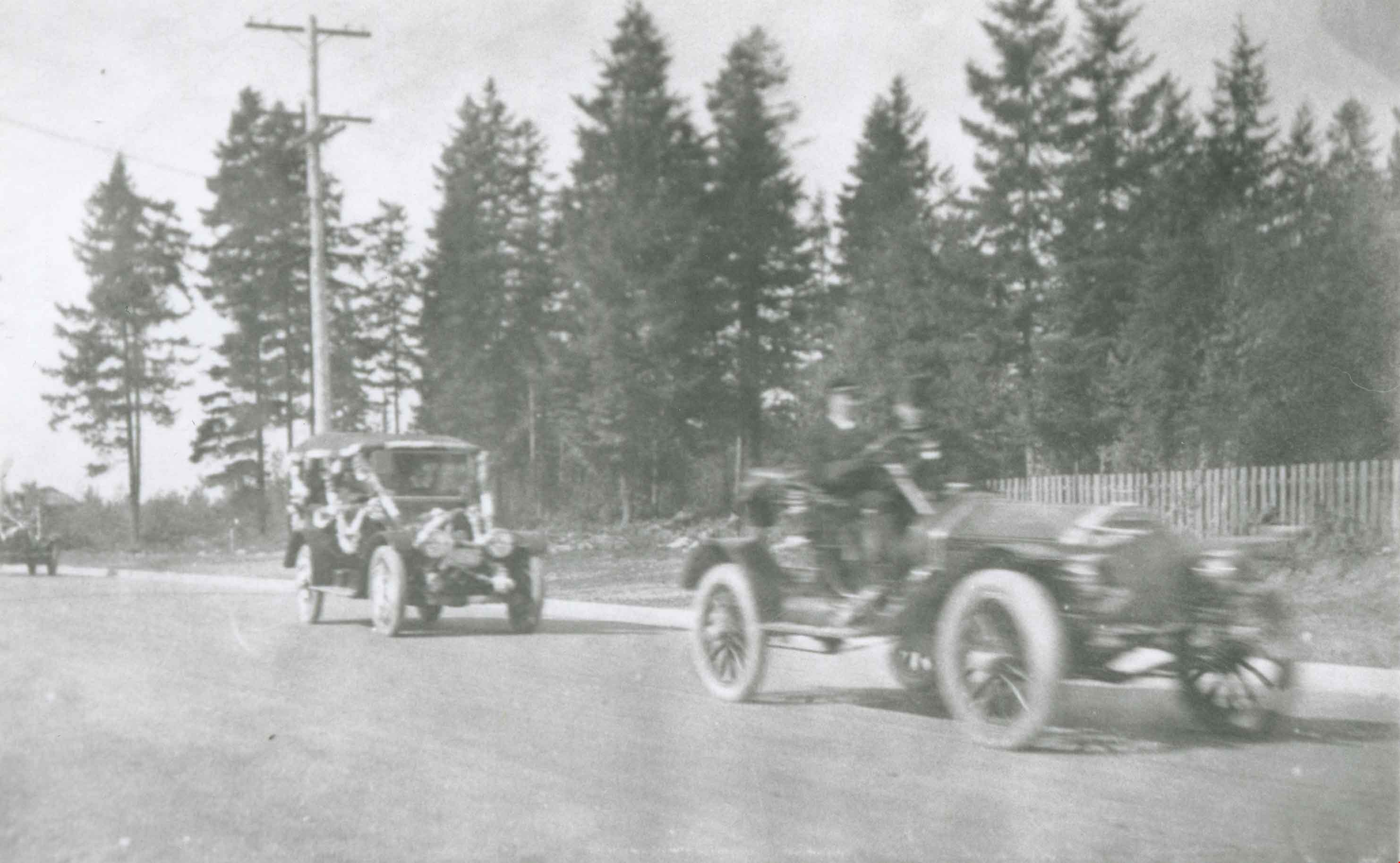

Painting Centre Line on Kingsway
https://search.heritageburnaby.ca/link/museumdescription65
- Repository
- Burnaby Village Museum
- Date
- 1928 (date of original), copied 1971
- Collection/Fonds
- Burnaby Village Museum Photograph collection
- Description Level
- Item
- Physical Description
- 1 photograph : b&w ; 15.0 x 25.2 cm print
- Scope and Content
- Photograph of Frank Warburton sitting backwards on a plank attached to the front of a car, as it is being driven. The make of the car is unidentified, but has wooden spoked wheels, running boards, and a soft convertible top. Mr. Warburton is painting the centre line on Kingsway. The photograph is…
- Repository
- Burnaby Village Museum
- Collection/Fonds
- Burnaby Village Museum Photograph collection
- Description Level
- Item
- Physical Description
- 1 photograph : b&w ; 15.0 x 25.2 cm print
- Scope and Content
- Photograph of Frank Warburton sitting backwards on a plank attached to the front of a car, as it is being driven. The make of the car is unidentified, but has wooden spoked wheels, running boards, and a soft convertible top. Mr. Warburton is painting the centre line on Kingsway. The photograph is taken 1928 at corner of Grimmer and Kingsway. In the background of the photograph, to the left, there are residential houses with a parked car, and to the right, is a tall gas pump.
- Names
- Warburton, Frank
- Geographic Access
- Kingsway
- Grimmer Street
- Accession Code
- HV971.173.1
- Access Restriction
- No restrictions
- Reproduction Restriction
- No known restrictions
- Date
- 1928 (date of original), copied 1971
- Media Type
- Photograph
- Historic Neighbourhood
- Central Park (Historic Neighbourhood)
- Planning Study Area
- Windsor Area
- Scan Resolution
- 600
- Scan Date
- 2023-03-28
- Notes
- Title based on contents of photograph
- The information in scope and content taken from earlier catalgue record from 1976, and verified by various accession and donation paperworks
Images


Sperling Avenue and Barnet Road
https://search.heritageburnaby.ca/link/archivedescription35442
- Repository
- City of Burnaby Archives
- Date
- 1915 (date of original), copied 1986
- Collection/Fonds
- Burnaby Historical Society fonds
- Description Level
- Item
- Physical Description
- 1 photograph : b&w ; 12.7 x 17.8 cm print
- Scope and Content
- Photograph of a Cadillac full of passengers driving along the plank roadway at Sperling Avenue and Barnet Road.
- Repository
- City of Burnaby Archives
- Date
- 1915 (date of original), copied 1986
- Collection/Fonds
- Burnaby Historical Society fonds
- Subseries
- Pioneer Tales subseries
- Physical Description
- 1 photograph : b&w ; 12.7 x 17.8 cm print
- Description Level
- Item
- Record No.
- 204-300
- Access Restriction
- No restrictions
- Reproduction Restriction
- No restrictions
- Accession Number
- BHS1988-03
- Scope and Content
- Photograph of a Cadillac full of passengers driving along the plank roadway at Sperling Avenue and Barnet Road.
- Media Type
- Photograph
- Photographer
- Eaton, Dr. Carl
- Notes
- Title based on contents of photograph
- Photograph is believed to be taken by Dr. Carl Eaton
- Geographic Access
- Sperling Avenue
- Barnet Road
- Historic Neighbourhood
- Lochdale (Historic Neighbourhood)
- Planning Study Area
- Westridge Area
Images

![Willingdon on-ramp flooding, [2005] thumbnail](/media/hpo/_Data/_Archives_Images/_Unrestricted/535/535-1860-1.jpg?width=280)
Willingdon on-ramp flooding
https://search.heritageburnaby.ca/link/archivedescription96163
- Repository
- City of Burnaby Archives
- Date
- [2005]
- Collection/Fonds
- Burnaby NewsLeader photograph collection
- Description Level
- File
- Physical Description
- 2 photographs (tiff) : col.
- Scope and Content
- File contains photographs of flooding at the Willingdon on-ramp to Highway 1 in Burnaby after a significant rainstorm. Photographs depict a worker placing pylons to close the on-ramp and cars attempting to drive through deep puddles by the highway.
- Repository
- City of Burnaby Archives
- Date
- [2005]
- Collection/Fonds
- Burnaby NewsLeader photograph collection
- Physical Description
- 2 photographs (tiff) : col.
- Description Level
- File
- Record No.
- 535-1860
- Access Restriction
- No restrictions
- Reproduction Restriction
- No restrictions
- Accession Number
- 2018-12
- Scope and Content
- File contains photographs of flooding at the Willingdon on-ramp to Highway 1 in Burnaby after a significant rainstorm. Photographs depict a worker placing pylons to close the on-ramp and cars attempting to drive through deep puddles by the highway.
- Media Type
- Photograph
- Photographer
- Bartel, Mario
- Notes
- Title based on caption
- Collected by editorial for use in a January 2005 issue of the Burnaby NewsLeader
- Caption from metadata for 535-1860-1: "A worker for Mainroad Contracting closes the Willingdon on-ramp to Highway 1 because of flooding during Monday's torrential rainstorm."
- Caption from metadata for 535-1860-2: "After two weeks of snow and cold temperatures, Lower Mainland drivers find themselves in familiar territory, plowing through deep puddles on Willingdon, just north of Highway 1."
- Geographic Access
- Willingdon Avenue
- Planning Study Area
- West Central Valley Area
Images
![Willingdon on-ramp flooding, [2005] thumbnail](/media/hpo/_Data/_Archives_Images/_Unrestricted/535/535-1860-1.jpg)
![Men riding bicycles, [1914] thumbnail](/media/hpo/_Data/_BVM_Images/1971/197200110015.jpg?width=280)
Men riding bicycles
https://search.heritageburnaby.ca/link/museumdescription3101
- Repository
- Burnaby Village Museum
- Date
- [1914]
- Collection/Fonds
- Burnaby Village Museum Photograph collection
- Description Level
- Item
- Physical Description
- 1 photograph : b&w glass negative ; 16.4 x 21.3 cm
- Scope and Content
- Photograph of a paved road lined with electric poles on both sides and a wood plank sidewalk on one side of the road. There are two men in suits and bowler hats riding bicycles and another man in suit and bowler hat standing on the sidewalk. The sun is casting long shadows from the left side of the…
- Repository
- Burnaby Village Museum
- Collection/Fonds
- Burnaby Village Museum Photograph collection
- Description Level
- Item
- Physical Description
- 1 photograph : b&w glass negative ; 16.4 x 21.3 cm
- Scope and Content
- Photograph of a paved road lined with electric poles on both sides and a wood plank sidewalk on one side of the road. There are two men in suits and bowler hats riding bicycles and another man in suit and bowler hat standing on the sidewalk. The sun is casting long shadows from the left side of the photograph. An earlier catalogue record from 1988 conjectures that the photograph may be of Kingsway in Burnaby, possibly near Gilley looking east towards Griffiths Avenue. The record also dates the negative, ca. 1914.
- Geographic Access
- Kingsway
- Griffiths Avenue
- Accession Code
- HV972.11.15
- Access Restriction
- No restrictions
- Reproduction Restriction
- No known restrictions
- Date
- [1914]
- Media Type
- Photograph
- Historic Neighbourhood
- Edmonds (Historic Neighbourhood)
- Planning Study Area
- Kingsway-Beresford Area
- Scan Resolution
- 300
- Scan Date
- 14/8/2006
- Scale
- 100
- Notes
- Title based on contents of photograph
- 1 b&w contact print accompanying negative
Images
![Men riding bicycles, [1914] thumbnail](/media/hpo/_Data/_BVM_Images/1971/197200110015.jpg)
![Bus and SkyTrain, [2000] thumbnail](/media/hpo/_Data/_Archives_Images/_Unrestricted/535/535-2549.jpg?width=280)
Bus and SkyTrain
https://search.heritageburnaby.ca/link/archivedescription97017
- Repository
- City of Burnaby Archives
- Date
- [2000]
- Collection/Fonds
- Burnaby NewsLeader photograph collection
- Description Level
- Item
- Physical Description
- 1 photograph (tiff) : b&w
- Scope and Content
- Photograph of a "Not in Service" electric bus and cars on an unidentified, tree-lined road. The SkyTrain is passing over the road.
- Repository
- City of Burnaby Archives
- Date
- [2000]
- Collection/Fonds
- Burnaby NewsLeader photograph collection
- Physical Description
- 1 photograph (tiff) : b&w
- Description Level
- Item
- Record No.
- 535-2549
- Access Restriction
- No restrictions
- Reproduction Restriction
- No restrictions
- Accession Number
- 2018-12
- Scope and Content
- Photograph of a "Not in Service" electric bus and cars on an unidentified, tree-lined road. The SkyTrain is passing over the road.
- Subjects
- Transportation - Skytrain
- Transportation - Buses
- Transportation - Public Transit
- Geographic Features - Roads
- Media Type
- Photograph
- Notes
- Title based on contents of photograph
- Collected by editorial for use in a July 2000 issue of the Burnaby NewsLeader
Images
![Bus and SkyTrain, [2000] thumbnail](/media/hpo/_Data/_Archives_Images/_Unrestricted/535/535-2549.jpg)