More like '5516-84 Barker St.'
Narrow Results By
Decade
- 2020s 129
- 2010s 120
- 2000s 663
- 1990s 661
- 1980s
- 1970s 1169
- 1960s 377
- 1950s 544
- 1940s 573
- 1930s 602
- 1920s 638
- 1910s 575
- 1900s 266
- 1890s 37
- 1880s 70
- 1870s 5
- 1860s 3
- 1850s 1
- 1840s 1
- 1830s 1
- 1820s 1
- 1810s 1
- 1800s 1
- 1790s 1
- 1780s 1
- 1770s 1
- 1760s 1
- 1750s 1
- 1740s 1
- 1730s 1
- 1720s 1
- 1710s 1
- 1700s 1
- 1690s 1
- 1680s 1
- 1670s 1
- 1660s 1
- 1650s 1
- 1640s 1
- 1630s 1
- 1620s 1
- 1610s 1
- 1600s 1
6088 Cassie Avenue
https://search.heritageburnaby.ca/link/archivedescription93717
- Repository
- City of Burnaby Archives
- Date
- 1987
- Collection/Fonds
- Grover, Elliott & Co. Ltd. fonds
- Description Level
- File
- Physical Description
- 14 photographs : col. negatives ; 35 mm + 5 photographs : col. ; 10 cm x 15 cm
- Scope and Content
- Photographs of the private residence and garden located at 6088 Cassie Avenue - an address that no longer exists.
- Repository
- City of Burnaby Archives
- Date
- 1987
- Collection/Fonds
- Grover, Elliott & Co. Ltd. fonds
- Physical Description
- 14 photographs : col. negatives ; 35 mm + 5 photographs : col. ; 10 cm x 15 cm
- Description Level
- File
- Record No.
- 622-006
- Access Restriction
- No restrictions
- Reproduction Restriction
- No restrictions
- Accession Number
- 2017-39
- Scope and Content
- Photographs of the private residence and garden located at 6088 Cassie Avenue - an address that no longer exists.
- Media Type
- Photograph
- Notes
- Transcribed title
- Title transcribed from original print envelope
- File no. 87-300-B
- Geographic Access
- Cassie Avenue
- Historic Neighbourhood
- Central Park (Historic Neighbourhood)
- Planning Study Area
- Maywood Area
Edmonds St + 18th Ave (SW of 16th Street)
https://search.heritageburnaby.ca/link/archivedescription93727
- Repository
- City of Burnaby Archives
- Date
- March 1989
- Collection/Fonds
- Grover, Elliott & Co. Ltd. fonds
- Description Level
- File
- Physical Description
- 14 photographs : col. negatives ; 35 mm
- Scope and Content
- Photographs of the intersections at Edmonds Street and 18th Avenue and Edmonds Street and 16th Avenue and an unidentified residential lane.
- Repository
- City of Burnaby Archives
- Date
- March 1989
- Collection/Fonds
- Grover, Elliott & Co. Ltd. fonds
- Physical Description
- 14 photographs : col. negatives ; 35 mm
- Description Level
- File
- Record No.
- 622-015
- Access Restriction
- No restrictions
- Reproduction Restriction
- No restrictions
- Accession Number
- 2017-39
- Scope and Content
- Photographs of the intersections at Edmonds Street and 18th Avenue and Edmonds Street and 16th Avenue and an unidentified residential lane.
- Media Type
- Photograph
- Notes
- Transcribed title
- Title transcribed from original print envelope
- Photographs 622-015-001 : 622-015-002 depict Edmonds Street and 16th Avenue, facing south
- Photographs 622-015-003 : 622-015-004 depict the view southwest along Edmonds Street
- Photographs 622-015-006 : 622-015-008 depict the view southeast along 16th Street
- Photographs 622-015-009 : 622-015-011 depict the view southwest along 18th Avenue
- Locations were identified using notes on verso of accompanying prints
- Geographic Access
- 18th Avenue
- Edmonds Street
- 16th Avenue
- Historic Neighbourhood
- Edmonds (Historic Neighbourhood)
- Planning Study Area
- Stride Avenue Area

Venables Street
https://search.heritageburnaby.ca/link/archivedescription52845
- Repository
- City of Burnaby Archives
- Date
- 1981
- Collection/Fonds
- Harold H. Johnston fonds
- Description Level
- Item
- Physical Description
- 1 photograph (jpeg) : b&w
- Scope and Content
- Photograph of a woman standing next to two children on a tricycle on Venables Street. A man is on the far right standing next to a parked car. Three of the people in the photograph are identified by first name only as Sharron, Andrea and Frank. The photograph was most likely taken near the Johnston…
- Repository
- City of Burnaby Archives
- Date
- 1981
- Collection/Fonds
- Harold H. Johnston fonds
- Physical Description
- 1 photograph (jpeg) : b&w
- Description Level
- Item
- Record No.
- 483-102
- Access Restriction
- No restrictions
- Reproduction Restriction
- No reproduction permitted
- Accession Number
- 2008-08
- Scope and Content
- Photograph of a woman standing next to two children on a tricycle on Venables Street. A man is on the far right standing next to a parked car. Three of the people in the photograph are identified by first name only as Sharron, Andrea and Frank. The photograph was most likely taken near the Johnston family home at 4447 Venables Street.
- Subjects
- Transportation - Automobiles
- Transportation - Bicycles
- Buildings - Residential - Houses
- Geographic Features - Roads
- Media Type
- Photograph
- Photographer
- Johnston, Harold H.
- Notes
- Title based on contents of photograph
- Geographic Access
- Venables Street
- Historic Neighbourhood
- Vancouver Heights (Historic Neighbourhood)
- Planning Study Area
- Willingdon Heights Area
Images

5608 to 5628 Imperial Street
https://search.heritageburnaby.ca/link/archivedescription93730
- Repository
- City of Burnaby Archives
- Date
- 1989
- Collection/Fonds
- Grover, Elliott & Co. Ltd. fonds
- Description Level
- File
- Physical Description
- 16 photographs : col. negatives ; 35 mm
- Scope and Content
- Photographs of the commerical properties located between 5608 and 5628 Imperial Street and the intersection at Imperial Street and MacPherson Avenue. Businesses visible in the photographs include Galaxie Collision, Minit-tune, and Canadian Cash and Carry Tire Centre.
- Repository
- City of Burnaby Archives
- Date
- 1989
- Collection/Fonds
- Grover, Elliott & Co. Ltd. fonds
- Physical Description
- 16 photographs : col. negatives ; 35 mm
- Description Level
- File
- Record No.
- 622-018
- Access Restriction
- No restrictions
- Reproduction Restriction
- No restrictions
- Accession Number
- 2017-39
- Scope and Content
- Photographs of the commerical properties located between 5608 and 5628 Imperial Street and the intersection at Imperial Street and MacPherson Avenue. Businesses visible in the photographs include Galaxie Collision, Minit-tune, and Canadian Cash and Carry Tire Centre.
- Media Type
- Photograph
- Photographer
- Young, J.
- Notes
- Transcribed title
- Title transcribed from original print envelope
- Geographic Access
- Imperial Street
- MacPherson Avenue
- Street Address
- 5608 Imperial Street
- 5628 Imperial Street
- Historic Neighbourhood
- Central Park (Historic Neighbourhood)
- Planning Study Area
- Windsor Area
7818 6th Street
https://search.heritageburnaby.ca/link/archivedescription93731
- Repository
- City of Burnaby Archives
- Date
- 1989
- Collection/Fonds
- Grover, Elliott & Co. Ltd. fonds
- Description Level
- File
- Physical Description
- 26 photographs : col. negatives ; 35 mm
- Scope and Content
- Photographs of the exterior of a Benjamin Moore Paints store and surrounding area. The store is located on a corner opposite Microtel and outside the store, a sign for the Skytrain Operations and Maintenance Centre is visible.
- Repository
- City of Burnaby Archives
- Date
- 1989
- Collection/Fonds
- Grover, Elliott & Co. Ltd. fonds
- Physical Description
- 26 photographs : col. negatives ; 35 mm
- Description Level
- File
- Record No.
- 622-019
- Access Restriction
- No restrictions
- Reproduction Restriction
- No restrictions
- Accession Number
- 2017-39
- Scope and Content
- Photographs of the exterior of a Benjamin Moore Paints store and surrounding area. The store is located on a corner opposite Microtel and outside the store, a sign for the Skytrain Operations and Maintenance Centre is visible.
- Media Type
- Photograph
- Notes
- Transcribed title
- Title transcribed from original print envelope
- File no. 89v-004-O
- Property address could not be confirmed at time of description.
- Geographic Access
- 6th Street
- 12th Avenue
- Street Address
- 7818 6th Street
- Historic Neighbourhood
- East Burnaby (Historic Neighbourhood)
- Planning Study Area
- Second Street Area
"Prospero Centre" / 4361 Kingsway
https://search.heritageburnaby.ca/link/archivedescription93749
- Repository
- City of Burnaby Archives
- Date
- 1989
- Collection/Fonds
- Grover, Elliott & Co. Ltd. fonds
- Description Level
- File
- Physical Description
- 24 photographs : col. negatives ; 35 mm
- Scope and Content
- Photographs of Prospero Centre, a commercial complex located at 4361 Kingsway.
- Repository
- City of Burnaby Archives
- Date
- 1989
- Collection/Fonds
- Grover, Elliott & Co. Ltd. fonds
- Physical Description
- 24 photographs : col. negatives ; 35 mm
- Description Level
- File
- Record No.
- 622-034
- Access Restriction
- No restrictions
- Reproduction Restriction
- No restrictions
- Accession Number
- 2017-39
- Scope and Content
- Photographs of Prospero Centre, a commercial complex located at 4361 Kingsway.
- Media Type
- Photograph
- Notes
- Transcribed title
- Title transcribed from print envelope photographs were originally housed in
- File no. 89-554-B
- Geographic Access
- Kingsway
- Street Address
- 4361 Kingsway
- Historic Neighbourhood
- Central Park (Historic Neighbourhood)
- Planning Study Area
- Garden Village Area
Strata Lots 5 to 8 / 3965 Kingsway
https://search.heritageburnaby.ca/link/archivedescription93748
- Repository
- City of Burnaby Archives
- Date
- 1989
- Collection/Fonds
- Grover, Elliott & Co. Ltd. fonds
- Description Level
- File
- Physical Description
- 19 photographs : col. negatives ; 35 mm
- Scope and Content
- Photographs of the exterior of the three-storey commercial building located at 3965 Kingsway.
- Repository
- City of Burnaby Archives
- Date
- 1989
- Collection/Fonds
- Grover, Elliott & Co. Ltd. fonds
- Physical Description
- 19 photographs : col. negatives ; 35 mm
- Description Level
- File
- Record No.
- 622-033
- Access Restriction
- No restrictions
- Reproduction Restriction
- No restrictions
- Accession Number
- 2017-39
- Scope and Content
- Photographs of the exterior of the three-storey commercial building located at 3965 Kingsway.
- Media Type
- Photograph
- Notes
- Transcribed title
- Title transcribed from print envelope photographs were originally housed in
- File no. 89-542-B
- Geographic Access
- Kingsway
- Street Address
- 3965 Kingsway
- Historic Neighbourhood
- Central Park (Historic Neighbourhood)
- Planning Study Area
- Garden Village Area
8553 Eastlake Drive
https://search.heritageburnaby.ca/link/archivedescription93729
- Repository
- City of Burnaby Archives
- Date
- March 6, 1989
- Collection/Fonds
- Grover, Elliott & Co. Ltd. fonds
- Description Level
- File
- Physical Description
- 23 photographs : col. negatives ; 35 mm
- Scope and Content
- Photographs of an undeveloped property located at 8553 Eastlake Drive, the roads, and the surrounding area. 8553 Eastlake Drive is an address that no longer exists.
- Repository
- City of Burnaby Archives
- Date
- March 6, 1989
- Collection/Fonds
- Grover, Elliott & Co. Ltd. fonds
- Physical Description
- 23 photographs : col. negatives ; 35 mm
- Description Level
- File
- Record No.
- 622-017
- Access Restriction
- No restrictions
- Reproduction Restriction
- No restrictions
- Accession Number
- 2017-39
- Scope and Content
- Photographs of an undeveloped property located at 8553 Eastlake Drive, the roads, and the surrounding area. 8553 Eastlake Drive is an address that no longer exists.
- Media Type
- Photograph
- Photographer
- Young, J.
- Notes
- Transcribed title
- Title transcribed from original print envelope
- Geographic Access
- Eastlake Drive
- Planning Study Area
- Lake City Area

Marine Drive bypass
https://search.heritageburnaby.ca/link/archivedescription45661
- Repository
- City of Burnaby Archives
- Date
- March 18, 1981
- Collection/Fonds
- Columbian Newspaper collection
- Description Level
- Item
- Physical Description
- 1 photograph : b&w ; 24.5 x 16.5 cm
- Scope and Content
- Aerial photograph of the Marine Drive bypass into Burnaby.
- Repository
- City of Burnaby Archives
- Date
- March 18, 1981
- Collection/Fonds
- Columbian Newspaper collection
- Physical Description
- 1 photograph : b&w ; 24.5 x 16.5 cm
- Description Level
- Item
- Record No.
- 480-555
- Access Restriction
- No restrictions
- Reproduction Restriction
- No restrictions
- Accession Number
- 2003-02
- Scope and Content
- Aerial photograph of the Marine Drive bypass into Burnaby.
- Media Type
- Photograph
- Photographer
- Hodge, Craig
- Notes
- Title based on contents of photograph
- Geographic Access
- Marine Drive
- Historic Neighbourhood
- Fraser Arm (Historic Neighbourhood)
- Planning Study Area
- Big Bend Area
Images

North Fraser Way / Northbrook Court
https://search.heritageburnaby.ca/link/archivedescription93736
- Repository
- City of Burnaby Archives
- Date
- 1989
- Collection/Fonds
- Grover, Elliott & Co. Ltd. fonds
- Description Level
- File
- Physical Description
- 16 photographs : col. negatives ; 35 mm
- Scope and Content
- Photographs of an undeveloped property loacated at the corner of North Fraser Way and Northbrook Court.
- Repository
- City of Burnaby Archives
- Date
- 1989
- Collection/Fonds
- Grover, Elliott & Co. Ltd. fonds
- Physical Description
- 16 photographs : col. negatives ; 35 mm
- Description Level
- File
- Record No.
- 622-021
- Access Restriction
- No restrictions
- Reproduction Restriction
- No restrictions
- Accession Number
- 2017-39
- Scope and Content
- Photographs of an undeveloped property loacated at the corner of North Fraser Way and Northbrook Court.
- Subjects
- Land Clearing
- Geographic Features - Roads
- Media Type
- Photograph
- Notes
- Transcribed title
- Title transcribed from original print envelope
- File no. 89-040-B
- Geographic Access
- Northbrook Court
- North Fraser Way
- Historic Neighbourhood
- Fraser Arm (Historic Neighbourhood)
- Planning Study Area
- Big Bend Area
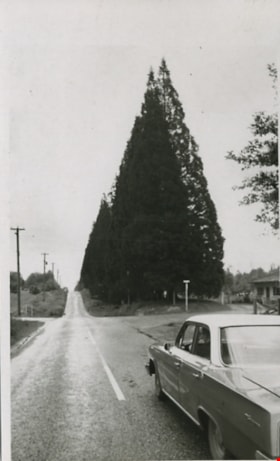
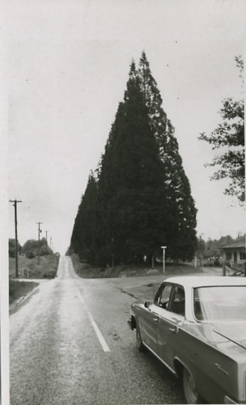
Scenic drive
https://search.heritageburnaby.ca/link/archivedescription56676
- Repository
- City of Burnaby Archives
- Date
- March 18, 1981
- Collection/Fonds
- Columbian Newspaper collection
- Description Level
- Item
- Physical Description
- 1 photograph : b&w ; 13.5 x 8.5 cm
- Scope and Content
- Photograph of a car driving down an unidentified road bordered along one side with large trees.
- Repository
- City of Burnaby Archives
- Date
- March 18, 1981
- Collection/Fonds
- Columbian Newspaper collection
- Physical Description
- 1 photograph : b&w ; 13.5 x 8.5 cm
- Description Level
- Item
- Record No.
- 480-457
- Access Restriction
- No restrictions
- Reproduction Restriction
- No restrictions
- Accession Number
- 2003-02
- Scope and Content
- Photograph of a car driving down an unidentified road bordered along one side with large trees.
- Subjects
- Geographic Features - Roads
- Media Type
- Photograph
- Photographer
- King, Basil
- Notes
- Title based on contents of photograph
- Note on verso of photograph reads: "The drive takes you" and "Scenic"
Images
![Sperling Avenue, [1987 or 1988] thumbnail](/media/hpo/_Data/_Archives_Images/_Unrestricted/204/204-805.jpg?width=280)
Sperling Avenue
https://search.heritageburnaby.ca/link/archivedescription35945
- Repository
- City of Burnaby Archives
- Date
- [1987 or 1988]
- Collection/Fonds
- Burnaby Historical Society fonds
- Description Level
- Item
- Physical Description
- 1 photograph : b&w ; 20.3 x 25.4 cm print
- Scope and Content
- Photograph of Sperling Avenue from above the hill at Deer Lake. This photograph was taken as a contemporary photograph to contrast item no. 204-749.
- Repository
- City of Burnaby Archives
- Date
- [1987 or 1988]
- Collection/Fonds
- Burnaby Historical Society fonds
- Subseries
- Pioneer Tales subseries
- Physical Description
- 1 photograph : b&w ; 20.3 x 25.4 cm print
- Description Level
- Item
- Record No.
- 204-805
- Access Restriction
- No restrictions
- Reproduction Restriction
- Reproduce for fair dealing purposes only
- Accession Number
- BHS1988-03
- Scope and Content
- Photograph of Sperling Avenue from above the hill at Deer Lake. This photograph was taken as a contemporary photograph to contrast item no. 204-749.
- Subjects
- Geographic Features - Roads
- Media Type
- Photograph
- Notes
- Title based on contents of photograph
- Geographic Access
- Sperling Avenue
- Historic Neighbourhood
- Burnaby Lake (Historic Neighbourhood)
- Planning Study Area
- Morley-Buckingham Area
Images
![Sperling Avenue, [1987 or 1988] thumbnail](/media/hpo/_Data/_Archives_Images/_Unrestricted/204/204-805.jpg)
![4674 Southlawn Drive, [1989 or 1990] (date of original), copied 1991 thumbnail](/media/hpo/_Data/_Archives_Images/_Unrestricted/370/370-463.jpg?width=280)
4674 Southlawn Drive
https://search.heritageburnaby.ca/link/archivedescription37875
- Repository
- City of Burnaby Archives
- Date
- [1989 or 1990] (date of original), copied 1991
- Collection/Fonds
- Burnaby Historical Society fonds
- Description Level
- Item
- Physical Description
- 1 photograph : b&w ; 3.7 x 4.7 cm print on contact sheet 20.1 x 26.7 cm
- Scope and Content
- Photograph taken from 4674 Southlawn Drive after a snowfall, facing northwest.
- Repository
- City of Burnaby Archives
- Date
- [1989 or 1990] (date of original), copied 1991
- Collection/Fonds
- Burnaby Historical Society fonds
- Subseries
- Burnaby Image Bank subseries
- Physical Description
- 1 photograph : b&w ; 3.7 x 4.7 cm print on contact sheet 20.1 x 26.7 cm
- Description Level
- Item
- Record No.
- 370-463
- Access Restriction
- No restrictions
- Reproduction Restriction
- No restrictions
- Accession Number
- BHS1999-03
- Scope and Content
- Photograph taken from 4674 Southlawn Drive after a snowfall, facing northwest.
- Media Type
- Photograph
- Notes
- Title based on contents of photograph
- 1 b&w copy negative accompanying
- Negative has a pink cast
- Copied from col. photograph
- Geographic Access
- Southlawn Drive
- Planning Study Area
- Brentwood Area
Images
![4674 Southlawn Drive, [1989 or 1990] (date of original), copied 1991 thumbnail](/media/hpo/_Data/_Archives_Images/_Unrestricted/370/370-463.jpg)
8357 Tenth Avenue, 8350 and 8353 Eleventh Avenue
https://search.heritageburnaby.ca/link/archivedescription93724
- Repository
- City of Burnaby Archives
- Date
- 1989
- Collection/Fonds
- Grover, Elliott & Co. Ltd. fonds
- Description Level
- File
- Physical Description
- 24 photographs : col. negatives ; 35 mm
- Scope and Content
- Photographs of the exterior of the low-rise apartment complex located at 8357 10th Avenue and 8350 and 8353 11th Avenue and the laneway running between the buildings.
- Repository
- City of Burnaby Archives
- Date
- 1989
- Collection/Fonds
- Grover, Elliott & Co. Ltd. fonds
- Physical Description
- 24 photographs : col. negatives ; 35 mm
- Description Level
- File
- Record No.
- 622-013
- Access Restriction
- No restrictions
- Reproduction Restriction
- No restrictions
- Accession Number
- 2017-39
- Scope and Content
- Photographs of the exterior of the low-rise apartment complex located at 8357 10th Avenue and 8350 and 8353 11th Avenue and the laneway running between the buildings.
- Media Type
- Photograph
- Notes
- Transcribed title
- Title transcribed from original print envelope
- Geographic Access
- 10th Avenue
- 11th Avenue
- Street Address
- 8357 10th Avenue
- 8350 11th Avenue
- 8353 11th Avenue
- Historic Neighbourhood
- East Burnaby (Historic Neighbourhood)
- Planning Study Area
- Cariboo-Armstrong Area

Looking south from 5496 Dominion Street
https://search.heritageburnaby.ca/link/archivedescription91863
- Repository
- City of Burnaby Archives
- Date
- September 1984
- Collection/Fonds
- Small family fonds
- Description Level
- Item
- Physical Description
- 1 photograph : col. ; 10 cm x 15 cm
- Scope and Content
- Photograph of the backyard at 5496 Dominion Street. Beyond the fence, the double garage built at 5495 Norfolk Street (right) and the original house at 5511 Norfolk Street (left) are visible. The photograph was taken from 5496 Dominion Street, looking south.
- Repository
- City of Burnaby Archives
- Date
- September 1984
- Collection/Fonds
- Small family fonds
- Physical Description
- 1 photograph : col. ; 10 cm x 15 cm
- Description Level
- Item
- Record No.
- 620-044
- Access Restriction
- No restrictions
- Reproduction Restriction
- No reproduction permitted
- Accession Number
- 2017-01
- Scope and Content
- Photograph of the backyard at 5496 Dominion Street. Beyond the fence, the double garage built at 5495 Norfolk Street (right) and the original house at 5511 Norfolk Street (left) are visible. The photograph was taken from 5496 Dominion Street, looking south.
- Media Type
- Photograph
- Notes
- Transcribed title
- Title transcribed from donor's notes
- Note in blue ink on verso of photograph reads: "P7"
- Note in black ink on verso of photograph reads: "5496 Dominion St. / Burnaby, B.C. / Sept. 1984"
- 5495 Norfolk Street was previously numbered 3155 Norfolk Street. The property was later subdivided into two lots: 5491 and 5497 Norfolk Street.
- 5511 Norfolk Street was previously numbered 3149 Norfolk Street. The property was later subdivided into two lots: 5503 and 5521 Norfolk Street.
- Street Address
- 5495 Norfolk Street
- 5496 Dominion Street
- 5511 Norfolk Street
- Historic Neighbourhood
- Burnaby Lake (Historic Neighbourhood)
- Planning Study Area
- Ardingley-Sprott Area
Images


Looking south from 5496 Dominion Street
https://search.heritageburnaby.ca/link/archivedescription91864
- Repository
- City of Burnaby Archives
- Date
- July 1989
- Collection/Fonds
- Small family fonds
- Description Level
- Item
- Physical Description
- 1 photograph : col. ; 10 cm x 15 cm
- Scope and Content
- Photograph of the backyard at 5496 Dominion Street. The backyard landscaping includes a cement pathway and vegetable garden. The photograph was taken from 5496 Dominion Street, looking south.
- Repository
- City of Burnaby Archives
- Date
- July 1989
- Collection/Fonds
- Small family fonds
- Physical Description
- 1 photograph : col. ; 10 cm x 15 cm
- Description Level
- Item
- Record No.
- 620-045
- Access Restriction
- No restrictions
- Reproduction Restriction
- No reproduction permitted
- Accession Number
- 2017-01
- Scope and Content
- Photograph of the backyard at 5496 Dominion Street. The backyard landscaping includes a cement pathway and vegetable garden. The photograph was taken from 5496 Dominion Street, looking south.
- Media Type
- Photograph
- Notes
- Transcribed title
- Title transcribed from donor's notes
- Note in blue ink on verso of photograph reads: "P8"
- Note in black ink on verso of photograph reads: "July 1989"
- Street Address
- 5496 Dominion Street
- Historic Neighbourhood
- Burnaby Lake (Historic Neighbourhood)
- Planning Study Area
- Ardingley-Sprott Area
Images


Trail through the woods of Stoney Creek School
https://search.heritageburnaby.ca/link/archivedescription58924
- Repository
- City of Burnaby Archives
- Date
- ca.1980
- Collection/Fonds
- Columbian Newspaper collection
- Description Level
- Item
- Physical Description
- 1 photograph : b&w ; 25.5 x 20.5 cm
- Scope and Content
- Photograph of a paved trail through the woods by Stoney Creek Community School. A parking lot with cars is visible at the end of the trail.
- Repository
- City of Burnaby Archives
- Date
- ca.1980
- Collection/Fonds
- Columbian Newspaper collection
- Physical Description
- 1 photograph : b&w ; 25.5 x 20.5 cm
- Description Level
- Item
- Record No.
- 480-1375
- Access Restriction
- No restrictions
- Reproduction Restriction
- Reproduce for fair dealing purposes only
- Accession Number
- 2009-01
- Scope and Content
- Photograph of a paved trail through the woods by Stoney Creek Community School. A parking lot with cars is visible at the end of the trail.
- Media Type
- Photograph
- Photographer
- King, Basil
- Notes
- Title based on contents of photograph
- Note on recto reads: "Trail thru woods & Stoney Creek School"
- Note on verso reads: "PMT 100% / page 1 / Burnaby Today"
- Photographer's stamp on verso
- Street Address
- 2740 Beaverbrook Crescent
- Historic Neighbourhood
- Burquitlam (Historic Neighbourhood)
- Planning Study Area
- Lyndhurst Area
Images


Canada geese in the park
https://search.heritageburnaby.ca/link/archivedescription59046
- Repository
- City of Burnaby Archives
- Date
- ca.1983
- Collection/Fonds
- Columbian Newspaper collection
- Description Level
- Item
- Physical Description
- 1 photograph : b&w ; 17.5 x 20 cm
- Scope and Content
- Photograph of a flock of Canada geese on a grassy field in a park.
- Repository
- City of Burnaby Archives
- Date
- ca.1983
- Collection/Fonds
- Columbian Newspaper collection
- Physical Description
- 1 photograph : b&w ; 17.5 x 20 cm
- Description Level
- Item
- Record No.
- 480-1452
- Access Restriction
- No restrictions
- Reproduction Restriction
- Reproduce for fair dealing purposes only
- Accession Number
- 2009-01
- Scope and Content
- Photograph of a flock of Canada geese on a grassy field in a park.
- Subjects
- Geographic Features - Fields
- Geographic Features - Lakes and Ponds
- Geographic Features - Parks
- Animals - Birds
- Media Type
- Photograph
- Photographer
- Battistoni, Peter
- Notes
- Title based on contents of photograph
- Photographer's stamp on verso
- Note on verso reads: "page 4 / Burnaby / Today / PMT 100%"
Images

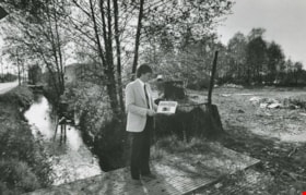
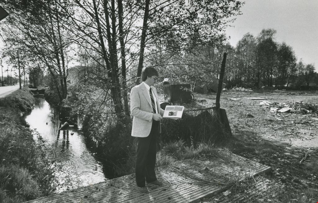
Man in the park
https://search.heritageburnaby.ca/link/archivedescription58992
- Repository
- City of Burnaby Archives
- Date
- 1983
- Collection/Fonds
- Columbian Newspaper collection
- Description Level
- Item
- Physical Description
- 1 photograph : b&w ; 18 x 25.5 cm
- Scope and Content
- Photograph of a man in a suit next to an empty lot or park. He is standing on a plank bridge over a ditch by the road that is filled with water and reviewing a book or report.
- Repository
- City of Burnaby Archives
- Date
- 1983
- Collection/Fonds
- Columbian Newspaper collection
- Physical Description
- 1 photograph : b&w ; 18 x 25.5 cm
- Description Level
- Item
- Record No.
- 480-1402
- Access Restriction
- No restrictions
- Reproduction Restriction
- No restrictions
- Accession Number
- 2009-01
- Scope and Content
- Photograph of a man in a suit next to an empty lot or park. He is standing on a plank bridge over a ditch by the road that is filled with water and reviewing a book or report.
- Media Type
- Photograph
- Photographer
- Battistoni, Peter
- Notes
- Title based on contents of photograph
- Photographer's stamp on verso
- Note on verso reads: "PMT 100% / page A-3 / Burnaby Today"
Images
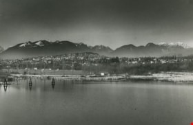
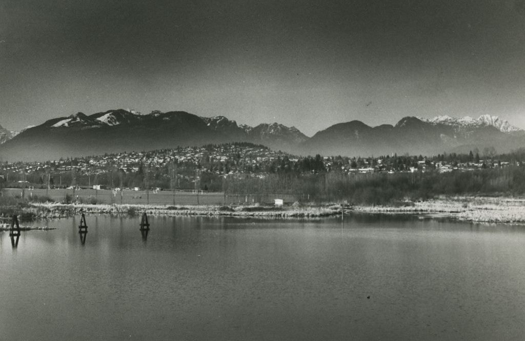
View of a Lake, City, and Mountains
https://search.heritageburnaby.ca/link/archivedescription59024
- Repository
- City of Burnaby Archives
- Date
- ca.1983
- Collection/Fonds
- Columbian Newspaper collection
- Description Level
- Item
- Physical Description
- 1 photograph : b&w
- Scope and Content
- Photograph of a lake and residential neighbourhood, with the North Shore mountains in the background.
- Repository
- City of Burnaby Archives
- Date
- ca.1983
- Collection/Fonds
- Columbian Newspaper collection
- Physical Description
- 1 photograph : b&w
- Description Level
- Item
- Record No.
- 480-1430
- Access Restriction
- No restrictions
- Reproduction Restriction
- Reproduce for fair dealing purposes only
- Accession Number
- 2009-01
- Scope and Content
- Photograph of a lake and residential neighbourhood, with the North Shore mountains in the background.
- Subjects
- Geographic Features - Beaches
- Geographic Features - Lakes and Ponds
- Geographic Features - Mountains
- Media Type
- Photograph
- Photographer
- King, Basil
- Notes
- Title based on contents of photograph
Images