More like '8855 Northbrook Court'
Narrow Results By
Decade
- 2020s 4
- 2010s 12
- 2000s 102
- 1990s 88
- 1980s 92
- 1970s 164
- 1960s 47
- 1950s 87
- 1940s 216
- 1930s 56
- 1920s 113
- 1910s 128
- 1900s 58
- 1890s 18
- 1880s 5
- 1870s 3
- 1860s 3
- 1850s 1
- 1810s 1
- 1800s 1
- 1790s 1
- 1780s 1
- 1770s 1
- 1760s 1
- 1750s 1
- 1740s 1
- 1730s 1
- 1720s 1
- 1710s 1
- 1700s 1
- 1690s 1
- 1680s 1
- 1670s 1
- 1660s 1
- 1650s 1
- 1640s 1
- 1630s 1
- 1620s 1
- 1610s 1
- 1600s 1
- 1590s 1
- 1580s 1
- 1570s 1
- 1560s 1
- 1550s 1
- 1540s 1
- 1530s 1
- 1520s 1
- 1510s 1
- 1500s 1
- 1490s 1
- 1480s 1
Subject
- Advertising Medium 15
- Advertising Medium - Business Cards 8
- Advertising Medium - Flyer 2
- Advertising Medium - Signs and Signboards 9
- Aerial Photographs 7
- Agricultural Tools and Equipment 29
- Agricultural Tools and Equipment - Cultivators 3
- Agricultural Tools and Equipment - Gardening Equipment 13
- Agricultural Tools and Equipment - Plows 9
- Agricultural Tools and Equipment - Tractors 1
- Agriculture 2
- Agriculture - Beekeeping 3
Dominion Bridge Co. Ltd.
https://search.heritageburnaby.ca/link/archivedescription34681
- Repository
- City of Burnaby Archives
- Date
- January 1956
- Collection/Fonds
- Burnaby Historical Society fonds
- Description Level
- Item
- Physical Description
- 1 photograph : b&w ; 20.5 x 25.3 cm
- Scope and Content
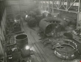
- Photograph of the fabrication of large construction industry components inside a Dominion Bridge Co. Ltd. building.
- Repository
- City of Burnaby Archives
- Date
- January 1956
- Collection/Fonds
- Burnaby Historical Society fonds
- Subseries
- Photographs subseries
- Physical Description
- 1 photograph : b&w ; 20.5 x 25.3 cm
- Description Level
- Item
- Record No.
- 092-002
- Access Restriction
- No restrictions
- Reproduction Restriction
- Reproduce for fair dealing purposes only
- Accession Number
- BHS2007-04
- Scope and Content
- Photograph of the fabrication of large construction industry components inside a Dominion Bridge Co. Ltd. building.
- Names
- Dominion Bridge Company
- Media Type
- Photograph
- Photographer
- Graphic Industries Limited
- Notes
- Title based on contents of photograph
- Printed on bottom of photo, "Dominion Bridge Co., Limited / Pacific Division"
- Printed on back of cardboard "GIL: Graphic Industries Ltd. / 54 West Hastings, Vancouver 4, B.C. / Phone Pacific 4174 File No: 2844 1"
- Stamped and annotated on back of cardboard, "Dominion Bridge Co. Ltd. / Vancouver, B.C. / Neg./Print #55-DB-3-32" and "Jan. /56"
- Geographic Access
- Henning Drive
- Street Address
- 3880 Henning Drive
- Historic Neighbourhood
- Broadview (Historic Neighbourhood)
- Planning Study Area
- West Central Valley Area
Images


Dominion Bridge Co. Ltd.
https://search.heritageburnaby.ca/link/archivedescription34682
- Repository
- City of Burnaby Archives
- Date
- January 25, 1957
- Collection/Fonds
- Burnaby Historical Society fonds
- Description Level
- Item
- Physical Description
- 1 photograph : b&w ; 20.5 x 25.4 cm
- Scope and Content
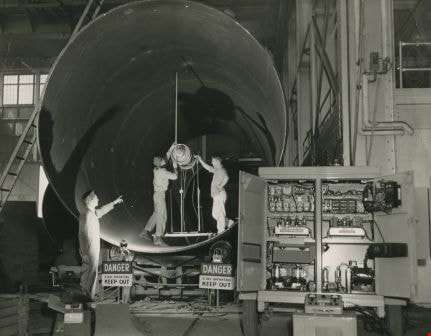
- Photograph of the interior of a Dominion Bridge Co. Ltd. building. Three men are working on a large pipe. Two signs read, "Danger / X-Ray Operating / Keep Out."
- Repository
- City of Burnaby Archives
- Date
- January 25, 1957
- Collection/Fonds
- Burnaby Historical Society fonds
- Subseries
- Photographs subseries
- Physical Description
- 1 photograph : b&w ; 20.5 x 25.4 cm
- Description Level
- Item
- Record No.
- 092-003
- Access Restriction
- No restrictions
- Reproduction Restriction
- Reproduce for fair dealing purposes only
- Accession Number
- BHS2007-04
- Scope and Content
- Photograph of the interior of a Dominion Bridge Co. Ltd. building. Three men are working on a large pipe. Two signs read, "Danger / X-Ray Operating / Keep Out."
- Names
- Dominion Bridge Company
- Media Type
- Photograph
- Notes
- Title based on contents of photograph
- Printed on bottom of photo, "Dominion Bridge Co., Limited / Pacific Division"
- Stamps on back of photograph read, "Dominion Bridge Company, Limited" and "Jan 25 1957"
- Geographic Access
- Henning Drive
- Street Address
- 3880 Henning Drive
- Historic Neighbourhood
- Broadview (Historic Neighbourhood)
- Planning Study Area
- West Central Valley Area
Images
Dominion Bridge Co. Ltd.
https://search.heritageburnaby.ca/link/archivedescription34683
- Repository
- City of Burnaby Archives
- Date
- 1957
- Collection/Fonds
- Burnaby Historical Society fonds
- Description Level
- Item
- Physical Description
- 1 photograph : b&w ; 20.4 x 25.4 cm
- Scope and Content
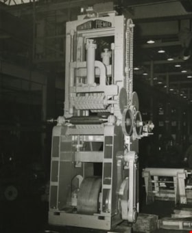
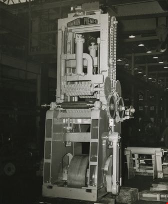
- Photograph of the interior of a Dominion Bridge Co. Ltd. building with a piece of machinery with a plate reading, "Dominion Premier" on it.
- Repository
- City of Burnaby Archives
- Date
- 1957
- Collection/Fonds
- Burnaby Historical Society fonds
- Subseries
- Photographs subseries
- Physical Description
- 1 photograph : b&w ; 20.4 x 25.4 cm
- Description Level
- Item
- Record No.
- 092-004
- Access Restriction
- No restrictions
- Reproduction Restriction
- Reproduce for fair dealing purposes only
- Accession Number
- BHS2007-04
- Scope and Content
- Photograph of the interior of a Dominion Bridge Co. Ltd. building with a piece of machinery with a plate reading, "Dominion Premier" on it.
- Names
- Dominion Bridge Company
- Media Type
- Photograph
- Notes
- Title based on contents of photograph
- Printed on bottom of photo, "Dominion Bridge Co., Limited / Pacific Division"
- Stamp on back of photo reads, "Dominion Bridge Co., Ltd. / Vancouver, B.C. / Neg./Print # 57-329"
- Geographic Access
- Henning Drive
- Street Address
- 3880 Henning Drive
- Historic Neighbourhood
- Broadview (Historic Neighbourhood)
- Planning Study Area
- West Central Valley Area
Images

Gilmore Avenue and Douglas Road
https://search.heritageburnaby.ca/link/archivedescription34112
- Repository
- City of Burnaby Archives
- Date
- March 27, 1947
- Collection/Fonds
- Burnaby Historical Society fonds
- Description Level
- Item
- Physical Description
- 1 photograph : b&w negative ; 6.8 x 11.6 cm
- Scope and Content
- Photograph of Gilmore Avenue and Douglas Road with a car parked at the side of the road and two men with surveying equipment. This is part of the Willingdon Heights subdivision site.
- Repository
- City of Burnaby Archives
- Date
- March 27, 1947
- Collection/Fonds
- Burnaby Historical Society fonds
- Subseries
- Alfred Bingham subseries
- Physical Description
- 1 photograph : b&w negative ; 6.8 x 11.6 cm
- Description Level
- Item
- Record No.
- 010-028
- Access Restriction
- No restrictions
- Reproduction Restriction
- No known restrictions
- Accession Number
- BHS2007-04
- Scope and Content
- Photograph of Gilmore Avenue and Douglas Road with a car parked at the side of the road and two men with surveying equipment. This is part of the Willingdon Heights subdivision site.
- Subjects
- Industries - Construction
- Buildings - Residential - Houses
- Construction Tools and Equipment
- Media Type
- Photograph
- Photographer
- Bingham, Alfred "Alf"
- Notes
- Title based on contents of photograph
- Geographic Access
- Gilmore Avenue
- Douglas Road
Images

![Korean TV crew at a construction site, [1999] thumbnail](/media/hpo/_Data/_Archives_Images/_Unrestricted/535/535-3233.jpg?width=280)
Korean TV crew at a construction site
https://search.heritageburnaby.ca/link/archivedescription98155
- Repository
- City of Burnaby Archives
- Date
- [1999]
- Collection/Fonds
- Burnaby NewsLeader photograph collection
- Description Level
- Item
- Physical Description
- 1 photograph (tiff) : col.
- Scope and Content
- Photograph of an unidentified camera operator from a Korean TV crew filming a person driving a forklift on a construction site, with a concrete mixer in the background.
- Repository
- City of Burnaby Archives
- Date
- [1999]
- Collection/Fonds
- Burnaby NewsLeader photograph collection
- Physical Description
- 1 photograph (tiff) : col.
- Description Level
- Item
- Record No.
- 535-3233
- Access Restriction
- No restrictions
- Reproduction Restriction
- No restrictions
- Accession Number
- 2018-12
- Scope and Content
- Photograph of an unidentified camera operator from a Korean TV crew filming a person driving a forklift on a construction site, with a concrete mixer in the background.
- Media Type
- Photograph
- Notes
- Title based on original file name
- Collected by editorial for use in a June 1999 issue of the Burnaby NewsLeader
Images
![Korean TV crew at a construction site, [1999] thumbnail](/media/hpo/_Data/_Archives_Images/_Unrestricted/535/535-3233.jpg)
![Local construction, [1999] thumbnail](/media/hpo/_Data/_Archives_Images/_Unrestricted/535/535-3205-1.jpg?width=280)
Local construction
https://search.heritageburnaby.ca/link/archivedescription98126
- Repository
- City of Burnaby Archives
- Date
- [1999]
- Collection/Fonds
- Burnaby NewsLeader photograph collection
- Description Level
- File
- Physical Description
- 2 photographs (tiff) : col.
- Scope and Content
- File contains photographs of two unidentified people observing evidence of construction. One photograph depicts a person looking at a crack in a floor tile while holding a land survey map, and the other depicts an individual looking at a piece of construction equipment on the other side of a chain …
- Repository
- City of Burnaby Archives
- Date
- [1999]
- Collection/Fonds
- Burnaby NewsLeader photograph collection
- Physical Description
- 2 photographs (tiff) : col.
- Description Level
- File
- Record No.
- 535-3205
- Access Restriction
- No restrictions
- Reproduction Restriction
- No restrictions
- Accession Number
- 2018-12
- Scope and Content
- File contains photographs of two unidentified people observing evidence of construction. One photograph depicts a person looking at a crack in a floor tile while holding a land survey map, and the other depicts an individual looking at a piece of construction equipment on the other side of a chain link fence.
- Media Type
- Photograph
- Notes
- Title based on contents of file
- Collected by editorial for use in a June 1999 issue of the Burnaby NewsLeader
Images
![Local construction, [1999] thumbnail](/media/hpo/_Data/_Archives_Images/_Unrestricted/535/535-3205-1.jpg)

London mixer and contractors
https://search.heritageburnaby.ca/link/archivedescription34138
- Repository
- City of Burnaby Archives
- Date
- April 16, 1947
- Collection/Fonds
- Burnaby Historical Society fonds
- Description Level
- Item
- Physical Description
- 1 photograph : b&w negative ; 6.8 x 11.8 cm
- Scope and Content
- Photograph of Gilmore Avenue and Douglas Road including a London mixer and contractors invovled in house construction. The man standing in the center has been identified as Mr. Marcowitz. This is part of the Willingdon Heights subdivision site.
- Repository
- City of Burnaby Archives
- Date
- April 16, 1947
- Collection/Fonds
- Burnaby Historical Society fonds
- Subseries
- Alfred Bingham subseries
- Physical Description
- 1 photograph : b&w negative ; 6.8 x 11.8 cm
- Description Level
- Item
- Record No.
- 010-054
- Access Restriction
- No restrictions
- Reproduction Restriction
- Reproduce for fair dealing purposes only
- Accession Number
- BHS2007-04
- Scope and Content
- Photograph of Gilmore Avenue and Douglas Road including a London mixer and contractors invovled in house construction. The man standing in the center has been identified as Mr. Marcowitz. This is part of the Willingdon Heights subdivision site.
- Subjects
- Occupations - Labourers
- Industries - Construction
- Construction Tools and Equipment
- Buildings - Residential - Houses
- Media Type
- Photograph
- Photographer
- Bingham, Alfred "Alf"
- Notes
- Title based on contents of photograph
- Geographic Access
- Gilmore Avenue
- Douglas Road
Images

Napier Street and Willingdon Avenue
https://search.heritageburnaby.ca/link/archivedescription34223
- Repository
- City of Burnaby Archives
- Date
- July 10, 1947
- Collection/Fonds
- Burnaby Historical Society fonds
- Description Level
- Item
- Physical Description
- 1 photograph : b&w negative ; 6.8 x 11.4 cm
- Scope and Content
- Photograph of Napier Street and Willingdon Avenue with lumber scattered on a cleared area and houses in the background. There are vehicles on the road, including a truck whose side reads "Mother Hubbard Bread" and machinery reading "G.W. Ledingham, Contractors." This is part of the Willingdon Hei…
- Repository
- City of Burnaby Archives
- Date
- July 10, 1947
- Collection/Fonds
- Burnaby Historical Society fonds
- Subseries
- Alfred Bingham subseries
- Physical Description
- 1 photograph : b&w negative ; 6.8 x 11.4 cm
- Description Level
- Item
- Record No.
- 010-138
- Access Restriction
- No restrictions
- Reproduction Restriction
- No known restrictions
- Accession Number
- BHS2007-04
- Scope and Content
- Photograph of Napier Street and Willingdon Avenue with lumber scattered on a cleared area and houses in the background. There are vehicles on the road, including a truck whose side reads "Mother Hubbard Bread" and machinery reading "G.W. Ledingham, Contractors." This is part of the Willingdon Heights subdivision site.
- Media Type
- Photograph
- Photographer
- Bingham, Alfred "Alf"
- Notes
- Title based on contents of photograph
- Geographic Access
- Napier Street
- Willingdon Avenue
Images

![New building under construction, [1964 or 1965] thumbnail](/media/hpo/_Data/_Archives_Images/_Unrestricted/480/480-414.jpg?width=280)
New building under construction
https://search.heritageburnaby.ca/link/archivedescription45519
- Repository
- City of Burnaby Archives
- Date
- [1964 or 1965]
- Collection/Fonds
- Columbian Newspaper collection
- Description Level
- Item
- Physical Description
- 1 photograph : b&w ; 23.5 x 36.5 cm
- Scope and Content
- Photograph of a new building at Simon Fraser University under construction.
- Repository
- City of Burnaby Archives
- Date
- [1964 or 1965]
- Collection/Fonds
- Columbian Newspaper collection
- Physical Description
- 1 photograph : b&w ; 23.5 x 36.5 cm
- Description Level
- Item
- Record No.
- 480-414
- Access Restriction
- No restrictions
- Reproduction Restriction
- Reproduce for fair dealing purposes only
- Accession Number
- 2003-02
- Scope and Content
- Photograph of a new building at Simon Fraser University under construction.
- Names
- Simon Fraser University
- Media Type
- Photograph
- Photographer
- Donnelly, David
- Notes
- Title based on contents of photograph
Images
![New building under construction, [1964 or 1965] thumbnail](/media/hpo/_Data/_Archives_Images/_Unrestricted/480/480-414.jpg)
Rosser Avenue and William Street
https://search.heritageburnaby.ca/link/archivedescription34186
- Repository
- City of Burnaby Archives
- Date
- May 26, 1947
- Collection/Fonds
- Burnaby Historical Society fonds
- Description Level
- Item
- Physical Description
- 1 photograph : b&w negative ; 6.8 x 11.3 cm
- Scope and Content
- Photograph of Rosser Avenue and William Street with pipes being laid beside the road. Cleared land, houses and house construction are visible in the background. This is part of the Willingdon Heights subdivision site.
- Repository
- City of Burnaby Archives
- Date
- May 26, 1947
- Collection/Fonds
- Burnaby Historical Society fonds
- Subseries
- Alfred Bingham subseries
- Physical Description
- 1 photograph : b&w negative ; 6.8 x 11.3 cm
- Description Level
- Item
- Record No.
- 010-103
- Access Restriction
- No restrictions
- Reproduction Restriction
- No known restrictions
- Accession Number
- BHS2007-04
- Scope and Content
- Photograph of Rosser Avenue and William Street with pipes being laid beside the road. Cleared land, houses and house construction are visible in the background. This is part of the Willingdon Heights subdivision site.
- Media Type
- Photograph
- Photographer
- Bingham, Alfred "Alf"
- Notes
- Title based on contents of photograph
- Geographic Access
- Rosser Avenue
- William Street
Images
![Two bulldozers, [194-] thumbnail](/media/hpo/_Data/_BVM_Images/1971/197100120076.jpg?width=280)
Two bulldozers
https://search.heritageburnaby.ca/link/museumdescription8
- Repository
- Burnaby Village Museum
- Date
- [194-]
- Collection/Fonds
- Burnaby Village Museum Photograph collection
- Description Level
- Item
- Physical Description
- 1 photograph : b&w ; 6.8 x 11.4 cm
- Scope and Content
- Photograph of two bulldozers, belonging to "Holmes & Wilson Trucking", clearing a lot beside a row of houses. Building materials (bricks and lumber) are piled nearby. This may be related to the construction of the Willingdon Heights subdivision. Stamp on back of photograph reads: "342x."
- Repository
- Burnaby Village Museum
- Collection/Fonds
- Burnaby Village Museum Photograph collection
- Description Level
- Item
- Physical Description
- 1 photograph : b&w ; 6.8 x 11.4 cm
- Scope and Content
- Photograph of two bulldozers, belonging to "Holmes & Wilson Trucking", clearing a lot beside a row of houses. Building materials (bricks and lumber) are piled nearby. This may be related to the construction of the Willingdon Heights subdivision. Stamp on back of photograph reads: "342x."
- Subjects
- Industries - Construction
- Buildings - Residential - Houses
- Construction Tools and Equipment
- Names
- Bingham, Alfred "Alf"
- Accession Code
- HV971.12.76
- Access Restriction
- No restrictions
- Reproduction Restriction
- No known restrictions
- Date
- [194-]
- Media Type
- Photograph
- Historic Neighbourhood
- Vancouver Heights (Historic Neighbourhood)
- Planning Study Area
- Willingdon Heights Area
- Scan Resolution
- 600
- Scan Date
- 2023-03-21
- Notes
- Title based on contents of photograph
Images
![Two bulldozers, [194-] thumbnail](/media/hpo/_Data/_BVM_Images/1971/197100120076.jpg)
![Land surveyor on a road, [1999] thumbnail](/media/hpo/_Data/_Archives_Images/_Unrestricted/535/535-3313.jpg?width=280)
Land surveyor on a road
https://search.heritageburnaby.ca/link/archivedescription98246
- Repository
- City of Burnaby Archives
- Date
- [1999]
- Collection/Fonds
- Burnaby NewsLeader photograph collection
- Description Level
- Item
- Physical Description
- 1 photograph (tiff) : b&w
- Scope and Content
- Photograph of an unidentified land surveyor standing behind a land surveying total station at the curve of a road.
- Repository
- City of Burnaby Archives
- Date
- [1999]
- Collection/Fonds
- Burnaby NewsLeader photograph collection
- Physical Description
- 1 photograph (tiff) : b&w
- Description Level
- Item
- Record No.
- 535-3313
- Access Restriction
- No restrictions
- Reproduction Restriction
- No restrictions
- Accession Number
- 2018-12
- Scope and Content
- Photograph of an unidentified land surveyor standing behind a land surveying total station at the curve of a road.
- Media Type
- Photograph
- Notes
- Title based on contents of photograph
- Collected by editorial for use in a September 1999 issue of the Burnaby NewsLeader
Images
![Land surveyor on a road, [1999] thumbnail](/media/hpo/_Data/_Archives_Images/_Unrestricted/535/535-3313.jpg)
1160 Douglas Rd
https://search.heritageburnaby.ca/link/archivedescription94327
- Repository
- City of Burnaby Archives
- Date
- December 1994
- Collection/Fonds
- Grover, Elliott & Co. Ltd. fonds
- Description Level
- File
- Physical Description
- 22 photographs : col. negatives ; 35 mm
- Scope and Content
- Photographs of the exterior of a three-storey commerical building located at 1160 Douglas Road.
- Repository
- City of Burnaby Archives
- Date
- December 1994
- Collection/Fonds
- Grover, Elliott & Co. Ltd. fonds
- Physical Description
- 22 photographs : col. negatives ; 35 mm
- Description Level
- File
- Record No.
- 622-112
- Access Restriction
- No restrictions
- Reproduction Restriction
- No restrictions
- Accession Number
- 2017-39
- Scope and Content
- Photographs of the exterior of a three-storey commerical building located at 1160 Douglas Road.
- Media Type
- Photograph
- Photographer
- Young, Richard
- Notes
- Transcribed title
- Title transcribed from envelope photographs were originally housed in
- File no. 94-424-B
- Geographic Access
- Douglas Road
- Street Address
- 1160 Douglas Road
- Historic Neighbourhood
- Vancouver Heights (Historic Neighbourhood)
- Planning Study Area
- Willingdon Heights Area
4010 Regent St.
https://search.heritageburnaby.ca/link/archivedescription94318
- Repository
- City of Burnaby Archives
- Date
- September 1994
- Collection/Fonds
- Grover, Elliott & Co. Ltd. fonds
- Description Level
- File
- Physical Description
- 25 photographs : col. negatives ; 35 mm
- Scope and Content
- Photographs of an undeveloped property located at 4010 Regent Street. Property is covered with soil, brush, and some trees.
- Repository
- City of Burnaby Archives
- Date
- September 1994
- Collection/Fonds
- Grover, Elliott & Co. Ltd. fonds
- Physical Description
- 25 photographs : col. negatives ; 35 mm
- Description Level
- File
- Record No.
- 622-103
- Access Restriction
- No restrictions
- Reproduction Restriction
- No restrictions
- Accession Number
- 2017-39
- Scope and Content
- Photographs of an undeveloped property located at 4010 Regent Street. Property is covered with soil, brush, and some trees.
- Subjects
- Land Clearing
- Media Type
- Photograph
- Photographer
- Young, Richard
- Notes
- Transcribed title
- Title transcribed from envelope photographs were originally housed in
- File no. 94-342-B
- Geographic Access
- Regent Street
- Street Address
- 4010 Regent Street
- Historic Neighbourhood
- Broadview (Historic Neighbourhood)
- Planning Study Area
- West Central Valley Area
5200 Oakmount Cr.
https://search.heritageburnaby.ca/link/archivedescription94313
- Repository
- City of Burnaby Archives
- Date
- June 1994
- Collection/Fonds
- Grover, Elliott & Co. Ltd. fonds
- Description Level
- File
- Physical Description
- 23 photographs : col. negatives ; 35 mm
- Scope and Content
- Photographs of an undeveloped property located at 5200 Oakmount Crescent - an address that no longer exists.
- Repository
- City of Burnaby Archives
- Date
- June 1994
- Collection/Fonds
- Grover, Elliott & Co. Ltd. fonds
- Physical Description
- 23 photographs : col. negatives ; 35 mm
- Description Level
- File
- Record No.
- 622-098
- Access Restriction
- No restrictions
- Reproduction Restriction
- No restrictions
- Accession Number
- 2017-39
- Scope and Content
- Photographs of an undeveloped property located at 5200 Oakmount Crescent - an address that no longer exists.
- Subjects
- Land Clearing
- Media Type
- Photograph
- Notes
- Transcribed title
- Title transcribed from envelope photographs were originally housed in
- File no. 94-236-B
- Photographer identified as "J.C."
- Geographic Access
- Oakmount Crescent
- Historic Neighbourhood
- Central Park (Historic Neighbourhood)
- Planning Study Area
- Windsor Area
5548 Marshland Ave
https://search.heritageburnaby.ca/link/archivedescription94302
- Repository
- City of Burnaby Archives
- Date
- January 1994
- Collection/Fonds
- Grover, Elliott & Co. Ltd. fonds
- Description Level
- File
- Physical Description
- 25 photographs : col. negatives ; 35 mm
- Scope and Content
- Photographs of an undeveloped property located at 5548 Marshland Avenue - an address that no longer exists.
- Repository
- City of Burnaby Archives
- Date
- January 1994
- Collection/Fonds
- Grover, Elliott & Co. Ltd. fonds
- Physical Description
- 25 photographs : col. negatives ; 35 mm
- Description Level
- File
- Record No.
- 622-087
- Access Restriction
- No restrictions
- Reproduction Restriction
- No restrictions
- Accession Number
- 2017-39
- Scope and Content
- Photographs of an undeveloped property located at 5548 Marshland Avenue - an address that no longer exists.
- Subjects
- Land Clearing
- Media Type
- Photograph
- Notes
- Transcribed title
- Title transcribed from envelope photographs were originally housed in
- File no. 94-023-B
- Photographer identified as "K.D."
- Geographic Access
- Marshland Avenue
- Historic Neighbourhood
- Fraser Arm (Historic Neighbourhood)
- Planning Study Area
- Big Bend Area

6113 Silver Avenue lot
https://search.heritageburnaby.ca/link/archivedescription37775
- Repository
- City of Burnaby Archives
- Date
- 1986 (date of original), copied 1991
- Collection/Fonds
- Burnaby Historical Society fonds
- Description Level
- Item
- Physical Description
- 1 photograph : b&w ; 3.1 x 4.4 cm print on contact sheet 20.3 x 26.2 cm
- Scope and Content
- Photograph of the lot at 6113 Silver Avenue, the former home of the Ellis family. The house has been demolished and an empty lot remains. Houses, aparment buildings, and the Expo line skytrain track with cars on it can be seen in the background.
- Repository
- City of Burnaby Archives
- Date
- 1986 (date of original), copied 1991
- Collection/Fonds
- Burnaby Historical Society fonds
- Subseries
- Burnaby Image Bank subseries
- Physical Description
- 1 photograph : b&w ; 3.1 x 4.4 cm print on contact sheet 20.3 x 26.2 cm
- Description Level
- Item
- Record No.
- 370-363
- Access Restriction
- No restrictions
- Reproduction Restriction
- No restrictions
- Accession Number
- BHS1999-03
- Scope and Content
- Photograph of the lot at 6113 Silver Avenue, the former home of the Ellis family. The house has been demolished and an empty lot remains. Houses, aparment buildings, and the Expo line skytrain track with cars on it can be seen in the background.
- Subjects
- Land Clearing
- Media Type
- Photograph
- Notes
- Title based on contents of photograph
- 1 b&w copy negative accompanying
- Negative has a pink cast
- Copied from col. photograph
- Geographic Access
- Silver Avenue
- Street Address
- 6113 Silver Avenue
- Historic Neighbourhood
- Central Park (Historic Neighbourhood)
- Planning Study Area
- Maywood Area
Images

7026 Kingsway
https://search.heritageburnaby.ca/link/archivedescription94304
- Repository
- City of Burnaby Archives
- Date
- January 1994
- Collection/Fonds
- Grover, Elliott & Co. Ltd. fonds
- Description Level
- File
- Physical Description
- 19 photographs : col. negatives ; 35 mm
- Scope and Content
- Photographs of commercial and undeveloped properties located in the 7100 block of Kingsway, including Middlegate Honda, with mid-rise towers visible in the background.
- Repository
- City of Burnaby Archives
- Date
- January 1994
- Collection/Fonds
- Grover, Elliott & Co. Ltd. fonds
- Physical Description
- 19 photographs : col. negatives ; 35 mm
- Description Level
- File
- Record No.
- 622-089
- Access Restriction
- No restrictions
- Reproduction Restriction
- No restrictions
- Accession Number
- 2017-39
- Scope and Content
- Photographs of commercial and undeveloped properties located in the 7100 block of Kingsway, including Middlegate Honda, with mid-rise towers visible in the background.
- Media Type
- Photograph
- Notes
- Transcribed title
- Title transcribed from envelope photographs were originally housed in
- File no. 94-028-B
- Photographer identified as "L.D."
- Geographic Access
- Kingsway
- Historic Neighbourhood
- Edmonds (Historic Neighbourhood)
- Planning Study Area
- Stride Avenue Area
8980 Fraserwood Crt
https://search.heritageburnaby.ca/link/archivedescription94326
- Repository
- City of Burnaby Archives
- Date
- December 1994
- Collection/Fonds
- Grover, Elliott & Co. Ltd. fonds
- Description Level
- File
- Physical Description
- 24 photographs : col. negatives ; 35 mm
- Scope and Content
- Photographs of an undeveloped property located at 8980 Fraserwood Court. A Sutton Group real estate sign on the property advertises the site as the Fraserwood Corporate Centre with strata warehouse and office flex space. File also contains photographs of the commerical building adjacent to the si…
- Repository
- City of Burnaby Archives
- Date
- December 1994
- Collection/Fonds
- Grover, Elliott & Co. Ltd. fonds
- Physical Description
- 24 photographs : col. negatives ; 35 mm
- Description Level
- File
- Record No.
- 622-111
- Access Restriction
- No restrictions
- Reproduction Restriction
- No restrictions
- Accession Number
- 2017-39
- Scope and Content
- Photographs of an undeveloped property located at 8980 Fraserwood Court. A Sutton Group real estate sign on the property advertises the site as the Fraserwood Corporate Centre with strata warehouse and office flex space. File also contains photographs of the commerical building adjacent to the site.
- Media Type
- Photograph
- Notes
- Transcribed title
- Title transcribed from envelope photographs were originally housed in
- File no. 94-422-B
- Photographer identified as "L.D."
- Geographic Access
- Fraserwood Court
- Street Address
- 8980 Fraserwood Court
- Historic Neighbourhood
- Fraser Arm (Historic Neighbourhood)
- Planning Study Area
- Big Bend Area
![Ada Bingham by a tree stump, [1948] thumbnail](/media/hpo/_Data/_BVM_Images/1976/1976_0046_0005_001.jpg?width=280)
Ada Bingham by a tree stump
https://search.heritageburnaby.ca/link/museumdescription739
- Repository
- Burnaby Village Museum
- Date
- [1948]
- Collection/Fonds
- Burnaby Village Museum Photograph collection
- Description Level
- Item
- Physical Description
- 1 photograph : b&w ; 11.3 x 6.8 cm
- Scope and Content
- Photograph of Mary Ada Bingham standing in front of a giant tree stump in Willingdon Heights which was to be cleared for a veterans' housing project in 1948. According to an accompanying note prepared by Burnaby Village Museum, and supported by the inscription on the photograph, Ada Bingham came to…
- Repository
- Burnaby Village Museum
- Collection/Fonds
- Burnaby Village Museum Photograph collection
- Description Level
- Item
- Physical Description
- 1 photograph : b&w ; 11.3 x 6.8 cm
- Material Details
- Inscribed in black ballpoint pen, on the back of the photo: "Ada and Big Stump / Clearing time on Willingdon Heights / 1948. / Burnaby 2. B. C" and in blue ballpoint pen: "Mrs. Mary Ada Bingham / 1 Real Pioneer Wife; she helped me clear the land. Build our home, dig out well and worked for the community for nearly 50 years. She died August 9, 1969 / Alf Bingham."
- Scope and Content
- Photograph of Mary Ada Bingham standing in front of a giant tree stump in Willingdon Heights which was to be cleared for a veterans' housing project in 1948. According to an accompanying note prepared by Burnaby Village Museum, and supported by the inscription on the photograph, Ada Bingham came to Burnaby to homestead with her husband, Alfred "Alf" Bingham, in 1919. They settled in the Lochdale district of North Burnaby but later moved to Parker Street.
- Subjects
- Land Clearing
- Plants - Trees
- Names
- Bingham, Mary Ada "Ada"
- Accession Code
- HV976.46.5
- Access Restriction
- No restrictions
- Reproduction Restriction
- No known restrictions
- Date
- [1948]
- Media Type
- Photograph
- Historic Neighbourhood
- Vancouver Heights (Historic Neighbourhood)
- Planning Study Area
- Willingdon Heights Area
- Scan Resolution
- 600
- Scan Date
- 2023-06-20
- Notes
- Title based on contents of photograph
Images
![Ada Bingham by a tree stump, [1948] thumbnail](/media/hpo/_Data/_BVM_Images/1976/1976_0046_0005_001.jpg)