More like '8553 Eastlake Drive'
Narrow Results By
Subject
- Academic Disciplines 1
- Accidents 7
- Accidents - Automobile Accidents 11
- Accidents - Train Accidents 9
- Adornment 1
- Adornment - Lapel Pins 1
- Advertising Medium 16
- Advertising Medium - Signs and Signboards 63
- Aerial Photographs 36
- Agricultural Tools and Equipment 6
- Agricultural Tools and Equipment - Gardening Equipment 6
- Agricultural Tools and Equipment - Plows 9

Sperling Avenue and Barnet Road
https://search.heritageburnaby.ca/link/archivedescription35442
- Repository
- City of Burnaby Archives
- Date
- 1915 (date of original), copied 1986
- Collection/Fonds
- Burnaby Historical Society fonds
- Description Level
- Item
- Physical Description
- 1 photograph : b&w ; 12.7 x 17.8 cm print
- Scope and Content
- Photograph of a Cadillac full of passengers driving along the plank roadway at Sperling Avenue and Barnet Road.
- Repository
- City of Burnaby Archives
- Date
- 1915 (date of original), copied 1986
- Collection/Fonds
- Burnaby Historical Society fonds
- Subseries
- Pioneer Tales subseries
- Physical Description
- 1 photograph : b&w ; 12.7 x 17.8 cm print
- Description Level
- Item
- Record No.
- 204-300
- Access Restriction
- No restrictions
- Reproduction Restriction
- No restrictions
- Accession Number
- BHS1988-03
- Scope and Content
- Photograph of a Cadillac full of passengers driving along the plank roadway at Sperling Avenue and Barnet Road.
- Media Type
- Photograph
- Photographer
- Eaton, Dr. Carl
- Notes
- Title based on contents of photograph
- Photograph is believed to be taken by Dr. Carl Eaton
- Geographic Access
- Sperling Avenue
- Barnet Road
- Historic Neighbourhood
- Lochdale (Historic Neighbourhood)
- Planning Study Area
- Westridge Area
Images

![Willingdon on-ramp flooding, [2005] thumbnail](/media/hpo/_Data/_Archives_Images/_Unrestricted/535/535-1860-1.jpg?width=280)
Willingdon on-ramp flooding
https://search.heritageburnaby.ca/link/archivedescription96163
- Repository
- City of Burnaby Archives
- Date
- [2005]
- Collection/Fonds
- Burnaby NewsLeader photograph collection
- Description Level
- File
- Physical Description
- 2 photographs (tiff) : col.
- Scope and Content
- File contains photographs of flooding at the Willingdon on-ramp to Highway 1 in Burnaby after a significant rainstorm. Photographs depict a worker placing pylons to close the on-ramp and cars attempting to drive through deep puddles by the highway.
- Repository
- City of Burnaby Archives
- Date
- [2005]
- Collection/Fonds
- Burnaby NewsLeader photograph collection
- Physical Description
- 2 photographs (tiff) : col.
- Description Level
- File
- Record No.
- 535-1860
- Access Restriction
- No restrictions
- Reproduction Restriction
- No restrictions
- Accession Number
- 2018-12
- Scope and Content
- File contains photographs of flooding at the Willingdon on-ramp to Highway 1 in Burnaby after a significant rainstorm. Photographs depict a worker placing pylons to close the on-ramp and cars attempting to drive through deep puddles by the highway.
- Media Type
- Photograph
- Photographer
- Bartel, Mario
- Notes
- Title based on caption
- Collected by editorial for use in a January 2005 issue of the Burnaby NewsLeader
- Caption from metadata for 535-1860-1: "A worker for Mainroad Contracting closes the Willingdon on-ramp to Highway 1 because of flooding during Monday's torrential rainstorm."
- Caption from metadata for 535-1860-2: "After two weeks of snow and cold temperatures, Lower Mainland drivers find themselves in familiar territory, plowing through deep puddles on Willingdon, just north of Highway 1."
- Geographic Access
- Willingdon Avenue
- Planning Study Area
- West Central Valley Area
Images
![Willingdon on-ramp flooding, [2005] thumbnail](/media/hpo/_Data/_Archives_Images/_Unrestricted/535/535-1860-1.jpg)
![Men riding bicycles, [1914] thumbnail](/media/hpo/_Data/_BVM_Images/1971/197200110015.jpg?width=280)
Men riding bicycles
https://search.heritageburnaby.ca/link/museumdescription3101
- Repository
- Burnaby Village Museum
- Date
- [1914]
- Collection/Fonds
- Burnaby Village Museum Photograph collection
- Description Level
- Item
- Physical Description
- 1 photograph : b&w glass negative ; 16.4 x 21.3 cm
- Scope and Content
- Photograph of a paved road lined with electric poles on both sides and a wood plank sidewalk on one side of the road. There are two men in suits and bowler hats riding bicycles and another man in suit and bowler hat standing on the sidewalk. The sun is casting long shadows from the left side of the…
- Repository
- Burnaby Village Museum
- Collection/Fonds
- Burnaby Village Museum Photograph collection
- Description Level
- Item
- Physical Description
- 1 photograph : b&w glass negative ; 16.4 x 21.3 cm
- Scope and Content
- Photograph of a paved road lined with electric poles on both sides and a wood plank sidewalk on one side of the road. There are two men in suits and bowler hats riding bicycles and another man in suit and bowler hat standing on the sidewalk. The sun is casting long shadows from the left side of the photograph. An earlier catalogue record from 1988 conjectures that the photograph may be of Kingsway in Burnaby, possibly near Gilley looking east towards Griffiths Avenue. The record also dates the negative, ca. 1914.
- Geographic Access
- Kingsway
- Griffiths Avenue
- Accession Code
- HV972.11.15
- Access Restriction
- No restrictions
- Reproduction Restriction
- No known restrictions
- Date
- [1914]
- Media Type
- Photograph
- Historic Neighbourhood
- Edmonds (Historic Neighbourhood)
- Planning Study Area
- Kingsway-Beresford Area
- Scan Resolution
- 300
- Scan Date
- 14/8/2006
- Scale
- 100
- Notes
- Title based on contents of photograph
- 1 b&w contact print accompanying negative
Images
![Men riding bicycles, [1914] thumbnail](/media/hpo/_Data/_BVM_Images/1971/197200110015.jpg)
![Bus and SkyTrain, [2000] thumbnail](/media/hpo/_Data/_Archives_Images/_Unrestricted/535/535-2549.jpg?width=280)
Bus and SkyTrain
https://search.heritageburnaby.ca/link/archivedescription97017
- Repository
- City of Burnaby Archives
- Date
- [2000]
- Collection/Fonds
- Burnaby NewsLeader photograph collection
- Description Level
- Item
- Physical Description
- 1 photograph (tiff) : b&w
- Scope and Content
- Photograph of a "Not in Service" electric bus and cars on an unidentified, tree-lined road. The SkyTrain is passing over the road.
- Repository
- City of Burnaby Archives
- Date
- [2000]
- Collection/Fonds
- Burnaby NewsLeader photograph collection
- Physical Description
- 1 photograph (tiff) : b&w
- Description Level
- Item
- Record No.
- 535-2549
- Access Restriction
- No restrictions
- Reproduction Restriction
- No restrictions
- Accession Number
- 2018-12
- Scope and Content
- Photograph of a "Not in Service" electric bus and cars on an unidentified, tree-lined road. The SkyTrain is passing over the road.
- Subjects
- Transportation - Skytrain
- Transportation - Buses
- Transportation - Public Transit
- Geographic Features - Roads
- Media Type
- Photograph
- Notes
- Title based on contents of photograph
- Collected by editorial for use in a July 2000 issue of the Burnaby NewsLeader
Images
![Bus and SkyTrain, [2000] thumbnail](/media/hpo/_Data/_Archives_Images/_Unrestricted/535/535-2549.jpg)
![Kingsway at Central Park, [1908] (date of original) thumbnail](/media/hpo/_Data/_Archives_Images/_Unrestricted/251/293-001.jpg?width=280)
Kingsway at Central Park
https://search.heritageburnaby.ca/link/archivedescription36540
- Repository
- City of Burnaby Archives
- Date
- [1908] (date of original)
- Collection/Fonds
- Burnaby Historical Society fonds
- Description Level
- Item
- Physical Description
- 1 photograph : b&w ; 10 x 11.5 cm print
- Scope and Content
- Photograph of men driving horse-drawn carriages down Kingsway, east of Boundary Road. The Central Park Presbyterian Church is visible on the left, with Central Park on the right.
- Repository
- City of Burnaby Archives
- Date
- [1908] (date of original)
- Collection/Fonds
- Burnaby Historical Society fonds
- Subseries
- John DeForest subseries
- Physical Description
- 1 photograph : b&w ; 10 x 11.5 cm print
- Description Level
- Item
- Record No.
- 293-001
- Access Restriction
- No restrictions
- Reproduction Restriction
- No known restrictions
- Accession Number
- BHS1992-30
- Scope and Content
- Photograph of men driving horse-drawn carriages down Kingsway, east of Boundary Road. The Central Park Presbyterian Church is visible on the left, with Central Park on the right.
- Media Type
- Photograph
- Notes
- Title based on contents of photograph
- Geographic Access
- Central Park
- Kingsway
- Historic Neighbourhood
- Central Park (Historic Neighbourhood)
- Planning Study Area
- Maywood Area
Images
![Kingsway at Central Park, [1908] (date of original) thumbnail](/media/hpo/_Data/_Archives_Images/_Unrestricted/251/293-001.jpg)

Streetcar snowplough
https://search.heritageburnaby.ca/link/archivedescription37620
- Repository
- City of Burnaby Archives
- Date
- 1937 (date of original), copied 1991
- Collection/Fonds
- Burnaby Historical Society fonds
- Description Level
- Item
- Physical Description
- 1 photograph : b&w ; 2.9 x 4.4 cm print on contact sheet 20.2 x 25.3 cm
- Scope and Content
- Photograph of a streetcar fitted with a snowplough at the corner of Gilmore Avenue and Hastings Street in the snow.
- Repository
- City of Burnaby Archives
- Date
- 1937 (date of original), copied 1991
- Collection/Fonds
- Burnaby Historical Society fonds
- Subseries
- Burnaby Image Bank subseries
- Physical Description
- 1 photograph : b&w ; 2.9 x 4.4 cm print on contact sheet 20.2 x 25.3 cm
- Description Level
- Item
- Record No.
- 370-208
- Access Restriction
- No restrictions
- Reproduction Restriction
- No known restrictions
- Accession Number
- BHS1999-03
- Scope and Content
- Photograph of a streetcar fitted with a snowplough at the corner of Gilmore Avenue and Hastings Street in the snow.
- Subjects
- Transportation - Electric Railroads
- Transportation - Snowploughs
- Geographic Features - Roads
- Media Type
- Photograph
- Notes
- Title based on contents of photograph
- 1 b&w copy negative accompanying
- Geographic Access
- Gilmore Avenue
- Hastings Street
- Historic Neighbourhood
- Vancouver Heights (Historic Neighbourhood)
Images

![10th Avenue connector construction, [2002] thumbnail](/media/hpo/_Data/_Archives_Images/_Unrestricted/535/535-1984.jpg?width=280)
10th Avenue connector construction
https://search.heritageburnaby.ca/link/archivedescription96301
- Repository
- City of Burnaby Archives
- Date
- [2002]
- Collection/Fonds
- Burnaby NewsLeader photograph collection
- Description Level
- Item
- Physical Description
- 1 photograph (tiff) : col.
- Scope and Content
- Photograph of the view of the new 10th Avenue connector from Gord Thorneycroft's garage. Thorneycroft holds a mug and is silhouetted by the light coming from outside, where the Bombardier SkyTrain plant is visible in the distance.
- Repository
- City of Burnaby Archives
- Date
- [2002]
- Collection/Fonds
- Burnaby NewsLeader photograph collection
- Physical Description
- 1 photograph (tiff) : col.
- Description Level
- Item
- Record No.
- 535-1984
- Access Restriction
- No restrictions
- Reproduction Restriction
- No restrictions
- Accession Number
- 2018-12
- Scope and Content
- Photograph of the view of the new 10th Avenue connector from Gord Thorneycroft's garage. Thorneycroft holds a mug and is silhouetted by the light coming from outside, where the Bombardier SkyTrain plant is visible in the distance.
- Media Type
- Photograph
- Photographer
- Bartel, Mario
- Notes
- Title based on caption
- Collected by editorial for use in a February 2002 issue of the Burnaby NewsLeader
- Caption from metadata: "Gord Thorneycroft says he used to be able to enjoy his morning coffee looking out onto a quiet, tree-lined lane while working in his garage behind his home on 9th Ave. But workers building the new 10th Ave. connector tore out the trees last September, the City of Burnaby isn't making any promises to erect noise barriers, and his lane has become a thoroughfare to the Bombardier Skytrain plant."
- Geographic Access
- 10th Avenue
- Historic Neighbourhood
- Edmonds (Historic Neighbourhood)
- Planning Study Area
- Stride Avenue Area
Images
![10th Avenue connector construction, [2002] thumbnail](/media/hpo/_Data/_Archives_Images/_Unrestricted/535/535-1984.jpg)
2238 South Gilmore Ave
https://search.heritageburnaby.ca/link/archivedescription94329
- Repository
- City of Burnaby Archives
- Date
- 1995
- Collection/Fonds
- Grover, Elliott & Co. Ltd. fonds
- Description Level
- File
- Physical Description
- 36 photographs : col. negatives ; 35 mm
- Scope and Content
- Photographs of a truck trailor parking lot located at 2238 Gilmore Avenue (an address that no longer exists) and the surrounding industrial area of Gilmore Avenue and Henning Drive. File also includes photographs of the Gilmore Avenue railroad crossing one block north of Still Creek Avenue.
- Repository
- City of Burnaby Archives
- Date
- 1995
- Collection/Fonds
- Grover, Elliott & Co. Ltd. fonds
- Physical Description
- 36 photographs : col. negatives ; 35 mm
- Description Level
- File
- Record No.
- 622-114
- Access Restriction
- No restrictions
- Reproduction Restriction
- No restrictions
- Accession Number
- 2017-39
- Scope and Content
- Photographs of a truck trailor parking lot located at 2238 Gilmore Avenue (an address that no longer exists) and the surrounding industrial area of Gilmore Avenue and Henning Drive. File also includes photographs of the Gilmore Avenue railroad crossing one block north of Still Creek Avenue.
- Media Type
- Photograph
- Notes
- Transcribed title
- Title transcribed from envelope photographs were originally housed in
- File no. 95-027-B
- Geographic Access
- Gilmore Avenue
- Historic Neighbourhood
- Broadview (Historic Neighbourhood)
- Planning Study Area
- West Central Valley Area
![Boundary Road and Hastings Street Intersection, [1943 or 1944] (date of original), copied 1991 thumbnail](/media/hpo/_Data/_Archives_Images/_Unrestricted/370/370-229.jpg?width=280)
Boundary Road and Hastings Street Intersection
https://search.heritageburnaby.ca/link/archivedescription37641
- Repository
- City of Burnaby Archives
- Date
- [1943 or 1944] (date of original), copied 1991
- Collection/Fonds
- Burnaby Historical Society fonds
- Description Level
- Item
- Physical Description
- 1 photograph : b&w ; 3.2 x 5.3 cm print on contact sheet 20.2 x 25.3 cm
- Scope and Content
- Photograph of the intersection of Boundary Road and Hastings Street facing east from the southwest corner. A streetcar has a sign advertising Victory Bonds.
- Repository
- City of Burnaby Archives
- Date
- [1943 or 1944] (date of original), copied 1991
- Collection/Fonds
- Burnaby Historical Society fonds
- Subseries
- Burnaby Image Bank subseries
- Physical Description
- 1 photograph : b&w ; 3.2 x 5.3 cm print on contact sheet 20.2 x 25.3 cm
- Description Level
- Item
- Record No.
- 370-229
- Access Restriction
- No restrictions
- Reproduction Restriction
- No known restrictions
- Accession Number
- BHS1999-03
- Scope and Content
- Photograph of the intersection of Boundary Road and Hastings Street facing east from the southwest corner. A streetcar has a sign advertising Victory Bonds.
- Media Type
- Photograph
- Notes
- Title based on contents of photograph
- 1 b&w copy negative accompanying
- Geographic Access
- Boundary Road
- Hastings Street
- Historic Neighbourhood
- Vancouver Heights (Historic Neighbourhood)
- Planning Study Area
- Burnaby Heights Area
- Willingdon Heights Area
Images
![Boundary Road and Hastings Street Intersection, [1943 or 1944] (date of original), copied 1991 thumbnail](/media/hpo/_Data/_Archives_Images/_Unrestricted/370/370-229.jpg)

Boundary Road and Hastings Street vicinity
https://search.heritageburnaby.ca/link/archivedescription35447
- Repository
- City of Burnaby Archives
- Date
- 1915 (date of original), copied 1986
- Collection/Fonds
- Burnaby Historical Society fonds
- Description Level
- Item
- Physical Description
- 1 photograph : b&w ; 12.7 x 17.8 cm print
- Scope and Content
- Photograph taken in Vancouver on Hastings Street looking east toward Burnaby and Boundary Road. The Hastings Street British Columbia Electric Railway (BCER) cars can be seen labouring up the hill.
- Repository
- City of Burnaby Archives
- Date
- 1915 (date of original), copied 1986
- Collection/Fonds
- Burnaby Historical Society fonds
- Subseries
- Pioneer Tales subseries
- Physical Description
- 1 photograph : b&w ; 12.7 x 17.8 cm print
- Description Level
- Item
- Record No.
- 204-305
- Access Restriction
- No restrictions
- Reproduction Restriction
- No restrictions
- Accession Number
- BHS1988-03
- Scope and Content
- Photograph taken in Vancouver on Hastings Street looking east toward Burnaby and Boundary Road. The Hastings Street British Columbia Electric Railway (BCER) cars can be seen labouring up the hill.
- Media Type
- Photograph
- Photographer
- Eaton, Dr. Carl
- Notes
- Title based on contents of photograph
- Geographic Access
- Boundary Road
- Hastings Street
- Historic Neighbourhood
- Vancouver Heights (Historic Neighbourhood)
- Planning Study Area
- Willingdon Heights Area
Images


Boundary Road and Park Avenue station
https://search.heritageburnaby.ca/link/archivedescription36670
- Repository
- City of Burnaby Archives
- Date
- 1912 (date of original), copied 1992
- Collection/Fonds
- Burnaby Historical Society fonds
- Description Level
- Item
- Physical Description
- 1 photograph : b&w ; 10.1 x 14.9 cm print
- Scope and Content
- Photograph of Boundary Road, Park Avenue Interurban station, and the surrounding area, looking north from Kingsway. The Coburn house, built in 1906, is at the top of the hill on the right, current address 5170 Boundary Road.
- Repository
- City of Burnaby Archives
- Date
- 1912 (date of original), copied 1992
- Collection/Fonds
- Burnaby Historical Society fonds
- Subseries
- Burnaby Centennial Anthology subseries
- Physical Description
- 1 photograph : b&w ; 10.1 x 14.9 cm print
- Description Level
- Item
- Record No.
- 315-025
- Access Restriction
- No restrictions
- Reproduction Restriction
- No known restrictions
- Accession Number
- BHS1994-04
- Scope and Content
- Photograph of Boundary Road, Park Avenue Interurban station, and the surrounding area, looking north from Kingsway. The Coburn house, built in 1906, is at the top of the hill on the right, current address 5170 Boundary Road.
- Media Type
- Photograph
- Notes
- Title based on contents of photograph
- Annotation at bottom of photograph reads; "Boundary Rd and Park Ave Station"
- Geographic Access
- Boundary Road
- Kingsway
- Historic Neighbourhood
- Central Park (Historic Neighbourhood)
- Planning Study Area
- Garden Village Area
Images

![Bridge Street, Chester, [1880] thumbnail](/media/hpo/_Data/_Archives_Images/_Unrestricted/477/477-818.jpg?width=280)
Bridge Street, Chester
https://search.heritageburnaby.ca/link/archivedescription39499
- Repository
- City of Burnaby Archives
- Date
- [1880]
- Collection/Fonds
- Peers Family and Hill Family fonds
- Description Level
- Item
- Physical Description
- 1 photograph : b&w ; 12.5 x 20 cm on page 21.5 x 28 cm (pasted in album)
- Scope and Content
- Photograph of Bridge Street in Chester. This photograph was in a scrapbook kept by Claude Hill who was originally from England but ultimately settled in the Burnaby Lake area.
- Repository
- City of Burnaby Archives
- Date
- [1880]
- Collection/Fonds
- Peers Family and Hill Family fonds
- Physical Description
- 1 photograph : b&w ; 12.5 x 20 cm on page 21.5 x 28 cm (pasted in album)
- Description Level
- Item
- Record No.
- 477-818
- Access Restriction
- No restrictions
- Reproduction Restriction
- No known restrictions
- Accession Number
- 2007-12
- Scope and Content
- Photograph of Bridge Street in Chester. This photograph was in a scrapbook kept by Claude Hill who was originally from England but ultimately settled in the Burnaby Lake area.
- Media Type
- Photograph
- Notes
- Title based on contents of photograph
Images
![Bridge Street, Chester, [1880] thumbnail](/media/hpo/_Data/_Archives_Images/_Unrestricted/477/477-818.jpg)

Construction of the Hastings Streetcar line extension
https://search.heritageburnaby.ca/link/archivedescription57733
- Repository
- City of Burnaby Archives
- Date
- 1913
- Collection/Fonds
- J.W. Phillips fonds
- Description Level
- Item
- Physical Description
- 1 photograph : b&w glass negative ; 11 x 15.5 cm
- Scope and Content
- Photograph of British Columbia Electric Railway Company labourers constructing the Hastings Streetcar line extension along Hastings Street at Holdom. The Dunsford House, home of the Holdom family is visible on the left along with a wooden plank roadway and sidewalk, with the Holdom family standing …
- Repository
- City of Burnaby Archives
- Date
- 1913
- Collection/Fonds
- J.W. Phillips fonds
- Physical Description
- 1 photograph : b&w glass negative ; 11 x 15.5 cm
- Material Details
- Emulsion measures 11 x 15.5 cm on the glass; entire glass plate measures 12 x 16 cm
- Description Level
- Item
- Record No.
- 487-031
- Access Restriction
- No restrictions
- Reproduction Restriction
- No known restrictions
- Accession Number
- 2008-18
- Scope and Content
- Photograph of British Columbia Electric Railway Company labourers constructing the Hastings Streetcar line extension along Hastings Street at Holdom. The Dunsford House, home of the Holdom family is visible on the left along with a wooden plank roadway and sidewalk, with the Holdom family standing on their front porch. Walter Holdom built Tea Rooms (partially visible on the far left) on his property to entertain prospective real estate buyers. This photograph was taken looking east towards Burnaby Mountain.
- Subjects
- Buildings - Residential - Houses
- Transportation - Rail
- Occupations - Railroad Labourers
- Geographic Features - Roads
- Media Type
- Photograph
- Photographer
- Phillips, James William "Jim"
- Notes
- Title based on contents of photograph
- Geographic Access
- Howard Avenue
- Hastings Street
- Street Address
- 5206 Hastings Street
- Historic Neighbourhood
- Capitol Hill (Historic Neighbourhood)
- Planning Study Area
- Capitol Hill Area
Images

![Edmonds and Kingsway, 1912 (date of original), copied [1997] thumbnail](/media/hpo/_Data/_Archives_Images/_Unrestricted/316/350-015.jpg?width=280)
Edmonds and Kingsway
https://search.heritageburnaby.ca/link/archivedescription37321
- Repository
- City of Burnaby Archives
- Date
- 1912 (date of original), copied [1997]
- Collection/Fonds
- Burnaby Historical Society fonds
- Description Level
- Item
- Physical Description
- 1 photograph : b&w ; 9 x 12 cm print
- Scope and Content
- Photograph of the area near the Edmonds and Kingsway intersection. A British Columbia Electric Railway Company tram is visible in the centre and the station can be seen to the left.
- Repository
- City of Burnaby Archives
- Date
- 1912 (date of original), copied [1997]
- Collection/Fonds
- Burnaby Historical Society fonds
- Subseries
- Jim Wolf subseries
- Physical Description
- 1 photograph : b&w ; 9 x 12 cm print
- Description Level
- Item
- Record No.
- 350-015
- Access Restriction
- No restrictions
- Reproduction Restriction
- No known restrictions
- Accession Number
- BHS1997-09
- Scope and Content
- Photograph of the area near the Edmonds and Kingsway intersection. A British Columbia Electric Railway Company tram is visible in the centre and the station can be seen to the left.
- Media Type
- Photograph
- Notes
- Title based on contents of photograph.
- Geographic Access
- Edmonds Street
- Kingsway
- Historic Neighbourhood
- Edmonds (Historic Neighbourhood)
- Planning Study Area
- Richmond Park Area
Images
![Edmonds and Kingsway, 1912 (date of original), copied [1997] thumbnail](/media/hpo/_Data/_Archives_Images/_Unrestricted/316/350-015.jpg)

Gilmore Avenue and Douglas Road
https://search.heritageburnaby.ca/link/archivedescription34173
- Repository
- City of Burnaby Archives
- Date
- May 9, 1947
- Collection/Fonds
- Burnaby Historical Society fonds
- Description Level
- Item
- Physical Description
- 1 photograph : b&w negative ; 6.8 x 11.6 cm
- Scope and Content
- Photograph of the Gilmore Avenue and Douglas Road intersection with houses under construction on either side of the road, and a bicycle in foreground. This is part of the Willingdon Heights subdivision site.
- Repository
- City of Burnaby Archives
- Date
- May 9, 1947
- Collection/Fonds
- Burnaby Historical Society fonds
- Subseries
- Alfred Bingham subseries
- Physical Description
- 1 photograph : b&w negative ; 6.8 x 11.6 cm
- Description Level
- Item
- Record No.
- 010-090
- Access Restriction
- No restrictions
- Reproduction Restriction
- No known restrictions
- Accession Number
- BHS2007-04
- Scope and Content
- Photograph of the Gilmore Avenue and Douglas Road intersection with houses under construction on either side of the road, and a bicycle in foreground. This is part of the Willingdon Heights subdivision site.
- Subjects
- Transportation - Bicycles
- Industries - Construction
- Buildings - Residential - Houses
- Geographic Features - Roads
- Media Type
- Photograph
- Photographer
- Bingham, Alfred "Alf"
- Notes
- Title based on contents of photograph
- Geographic Access
- Gilmore Avenue
- Douglas Road
Images

![Great Northern Railway crossing, [1914] thumbnail](/media/hpo/_Data/_BVM_Images/1971/197200110009.jpg?width=280)
Great Northern Railway crossing
https://search.heritageburnaby.ca/link/museumdescription3095
- Repository
- Burnaby Village Museum
- Date
- [1914]
- Collection/Fonds
- Burnaby Village Museum Photograph collection
- Description Level
- Item
- Physical Description
- 1 photograph : b&w glass negative ; 20.2 x 15.8 cm
- Scope and Content
- Photograph of the Great Northern Railway crossing meeting a road that appears to have run parellel to the railway on a bluff. On the left side of the photograph is a small hut beside a sign that reads, "Railway Crossing." Two unidentified men are standing outside of the hut. An earlier catalogue re…
- Repository
- Burnaby Village Museum
- Collection/Fonds
- Burnaby Village Museum Photograph collection
- Description Level
- Item
- Physical Description
- 1 photograph : b&w glass negative ; 20.2 x 15.8 cm
- Material Details
- Inscribed on negative, and printed backwards on contact print, l.r. "G.N.RAILWAY......../SHEWI [rest of the word illegible] INTERSECTION). CROSSING.../ [illegible word] ROAD. LOOKING NORTH"
- Scope and Content
- Photograph of the Great Northern Railway crossing meeting a road that appears to have run parellel to the railway on a bluff. On the left side of the photograph is a small hut beside a sign that reads, "Railway Crossing." Two unidentified men are standing outside of the hut. An earlier catalogue record from 1988 notes that the crossing street is North Road, and the photograph was taken looking northwest into Burnaby. Inscribed on negative, lower right: "G.N. Railway /Shewi [rest of the word illegible] Intersection) Crossing / [illegible word] Road. Looking North."
- Names
- Great Northern Railway
- Geographic Access
- North Road
- Accession Code
- HV972.11.9
- Access Restriction
- No restrictions
- Reproduction Restriction
- No known restrictions
- Date
- [1914]
- Media Type
- Photograph
- Planning Study Area
- Cariboo-Armstrong Area
- Scan Resolution
- 300
- Scan Date
- 14/8/2006
- Scale
- 100
- Notes
- Title based on contents of photograph
- 1 b&w contact print accompanying negative
Images
![Great Northern Railway crossing, [1914] thumbnail](/media/hpo/_Data/_BVM_Images/1971/197200110009.jpg)
![Hastings HOV lane, [1999] thumbnail](/media/hpo/_Data/_Archives_Images/_Unrestricted/535/535-3248.jpg?width=280)
Hastings HOV lane
https://search.heritageburnaby.ca/link/archivedescription98170
- Repository
- City of Burnaby Archives
- Date
- [1999]
- Collection/Fonds
- Burnaby NewsLeader photograph collection
- Description Level
- Item
- Physical Description
- 1 photograph (tiff) : col.
- Scope and Content
- Photograph of an unidentified person standing on the 4000 block of Hastings Street in North Burnaby, underneath a sign indicating an HOV lane.
- Repository
- City of Burnaby Archives
- Date
- [1999]
- Collection/Fonds
- Burnaby NewsLeader photograph collection
- Physical Description
- 1 photograph (tiff) : col.
- Description Level
- Item
- Record No.
- 535-3248
- Access Restriction
- No restrictions
- Reproduction Restriction
- No restrictions
- Accession Number
- 2018-12
- Scope and Content
- Photograph of an unidentified person standing on the 4000 block of Hastings Street in North Burnaby, underneath a sign indicating an HOV lane.
- Media Type
- Photograph
- Notes
- Title based on original file name
- Collected by editorial for use in a July 1999 issue of the Burnaby NewsLeader
- Geographic Access
- Hastings Street
- Historic Neighbourhood
- Vancouver Heights (Historic Neighbourhood)
- Planning Study Area
- Burnaby Heights Area
Images
![Hastings HOV lane, [1999] thumbnail](/media/hpo/_Data/_Archives_Images/_Unrestricted/535/535-3248.jpg)
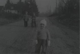
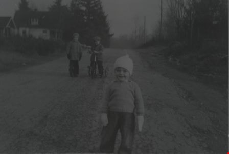
Lorne Auvache
https://search.heritageburnaby.ca/link/archivedescription37503
- Repository
- City of Burnaby Archives
- Date
- December 1940 (date of original), copied 1991
- Collection/Fonds
- Burnaby Historical Society fonds
- Description Level
- Item
- Physical Description
- 1 photograph : b&w ; 3.2 x 5.0 cm print on contact sheet 20.3 x 25.3 cm
- Scope and Content
- Photograph of Lorne Auvache wearing a hat and mittens on the 7200 block of Arcola Street. A young boy is on a tricycle, and another young boy is standing beside him in the background.
- Repository
- City of Burnaby Archives
- Date
- December 1940 (date of original), copied 1991
- Collection/Fonds
- Burnaby Historical Society fonds
- Subseries
- Burnaby Image Bank subseries
- Physical Description
- 1 photograph : b&w ; 3.2 x 5.0 cm print on contact sheet 20.3 x 25.3 cm
- Description Level
- Item
- Record No.
- 370-091
- Access Restriction
- No restrictions
- Reproduction Restriction
- No known restrictions
- Accession Number
- BHS1999-03
- Scope and Content
- Photograph of Lorne Auvache wearing a hat and mittens on the 7200 block of Arcola Street. A young boy is on a tricycle, and another young boy is standing beside him in the background.
- Names
- Auvache, Lorne
- Media Type
- Photograph
- Notes
- Title based on contents of photograph
- Piece missing from photograph on contact sheet
- 1 b&w copy negative accompanying
- Geographic Access
- Arcola Street
- Historic Neighbourhood
- Edmonds (Historic Neighbourhood)
- Planning Study Area
- Richmond Park Area
Images
![Lyle Le Grove with a baby carriage, [1943] (date of original), copied 1991 thumbnail](/media/hpo/_Data/_Archives_Images/_Unrestricted/370/370-618.jpg?width=280)
Lyle Le Grove with a baby carriage
https://search.heritageburnaby.ca/link/archivedescription38031
- Repository
- City of Burnaby Archives
- Date
- [1943] (date of original), copied 1991
- Collection/Fonds
- Burnaby Historical Society fonds
- Description Level
- Item
- Physical Description
- 1 photograph : b&w ; 3.6 x 2.7 cm print on contact sheet 20.6 x 26.3 cm
- Scope and Content
- Photograph Lyle Le Grove with a baby carriage, at 2224 Antrim Avenue (later renumbered as 6957 Antrim Avenue).
- Repository
- City of Burnaby Archives
- Date
- [1943] (date of original), copied 1991
- Collection/Fonds
- Burnaby Historical Society fonds
- Subseries
- Burnaby Image Bank subseries
- Physical Description
- 1 photograph : b&w ; 3.6 x 2.7 cm print on contact sheet 20.6 x 26.3 cm
- Description Level
- Item
- Record No.
- 370-618
- Access Restriction
- No restrictions
- Reproduction Restriction
- No known restrictions
- Accession Number
- BHS1999-03
- Scope and Content
- Photograph Lyle Le Grove with a baby carriage, at 2224 Antrim Avenue (later renumbered as 6957 Antrim Avenue).
- Media Type
- Photograph
- Notes
- Title based on contents of photograph
- 1 b&w copy negative accompanying
- Negative has a pink cast
- Geographic Access
- Antrim Avenue
- Street Address
- 6957 Antrim Avenue
- Historic Neighbourhood
- Central Park (Historic Neighbourhood)
- Planning Study Area
- Windsor Area
Images
![Lyle Le Grove with a baby carriage, [1943] (date of original), copied 1991 thumbnail](/media/hpo/_Data/_Archives_Images/_Unrestricted/370/370-618.jpg)
![Oxford Street, London, [1880] thumbnail](/media/hpo/_Data/_Archives_Images/_Unrestricted/477/477-762.jpg?width=280)
Oxford Street, London
https://search.heritageburnaby.ca/link/archivedescription39443
- Repository
- City of Burnaby Archives
- Date
- [1880]
- Collection/Fonds
- Peers Family and Hill Family fonds
- Description Level
- Item
- Physical Description
- 1 photograph : sepia ; 10.5 x 17.5 cm on page 21.5 x 28 cm (pasted in album)
- Scope and Content
- Photograph of Oxford Street in London. This photograph was in a scrapbook kept by Claude Hill who was originally from England but ultimately settled in the Burnaby Lake area.
- Repository
- City of Burnaby Archives
- Date
- [1880]
- Collection/Fonds
- Peers Family and Hill Family fonds
- Physical Description
- 1 photograph : sepia ; 10.5 x 17.5 cm on page 21.5 x 28 cm (pasted in album)
- Description Level
- Item
- Record No.
- 477-762
- Access Restriction
- No restrictions
- Reproduction Restriction
- No known restrictions
- Accession Number
- 2007-12
- Scope and Content
- Photograph of Oxford Street in London. This photograph was in a scrapbook kept by Claude Hill who was originally from England but ultimately settled in the Burnaby Lake area.
- Media Type
- Photograph
- Notes
- Title based on caption accompanying photograph
Images
![Oxford Street, London, [1880] thumbnail](/media/hpo/_Data/_Archives_Images/_Unrestricted/477/477-762.jpg)