More like '8357 Tenth Avenue, 8350 and 8353 Eleventh Avenue'
Narrow Results By
Decade
- 2020s 129
- 2010s 120
- 2000s 663
- 1990s 661
- 1980s 521
- 1970s 1170
- 1960s 377
- 1950s 544
- 1940s 602
- 1930s 604
- 1920s 657
- 1910s 655
- 1900s 277
- 1890s 36
- 1880s 70
- 1870s 5
- 1860s 3
- 1850s 1
- 1840s 1
- 1830s 1
- 1820s 1
- 1810s 1
- 1800s 1
- 1790s 1
- 1780s 1
- 1770s 1
- 1760s 1
- 1750s 1
- 1740s 1
- 1730s 1
- 1720s 1
- 1710s 1
- 1700s 1
- 1690s 1
- 1680s 1
- 1670s 1
- 1660s 1
- 1650s 1
- 1640s 1
- 1630s 1
- 1620s 1
- 1610s 1
- 1600s 1
Subject
- Accidents 1
- Accidents - Automobile Accidents 2
- Adornment 1
- Advertising Medium 4
- Advertising Medium - Signs and Signboards 127
- Aerial Photographs 59
- Agricultural Tools and Equipment 2
- Agricultural Tools and Equipment - Gardening Equipment 4
- Agricultural Tools and Equipment - Plows 5
- Agriculture 7
- Agriculture - Crops 2
- Agriculture - Dairy 1

Royal Crest Apartments
https://search.heritageburnaby.ca/link/archivedescription98680
- Repository
- City of Burnaby Archives
- Date
- 2022
- Collection/Fonds
- Disappearing Burnaby collection
- Description Level
- Item
- Physical Description
- 1 photograph (jpeg) : col.
- Scope and Content
- Photograph of the entrance and front path of Royal Crest Apartments, an apartment building located at 7165 Fulton Avenue. The building's exterior is stone and the path is bordered by an iron fence. The interior lobby is illuminated and visible through the glass door and windows, which feature the b…
- Repository
- City of Burnaby Archives
- Date
- 2022
- Collection/Fonds
- Disappearing Burnaby collection
- Physical Description
- 1 photograph (jpeg) : col.
- Description Level
- Item
- Record No.
- 634-027
- Access Restriction
- No restrictions
- Reproduction Restriction
- No restrictions
- Accession Number
- 2022-14
- Scope and Content
- Photograph of the entrance and front path of Royal Crest Apartments, an apartment building located at 7165 Fulton Avenue. The building's exterior is stone and the path is bordered by an iron fence. The interior lobby is illuminated and visible through the glass door and windows, which feature the building's name and a crest. The building was constructed in 1967.
- Media Type
- Photograph
- Photographer
- Cheung, Nakita
- Notes
- Title taken from the associated blog post
- Associated blog post: https://disappearingburnaby.wordpress.com/2022/06/30/royal-crest/
- Geographic Access
- Fulton Avenue
- Street Address
- 7165 Fulton Avenue
- Historic Neighbourhood
- Edmonds (Historic Neighbourhood)
- Planning Study Area
- Richmond Park Area
Images


Savoy Place
https://search.heritageburnaby.ca/link/archivedescription98668
- Repository
- City of Burnaby Archives
- Date
- 2022
- Collection/Fonds
- Disappearing Burnaby collection
- Description Level
- Item
- Physical Description
- 1 photograph (jpeg) : col.
- Scope and Content
- Photograph of the exterior of Savoy Place, an apartment complex located at 6355 Kingsway, at night. The building was constructed in 1968. Two people are standing in the illuminated lobby of the building, and wings of the building flank either side of the entrance, with trees and bushes lining the s…
- Repository
- City of Burnaby Archives
- Date
- 2022
- Collection/Fonds
- Disappearing Burnaby collection
- Physical Description
- 1 photograph (jpeg) : col.
- Description Level
- Item
- Record No.
- 634-015
- Access Restriction
- No restrictions
- Reproduction Restriction
- No restrictions
- Accession Number
- 2022-14
- Scope and Content
- Photograph of the exterior of Savoy Place, an apartment complex located at 6355 Kingsway, at night. The building was constructed in 1968. Two people are standing in the illuminated lobby of the building, and wings of the building flank either side of the entrance, with trees and bushes lining the sidewalk.
- Media Type
- Photograph
- Photographer
- Cheung, Nakita
- Notes
- Title taken from the associated blog post
- Associated blog post: https://disappearingburnaby.wordpress.com/2022/05/19/savoy-place/
- Geographic Access
- Kingsway
- Street Address
- 6355 Kingsway
- Historic Neighbourhood
- East Burnaby (Historic Neighbourhood)
- Planning Study Area
- Kingsway-Beresford Area
Images


Silver Star Apartments
https://search.heritageburnaby.ca/link/archivedescription98679
- Repository
- City of Burnaby Archives
- Date
- 2022
- Collection/Fonds
- Disappearing Burnaby collection
- Description Level
- Item
- Physical Description
- 1 photograph (jpeg) : col.
- Scope and Content
- Photograph of the exterior and lawn of Silver Star Apartments, a low-rise apartment building located at 6425 Silver Avenue. The building was constructed in 1970. The photograph is taken from across a lawn and several trees and bushes are partially obscuring the building. A high-rise tower is visibl…
- Repository
- City of Burnaby Archives
- Date
- 2022
- Collection/Fonds
- Disappearing Burnaby collection
- Physical Description
- 1 photograph (jpeg) : col.
- Description Level
- Item
- Record No.
- 634-026
- Access Restriction
- No restrictions
- Reproduction Restriction
- No restrictions
- Accession Number
- 2022-14
- Scope and Content
- Photograph of the exterior and lawn of Silver Star Apartments, a low-rise apartment building located at 6425 Silver Avenue. The building was constructed in 1970. The photograph is taken from across a lawn and several trees and bushes are partially obscuring the building. A high-rise tower is visible behind the apartment building.
- Media Type
- Photograph
- Photographer
- Cheung, Nakita
- Notes
- Title taken from the associated blog post
- Associated blog post: https://disappearingburnaby.wordpress.com/2022/06/30/silver-star-apartments/
- Geographic Access
- Silver Avenue
- Street Address
- 6425 Silver Avenue
- Historic Neighbourhood
- Central Park (Historic Neighbourhood)
- Planning Study Area
- Maywood Area
Images


Star Light Apartments
https://search.heritageburnaby.ca/link/archivedescription98676
- Repository
- City of Burnaby Archives
- Date
- 2022
- Collection/Fonds
- Disappearing Burnaby collection
- Description Level
- Item
- Physical Description
- 1 photograph (jpeg) : col.
- Scope and Content
- Photograph of the entrance to Star Light Apartments, a low-rise apartment building located at 6555 Telford Avenue. The entrance is covered by a second-floor balcony and the lights are on inside; the plant-filled lobby and a large mirror visible through the front windows. The building was constructe…
- Repository
- City of Burnaby Archives
- Date
- 2022
- Collection/Fonds
- Disappearing Burnaby collection
- Physical Description
- 1 photograph (jpeg) : col.
- Description Level
- Item
- Record No.
- 634-023
- Access Restriction
- No restrictions
- Reproduction Restriction
- No restrictions
- Accession Number
- 2022-14
- Scope and Content
- Photograph of the entrance to Star Light Apartments, a low-rise apartment building located at 6555 Telford Avenue. The entrance is covered by a second-floor balcony and the lights are on inside; the plant-filled lobby and a large mirror visible through the front windows. The building was constructed in 1964.
- Media Type
- Photograph
- Photographer
- Cheung, Nakita
- Notes
- Title taken from the associated blog post
- Associated blog post: https://disappearingburnaby.wordpress.com/2022/06/24/star-light-apartments/
- Geographic Access
- Telford Avenue
- Street Address
- 6555 Telford Avenue
- Historic Neighbourhood
- Central Park (Historic Neighbourhood)
- Planning Study Area
- Maywood Area
Images


Star Light Apartments sign
https://search.heritageburnaby.ca/link/archivedescription98677
- Repository
- City of Burnaby Archives
- Date
- 2022
- Collection/Fonds
- Disappearing Burnaby collection
- Description Level
- Item
- Physical Description
- 1 photograph (jpeg) : col.
- Scope and Content
- Photograph of the Blue Sky Investments Ltd.'s sign on the lawn of Star Light Apartments, a low-rise apartment building located at 6555 Telford Avenue. The building was constructed in 1964. The photograph depicts the scene at dusk; the building's entrance is visible to the left, with its exterior li…
- Repository
- City of Burnaby Archives
- Date
- 2022
- Collection/Fonds
- Disappearing Burnaby collection
- Physical Description
- 1 photograph (jpeg) : col.
- Description Level
- Item
- Record No.
- 634-024
- Access Restriction
- No restrictions
- Reproduction Restriction
- No restrictions
- Accession Number
- 2022-14
- Scope and Content
- Photograph of the Blue Sky Investments Ltd.'s sign on the lawn of Star Light Apartments, a low-rise apartment building located at 6555 Telford Avenue. The building was constructed in 1964. The photograph depicts the scene at dusk; the building's entrance is visible to the left, with its exterior lights on, and Telford Avenue and other neighbouring towers are visible in the background.
- Subjects
- Buildings - Residential
- Buildings - Residential - Apartments
- Advertising Medium - Signs and Signboards
- Media Type
- Photograph
- Photographer
- Cheung, Nakita
- Notes
- Title taken from the associated blog post
- Associated blog post: https://disappearingburnaby.wordpress.com/2022/06/24/star-light-apartments/
- Geographic Access
- Telford Avenue
- Street Address
- 6555 Telford Avenue
- Historic Neighbourhood
- Central Park (Historic Neighbourhood)
- Planning Study Area
- Marlborough Area
Images


Sussex Ave Apartment
https://search.heritageburnaby.ca/link/archivedescription98657
- Repository
- City of Burnaby Archives
- Date
- 2022
- Collection/Fonds
- Disappearing Burnaby collection
- Description Level
- Item
- Physical Description
- 1 photograph (jpeg) : col.
- Scope and Content
- Photograph of the exterior of Sussex Ave Apartment, an apartment building located at 6749 Sussex Avenue. The building was constructed in 1958. The photograph depicts a fire escape between two storeys; the blinds are drawn on the apartments' windows, and one has a light shining within the apartment.
- Repository
- City of Burnaby Archives
- Date
- 2022
- Collection/Fonds
- Disappearing Burnaby collection
- Physical Description
- 1 photograph (jpeg) : col.
- Description Level
- Item
- Record No.
- 634-004
- Access Restriction
- No restrictions
- Reproduction Restriction
- No restrictions
- Accession Number
- 2022-14
- Scope and Content
- Photograph of the exterior of Sussex Ave Apartment, an apartment building located at 6749 Sussex Avenue. The building was constructed in 1958. The photograph depicts a fire escape between two storeys; the blinds are drawn on the apartments' windows, and one has a light shining within the apartment.
- Media Type
- Photograph
- Photographer
- Cheung, Nakita
- Notes
- Title taken from the associated blog post
- Associated blog post: https://disappearingburnaby.wordpress.com/2022/02/01/sussex-ave-apartment/
- Geographic Access
- Sussex Avenue
- Street Address
- 6749 Sussex Avenue
- Historic Neighbourhood
- Central Park (Historic Neighbourhood)
- Planning Study Area
- Maywood Area
Images


Sussex Court
https://search.heritageburnaby.ca/link/archivedescription98658
- Repository
- City of Burnaby Archives
- Date
- 2022
- Collection/Fonds
- Disappearing Burnaby collection
- Description Level
- Item
- Physical Description
- 1 photograph (jpeg) : col.
- Scope and Content
- Photograph of the exterior of Sussex Court, an apartment building located at 6780 Sussex Avenue. The photograph depicts the entire building from across the street at dusk. The building was constructed in 1954. Lights are shining through the central stairwell and a few of the apartments' windows.
- Repository
- City of Burnaby Archives
- Date
- 2022
- Collection/Fonds
- Disappearing Burnaby collection
- Physical Description
- 1 photograph (jpeg) : col.
- Description Level
- Item
- Record No.
- 634-005
- Access Restriction
- No restrictions
- Reproduction Restriction
- No restrictions
- Accession Number
- 2022-14
- Scope and Content
- Photograph of the exterior of Sussex Court, an apartment building located at 6780 Sussex Avenue. The photograph depicts the entire building from across the street at dusk. The building was constructed in 1954. Lights are shining through the central stairwell and a few of the apartments' windows.
- Media Type
- Photograph
- Photographer
- Cheung, Nakita
- Notes
- Title taken from the associated blog post
- Associated blog post: https://disappearingburnaby.wordpress.com/2022/02/02/sussex-court/
- Geographic Access
- Sussex Avenue
- Street Address
- 6780 Sussex Avenue
- Historic Neighbourhood
- Central Park (Historic Neighbourhood)
- Planning Study Area
- Maywood Area
Images


Sussex Villa
https://search.heritageburnaby.ca/link/archivedescription98659
- Repository
- City of Burnaby Archives
- Date
- 2022
- Collection/Fonds
- Disappearing Burnaby collection
- Description Level
- Item
- Physical Description
- 1 photograph (jpeg) : col.
- Scope and Content
- Photograph of part of the exterior and front lawn of Sussex Villa, an apartment complex located at 6620-6630 Sussex Avenue, at night. The building was constructed in 1965 and is set to be developed into a high-rise tower by Keltic Canada Development. A light is on inside one of the apartment window…
- Repository
- City of Burnaby Archives
- Date
- 2022
- Collection/Fonds
- Disappearing Burnaby collection
- Physical Description
- 1 photograph (jpeg) : col.
- Description Level
- Item
- Record No.
- 634-006
- Access Restriction
- No restrictions
- Reproduction Restriction
- No restrictions
- Accession Number
- 2022-14
- Scope and Content
- Photograph of part of the exterior and front lawn of Sussex Villa, an apartment complex located at 6620-6630 Sussex Avenue, at night. The building was constructed in 1965 and is set to be developed into a high-rise tower by Keltic Canada Development. A light is on inside one of the apartment windows and a sign for the "Metrotown - Regional Town Centre Notification of Area Plan" stands on the lawn.
- Subjects
- Buildings - Residential - Apartments
- Buildings - Residential
- Advertising Medium - Signs and Signboards
- Planning - City Planning
- Media Type
- Photograph
- Photographer
- Cheung, Nakita
- Notes
- Title taken from the associated blog post
- Associated blog post: https://disappearingburnaby.wordpress.com/2022/01/29/sussex-villa-2/
- Geographic Access
- Sussex Avenue
- Street Address
- 6620 Sussex Avenue
- 6630 Sussex Avenue
- Historic Neighbourhood
- Central Park (Historic Neighbourhood)
- Planning Study Area
- Maywood Area
Images


Sussex Villa with sign
https://search.heritageburnaby.ca/link/archivedescription98660
- Repository
- City of Burnaby Archives
- Date
- 2022
- Collection/Fonds
- Disappearing Burnaby collection
- Description Level
- Item
- Physical Description
- 1 photograph (jpeg) : col.
- Scope and Content
- Photograph of part of the exterior and front lawn of Sussex Villa, an apartment complex located at 6620-6630 Sussex Avenue, at night. The building was constructed in 1965 and is set to be developed into a high-rise tower by Keltic Canada Development. A sign standing on the lawn reads: "Land Loan" a…
- Repository
- City of Burnaby Archives
- Date
- 2022
- Collection/Fonds
- Disappearing Burnaby collection
- Physical Description
- 1 photograph (jpeg) : col.
- Description Level
- Item
- Record No.
- 634-007
- Access Restriction
- No restrictions
- Reproduction Restriction
- No restrictions
- Accession Number
- 2022-14
- Scope and Content
- Photograph of part of the exterior and front lawn of Sussex Villa, an apartment complex located at 6620-6630 Sussex Avenue, at night. The building was constructed in 1965 and is set to be developed into a high-rise tower by Keltic Canada Development. A sign standing on the lawn reads: "Land Loan" and "Domain Funding" with contact information, and a residential tower is visible in the background.
- Subjects
- Buildings - Residential - Apartments
- Buildings - Residential
- Advertising Medium - Signs and Signboards
- Media Type
- Photograph
- Photographer
- Cheung, Nakita
- Notes
- Title taken from the associated blog post
- Associated blog post: https://disappearingburnaby.wordpress.com/2022/01/29/sussex-villa-2/
- Geographic Access
- Sussex Avenue
- Street Address
- 6620 Sussex Avenue
- 6630 Sussex Avenue
- Historic Neighbourhood
- Central Park (Historic Neighbourhood)
- Planning Study Area
- Maywood Area
Images


Three Apartment Blocks
https://search.heritageburnaby.ca/link/archivedescription64659
- Repository
- City of Burnaby Archives
- Date
- 1954
- Collection/Fonds
- Ernest Winch fonds
- Description Level
- Item
- Physical Description
- 1 photograph : b&w postcard ; 8 x 13 cm
- Scope and Content
- Photographic postcard of the three apartment blocks at New Vista Society's Senior Citizens Housing Project no. 6 at 141-149-155 11th Avenue (later renumbered the 8100 block of 11th Avenue).
- Repository
- City of Burnaby Archives
- Date
- 1954
- Collection/Fonds
- Ernest Winch fonds
- Physical Description
- 1 photograph : b&w postcard ; 8 x 13 cm
- Description Level
- Item
- Record No.
- 514-008
- Access Restriction
- No restrictions
- Reproduction Restriction
- Reproduce for fair dealing purposes only
- Accession Number
- 2010-06
- Scope and Content
- Photographic postcard of the three apartment blocks at New Vista Society's Senior Citizens Housing Project no. 6 at 141-149-155 11th Avenue (later renumbered the 8100 block of 11th Avenue).
- Names
- New Vista Society
- Media Type
- Photograph
- Notes
- Transcribed title
- Photographer's note on recto of photograph reads: "Three Apartment Blocks / Senior Citizens Housing Project # 6 / Burnaby - B.C. - 1954"
- Geographic Access
- 11th Avenue
- Historic Neighbourhood
- East Burnaby (Historic Neighbourhood)
- Planning Study Area
- Second Street Area
Images


Brookes family home, "Normanna"
https://search.heritageburnaby.ca/link/archivedescription35246
- Repository
- City of Burnaby Archives
- Date
- 1927
- Collection/Fonds
- Burnaby Historical Society fonds
- Description Level
- Item
- Physical Description
- 1 photograph : b&w ; 12.7 x 17.8 cm print
- Scope and Content
- Photograph of "Normanna," the Brookes family residence. This new Brookes family home was built in 1927 on the same site as the original house at 441 12th Avenue (later renumbered 7979 12th Avenue). Eventually, this became Normanna Norwegian rest home. The original house was built by Burnaby's firs…
- Repository
- City of Burnaby Archives
- Date
- 1927
- Collection/Fonds
- Burnaby Historical Society fonds
- Subseries
- Pioneer Tales subseries
- Physical Description
- 1 photograph : b&w ; 12.7 x 17.8 cm print
- Description Level
- Item
- Record No.
- 204-103
- Access Restriction
- No restrictions
- Reproduction Restriction
- No known restrictions
- Accession Number
- BHS1988-03
- Scope and Content
- Photograph of "Normanna," the Brookes family residence. This new Brookes family home was built in 1927 on the same site as the original house at 441 12th Avenue (later renumbered 7979 12th Avenue). Eventually, this became Normanna Norwegian rest home. The original house was built by Burnaby's first Reeve, Charles Shaw, and is now a designated heritage site at 7725 4th Street.
- Subjects
- Geographic Features - Gardens
- Buildings - Residential - Houses
- Buildings - Residential - Seniors Housing
- Buildings - Heritage
- Names
- Normanna Rest Home
- Media Type
- Photograph
- Notes
- Title based on contents of photograph
- Geographic Access
- 4th Street
- Street Address
- 7725 4th Street
- Historic Neighbourhood
- East Burnaby (Historic Neighbourhood)
- Planning Study Area
- Second Street Area
Images

![4042 Yale Street, [1961 or 1962] (date of original), copied 1991 thumbnail](/media/hpo/_Data/_Archives_Images/_Unrestricted/370/370-214.jpg?width=280)
4042 Yale Street
https://search.heritageburnaby.ca/link/archivedescription37626
- Repository
- City of Burnaby Archives
- Date
- [1961 or 1962] (date of original), copied 1991
- Collection/Fonds
- Burnaby Historical Society fonds
- Description Level
- Item
- Physical Description
- 1 photograph : b&w ; 3.9 x 3.9 cm print on contact sheet 20.2 x 25.3 cm
- Scope and Content
- Photograph from above 4042 Yale Street looking northeast. Burrard Inlet and the northshore mountains are visible in the background. The photograph was taken during the winter of 1961 to 1962, and there is snow.
- Repository
- City of Burnaby Archives
- Date
- [1961 or 1962] (date of original), copied 1991
- Collection/Fonds
- Burnaby Historical Society fonds
- Subseries
- Burnaby Image Bank subseries
- Physical Description
- 1 photograph : b&w ; 3.9 x 3.9 cm print on contact sheet 20.2 x 25.3 cm
- Description Level
- Item
- Record No.
- 370-214
- Access Restriction
- No restrictions
- Reproduction Restriction
- No restrictions
- Accession Number
- BHS1999-03
- Scope and Content
- Photograph from above 4042 Yale Street looking northeast. Burrard Inlet and the northshore mountains are visible in the background. The photograph was taken during the winter of 1961 to 1962, and there is snow.
- Subjects
- Buildings - Residential - Houses
- Geographic Features - Inlets
- Geographic Features - Mountains
- Media Type
- Photograph
- Notes
- Title based on contents of photograph
- 1 b&w copy negative accompanying
- Geographic Access
- Yale Street
- Street Address
- 4042 Yale Street
- Historic Neighbourhood
- Vancouver Heights (Historic Neighbourhood)
- Planning Study Area
- Burnaby Heights Area
Images
![4042 Yale Street, [1961 or 1962] (date of original), copied 1991 thumbnail](/media/hpo/_Data/_Archives_Images/_Unrestricted/370/370-214.jpg)
6088 Cassie Avenue
https://search.heritageburnaby.ca/link/archivedescription93717
- Repository
- City of Burnaby Archives
- Date
- 1987
- Collection/Fonds
- Grover, Elliott & Co. Ltd. fonds
- Description Level
- File
- Physical Description
- 14 photographs : col. negatives ; 35 mm + 5 photographs : col. ; 10 cm x 15 cm
- Scope and Content
- Photographs of the private residence and garden located at 6088 Cassie Avenue - an address that no longer exists.
- Repository
- City of Burnaby Archives
- Date
- 1987
- Collection/Fonds
- Grover, Elliott & Co. Ltd. fonds
- Physical Description
- 14 photographs : col. negatives ; 35 mm + 5 photographs : col. ; 10 cm x 15 cm
- Description Level
- File
- Record No.
- 622-006
- Access Restriction
- No restrictions
- Reproduction Restriction
- No restrictions
- Accession Number
- 2017-39
- Scope and Content
- Photographs of the private residence and garden located at 6088 Cassie Avenue - an address that no longer exists.
- Media Type
- Photograph
- Notes
- Transcribed title
- Title transcribed from original print envelope
- File no. 87-300-B
- Geographic Access
- Cassie Avenue
- Historic Neighbourhood
- Central Park (Historic Neighbourhood)
- Planning Study Area
- Maywood Area
7837 CA Way Burnaby
https://search.heritageburnaby.ca/link/archivedescription93813
- Repository
- City of Burnaby Archives
- Date
- November 1992
- Collection/Fonds
- Grover, Elliott & Co. Ltd. fonds
- Description Level
- File
- Physical Description
- 48 photographs : col. negatives ; 35 mm + 5 photographs : col. ; 10 cm x 15 cm
- Scope and Content
- Photographs of the residential buildings located at 7837 Canada Way. Buildings include a two-storey blue-shingled house, single-storey addition, and a guest house. File also contains photographs of the Capilano suspension bridge and Capilano Suspension Bridge Park in North Vancouver.
- Repository
- City of Burnaby Archives
- Date
- November 1992
- Collection/Fonds
- Grover, Elliott & Co. Ltd. fonds
- Physical Description
- 48 photographs : col. negatives ; 35 mm + 5 photographs : col. ; 10 cm x 15 cm
- Description Level
- File
- Record No.
- 622-061
- Access Restriction
- No restrictions
- Reproduction Restriction
- No restrictions
- Accession Number
- 2017-39
- Scope and Content
- Photographs of the residential buildings located at 7837 Canada Way. Buildings include a two-storey blue-shingled house, single-storey addition, and a guest house. File also contains photographs of the Capilano suspension bridge and Capilano Suspension Bridge Park in North Vancouver.
- Media Type
- Photograph
- Notes
- Transcribed title
- Title transcribed from envelope photographs were originally housed in
- File no. 92-437-B
- Sticky note adhered to 622-061-9 print reads: "7 / View of the building looking northeast across the site".
- Sticky note adhered to 622-061-13 print reads: "6 / View of the original house and the single storey addition looking north west across the property".
- Sticky note adhered to 622-061-17 print reads: "8 / View northeast across the property from the southeast corner".
- Sticky note adhered to 622-061-21 print reads: "9 / View west from the property along the lane at the south side".
- Sticky note adhered to 622-061-26 reads: "3 / The original house now part of the guest home and the view south along the east property line".
- Sticky note adhered to 622-061-27 reads: "4 / View west along Canada Way [illegible] the subject".
- Sticky note adhered to 622-061-28 reads: "5 / The most recent addition - the single storey L shaped structure at the west end of the guesthouse".
- Sticky note adhere to 622-061-29 reads: "5A / The original house"."
- Photographer identified as "D.E."
- Geographic Access
- Canada Way
- Street Address
- 7837 Canada Way
- Planning Study Area
- Lake City Area
9886 and 9940 Broadway
https://search.heritageburnaby.ca/link/archivedescription94331
- Repository
- City of Burnaby Archives
- Date
- March 1995
- Collection/Fonds
- Grover, Elliott & Co. Ltd. fonds
- Description Level
- File
- Physical Description
- 70 photographs : col. negatives ; 35 mm
- Scope and Content
- Photographs of Broadway, various residential houses and towers, and undeveloped properties at unidentified locations.
- Repository
- City of Burnaby Archives
- Date
- March 1995
- Collection/Fonds
- Grover, Elliott & Co. Ltd. fonds
- Physical Description
- 70 photographs : col. negatives ; 35 mm
- Description Level
- File
- Record No.
- 622-116
- Access Restriction
- No restrictions
- Reproduction Restriction
- No restrictions
- Accession Number
- 2017-39
- Scope and Content
- Photographs of Broadway, various residential houses and towers, and undeveloped properties at unidentified locations.
- Media Type
- Photograph
- Notes
- Transcribed title
- Title transcribed from envelope photographs were originally housed in
- File no. 95-069-B
- Photographer identified as "K.H."
- Geographic Access
- Broadway
- Street Address
- 9886 Broadway
- 9940 Broadway
- Historic Neighbourhood
- Burquitlam (Historic Neighbourhood)
- Planning Study Area
- Lyndhurst Area

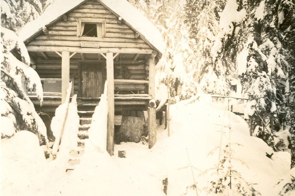
"Argu-In" cabin on Mount Seymour
https://search.heritageburnaby.ca/link/museumdescription2936
- Repository
- Burnaby Village Museum
- Date
- [between 1939 and 1949] (date of orignals), copied 2008
- Collection/Fonds
- Pixie McGeachie fonds
- Description Level
- Item
- Physical Description
- 1 photograph (tiff) : b&w ; 600 dpi
- Scope and Content
- Photograph of Jack and Pixie McGeachie's snow covered log cabin "Argu-In" looking down slope, through the trees on Mount Seymour, North Vancouver. Jack McGeachie and friends, Maurice Skinner and Jack Gannon built and maintained a cabin with friends on Mount Seymour from 1938 until after the Second…
- Repository
- Burnaby Village Museum
- Collection/Fonds
- Pixie McGeachie fonds
- Description Level
- Item
- Physical Description
- 1 photograph (tiff) : b&w ; 600 dpi
- Scope and Content
- Photograph of Jack and Pixie McGeachie's snow covered log cabin "Argu-In" looking down slope, through the trees on Mount Seymour, North Vancouver. Jack McGeachie and friends, Maurice Skinner and Jack Gannon built and maintained a cabin with friends on Mount Seymour from 1938 until after the Second World War.
- Subjects
- Natural Phenomena - Snow
- Geographic Features - Forests
- Geographic Features - Mountains - British Columbia
- Buildings - Residential - Cabins
- Accession Code
- BV008.17.25
- Access Restriction
- No restrictions
- Reproduction Restriction
- May be restricted by third party rights
- Date
- [between 1939 and 1949] (date of orignals), copied 2008
- Media Type
- Photograph
- Notes
- Title based on contents of photograph
Images


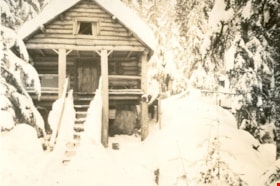
"Argu-In" on Mount Seymour
https://search.heritageburnaby.ca/link/museumdescription2923
- Repository
- Burnaby Village Museum
- Date
- [between 1939 and 1949] (date of orignals), copied 2008
- Collection/Fonds
- Pixie McGeachie fonds
- Description Level
- Item
- Physical Description
- 1 photograph (tiff) : b&w ; 600 dpi
- Scope and Content
- Photograph of Jack and Pixie McGeachie's log cabin, "Argu-In" located on Mount Seymour, North Vancouver. The cabin is surrounded by snow covered trees. Jack McGeachie and friends, Maurice Skinner and Jack Gannon built and maintained a cabin with friends on Mount Seymour from 1938 until after the …
- Repository
- Burnaby Village Museum
- Collection/Fonds
- Pixie McGeachie fonds
- Description Level
- Item
- Physical Description
- 1 photograph (tiff) : b&w ; 600 dpi
- Scope and Content
- Photograph of Jack and Pixie McGeachie's log cabin, "Argu-In" located on Mount Seymour, North Vancouver. The cabin is surrounded by snow covered trees. Jack McGeachie and friends, Maurice Skinner and Jack Gannon built and maintained a cabin with friends on Mount Seymour from 1938 until after the Second World War.
- Subjects
- Natural Phenomena - Snow
- Geographic Features - Forests
- Geographic Features - Mountains - British Columbia
- Buildings - Residential - Cabins
- Accession Code
- BV008.17.12
- Access Restriction
- No restrictions
- Reproduction Restriction
- May be restricted by third party rights
- Date
- [between 1939 and 1949] (date of orignals), copied 2008
- Media Type
- Photograph
- Notes
- Title based on contents of photograph
Images


"Argu-In" on Mount Seymour
https://search.heritageburnaby.ca/link/museumdescription2924
- Repository
- Burnaby Village Museum
- Date
- [between 1939 and 1949] (date of orignals), copied 2008
- Collection/Fonds
- Pixie McGeachie fonds
- Description Level
- Item
- Physical Description
- 1 photograph (tiff) : b&w ; 600 dpi
- Scope and Content
- Photograph of a side view of Jack and Pixie McGeachie's cabin "Argu-In" looking through snow covered trees on Mount Seymour, North Vancouver. The cabin was located on Mount Seymour.Jack McGeachie and friends, Maurice Skinner and Jack Gannon built and maintained a cabin with friends on Mount Seymou…
- Repository
- Burnaby Village Museum
- Collection/Fonds
- Pixie McGeachie fonds
- Description Level
- Item
- Physical Description
- 1 photograph (tiff) : b&w ; 600 dpi
- Scope and Content
- Photograph of a side view of Jack and Pixie McGeachie's cabin "Argu-In" looking through snow covered trees on Mount Seymour, North Vancouver. The cabin was located on Mount Seymour.Jack McGeachie and friends, Maurice Skinner and Jack Gannon built and maintained a cabin with friends on Mount Seymour from 1938 until after the Second World War.
- Subjects
- Natural Phenomena - Snow
- Geographic Features - Forests
- Geographic Features - Mountains - British Columbia
- Buildings - Residential - Cabins
- Accession Code
- BV008.17.13
- Access Restriction
- No restrictions
- Reproduction Restriction
- May be restricted by third party rights
- Date
- [between 1939 and 1949] (date of orignals), copied 2008
- Media Type
- Photograph
- Notes
- Title based on contents of photograph
Images


"Argu-In" on Mount Seymour
https://search.heritageburnaby.ca/link/museumdescription2925
- Repository
- Burnaby Village Museum
- Date
- [between 1939 and 1949] (date of orignals), copied 2008
- Collection/Fonds
- Pixie McGeachie fonds
- Description Level
- Item
- Physical Description
- 1 photograph (tiff) : b&w ; 600 dpi
- Scope and Content
- Photograph of a side view of Jack and Pixie McGeachie's log cabin "Argu-In" on Mount Seymour, North Vancouver. There is a bit of snow on the ground and smoke coming from the chimney. Jack McGeachie and friends, Maurice Skinner and Jack Gannon built and maintained a cabin with friends on Mount Seym…
- Repository
- Burnaby Village Museum
- Collection/Fonds
- Pixie McGeachie fonds
- Description Level
- Item
- Physical Description
- 1 photograph (tiff) : b&w ; 600 dpi
- Scope and Content
- Photograph of a side view of Jack and Pixie McGeachie's log cabin "Argu-In" on Mount Seymour, North Vancouver. There is a bit of snow on the ground and smoke coming from the chimney. Jack McGeachie and friends, Maurice Skinner and Jack Gannon built and maintained a cabin with friends on Mount Seymour from 1938 until after the Second World War.
- Subjects
- Natural Phenomena - Snow
- Geographic Features - Forests
- Geographic Features - Mountains - British Columbia
- Buildings - Residential - Cabins
- Accession Code
- BV008.17.14
- Access Restriction
- No restrictions
- Reproduction Restriction
- May be restricted by third party rights
- Date
- [between 1939 and 1949] (date of orignals), copied 2008
- Media Type
- Photograph
- Notes
- Title based on contents of photograph
Images

"Argu-In" on Mount Seymour
https://search.heritageburnaby.ca/link/museumdescription2937
- Repository
- Burnaby Village Museum
- Date
- [between 1939 and 1949] (date of orignals), copied 2008
- Collection/Fonds
- Pixie McGeachie fonds
- Description Level
- Item
- Physical Description
- 1 photograph (tiff) : b&w ; 600 dpi
- Scope and Content
- Photograph of Jack and Pixie McGeachie's of log cabin "Argu-In" surrounded by large drifts of snow. The cabin is located on Mount Seymour, North Vancouver. Jack McGeachie and friends, Maurice Skinner and Jack Gannon built and maintained a cabin with friends on Mount Seymour from 1938 until after th…
- Repository
- Burnaby Village Museum
- Collection/Fonds
- Pixie McGeachie fonds
- Description Level
- Item
- Physical Description
- 1 photograph (tiff) : b&w ; 600 dpi
- Scope and Content
- Photograph of Jack and Pixie McGeachie's of log cabin "Argu-In" surrounded by large drifts of snow. The cabin is located on Mount Seymour, North Vancouver. Jack McGeachie and friends, Maurice Skinner and Jack Gannon built and maintained a cabin with friends on Mount Seymour from 1938 until after the Second World War.
- Subjects
- Natural Phenomena - Snow
- Geographic Features - Forests
- Geographic Features - Mountains - British Columbia
- Buildings - Residential - Cabins
- Accession Code
- BV008.17.26
- Access Restriction
- No restrictions
- Reproduction Restriction
- May be restricted by third party rights
- Date
- [between 1939 and 1949] (date of orignals), copied 2008
- Media Type
- Photograph
- Notes
- Title based on contents of photograph
Images