More like 'Barnet Beach'
Narrow Results By
![Gaglardi Way pedestrian overpass, [2005] thumbnail](/media/hpo/_Data/_Archives_Images/_Unrestricted/535/535-1858.jpg?width=280)
Gaglardi Way pedestrian overpass
https://search.heritageburnaby.ca/link/archivedescription96161
- Repository
- City of Burnaby Archives
- Date
- [2005]
- Collection/Fonds
- Burnaby NewsLeader photograph collection
- Description Level
- Item
- Physical Description
- 1 photograph (tiff) : col.
- Scope and Content
- Photograph of Alex Nemeth posing next to his truck and the pedestrian overpass on Gaglardi Way.
- Repository
- City of Burnaby Archives
- Date
- [2005]
- Collection/Fonds
- Burnaby NewsLeader photograph collection
- Physical Description
- 1 photograph (tiff) : col.
- Description Level
- Item
- Record No.
- 535-1858
- Access Restriction
- No restrictions
- Reproduction Restriction
- No restrictions
- Accession Number
- 2018-12
- Scope and Content
- Photograph of Alex Nemeth posing next to his truck and the pedestrian overpass on Gaglardi Way.
- Media Type
- Photograph
- Photographer
- Bartel, Mario
- Notes
- Title based on caption
- Collected by editorial for use in a January 2005 issue of the Burnaby NewsLeader
- Caption from metadata: "The windshield on Alex Nemeth's pickup truck was smashed on Tuesday when kids dropped snowballs filled with rocks from the pedestrian overpass on Gagliardi Way in Burnaby as he passed underneath on his way to work. The City of Burnaby has promised to enclose the walkway."
- Geographic Access
- Gaglardi Way
Images
![Gaglardi Way pedestrian overpass, [2005] thumbnail](/media/hpo/_Data/_Archives_Images/_Unrestricted/535/535-1858.jpg)
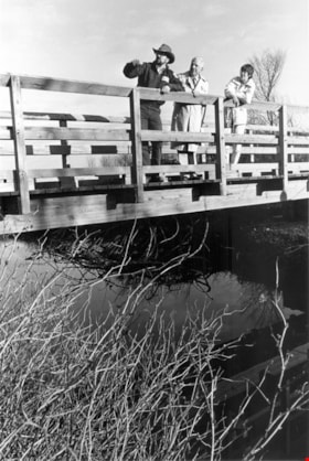
Liz Thurstrom, Bob Gardner, and Ken Elliot
https://search.heritageburnaby.ca/link/archivedescription78731
- Repository
- City of Burnaby Archives
- Date
- December 10, 1995
- Collection/Fonds
- Burnaby NewsLeader photograph collection
- Description Level
- Item
- Physical Description
- 1 photograph : b&w ; 23.5 x 16 cm
- Scope and Content
- Photograph of Liz Thurstrom, of the Wildlife Rescue Association of British Columbia, Bob Gardner, of the Burnaby Lake advisory council and Ken Elliot, of the Greater Vancouver Regional District (GVRD) atop the new footbridge completing the Burnaby Lake Trail.
- Repository
- City of Burnaby Archives
- Date
- December 10, 1995
- Collection/Fonds
- Burnaby NewsLeader photograph collection
- Physical Description
- 1 photograph : b&w ; 23.5 x 16 cm
- Description Level
- Item
- Record No.
- 535-0088
- Access Restriction
- No restrictions
- Reproduction Restriction
- No reproduction permitted
- Accession Number
- 2012-11
- Scope and Content
- Photograph of Liz Thurstrom, of the Wildlife Rescue Association of British Columbia, Bob Gardner, of the Burnaby Lake advisory council and Ken Elliot, of the Greater Vancouver Regional District (GVRD) atop the new footbridge completing the Burnaby Lake Trail.
- Media Type
- Photograph
- Photographer
- Bartel, Mario
- Notes
- Title based on contents of photograph
- Note in black and blue ink on recto of photograph reads: "3454 A Bby Mario / 95% Bby p.1"
- Trim marks and/or reproduction instructions on recto (scan is cropped)
- Geographic Access
- Burnaby Lake
Images

![Trans Canada Trail, [2000] thumbnail](/media/hpo/_Data/_Archives_Images/_Unrestricted/535/535-2372.jpg?width=280)
Trans Canada Trail
https://search.heritageburnaby.ca/link/archivedescription96814
- Repository
- City of Burnaby Archives
- Date
- [2000]
- Collection/Fonds
- Burnaby NewsLeader photograph collection
- Description Level
- Item
- Physical Description
- 1 photograph (tiff) : b&w
- Scope and Content
- Photograph of an unidentified person and their dog on the Trans Canada Trail in North Burnaby, overlooking the Burrard Inlet. Industrial ports and plants on the North Shore and the North Shore mountains are visible on the other side of the Inlet.
- Repository
- City of Burnaby Archives
- Date
- [2000]
- Collection/Fonds
- Burnaby NewsLeader photograph collection
- Physical Description
- 1 photograph (tiff) : b&w
- Description Level
- Item
- Record No.
- 535-2372
- Access Restriction
- No restrictions
- Reproduction Restriction
- No restrictions
- Accession Number
- 2018-12
- Scope and Content
- Photograph of an unidentified person and their dog on the Trans Canada Trail in North Burnaby, overlooking the Burrard Inlet. Industrial ports and plants on the North Shore and the North Shore mountains are visible on the other side of the Inlet.
- Media Type
- Photograph
- Photographer
- Bartel, Mario
- Notes
- Title based on caption
- Collected by editorial for use in an April 2000 issue of the Burnaby NewsLeader
- Caption from metadata: "The Trans Canada Trail is popular with dog walkers, offering spectacular vistas of Burrard Inlet and the North Shore Mountains."
- Geographic Access
- Burrard Inlet
- Historic Neighbourhood
- Capitol Hill (Historic Neighbourhood)
- Planning Study Area
- Capitol Hill Area
Images
![Trans Canada Trail, [2000] thumbnail](/media/hpo/_Data/_Archives_Images/_Unrestricted/535/535-2372.jpg)
![Doug Drummond at Barnet Marine Park, [2003] thumbnail](/media/hpo/_Data/_Archives_Images/_Unrestricted/535/535-2277-1.jpg?width=280)
Doug Drummond at Barnet Marine Park
https://search.heritageburnaby.ca/link/archivedescription96655
- Repository
- City of Burnaby Archives
- Date
- [2003]
- Collection/Fonds
- Burnaby NewsLeader photograph collection
- Description Level
- File
- Physical Description
- 2 photographs (tiff) : col.
- Scope and Content
- File contains photographs of former City of Burnaby mayor Doug Drummond at Barnet Marine Park before is improvement and expansion. Photographs depict Drummond standing by the Inlet and walking along the waterfront path with Parks Commissioner Dan Johnston.
- Repository
- City of Burnaby Archives
- Date
- [2003]
- Collection/Fonds
- Burnaby NewsLeader photograph collection
- Physical Description
- 2 photographs (tiff) : col.
- Description Level
- File
- Record No.
- 535-2277
- Access Restriction
- No restrictions
- Reproduction Restriction
- No restrictions
- Accession Number
- 2018-12
- Scope and Content
- File contains photographs of former City of Burnaby mayor Doug Drummond at Barnet Marine Park before is improvement and expansion. Photographs depict Drummond standing by the Inlet and walking along the waterfront path with Parks Commissioner Dan Johnston.
- Subjects
- Geographic Features - Inlets
- Geographic Features - Parks
- Officials - Mayors and Reeves
- Officials - Commissioners
- Media Type
- Photograph
- Photographer
- Bartel, Mario
- Notes
- Title based on caption
- Collected by editorial for use in a March 2003 issue of the Burnaby NewsLeader
- Caption from metadata for 535-2277-1: "Former Burnaby Mayor, Doug Drummond, takes in the view from Barnet Marine Park, which will be expanded to the west, and enhanced with an interpretive centre in the old public works building and a rebuilt wharf reaching into the Burrard Inlet. Improving the park was one of Drummond's goals during his term in office."
- Caption fro metadata for 535-2277-2: "Former Burnaby mayor, Doug Drummond, and the city's parks commissioner, Dan Johnston, stroll along the path at Barnet Marine Park. The park will be expanded to the west, and enhanced with a rebuilt wharf into Burrard Inlet and an interpretive centre in the old public works building. The plan for the park will be the realization of one of Drummond's goals during his term in office."
- Geographic Access
- Barnet Marine Park
- Burrard Inlet
- Historic Neighbourhood
- Barnet (Historic Neighbourhood)
- Planning Study Area
- Burnaby Mountain Area
Images
![Doug Drummond at Barnet Marine Park, [2003] thumbnail](/media/hpo/_Data/_Archives_Images/_Unrestricted/535/535-2277-1.jpg)
![Joseph Santos at Barnet Marine Park, [2001] thumbnail](/media/hpo/_Data/_Archives_Images/_Unrestricted/535/535-2587.jpg?width=280)
Joseph Santos at Barnet Marine Park
https://search.heritageburnaby.ca/link/archivedescription97059
- Repository
- City of Burnaby Archives
- Date
- [2001]
- Collection/Fonds
- Burnaby NewsLeader photograph collection
- Description Level
- Item
- Physical Description
- 1 photograph (tiff) : col.
- Scope and Content
- Photograph of Joseph Santos in a rain poncho, searching for sea worms on the shores of the Burrard Inlet at Barnet Marine Park. An unidentified person fishing off the pier is visible behind Santos.
- Repository
- City of Burnaby Archives
- Date
- [2001]
- Collection/Fonds
- Burnaby NewsLeader photograph collection
- Physical Description
- 1 photograph (tiff) : col.
- Description Level
- Item
- Record No.
- 535-2587
- Access Restriction
- No restrictions
- Reproduction Restriction
- No restrictions
- Accession Number
- 2018-12
- Scope and Content
- Photograph of Joseph Santos in a rain poncho, searching for sea worms on the shores of the Burrard Inlet at Barnet Marine Park. An unidentified person fishing off the pier is visible behind Santos.
- Media Type
- Photograph
- Photographer
- Bartel, Mario
- Notes
- Title based on caption
- Collected by editorial for use in a July 2001 issue of the Burnaby NewsLeader
- Caption from metadata: "Joseph Santos isn't deterred by the soggy weather as he searches for sea worms to be used as bait at a family fishing expedition at Barnet Marine Park."
- Geographic Access
- Barnet Marine Park
- Burrard Inlet
- Historic Neighbourhood
- Barnet (Historic Neighbourhood)
- Planning Study Area
- Burnaby Mountain Area
Images
![Joseph Santos at Barnet Marine Park, [2001] thumbnail](/media/hpo/_Data/_Archives_Images/_Unrestricted/535/535-2587.jpg)
![Trans Canada Trail in North Burnaby, [2000] thumbnail](/media/hpo/_Data/_Archives_Images/_Unrestricted/535/535-2117-1.jpg?width=280)
Trans Canada Trail in North Burnaby
https://search.heritageburnaby.ca/link/archivedescription96493
- Repository
- City of Burnaby Archives
- Date
- [2000]
- Collection/Fonds
- Burnaby NewsLeader photograph collection
- Description Level
- File
- Physical Description
- 2 photographs (tiff) : col.
- Scope and Content
- File contains photographs of Ruth Hardy, Anita Loy, and Trudy Mile walking the Trans Canada Trail in North Burnaby. Photographs depict them enjoying a view of the Burrard Inlet from the Heights Trail leg and walking past a trail marker that reads: "The Heights Trail."
- Repository
- City of Burnaby Archives
- Date
- [2000]
- Collection/Fonds
- Burnaby NewsLeader photograph collection
- Physical Description
- 2 photographs (tiff) : col.
- Description Level
- File
- Record No.
- 535-2117
- Access Restriction
- No restrictions
- Reproduction Restriction
- No restrictions
- Accession Number
- 2018-12
- Scope and Content
- File contains photographs of Ruth Hardy, Anita Loy, and Trudy Mile walking the Trans Canada Trail in North Burnaby. Photographs depict them enjoying a view of the Burrard Inlet from the Heights Trail leg and walking past a trail marker that reads: "The Heights Trail."
- Media Type
- Photograph
- Photographer
- Bartel, Mario
- Notes
- Title based on caption
- Collected by editorial for use in a March 2000 issue of the Burnaby NewsLeader
- Caption from metadata for 535-2117-1: "Ruth Hardy, Anita Loy and Trudy Mile enjoy some of the views along the Heights Trail leg of the Trans Canada Trail, as it winds along Burrard Inlet."
- Caption from metadata for 535-2117-2: "Ruth Hardy, Trudy Mile and Anita Loy get a little exercise along the Trans Canada Trail as it winds through North Burnaby."
- Geographic Access
- Burrard Inlet
- Burnaby Heights Park
- Historic Neighbourhood
- Vancouver Heights (Historic Neighbourhood)
- Planning Study Area
- Burnaby Heights Area
Images
![Trans Canada Trail in North Burnaby, [2000] thumbnail](/media/hpo/_Data/_Archives_Images/_Unrestricted/535/535-2117-1.jpg)
![Radio-controlled boating at Deer Lake, [2000] thumbnail](/media/hpo/_Data/_Archives_Images/_Unrestricted/535/535-2375.jpg?width=280)
Radio-controlled boating at Deer Lake
https://search.heritageburnaby.ca/link/archivedescription96817
- Repository
- City of Burnaby Archives
- Date
- [2000]
- Collection/Fonds
- Burnaby NewsLeader photograph collection
- Description Level
- Item
- Physical Description
- 1 photograph (tiff) : col.
- Scope and Content
- Photograph of Ray Cooper placing his radio-controlled trimaran boat into Deer Lake from a dock. Deer Lake Beach is visible in the background.
- Repository
- City of Burnaby Archives
- Date
- [2000]
- Collection/Fonds
- Burnaby NewsLeader photograph collection
- Physical Description
- 1 photograph (tiff) : col.
- Description Level
- Item
- Record No.
- 535-2375
- Access Restriction
- No restrictions
- Reproduction Restriction
- No restrictions
- Accession Number
- 2018-12
- Scope and Content
- Photograph of Ray Cooper placing his radio-controlled trimaran boat into Deer Lake from a dock. Deer Lake Beach is visible in the background.
- Subjects
- Geographic Features - Beaches
- Geographic Features - Lakes and Ponds
- Recreational Activities - Boating
- Media Type
- Photograph
- Photographer
- Bartel, Mario
- Notes
- Title based on caption
- Collected by editorial for use in an April 2000 issue of the Burnaby NewsLeader
- Caption from metadata: "Ray Cooper struggles to launch his 6-foot tall radio-controlled trimiran from the dock at Deer Lake."
- Geographic Access
- Deer Lake
- Deer Lake Park
- Historic Neighbourhood
- Burnaby Lake (Historic Neighbourhood)
- Planning Study Area
- Morley-Buckingham Area
Images
![Radio-controlled boating at Deer Lake, [2000] thumbnail](/media/hpo/_Data/_Archives_Images/_Unrestricted/535/535-2375.jpg)
![Harry Pride and Barnet townsite, [2004] thumbnail](/media/hpo/_Data/_Archives_Images/_Unrestricted/535/535-2056-1.jpg?width=280)
Harry Pride and Barnet townsite
https://search.heritageburnaby.ca/link/archivedescription96386
- Repository
- City of Burnaby Archives
- Date
- [2004]
- Collection/Fonds
- Burnaby NewsLeader photograph collection
- Description Level
- File
- Physical Description
- 3 photographs (tiff) : col.
- Scope and Content
- File contains photographs of Harry Pride at work on researching his book about Burnaby's Barnet townsite. Photographs depict Pride with Beatrice Woolsey-McMillan, a former resident of the community, on the shore of the Burrard Inlet, and Pride viewing historical photographs and one of the remaining…
- Repository
- City of Burnaby Archives
- Date
- [2004]
- Collection/Fonds
- Burnaby NewsLeader photograph collection
- Physical Description
- 3 photographs (tiff) : col.
- Description Level
- File
- Record No.
- 535-2056
- Access Restriction
- No restrictions
- Reproduction Restriction
- No restrictions
- Accession Number
- 2018-12
- Scope and Content
- File contains photographs of Harry Pride at work on researching his book about Burnaby's Barnet townsite. Photographs depict Pride with Beatrice Woolsey-McMillan, a former resident of the community, on the shore of the Burrard Inlet, and Pride viewing historical photographs and one of the remaining structures from the Barnet sawmill.
- Subjects
- Geographic Features - Inlets
- Buildings - Industrial - Saw Mills
- Buildings - Industrial - Mills
- Media Type
- Photograph
- Photographer
- Bartel, Mario
- Notes
- Title based on caption
- Collected by editorial for use in a March 2004 issue of the Burnaby NewsLeader
- Caption from metadata for 535-2056-1: "Harry Pride, who is working on a book about Burnaby's Barnet townsite, reminisces with Beatrice Woolsey-McMillan, who lived in the mill community along the Burrard Inlet from 1925-46."
- Caption from metadata for 535-2056-2: "Harry Pride sorts through some of the historical photos he's collected for a book he's working on about Burnaby's Barnet townsite, along the Burrard Inlet."
- Caption from metadata for 535-2056-3: "Harry Pride, who's working on a book about Burnaby's Barnet townsite, checks out one of the remaining structures from the sawmill that once bustled along the Burrard Inlet."
- Geographic Access
- Barnet Village
- Burrard Inlet
- Barnet Marine Park
- Historic Neighbourhood
- Barnet (Historic Neighbourhood)
- Planning Study Area
- Burnaby Mountain Area
Images
![Harry Pride and Barnet townsite, [2004] thumbnail](/media/hpo/_Data/_Archives_Images/_Unrestricted/535/535-2056-1.jpg)
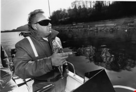
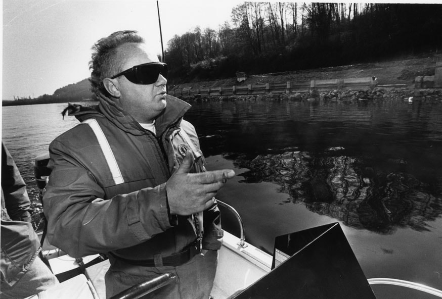
Rick Mehan
https://search.heritageburnaby.ca/link/archivedescription78908
- Repository
- City of Burnaby Archives
- Date
- March 10, 1996
- Collection/Fonds
- Burnaby NewsLeader photograph collection
- Description Level
- Item
- Physical Description
- 1 photograph : b&w ; 15.5 x 23 cm
- Scope and Content
- Photograph of Burnaby resident Rick Mehan in his boat along the Burrard Inlet.
- Repository
- City of Burnaby Archives
- Date
- March 10, 1996
- Collection/Fonds
- Burnaby NewsLeader photograph collection
- Physical Description
- 1 photograph : b&w ; 15.5 x 23 cm
- Description Level
- Item
- Record No.
- 535-0197
- Access Restriction
- No restrictions
- Reproduction Restriction
- No reproduction permitted
- Accession Number
- 2012-11
- Scope and Content
- Photograph of Burnaby resident Rick Mehan in his boat along the Burrard Inlet.
- Subjects
- Geographic Features - Inlets
- Names
- Mehan, Rick
- Media Type
- Photograph
- Photographer
- Bartel, Mario
- Notes
- Title based on contents of photograph
- Note in black ink on recto of photograph reads: "Bby Mario 605B"
- Scan is cropped
Images
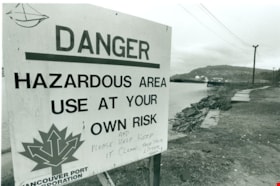
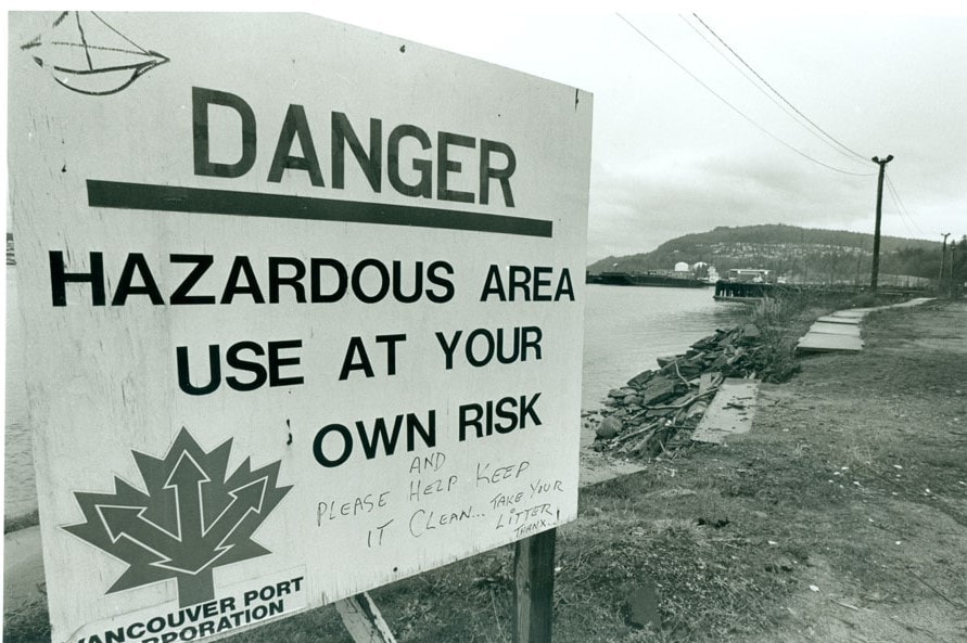
Sign at Berry Point
https://search.heritageburnaby.ca/link/archivedescription79448
- Repository
- City of Burnaby Archives
- Date
- August 11, 1996
- Collection/Fonds
- Burnaby NewsLeader photograph collection
- Description Level
- Item
- Physical Description
- 1 photograph : b&w ; 15.5 x 23 cm
- Scope and Content
- Photograph of a Vancouver Port Corporation sign at Berry Point that reads "Danger Hazardous Area Use At Your Own Risk". Additional hand writing on the sign "And please keep it clean... take your litter thanx...!"
- Repository
- City of Burnaby Archives
- Date
- August 11, 1996
- Collection/Fonds
- Burnaby NewsLeader photograph collection
- Physical Description
- 1 photograph : b&w ; 15.5 x 23 cm
- Description Level
- Item
- Record No.
- 535-0381
- Access Restriction
- No restrictions
- Reproduction Restriction
- No reproduction permitted
- Accession Number
- 2012-11
- Scope and Content
- Photograph of a Vancouver Port Corporation sign at Berry Point that reads "Danger Hazardous Area Use At Your Own Risk". Additional hand writing on the sign "And please keep it clean... take your litter thanx...!"
- Subjects
- Geographic Features - Inlets
- Media Type
- Photograph
- Photographer
- Bartel, Mario
- Notes
- Title based on contents of photograph
- Note in black ink on recto of photograph reads: "Bby 80 Mario File / 8/11 BNW"
- Trim marks and/or reproduction instructions on recto (scan is cropped)
Images

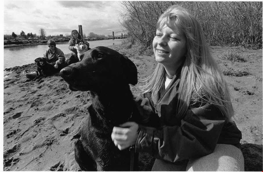
Foreshore Beach
https://search.heritageburnaby.ca/link/archivedescription80178
- Repository
- City of Burnaby Archives
- Date
- March 23, 1997
- Collection/Fonds
- Burnaby NewsLeader photograph collection
- Description Level
- Item
- Physical Description
- 1 photograph : b&w ; 15.5 x 23.5 cm
- Scope and Content
- Photograph of Sandy Curtis and her dog Gemma with friends, Judy Cooke with dog Molly and Cindy Gibbons with dog Shamus in the background at the foreshore park beach.
- Repository
- City of Burnaby Archives
- Date
- March 23, 1997
- Collection/Fonds
- Burnaby NewsLeader photograph collection
- Physical Description
- 1 photograph : b&w ; 15.5 x 23.5 cm
- Description Level
- Item
- Record No.
- 535-0666
- Access Restriction
- No restrictions
- Reproduction Restriction
- No reproduction permitted
- Accession Number
- 2012-11
- Scope and Content
- Photograph of Sandy Curtis and her dog Gemma with friends, Judy Cooke with dog Molly and Cindy Gibbons with dog Shamus in the background at the foreshore park beach.
- Media Type
- Photograph
- Photographer
- Bartel, Mario
- Notes
- Title based on contents of photograph
- Note in black ink on recto of photograph reads: "689 Bby Mario 58% Bby p. 8"
- Trim marks and/or reproduction instructions on recto (scan is cropped)
Images
![Shirley Fisher, [2000] thumbnail](/media/hpo/_Data/_Archives_Images/_Unrestricted/535/535-2109-1.jpg?width=280)
Shirley Fisher
https://search.heritageburnaby.ca/link/archivedescription96485
- Repository
- City of Burnaby Archives
- Date
- [2000]
- Collection/Fonds
- Burnaby NewsLeader photograph collection
- Description Level
- File
- Physical Description
- 2 photographs (tiff) : col.
- Scope and Content
- File contains photographs of Shirley Fisher, who formerly ran the boat rental concession at the Deer Lake Park beach, preparing to cycle across Canada. Photographs depict Fisher posing with her bicycle on the beach at Deer Lake and looking at a photograph album in the canoe rental shed at Deer Lake.
- Repository
- City of Burnaby Archives
- Date
- [2000]
- Collection/Fonds
- Burnaby NewsLeader photograph collection
- Physical Description
- 2 photographs (tiff) : col.
- Description Level
- File
- Record No.
- 535-2109
- Access Restriction
- No restrictions
- Reproduction Restriction
- No restrictions
- Accession Number
- 2018-12
- Scope and Content
- File contains photographs of Shirley Fisher, who formerly ran the boat rental concession at the Deer Lake Park beach, preparing to cycle across Canada. Photographs depict Fisher posing with her bicycle on the beach at Deer Lake and looking at a photograph album in the canoe rental shed at Deer Lake.
- Names
- Fisher, Shirley
- Media Type
- Photograph
- Photographer
- Bartel, Mario
- Notes
- Title based on caption
- Collected by editorial for use in a March 2000 issue of the Burnaby NewsLeader
- Caption from metadata for 535-2109-1: "Shirley Fisher is preparing to cycle across Canada, after retiring from her job running the boat rental concession at Deer Lake."
- Caption from metadata for 535-2109-2: "Shirley Fisher leafs through a photo album of memories of her years running the canoe rental shed at Deer Lake. She's retiring to pursue her dream of cycling across Canada."
- Geographic Access
- Deer Lake Park
- Deer Lake
- Historic Neighbourhood
- Burnaby Lake (Historic Neighbourhood)
- Planning Study Area
- Morley-Buckingham Area
Images
![Shirley Fisher, [2000] thumbnail](/media/hpo/_Data/_Archives_Images/_Unrestricted/535/535-2109-1.jpg)
![Rob Third and steel pedestrian overpass, [2006] thumbnail](/media/hpo/_Data/_Archives_Images/_Unrestricted/535/535-1902.jpg?width=280)
Rob Third and steel pedestrian overpass
https://search.heritageburnaby.ca/link/archivedescription96210
- Repository
- City of Burnaby Archives
- Date
- [2006]
- Collection/Fonds
- Burnaby NewsLeader photograph collection
- Description Level
- Item
- Physical Description
- 1 photograph (tiff) : col.
- Scope and Content
- Photograph of Rob Third, from steel fabrication plant George Third & Son, posing on the end of a steel pedestrian overpass that he just completed. The overpass will replace a concrete overpass over the Lougheed Highway in Coquitlam.
- Repository
- City of Burnaby Archives
- Date
- [2006]
- Collection/Fonds
- Burnaby NewsLeader photograph collection
- Physical Description
- 1 photograph (tiff) : col.
- Description Level
- Item
- Record No.
- 535-1902
- Access Restriction
- No restrictions
- Reproduction Restriction
- No restrictions
- Accession Number
- 2018-12
- Scope and Content
- Photograph of Rob Third, from steel fabrication plant George Third & Son, posing on the end of a steel pedestrian overpass that he just completed. The overpass will replace a concrete overpass over the Lougheed Highway in Coquitlam.
- Media Type
- Photograph
- Photographer
- Bartel, Mario
- Notes
- Title based on caption
- Collected by editorial for use in a February 2006 issue of the Burnaby NewsLeader
- Caption from metadata: "Rob Third is Burnaby's own Man of Steel. His steel fabrication plant, George Third & Son, has just completed work on a new pedestrian overpass to be installed over the Lougheed Highway in Coquitlam, replacing an old concrete one that was knocked down by a garbage truck last summer."
- Geographic Access
- Trapp Avenue
- Historic Neighbourhood
- Fraser Arm (Historic Neighbourhood)
- Planning Study Area
- Big Bend Area
Images
![Rob Third and steel pedestrian overpass, [2006] thumbnail](/media/hpo/_Data/_Archives_Images/_Unrestricted/535/535-1902.jpg)
![Bird watchers at Piper Pier, [2004] thumbnail](/media/hpo/_Data/_Archives_Images/_Unrestricted/535/535-1757.jpg?width=280)
Bird watchers at Piper Pier
https://search.heritageburnaby.ca/link/archivedescription96006
- Repository
- City of Burnaby Archives
- Date
- [2004]
- Collection/Fonds
- Burnaby NewsLeader photograph collection
- Description Level
- Item
- Physical Description
- 1 photograph (tiff) : col.
- Scope and Content
- Photograph of two bird watchers standing on Piper Pier in Burnaby Lake Regional Park. They are both looking into the distance with binoculars.
- Repository
- City of Burnaby Archives
- Date
- [2004]
- Collection/Fonds
- Burnaby NewsLeader photograph collection
- Physical Description
- 1 photograph (tiff) : col.
- Description Level
- Item
- Record No.
- 535-1757
- Access Restriction
- No restrictions
- Reproduction Restriction
- No restrictions
- Accession Number
- 2018-12
- Scope and Content
- Photograph of two bird watchers standing on Piper Pier in Burnaby Lake Regional Park. They are both looking into the distance with binoculars.
- Media Type
- Photograph
- Photographer
- Bartel, Mario
- Notes
- Title based on caption
- Collected by editorial for use in a January 2004 issue of the Burnaby NewsLeader
- Caption from metadata: "Juliet and Martin Mohlmann say they come down to Piper Pier at Burnaby Lake Regional Park to watch birds about twice a month. But they won't be able to use the pier in the late summer, as the GVRD, the Burnaby Rotary Club and Terasen will be spending $115,000 to rebuild it."
- Geographic Access
- Burnaby Lake Regional Nature Park
- Burnaby Lake
- Historic Neighbourhood
- Burnaby Lake (Historic Neighbourhood)
- Planning Study Area
- Burnaby Lake Area
Images
![Bird watchers at Piper Pier, [2004] thumbnail](/media/hpo/_Data/_Archives_Images/_Unrestricted/535/535-1757.jpg)
![Cariboo Dam fish weir, [2002] thumbnail](/media/hpo/_Data/_Archives_Images/_Unrestricted/535/535-2996.jpg?width=280)
Cariboo Dam fish weir
https://search.heritageburnaby.ca/link/archivedescription97722
- Repository
- City of Burnaby Archives
- Date
- [2002]
- Collection/Fonds
- Burnaby NewsLeader photograph collection
- Description Level
- Item
- Physical Description
- 1 photograph (tiff) : col.
- Scope and Content
- Photograph of Elmer Rudolph and Bob Henderson helping a salmon through the fish weir at the Cariboo Dam on the Brunette River.
- Repository
- City of Burnaby Archives
- Date
- [2002]
- Collection/Fonds
- Burnaby NewsLeader photograph collection
- Physical Description
- 1 photograph (tiff) : col.
- Description Level
- Item
- Record No.
- 535-2996
- Access Restriction
- No restrictions
- Reproduction Restriction
- No restrictions
- Accession Number
- 2018-12
- Scope and Content
- Photograph of Elmer Rudolph and Bob Henderson helping a salmon through the fish weir at the Cariboo Dam on the Brunette River.
- Media Type
- Photograph
- Photographer
- Bartel, Mario
- Notes
- Title based on caption
- Collected by editorial for use in a November 2002 issue of the Burnaby NewsLeader
- Caption from metadata: "Elmer Rudolph and Bob Henderson help a mature female salmon, weighing about nine pounds, up through the fish weir at the Cariboo dam. The week of heavy rain has finally made conditions favorable for fish to make their journey up the Brunette River from the Fraser, and then on to their spawning beds, and Rudolph is at the dam every day to help them along. On Saturday, in addition to the mature salmon, he also helped four immature males and two 14-inch Cutthroat."
- Geographic Access
- Burnaby Lake
- Brunette River
- Historic Neighbourhood
- Burnaby Lake (Historic Neighbourhood)
- Planning Study Area
- Burnaby Lake Area
Images
![Cariboo Dam fish weir, [2002] thumbnail](/media/hpo/_Data/_Archives_Images/_Unrestricted/535/535-2996.jpg)
![Burnaby creek conservationists, [2002] thumbnail](/media/hpo/_Data/_Archives_Images/_Unrestricted/535/535-1959-1.jpg?width=280)
Burnaby creek conservationists
https://search.heritageburnaby.ca/link/archivedescription96276
- Repository
- City of Burnaby Archives
- Date
- [2002]
- Collection/Fonds
- Burnaby NewsLeader photograph collection
- Description Level
- File
- Physical Description
- 4 photographs (tiff) : col.
- Scope and Content
- File contains photographs of volunteer conservationists with the Eagle Creek Streamkeepers, Byrne Creek Streamkeepers, and Sapperton Fish & Game Club at work in the Lake City area by Eagle Creek and the Brunette River. Photographs depict Nick Kvenich, of the Eagle Creek Streamkeepers, in a creek; m…
- Repository
- City of Burnaby Archives
- Date
- [2002]
- Collection/Fonds
- Burnaby NewsLeader photograph collection
- Physical Description
- 4 photographs (tiff) : col.
- Description Level
- File
- Record No.
- 535-1959
- Access Restriction
- No restrictions
- Reproduction Restriction
- No restrictions
- Accession Number
- 2018-12
- Scope and Content
- File contains photographs of volunteer conservationists with the Eagle Creek Streamkeepers, Byrne Creek Streamkeepers, and Sapperton Fish & Game Club at work in the Lake City area by Eagle Creek and the Brunette River. Photographs depict Nick Kvenich, of the Eagle Creek Streamkeepers, in a creek; members of the Byrne Creek Streamkeepers observing a storm drain; and Elmer Rudolf feeding fish at a Sapperton Fish & Game Club hatchery.
- Subjects
- Geographic Features - Creeks
- Geographic Features - Lakes and Ponds
- Geographic Features - Ravines
- Geographic Features - Streams
- Media Type
- Photograph
- Photographer
- Bartel, Mario
- Notes
- Title based on caption
- Collected by editorial for use in a March 2002 issue of the Burnaby NewsLeader
- Caption from metadata for 535-1959-1: "Nick Kvenich is one of the founding members of the Eagle Creek Streamkeepers, which is looking to preserve the habitat of the creek that runs down from Squint Lake into a ravine below the Lake City industrial area."
- Caption from metadata for 535-1959-2: "Joan Carne (r) and Louise Towell, of the Byrne Creek Streamkeepers, examine a storm drain in an industrial area above the creek. The habitat faces constant pressure from businesses and homeowners who pour solvents, soaps and substances into the drains without thought to the consequences."
- Caption from metadata for 535-1959-3: "Nick Kvenich, one of the founding members of the Eagle Creek Streamkeepers, climbs through a fallen tree that is blocking a trail that runs alongside the creek, in a ravine below the Lake City industrial area. Although the tree will eventually be cleared by the GVRD, Kvenich says he prefers if such obstacles be left alone, as they would discourage people who might abuse the habitat."
- Caption from metadata for 535-1959-4: "Elmer Rudolf feeds a new batch of coho fry at the Sapperton Fish & Game Club's hatchery, near the Brunette River. The fry are normally fed by a timed conveyor belt, but that is supplemented by hand feedings to give the weaker fish a chance."
- Geographic Access
- Brunette River
- Eagle Creek
- Planning Study Area
- Lake City Area
Images
![Burnaby creek conservationists, [2002] thumbnail](/media/hpo/_Data/_Archives_Images/_Unrestricted/535/535-1959-1.jpg)
![Burnaby rivers, [2002] thumbnail](/media/hpo/_Data/_Archives_Images/_Unrestricted/535/535-2800-1.jpg?width=280)
Burnaby rivers
https://search.heritageburnaby.ca/link/archivedescription97440
- Repository
- City of Burnaby Archives
- Date
- [2002]
- Collection/Fonds
- Burnaby NewsLeader photograph collection
- Description Level
- File
- Physical Description
- 4 photographs (tiff) : col.
- Scope and Content
- File contains photographs of people with Burnaby rivers and creeks. Photographs depict BCIT river conservationist Mark Angelo posing in Deer Lake Brook by Burnaby Village Museum, and Lorna Johnson, Gordie Cook, and Jack McAfee enjoying Fraser Foreshore Park by the Fraser River.
- Repository
- City of Burnaby Archives
- Date
- [2002]
- Collection/Fonds
- Burnaby NewsLeader photograph collection
- Physical Description
- 4 photographs (tiff) : col.
- Description Level
- File
- Record No.
- 535-2800
- Access Restriction
- No restrictions
- Reproduction Restriction
- No restrictions
- Accession Number
- 2018-12
- Scope and Content
- File contains photographs of people with Burnaby rivers and creeks. Photographs depict BCIT river conservationist Mark Angelo posing in Deer Lake Brook by Burnaby Village Museum, and Lorna Johnson, Gordie Cook, and Jack McAfee enjoying Fraser Foreshore Park by the Fraser River.
- Media Type
- Photograph
- Photographer
- Bartel, Mario
- Notes
- Title based on caption
- Collected by editorial for use in a September 2002 issue of the Burnaby NewsLeader
- Caption from metadata for 535-2800-1 and 535-2800-2: "Mark Angelo, of BCIT, who's made it his mission to save and preserve Burnaby's rivers and creeks, says he's particularly proud of Deer Lake Brook, as it babbles through Burnaby Village Museum, on its way to Burnaby Lake."
- Caption from metadata for 535-2800-3: "Lorna Johnson hits a tennis ball out into the Fraser River at Fraser Foreshore Park, to her dog, Keiko."
- Caption from metadata for 535-2800-4: "Gordie Cook and Jack McAfee shoot the breeze and enjoy the sunshine along the Fraser River, at Fraser Foreshore Park in Burnaby."
- Geographic Access
- Deer Lake Brook
- Burnaby Fraser Foreshore Park
- Fraser River
- Historic Neighbourhood
- Fraser Arm (Historic Neighbourhood)
- Burnaby Lake (Historic Neighbourhood)
- Planning Study Area
- Morley-Buckingham Area
- Big Bend Area
Images
![Burnaby rivers, [2002] thumbnail](/media/hpo/_Data/_Archives_Images/_Unrestricted/535/535-2800-1.jpg)
![Byrne Creek Streamkeepers, [2001] thumbnail](/media/hpo/_Data/_Archives_Images/_Unrestricted/535/535-2194-1.jpg?width=280)
Byrne Creek Streamkeepers
https://search.heritageburnaby.ca/link/archivedescription96572
- Repository
- City of Burnaby Archives
- Date
- [2001]
- Collection/Fonds
- Burnaby NewsLeader photograph collection
- Description Level
- File
- Physical Description
- 2 photographs (tiff) : col.
- Scope and Content
- File contains members of the Byrne Creek Streamkeepers during their work to protect the waterways and salmon in the area. Photographs depict Bob Fuller checking a waterflow measuring gauge and Joan Carne standing in the overflow channel at the salmon rearing ponds below Marine Drive.
- Repository
- City of Burnaby Archives
- Date
- [2001]
- Collection/Fonds
- Burnaby NewsLeader photograph collection
- Physical Description
- 2 photographs (tiff) : col.
- Description Level
- File
- Record No.
- 535-2194
- Access Restriction
- No restrictions
- Reproduction Restriction
- No restrictions
- Accession Number
- 2018-12
- Scope and Content
- File contains members of the Byrne Creek Streamkeepers during their work to protect the waterways and salmon in the area. Photographs depict Bob Fuller checking a waterflow measuring gauge and Joan Carne standing in the overflow channel at the salmon rearing ponds below Marine Drive.
- Subjects
- Persons - Volunteers
- Geographic Features - Creeks
- Geographic Features - Lakes and Ponds
- Geographic Features - Streams
- Media Type
- Photograph
- Photographer
- Bartel, Mario
- Notes
- Title based on caption
- Collected by editorial for use in a March 2001 issue of the Burnaby NewsLeader
- Caption from metadata for 535-2194-1: "Bob Fuller, of the Byrne Creek Streamkeepers, checks the guage that measures the flow of water which is released from the holding pond below Marine Drive to the salmon spawning beds downstream."
- Caption from metadata for 535-2194-2: "Joan Carne of the Byrne Creek Streamkeepers stands in the overflow channel at the salmon rearing ponds below Marine Drive. Although last week's chemical spill into Byrne Creek didn't reach the ponds, Carne says it's a constant battle to educate people to take care of the area's creeks and streams."
- Geographic Access
- Marine Drive
- Byrne Creek
- Planning Study Area
- Stride Hill Area
Images
![Byrne Creek Streamkeepers, [2001] thumbnail](/media/hpo/_Data/_Archives_Images/_Unrestricted/535/535-2194-1.jpg)
![Anthony Ferrari tree planting in Beecher Park, [2002] thumbnail](/media/hpo/_Data/_Archives_Images/_Unrestricted/535/535-2842.jpg?width=280)
Anthony Ferrari tree planting in Beecher Park
https://search.heritageburnaby.ca/link/archivedescription97503
- Repository
- City of Burnaby Archives
- Date
- [2002]
- Collection/Fonds
- Burnaby NewsLeader photograph collection
- Description Level
- Item
- Physical Description
- 1 photograph (tiff) : col.
- Scope and Content
- Photograph of Anthony Ferrari, an athlete with the Burnaby Winter Club AAA Bantams hockey team, planting vegetation during an environmental event with the Toronto Dominion Bank in Beecher Park.
- Repository
- City of Burnaby Archives
- Date
- [2002]
- Collection/Fonds
- Burnaby NewsLeader photograph collection
- Physical Description
- 1 photograph (tiff) : col.
- Description Level
- Item
- Record No.
- 535-2842
- Access Restriction
- No restrictions
- Reproduction Restriction
- No restrictions
- Accession Number
- 2018-12
- Scope and Content
- Photograph of Anthony Ferrari, an athlete with the Burnaby Winter Club AAA Bantams hockey team, planting vegetation during an environmental event with the Toronto Dominion Bank in Beecher Park.
- Subjects
- Persons - Athletes
- Environmental Issues
- Geographic Features - Creeks
- Geographic Features - Forests
- Names
- Burnaby Winter Club
- Media Type
- Photograph
- Photographer
- Bartel, Mario
- Notes
- Title based on caption
- Collected by editorial for use in a November 2002 issue of the Burnaby NewsLeader
- Caption from metadata: "Anthony Ferrari , a player with the Burnaby Winter Club AAA Bantams, does his part to help restore the natural habitat around Beecher Creek. Members of the team joined staff from the Toronto Dominion Bank Saturday to plant trees and native vegetation in the ongoing effort to maintain the creek as a home for fish as it passes through Beecher Park."
- Geographic Access
- Beecher Park
- Springer Avenue
- Street Address
- 1255 Springer Avenue
- Planning Study Area
- Brentwood Area
Images
![Anthony Ferrari tree planting in Beecher Park, [2002] thumbnail](/media/hpo/_Data/_Archives_Images/_Unrestricted/535/535-2842.jpg)
![Central Park snow, [2001] thumbnail](/media/hpo/_Data/_Archives_Images/_Unrestricted/535/535-1626.jpg?width=280)
Central Park snow
https://search.heritageburnaby.ca/link/archivedescription95794
- Repository
- City of Burnaby Archives
- Date
- [2001]
- Collection/Fonds
- Burnaby NewsLeader photograph collection
- Description Level
- Item
- Physical Description
- 1 photograph (tiff) : col.
- Scope and Content
- Photograph of two people dressed in winter clothing in Central Park. They are walking down a snow-covered path by the pond; it is snowing and the trees and ground are covered in snow. Many ducks are visible in the pond.
- Repository
- City of Burnaby Archives
- Date
- [2001]
- Collection/Fonds
- Burnaby NewsLeader photograph collection
- Physical Description
- 1 photograph (tiff) : col.
- Description Level
- Item
- Record No.
- 535-1626
- Access Restriction
- No restrictions
- Reproduction Restriction
- No restrictions
- Accession Number
- 2018-12
- Scope and Content
- Photograph of two people dressed in winter clothing in Central Park. They are walking down a snow-covered path by the pond; it is snowing and the trees and ground are covered in snow. Many ducks are visible in the pond.
- Media Type
- Photograph
- Photographer
- Bartel, Mario
- Notes
- Title based on caption
- Collected by editorial for use in a February 2001 issue of the Burnaby NewsLeader
- Caption from metadata: "Thursday's snowfall creates a winter wonderland around the duck pond in Burnaby's Central Park."
- Geographic Access
- Central Park
- Imperial Street
- Street Address
- 3883 Imperial Street
- Historic Neighbourhood
- Central Park (Historic Neighbourhood)
- Planning Study Area
- Maywood Area
Images
![Central Park snow, [2001] thumbnail](/media/hpo/_Data/_Archives_Images/_Unrestricted/535/535-1626.jpg)