More like 'Burnaby Central - North - N. Shore Mtns.'
Narrow Results By
Subject
- Accidents - Automobile Accidents 2
- Advertising Medium 3
- Advertising Medium - Signs and Signboards 97
- Aerial Photographs 56
- Agricultural Tools and Equipment 2
- Agricultural Tools and Equipment - Gardening Equipment 4
- Agricultural Tools and Equipment - Plows 5
- Agriculture 4
- Agriculture - Crops 2
- Agriculture - Farms 55
- Agriculture - Fruit and Berries 7
- Agriculture - Poultry 4
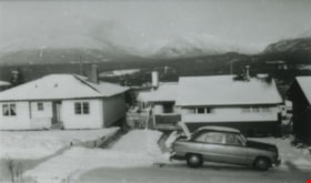
![4042 Yale Street, [1961 or 1962] (date of original), copied 1991 thumbnail](/media/hpo/_Data/_Archives_Images/_Unrestricted/370/370-214.jpg?width=280)
4042 Yale Street
https://search.heritageburnaby.ca/link/archivedescription37626
- Repository
- City of Burnaby Archives
- Date
- [1961 or 1962] (date of original), copied 1991
- Collection/Fonds
- Burnaby Historical Society fonds
- Description Level
- Item
- Physical Description
- 1 photograph : b&w ; 3.9 x 3.9 cm print on contact sheet 20.2 x 25.3 cm
- Scope and Content
- Photograph from above 4042 Yale Street looking northeast. Burrard Inlet and the northshore mountains are visible in the background. The photograph was taken during the winter of 1961 to 1962, and there is snow.
- Repository
- City of Burnaby Archives
- Date
- [1961 or 1962] (date of original), copied 1991
- Collection/Fonds
- Burnaby Historical Society fonds
- Subseries
- Burnaby Image Bank subseries
- Physical Description
- 1 photograph : b&w ; 3.9 x 3.9 cm print on contact sheet 20.2 x 25.3 cm
- Description Level
- Item
- Record No.
- 370-214
- Access Restriction
- No restrictions
- Reproduction Restriction
- No restrictions
- Accession Number
- BHS1999-03
- Scope and Content
- Photograph from above 4042 Yale Street looking northeast. Burrard Inlet and the northshore mountains are visible in the background. The photograph was taken during the winter of 1961 to 1962, and there is snow.
- Subjects
- Buildings - Residential - Houses
- Geographic Features - Inlets
- Geographic Features - Mountains
- Media Type
- Photograph
- Notes
- Title based on contents of photograph
- 1 b&w copy negative accompanying
- Geographic Access
- Yale Street
- Street Address
- 4042 Yale Street
- Historic Neighbourhood
- Vancouver Heights (Historic Neighbourhood)
- Planning Study Area
- Burnaby Heights Area
Images
![4042 Yale Street, [1961 or 1962] (date of original), copied 1991 thumbnail](/media/hpo/_Data/_Archives_Images/_Unrestricted/370/370-214.jpg)

From 4042 Yale Street
https://search.heritageburnaby.ca/link/archivedescription37628
- Repository
- City of Burnaby Archives
- Date
- 1952 (date of original), copied 1991
- Collection/Fonds
- Burnaby Historical Society fonds
- Description Level
- Item
- Physical Description
- 1 photograph : b&w ; 2.9 x 4.8 cm print on contact sheet 20.2 x 25.3 cm
- Scope and Content
- Photograph taken looking north from 4042 Yale Street. Burrard Inlet and the northshore mountains are visible in the background, and there is snow.
- Repository
- City of Burnaby Archives
- Date
- 1952 (date of original), copied 1991
- Collection/Fonds
- Burnaby Historical Society fonds
- Subseries
- Burnaby Image Bank subseries
- Physical Description
- 1 photograph : b&w ; 2.9 x 4.8 cm print on contact sheet 20.2 x 25.3 cm
- Description Level
- Item
- Record No.
- 370-216
- Access Restriction
- No restrictions
- Reproduction Restriction
- No restrictions
- Accession Number
- BHS1999-03
- Scope and Content
- Photograph taken looking north from 4042 Yale Street. Burrard Inlet and the northshore mountains are visible in the background, and there is snow.
- Subjects
- Buildings - Residential - Houses
- Geographic Features - Inlets
- Geographic Features - Mountains
- Media Type
- Photograph
- Notes
- Title based on contents of photograph
- 1 b&w copy negative accompanying
- Geographic Access
- Yale Street
- Street Address
- 4042 Yale Street
- Historic Neighbourhood
- Vancouver Heights (Historic Neighbourhood)
- Planning Study Area
- Burnaby Heights Area
Images

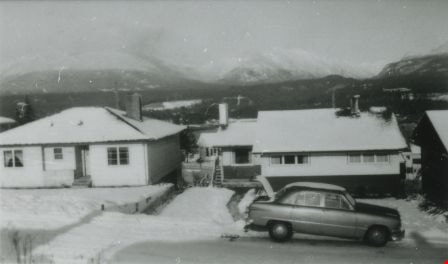
![4042 Yale Street, [1961 or 1962] (date of original), copied 1991 thumbnail](/media/hpo/_Data/_Archives_Images/_Unrestricted/370/370-213.jpg?width=280)
4042 Yale Street
https://search.heritageburnaby.ca/link/archivedescription37625
- Repository
- City of Burnaby Archives
- Date
- [1961 or 1962] (date of original), copied 1991
- Collection/Fonds
- Burnaby Historical Society fonds
- Description Level
- Item
- Physical Description
- 1 photograph : b&w ; 3.9 x 3.9 cm print on contact sheet 20.2 x 25.3 cm
- Scope and Content
- Photograph of 4042 Yale Street, taken from behind and above the house. The photograph was taken facing north, with the north shore mountains visible in the background. The photograph was taken during the winter of 1961 to 1962, and there is snow.
- Repository
- City of Burnaby Archives
- Date
- [1961 or 1962] (date of original), copied 1991
- Collection/Fonds
- Burnaby Historical Society fonds
- Subseries
- Burnaby Image Bank subseries
- Physical Description
- 1 photograph : b&w ; 3.9 x 3.9 cm print on contact sheet 20.2 x 25.3 cm
- Description Level
- Item
- Record No.
- 370-213
- Access Restriction
- No restrictions
- Reproduction Restriction
- No restrictions
- Accession Number
- BHS1999-03
- Scope and Content
- Photograph of 4042 Yale Street, taken from behind and above the house. The photograph was taken facing north, with the north shore mountains visible in the background. The photograph was taken during the winter of 1961 to 1962, and there is snow.
- Media Type
- Photograph
- Notes
- Title based on contents of photograph
- 1 b&w copy negative accompanying
- Geographic Access
- Yale Street
- Street Address
- 4042 Yale Street
- Historic Neighbourhood
- Vancouver Heights (Historic Neighbourhood)
- Planning Study Area
- Burnaby Heights Area
Images
![4042 Yale Street, [1961 or 1962] (date of original), copied 1991 thumbnail](/media/hpo/_Data/_Archives_Images/_Unrestricted/370/370-213.jpg)
![4674 Southlawn Drive, [1989 or 1990] (date of original), copied 1991 thumbnail](/media/hpo/_Data/_Archives_Images/_Unrestricted/370/370-463.jpg?width=280)
4674 Southlawn Drive
https://search.heritageburnaby.ca/link/archivedescription37875
- Repository
- City of Burnaby Archives
- Date
- [1989 or 1990] (date of original), copied 1991
- Collection/Fonds
- Burnaby Historical Society fonds
- Description Level
- Item
- Physical Description
- 1 photograph : b&w ; 3.7 x 4.7 cm print on contact sheet 20.1 x 26.7 cm
- Scope and Content
- Photograph taken from 4674 Southlawn Drive after a snowfall, facing northwest.
- Repository
- City of Burnaby Archives
- Date
- [1989 or 1990] (date of original), copied 1991
- Collection/Fonds
- Burnaby Historical Society fonds
- Subseries
- Burnaby Image Bank subseries
- Physical Description
- 1 photograph : b&w ; 3.7 x 4.7 cm print on contact sheet 20.1 x 26.7 cm
- Description Level
- Item
- Record No.
- 370-463
- Access Restriction
- No restrictions
- Reproduction Restriction
- No restrictions
- Accession Number
- BHS1999-03
- Scope and Content
- Photograph taken from 4674 Southlawn Drive after a snowfall, facing northwest.
- Media Type
- Photograph
- Notes
- Title based on contents of photograph
- 1 b&w copy negative accompanying
- Negative has a pink cast
- Copied from col. photograph
- Geographic Access
- Southlawn Drive
- Planning Study Area
- Brentwood Area
Images
![4674 Southlawn Drive, [1989 or 1990] (date of original), copied 1991 thumbnail](/media/hpo/_Data/_Archives_Images/_Unrestricted/370/370-463.jpg)
![From 1855 18th Avenue, [1972 or 1973] (date of original), copied 1991 thumbnail](/media/hpo/_Data/_Archives_Images/_Unrestricted/370/370-262.jpg?width=280)
From 1855 18th Avenue
https://search.heritageburnaby.ca/link/archivedescription37674
- Repository
- City of Burnaby Archives
- Date
- [1972 or 1973] (date of original), copied 1991
- Collection/Fonds
- Burnaby Historical Society fonds
- Description Level
- Item
- Physical Description
- 1 photograph : b&w ; 3.8 x 3.8 cm print on contact sheet 20.2 x 25.3 cm
- Scope and Content
- Photograph taken from the back porch of 1855 18th Avenue (later renumbered as the 7000 block of 18th Avenue) looking west. Houses and mountains are visible.
- Repository
- City of Burnaby Archives
- Date
- [1972 or 1973] (date of original), copied 1991
- Collection/Fonds
- Burnaby Historical Society fonds
- Subseries
- Burnaby Image Bank subseries
- Physical Description
- 1 photograph : b&w ; 3.8 x 3.8 cm print on contact sheet 20.2 x 25.3 cm
- Description Level
- Item
- Record No.
- 370-262
- Access Restriction
- No restrictions
- Reproduction Restriction
- No restrictions
- Accession Number
- BHS1999-03
- Scope and Content
- Photograph taken from the back porch of 1855 18th Avenue (later renumbered as the 7000 block of 18th Avenue) looking west. Houses and mountains are visible.
- Media Type
- Photograph
- Notes
- Title based on contents of photograph
- 1 b&w copy negative accompanying
- Negative has a pink cast
- Copied from col. photograph
- Geographic Access
- 18th Avenue
- Historic Neighbourhood
- Edmonds (Historic Neighbourhood)
- Planning Study Area
- Stride Avenue Area
Images
![From 1855 18th Avenue, [1972 or 1973] (date of original), copied 1991 thumbnail](/media/hpo/_Data/_Archives_Images/_Unrestricted/370/370-262.jpg)
From 4042 Yale Street
https://search.heritageburnaby.ca/link/archivedescription37627
- Repository
- City of Burnaby Archives
- Date
- 1952 (date of original), copied 1991
- Collection/Fonds
- Burnaby Historical Society fonds
- Description Level
- Item
- Physical Description
- 1 photograph : b&w ; 2.8 x 4.8 cm print on contact sheet 20.2 x 25.3 cm
- Scope and Content
- Photograph taken looking north from 4042 Yale Street. The northshore mountains are visible in the background. There is snow.
- Repository
- City of Burnaby Archives
- Date
- 1952 (date of original), copied 1991
- Collection/Fonds
- Burnaby Historical Society fonds
- Subseries
- Burnaby Image Bank subseries
- Physical Description
- 1 photograph : b&w ; 2.8 x 4.8 cm print on contact sheet 20.2 x 25.3 cm
- Description Level
- Item
- Record No.
- 370-215
- Access Restriction
- No restrictions
- Reproduction Restriction
- No restrictions
- Accession Number
- BHS1999-03
- Scope and Content
- Photograph taken looking north from 4042 Yale Street. The northshore mountains are visible in the background. There is snow.
- Media Type
- Photograph
- Notes
- Title based on contents of photograph
- 1 b&w copy negative accompanying
- Geographic Access
- Yale Street
- Street Address
- 4042 Yale Street
- Historic Neighbourhood
- Vancouver Heights (Historic Neighbourhood)
- Planning Study Area
- Burnaby Heights Area
Images

Burnaby Mountain Park
https://search.heritageburnaby.ca/link/archivedescription93645
- Repository
- City of Burnaby Archives
- Date
- November 19, 1977
- Collection/Fonds
- Burnaby Public Library Contemporary Visual Archive Project
- Description Level
- Item
- Physical Description
- 1 photograph : b&w ; 12.5 x 17.5 cm
- Scope and Content
- Photograph of the view from Burnaby Mountain of the Burrard Inlet, the oil refinery, and the mountains. The photograph is taken from Burnaby Mountain Park, facing north.
- Repository
- City of Burnaby Archives
- Date
- November 19, 1977
- Collection/Fonds
- Burnaby Public Library Contemporary Visual Archive Project
- Physical Description
- 1 photograph : b&w ; 12.5 x 17.5 cm
- Description Level
- Item
- Record No.
- 556-602
- Access Restriction
- No restrictions
- Reproduction Restriction
- Reproduce for fair dealing purposes only
- Accession Number
- 2017-57
- Scope and Content
- Photograph of the view from Burnaby Mountain of the Burrard Inlet, the oil refinery, and the mountains. The photograph is taken from Burnaby Mountain Park, facing north.
- Subjects
- Geographic Features - Inlets
- Geographic Features - Parks
- Geographic Features - Mountains
- Buildings - Industrial - Refineries
- Names
- Burnaby Mountain Park
- Media Type
- Photograph
- Photographer
- van Mannen, Mark
- Notes
- Title taken from project information form
- Accompanied by a project information form and 1 photograph (b&w negative ; 9.5 x 12.5 cm)
- BPL no. 52
- Geographic Access
- Burnaby Mountain Conservation Area
- Burrard Inlet
- Planning Study Area
- Burnaby Mountain Area
Images

6900 [and] 7000 bk Hastings St. / 7000 blk Pandora St. 200 [and] 300 blks Cliff Ave Burnaby
https://search.heritageburnaby.ca/link/archivedescription94205
- Repository
- City of Burnaby Archives
- Date
- November 1993 - December 1993
- Collection/Fonds
- Grover, Elliott & Co. Ltd. fonds
- Description Level
- File
- Physical Description
- 96 photographs : col. negatives ; 35 mm
- Scope and Content
- Photographs of various residential and commercial streets in Burnaby.
- Repository
- City of Burnaby Archives
- Date
- November 1993 - December 1993
- Collection/Fonds
- Grover, Elliott & Co. Ltd. fonds
- Physical Description
- 96 photographs : col. negatives ; 35 mm
- Description Level
- File
- Record No.
- 622-080
- Access Restriction
- No restrictions
- Reproduction Restriction
- No restrictions
- Accession Number
- 2017-39
- Scope and Content
- Photographs of various residential and commercial streets in Burnaby.
- Subjects
- Geographic Features - Roads
- Buildings - Residential - Apartments
- Buildings - Residential - Houses
- Buildings - Commercial
- Media Type
- Photograph
- Notes
- Transcribed title
- Title transcribed from envelope photographs were originally housed in
- File no. 93-455-B
- Note on negative envelope housing photographs 622-080-1 : 622-080-74 reads: "93-11-26 / Inlet Dr/Hastings, Bby, / 93-455-B"
- Note on negative envelope housing photographs 622-080-75 : 622-080-96 reads: "93-12-01 / Comp's / 93-455"
- Photographer identified as "K.H."
- Geographic Access
- Hastings Street
- Cliff Avenue
- Pandora Street

Brookes family home, "Normanna"
https://search.heritageburnaby.ca/link/archivedescription35246
- Repository
- City of Burnaby Archives
- Date
- 1927
- Collection/Fonds
- Burnaby Historical Society fonds
- Description Level
- Item
- Physical Description
- 1 photograph : b&w ; 12.7 x 17.8 cm print
- Scope and Content
- Photograph of "Normanna," the Brookes family residence. This new Brookes family home was built in 1927 on the same site as the original house at 441 12th Avenue (later renumbered 7979 12th Avenue). Eventually, this became Normanna Norwegian rest home. The original house was built by Burnaby's firs…
- Repository
- City of Burnaby Archives
- Date
- 1927
- Collection/Fonds
- Burnaby Historical Society fonds
- Subseries
- Pioneer Tales subseries
- Physical Description
- 1 photograph : b&w ; 12.7 x 17.8 cm print
- Description Level
- Item
- Record No.
- 204-103
- Access Restriction
- No restrictions
- Reproduction Restriction
- No known restrictions
- Accession Number
- BHS1988-03
- Scope and Content
- Photograph of "Normanna," the Brookes family residence. This new Brookes family home was built in 1927 on the same site as the original house at 441 12th Avenue (later renumbered 7979 12th Avenue). Eventually, this became Normanna Norwegian rest home. The original house was built by Burnaby's first Reeve, Charles Shaw, and is now a designated heritage site at 7725 4th Street.
- Subjects
- Geographic Features - Gardens
- Buildings - Residential - Houses
- Buildings - Residential - Seniors Housing
- Buildings - Heritage
- Names
- Normanna Rest Home
- Media Type
- Photograph
- Notes
- Title based on contents of photograph
- Geographic Access
- 4th Street
- Street Address
- 7725 4th Street
- Historic Neighbourhood
- East Burnaby (Historic Neighbourhood)
- Planning Study Area
- Second Street Area
Images

6088 Cassie Avenue
https://search.heritageburnaby.ca/link/archivedescription93717
- Repository
- City of Burnaby Archives
- Date
- 1987
- Collection/Fonds
- Grover, Elliott & Co. Ltd. fonds
- Description Level
- File
- Physical Description
- 14 photographs : col. negatives ; 35 mm + 5 photographs : col. ; 10 cm x 15 cm
- Scope and Content
- Photographs of the private residence and garden located at 6088 Cassie Avenue - an address that no longer exists.
- Repository
- City of Burnaby Archives
- Date
- 1987
- Collection/Fonds
- Grover, Elliott & Co. Ltd. fonds
- Physical Description
- 14 photographs : col. negatives ; 35 mm + 5 photographs : col. ; 10 cm x 15 cm
- Description Level
- File
- Record No.
- 622-006
- Access Restriction
- No restrictions
- Reproduction Restriction
- No restrictions
- Accession Number
- 2017-39
- Scope and Content
- Photographs of the private residence and garden located at 6088 Cassie Avenue - an address that no longer exists.
- Media Type
- Photograph
- Notes
- Transcribed title
- Title transcribed from original print envelope
- File no. 87-300-B
- Geographic Access
- Cassie Avenue
- Historic Neighbourhood
- Central Park (Historic Neighbourhood)
- Planning Study Area
- Maywood Area
9886 and 9940 Broadway
https://search.heritageburnaby.ca/link/archivedescription94331
- Repository
- City of Burnaby Archives
- Date
- March 1995
- Collection/Fonds
- Grover, Elliott & Co. Ltd. fonds
- Description Level
- File
- Physical Description
- 70 photographs : col. negatives ; 35 mm
- Scope and Content
- Photographs of Broadway, various residential houses and towers, and undeveloped properties at unidentified locations.
- Repository
- City of Burnaby Archives
- Date
- March 1995
- Collection/Fonds
- Grover, Elliott & Co. Ltd. fonds
- Physical Description
- 70 photographs : col. negatives ; 35 mm
- Description Level
- File
- Record No.
- 622-116
- Access Restriction
- No restrictions
- Reproduction Restriction
- No restrictions
- Accession Number
- 2017-39
- Scope and Content
- Photographs of Broadway, various residential houses and towers, and undeveloped properties at unidentified locations.
- Media Type
- Photograph
- Notes
- Transcribed title
- Title transcribed from envelope photographs were originally housed in
- File no. 95-069-B
- Photographer identified as "K.H."
- Geographic Access
- Broadway
- Street Address
- 9886 Broadway
- 9940 Broadway
- Historic Neighbourhood
- Burquitlam (Historic Neighbourhood)
- Planning Study Area
- Lyndhurst Area
Edmonds St + 18th Ave (SW of 16th Street)
https://search.heritageburnaby.ca/link/archivedescription93727
- Repository
- City of Burnaby Archives
- Date
- March 1989
- Collection/Fonds
- Grover, Elliott & Co. Ltd. fonds
- Description Level
- File
- Physical Description
- 14 photographs : col. negatives ; 35 mm
- Scope and Content
- Photographs of the intersections at Edmonds Street and 18th Avenue and Edmonds Street and 16th Avenue and an unidentified residential lane.
- Repository
- City of Burnaby Archives
- Date
- March 1989
- Collection/Fonds
- Grover, Elliott & Co. Ltd. fonds
- Physical Description
- 14 photographs : col. negatives ; 35 mm
- Description Level
- File
- Record No.
- 622-015
- Access Restriction
- No restrictions
- Reproduction Restriction
- No restrictions
- Accession Number
- 2017-39
- Scope and Content
- Photographs of the intersections at Edmonds Street and 18th Avenue and Edmonds Street and 16th Avenue and an unidentified residential lane.
- Media Type
- Photograph
- Notes
- Transcribed title
- Title transcribed from original print envelope
- Photographs 622-015-001 : 622-015-002 depict Edmonds Street and 16th Avenue, facing south
- Photographs 622-015-003 : 622-015-004 depict the view southwest along Edmonds Street
- Photographs 622-015-006 : 622-015-008 depict the view southeast along 16th Street
- Photographs 622-015-009 : 622-015-011 depict the view southwest along 18th Avenue
- Locations were identified using notes on verso of accompanying prints
- Geographic Access
- 18th Avenue
- Edmonds Street
- 16th Avenue
- Historic Neighbourhood
- Edmonds (Historic Neighbourhood)
- Planning Study Area
- Stride Avenue Area
![Roads and sidewalks, [192-] (date of original), copied 1986 thumbnail](/media/hpo/_Data/_Archives_Images/_Unrestricted/204/204-037.jpg?width=280)
Roads and sidewalks
https://search.heritageburnaby.ca/link/archivedescription35180
- Repository
- City of Burnaby Archives
- Date
- [192-] (date of original), copied 1986
- Collection/Fonds
- Burnaby Historical Society fonds
- Description Level
- Item
- Physical Description
- 1 photograph : b&w ; 12.7 x 17.8 cm print
- Scope and Content
- Photograph of dirt roads and sidewalks in Burnaby in the 1920s. George Pearson supervised cement sidewalk building throughout Burnaby during the Great Depression. St. Helen's Roman Catholic Church may be in the background.
- Repository
- City of Burnaby Archives
- Date
- [192-] (date of original), copied 1986
- Collection/Fonds
- Burnaby Historical Society fonds
- Subseries
- Pioneer Tales subseries
- Physical Description
- 1 photograph : b&w ; 12.7 x 17.8 cm print
- Description Level
- Item
- Record No.
- 204-037
- Access Restriction
- No restrictions
- Reproduction Restriction
- No known restrictions
- Accession Number
- BHS1988-03
- Scope and Content
- Photograph of dirt roads and sidewalks in Burnaby in the 1920s. George Pearson supervised cement sidewalk building throughout Burnaby during the Great Depression. St. Helen's Roman Catholic Church may be in the background.
- Subjects
- Geographic Features - Sidewalks
- Geographic Features - Roads
- Buildings - Residential - Houses
- Media Type
- Photograph
- Notes
- Title based on contents of photograph
Images
![Roads and sidewalks, [192-] (date of original), copied 1986 thumbnail](/media/hpo/_Data/_Archives_Images/_Unrestricted/204/204-037.jpg)
![Unidentified village along a river in Germany, [1880] thumbnail](/media/hpo/_Data/_Archives_Images/_Unrestricted/477/477-803.jpg?width=280)
Unidentified village along a river in Germany
https://search.heritageburnaby.ca/link/archivedescription39484
- Repository
- City of Burnaby Archives
- Date
- [1880]
- Collection/Fonds
- Peers Family and Hill Family fonds
- Description Level
- Item
- Physical Description
- 1 photograph : b&w ; 9.3 x 15.7 cm on page 21.5 x 28 cm (pasted in album)
- Scope and Content
- Photograph of an unidentified village along a river in Germany. This photograph was in a scrapbook kept by Claude Hill who was originally from England but ultimately settled in the Burnaby Lake area.
- Repository
- City of Burnaby Archives
- Date
- [1880]
- Collection/Fonds
- Peers Family and Hill Family fonds
- Physical Description
- 1 photograph : b&w ; 9.3 x 15.7 cm on page 21.5 x 28 cm (pasted in album)
- Description Level
- Item
- Record No.
- 477-803
- Access Restriction
- No restrictions
- Reproduction Restriction
- No known restrictions
- Accession Number
- 2007-12
- Scope and Content
- Photograph of an unidentified village along a river in Germany. This photograph was in a scrapbook kept by Claude Hill who was originally from England but ultimately settled in the Burnaby Lake area.
- Subjects
- Buildings - Residential - Palaces
- Buildings - Residential - Houses
- Geographic Features - Rivers
- Media Type
- Photograph
- Notes
- Title based on contents of photograph
Images
![Unidentified village along a river in Germany, [1880] thumbnail](/media/hpo/_Data/_Archives_Images/_Unrestricted/477/477-803.jpg)

Deer Lake
https://search.heritageburnaby.ca/link/archivedescription34297
- Repository
- City of Burnaby Archives
- Date
- 1923
- Collection/Fonds
- Burnaby Historical Society fonds
- Description Level
- Item
- Physical Description
- 1 photograph : sepia
- Scope and Content
- Photograph looking over Deer Lake and snow-covered ground towards buildings and houses. To the left is the cottage and house belonging to the Woodward sisters, Harriet and Maude. The cottage, and later the house, were also used as the Burnaby Lake Post Office and a school run by Harriet Woodward. …
- Repository
- City of Burnaby Archives
- Date
- 1923
- Collection/Fonds
- Burnaby Historical Society fonds
- Subseries
- Peers family subseries
- Physical Description
- 1 photograph : sepia
- Description Level
- Item
- Record No.
- 020-004
- Access Restriction
- No restrictions
- Reproduction Restriction
- No known restrictions
- Accession Number
- BHS2007-04
- Scope and Content
- Photograph looking over Deer Lake and snow-covered ground towards buildings and houses. To the left is the cottage and house belonging to the Woodward sisters, Harriet and Maude. The cottage, and later the house, were also used as the Burnaby Lake Post Office and a school run by Harriet Woodward. At the time of this photograph, it was in use as the Burnaby Lake United Church. In the middle of the picture, numerous boathouses and a diving tower can be seen at the shoreline of the lake. To the right of the copse of trees, on the hill, is the house and post office belonging to the Woodward sisters and right of that is the home built for William J. Walker in 1907 but owned by D.R. Boucher during the 1920s. To the far right the Pole Line Road (later, Sperling Avenue) is visible along with the home of Francis J. Peers, known as Greyfriars.
- Subjects
- Buildings - Heritage
- Buildings - Residential - Houses
- Geographic Features - Lakes and Ponds
- Buildings - Religious - Churches
- Media Type
- Photograph
- Notes
- Title based on caption accompanying photograph
- Geographic Access
- Sperling Avenue
- Deer Lake
- Rugby Street
- Historic Neighbourhood
- Burnaby Lake (Historic Neighbourhood)
- Planning Study Area
- Morley-Buckingham Area
Images

![Burnaby Mountain, [between 1958 and 1965] (date of original), copied 1991 thumbnail](/media/hpo/_Data/_Archives_Images/_Unrestricted/370/370-797.jpg?width=280)
Burnaby Mountain
https://search.heritageburnaby.ca/link/archivedescription38210
- Repository
- City of Burnaby Archives
- Date
- [between 1958 and 1965] (date of original), copied 1991
- Collection/Fonds
- Burnaby Historical Society fonds
- Description Level
- Item
- Physical Description
- 1 photograph : b&w ; 3.2 x 5.1 cm print on contact sheet 20.5 x 26.8 cm
- Scope and Content
- Aerial photograph of Centennial Park, Burnaby Mountain and Burrard Inlet looking east.
- Repository
- City of Burnaby Archives
- Date
- [between 1958 and 1965] (date of original), copied 1991
- Collection/Fonds
- Burnaby Historical Society fonds
- Subseries
- Burnaby Image Bank subseries
- Physical Description
- 1 photograph : b&w ; 3.2 x 5.1 cm print on contact sheet 20.5 x 26.8 cm
- Description Level
- Item
- Record No.
- 370-797
- Access Restriction
- No restrictions
- Reproduction Restriction
- No restrictions
- Accession Number
- BHS1999-03
- Scope and Content
- Aerial photograph of Centennial Park, Burnaby Mountain and Burrard Inlet looking east.
- Subjects
- Aerial Photographs
- Geographic Features - Inlets
- Geographic Features - Mountains
- Geographic Features - Parks
- Media Type
- Photograph
- Notes
- Title based on contents of photograph
- 1 b&w copy negative accompanying
- Geographic Access
- Burnaby Mountain Conservation Area
- Planning Study Area
- Burnaby Mountain Area
Images
![Burnaby Mountain, [between 1958 and 1965] (date of original), copied 1991 thumbnail](/media/hpo/_Data/_Archives_Images/_Unrestricted/370/370-797.jpg)

Burnaby Mountain Park
https://search.heritageburnaby.ca/link/archivedescription93639
- Repository
- City of Burnaby Archives
- Date
- November 19, 1977
- Collection/Fonds
- Burnaby Public Library Contemporary Visual Archive Project
- Description Level
- Item
- Physical Description
- 1 photograph : b&w ; 12.5 x 17.5 cm
- Scope and Content
- Photograph of the hillside on the top of Burnaby Mountain Park, with a person in the foreground looking out to the view. The photograph is taken facing northwest and shows the view over the the Burrard Inlet. Capitol Hill, the North Shore Mountains, and downtown Vancouver are visible in the distanc…
- Repository
- City of Burnaby Archives
- Date
- November 19, 1977
- Collection/Fonds
- Burnaby Public Library Contemporary Visual Archive Project
- Physical Description
- 1 photograph : b&w ; 12.5 x 17.5 cm
- Description Level
- Item
- Record No.
- 556-596
- Access Restriction
- No restrictions
- Reproduction Restriction
- Reproduce for fair dealing purposes only
- Accession Number
- 2017-57
- Scope and Content
- Photograph of the hillside on the top of Burnaby Mountain Park, with a person in the foreground looking out to the view. The photograph is taken facing northwest and shows the view over the the Burrard Inlet. Capitol Hill, the North Shore Mountains, and downtown Vancouver are visible in the distance.
- Names
- Burnaby Mountain Park
- Media Type
- Photograph
- Photographer
- van Mannen, Mark
- Notes
- Title taken from project information form
- Accompanied by a project information form and 1 photograph (b&w negative ; 9.5 x 12.5 cm)
- BPL no. 45
- Geographic Access
- Burnaby Mountain Conservation Area
- Planning Study Area
- Burnaby Mountain Area
Images


Burnaby Mountain Park
https://search.heritageburnaby.ca/link/archivedescription93640
- Repository
- City of Burnaby Archives
- Date
- November 19, 1977
- Collection/Fonds
- Burnaby Public Library Contemporary Visual Archive Project
- Description Level
- Item
- Physical Description
- 1 photograph : b&w ; 12.5 x 17.5 cm
- Scope and Content
- Photograph of the top of Burnaby Mountain Park and the view of Vancouver from the hillside, with a man standing in the foreground. The photograph is taken facing west of southwest. Capitol Hill, the Burrard Inlet, the North Shore Mountains, Vancouver, and Stanley Park are visible in the distance.
- Repository
- City of Burnaby Archives
- Date
- November 19, 1977
- Collection/Fonds
- Burnaby Public Library Contemporary Visual Archive Project
- Physical Description
- 1 photograph : b&w ; 12.5 x 17.5 cm
- Description Level
- Item
- Record No.
- 556-597
- Access Restriction
- No restrictions
- Reproduction Restriction
- Reproduce for fair dealing purposes only
- Accession Number
- 2017-57
- Scope and Content
- Photograph of the top of Burnaby Mountain Park and the view of Vancouver from the hillside, with a man standing in the foreground. The photograph is taken facing west of southwest. Capitol Hill, the Burrard Inlet, the North Shore Mountains, Vancouver, and Stanley Park are visible in the distance.
- Names
- Burnaby Mountain Park
- Media Type
- Photograph
- Photographer
- McGillivray, Don
- Notes
- Title taken from project information form
- Accompanied by a project information form and 1 photograph (b&w negative ; 9.5 x 12.5 cm)
- BPL no. 46
- Geographic Access
- Burnaby Mountain Conservation Area
- Planning Study Area
- Burnaby Mountain Area
Images


Burnaby Mountain Park Looking West
https://search.heritageburnaby.ca/link/archivedescription93707
- Repository
- City of Burnaby Archives
- Date
- February 15, 1978
- Collection/Fonds
- Burnaby Public Library Contemporary Visual Archive Project
- Description Level
- Item
- Physical Description
- 1 photograph : b&w ; 12.5 x 17.5 cm
- Scope and Content
- Photograph of the view from Burnaby Mountain Park. The photograph is taken facing west and shows the park, part of the parking lot at the Burnaby Centennial Pavilion, and Capitol Hill and the mountains in the distance.
- Repository
- City of Burnaby Archives
- Date
- February 15, 1978
- Collection/Fonds
- Burnaby Public Library Contemporary Visual Archive Project
- Physical Description
- 1 photograph : b&w ; 12.5 x 17.5 cm
- Description Level
- Item
- Record No.
- 556-664
- Access Restriction
- No restrictions
- Reproduction Restriction
- Reproduce for fair dealing purposes only
- Accession Number
- 2017-57
- Scope and Content
- Photograph of the view from Burnaby Mountain Park. The photograph is taken facing west and shows the park, part of the parking lot at the Burnaby Centennial Pavilion, and Capitol Hill and the mountains in the distance.
- Subjects
- Geographic Features - Parks
- Geographic Features - Mountains
- Geographic Features - Automobile Parking Lots
- Names
- Burnaby Mountain Park
- Media Type
- Photograph
- Photographer
- Surridge, Jack
- Notes
- Title taken from project information form
- Accompanied by a project information form and 1 photograph (b&w negative ; 9.5 x 12.5 cm)
- BPL no. 112
- Geographic Access
- Burnaby Mountain Conservation Area
- Street Address
- 100 Centennial Way
- Planning Study Area
- Burnaby Mountain Area
Images

![Indian Arm, [1995] thumbnail](/media/Hpo/_Data/_Archives_Images/_Unrestricted/629/629-004.jpg?width=280)
Indian Arm
https://search.heritageburnaby.ca/link/archivedescription97803
- Repository
- City of Burnaby Archives
- Date
- [1995]
- Collection/Fonds
- Burnaby Mountain Preservation Society fonds
- Description Level
- Item
- Physical Description
- 1 photograph : col. slide ; 35 mm
- Scope and Content
- Photograph of Indian Arm.
- Repository
- City of Burnaby Archives
- Date
- [1995]
- Collection/Fonds
- Burnaby Mountain Preservation Society fonds
- Physical Description
- 1 photograph : col. slide ; 35 mm
- Description Level
- Item
- Record No.
- 629-004
- Access Restriction
- No restrictions
- Reproduction Restriction
- Reproduce for fair dealing purposes only
- Accession Number
- 2006-13
- Scope and Content
- Photograph of Indian Arm.
- Media Type
- Photograph
- Notes
- Handwritten note on slide reads: "Indian Arm."
Images
![Indian Arm, [1995] thumbnail](/media/Hpo/_Data/_Archives_Images/_Unrestricted/629/629-004.jpg)