More like 'BC Tel Building'
Narrow Results By
Subject
- Advertising Medium - Signs and Signboards 3
- Aerial Photographs 5
- Agriculture - Farms 2
- Animals - Dogs 5
- Buildings 3
- Buildings - Agricultural - Barns 1
- Buildings - Agricultural - Nurseries 1
- Buildings - Civic - City Halls 4
- Buildings - Civic - Fire Halls 1
- Buildings - Civic - Libraries 3
- Buildings - Civic - Museums 10
- Buildings - Commercial 4
Person / Organization
- Alfred Horie Construction Company Limited 2
- Anderson and Phillips Builders 1
- Anderson, Madelaine Carroll 1
- Anderson, Robert "Bob" 1
- Armitage, Jackie 1
- Audain, Michael 1
- Barnet Mill 1
- Bateman, Edwin W. 2
- Bateman, Mary Dale 2
- BC Society of Model Engineers (BCSME) 4
- Bingham, Alfred "Alf" 10
- Bizzocchi, James 1
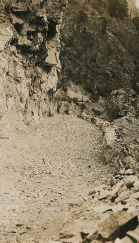
Rock cut round the first tunnel
https://search.heritageburnaby.ca/link/archivedescription34405
- Repository
- City of Burnaby Archives
- Date
- 1925
- Collection/Fonds
- Burnaby Historical Society fonds
- Description Level
- Item
- Physical Description
- 1 photograph : b&w ; 7 x 12 cm on page 17.5 x 26.5 cm
- Scope and Content
- Photograph of a road bed being cut along a rock face. A caption written under the photograph reads "rock cut round the first tunnel - the far side." The picture was taken near Yale, BC. This photograph appears to have been taken by Arthur Peers, who travelled through the Fraser River Valley and …
- Repository
- City of Burnaby Archives
- Date
- 1925
- Collection/Fonds
- Burnaby Historical Society fonds
- Subseries
- Peers family subseries
- Physical Description
- 1 photograph : b&w ; 7 x 12 cm on page 17.5 x 26.5 cm
- Description Level
- Item
- Record No.
- 020-112
- Access Restriction
- No restrictions
- Reproduction Restriction
- No known restrictions
- Accession Number
- BHS2007-04
- Scope and Content
- Photograph of a road bed being cut along a rock face. A caption written under the photograph reads "rock cut round the first tunnel - the far side." The picture was taken near Yale, BC. This photograph appears to have been taken by Arthur Peers, who travelled through the Fraser River Valley and worked on the construction of the Trans-Provincial Highway during the later 1920s.
- Media Type
- Photograph
- Photographer
- Peers, Arthur Francis "Mike"
- Notes
- Title based on caption accompanying photograph
Images

Rock cut round the first tunnel
https://search.heritageburnaby.ca/link/archivedescription34406
- Repository
- City of Burnaby Archives
- Date
- 1925
- Collection/Fonds
- Burnaby Historical Society fonds
- Description Level
- Item
- Physical Description
- 1 photograph : b&w ; 7 x 12.2 cm on page 17.5 x 26.5 cm
- Scope and Content
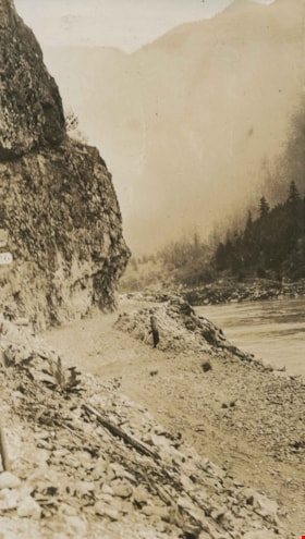
- Photograph of a road bed being cut along a rock face. A caption written under the photograph reads "rock cut round the first tunnel - the near side." The picture was taken near Yale, BC. This photograph appears to have been taken by Arthur Peers, who travelled through the Fraser River Valley and…
- Repository
- City of Burnaby Archives
- Date
- 1925
- Collection/Fonds
- Burnaby Historical Society fonds
- Subseries
- Peers family subseries
- Physical Description
- 1 photograph : b&w ; 7 x 12.2 cm on page 17.5 x 26.5 cm
- Description Level
- Item
- Record No.
- 020-113
- Access Restriction
- No restrictions
- Reproduction Restriction
- No known restrictions
- Accession Number
- BHS2007-04
- Scope and Content
- Photograph of a road bed being cut along a rock face. A caption written under the photograph reads "rock cut round the first tunnel - the near side." The picture was taken near Yale, BC. This photograph appears to have been taken by Arthur Peers, who travelled through the Fraser River Valley and worked on the construction of the Trans-Provincial Highway during the later 1920s.
- Media Type
- Photograph
- Photographer
- Peers, Arthur Francis "Mike"
- Notes
- Title based on caption accompanying photograph
Images
![Rock slide, December 10, [1926] thumbnail](/media/hpo/_Data/_Archives_Images/_Unrestricted/001/020-178.jpg?width=280)
Rock slide
https://search.heritageburnaby.ca/link/archivedescription34471
- Repository
- City of Burnaby Archives
- Date
- December 10, [1926]
- Collection/Fonds
- Burnaby Historical Society fonds
- Description Level
- Item
- Physical Description
- 1 photograph : b&w ; 7 x 11.5 cm on page 17.5 x 26.3 cm
- Scope and Content
- Photograph of three men standing on a wooden bridge next to two large boulders which have tumbled down from the rocky slope above. The caption accompanying the photograph reads: "Rock slide, Dec. 10th. Derailed Imperial Limited at 4am abd bent the overhead Bridge." This photograph appears to have…
- Repository
- City of Burnaby Archives
- Date
- December 10, [1926]
- Collection/Fonds
- Burnaby Historical Society fonds
- Subseries
- Peers family subseries
- Physical Description
- 1 photograph : b&w ; 7 x 11.5 cm on page 17.5 x 26.3 cm
- Description Level
- Item
- Record No.
- 020-178
- Access Restriction
- No restrictions
- Reproduction Restriction
- No known restrictions
- Accession Number
- BHS2007-04
- Scope and Content
- Photograph of three men standing on a wooden bridge next to two large boulders which have tumbled down from the rocky slope above. The caption accompanying the photograph reads: "Rock slide, Dec. 10th. Derailed Imperial Limited at 4am abd bent the overhead Bridge." This photograph appears to have been taken by Arthur Peers, who travelled through the Fraser River Valley and worked on the construction of the Trans-Provincial Highway during the later 1920s.
- Media Type
- Photograph
- Photographer
- Peers, Arthur Francis "Mike"
- Notes
- Title based on caption accompanying photograph
Images
![Rock slide, December 10, [1926] thumbnail](/media/hpo/_Data/_Archives_Images/_Unrestricted/001/020-178.jpg)
Rosser Avenue and William Street
https://search.heritageburnaby.ca/link/archivedescription34186
- Repository
- City of Burnaby Archives
- Date
- May 26, 1947
- Collection/Fonds
- Burnaby Historical Society fonds
- Description Level
- Item
- Physical Description
- 1 photograph : b&w negative ; 6.8 x 11.3 cm
- Scope and Content
- Photograph of Rosser Avenue and William Street with pipes being laid beside the road. Cleared land, houses and house construction are visible in the background. This is part of the Willingdon Heights subdivision site.
- Repository
- City of Burnaby Archives
- Date
- May 26, 1947
- Collection/Fonds
- Burnaby Historical Society fonds
- Subseries
- Alfred Bingham subseries
- Physical Description
- 1 photograph : b&w negative ; 6.8 x 11.3 cm
- Description Level
- Item
- Record No.
- 010-103
- Access Restriction
- No restrictions
- Reproduction Restriction
- No known restrictions
- Accession Number
- BHS2007-04
- Scope and Content
- Photograph of Rosser Avenue and William Street with pipes being laid beside the road. Cleared land, houses and house construction are visible in the background. This is part of the Willingdon Heights subdivision site.
- Media Type
- Photograph
- Photographer
- Bingham, Alfred "Alf"
- Notes
- Title based on contents of photograph
- Geographic Access
- Rosser Avenue
- William Street
Images
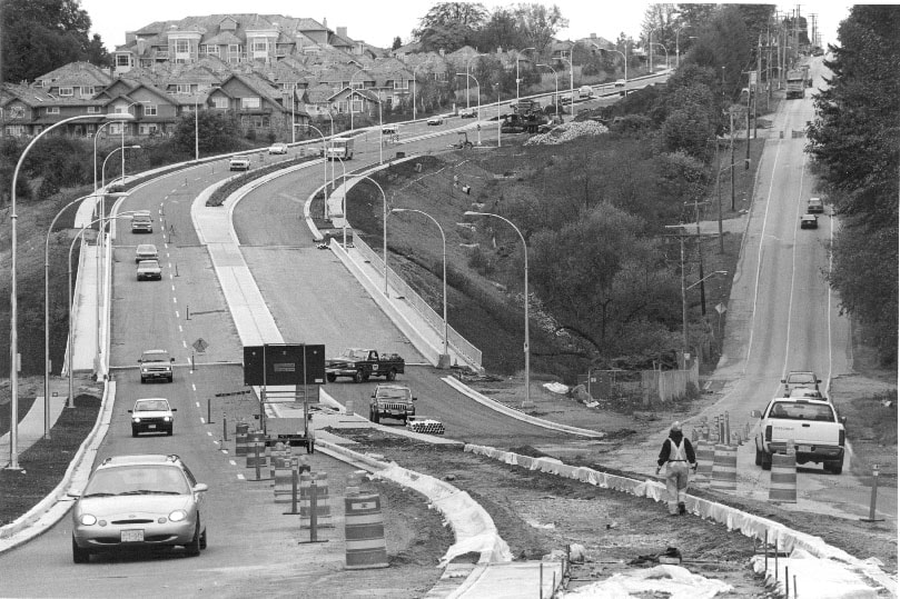
Royal Oak
https://search.heritageburnaby.ca/link/archivedescription81168
- Repository
- City of Burnaby Archives
- Date
- August 16, 1998
- Collection/Fonds
- Burnaby NewsLeader photograph collection
- Description Level
- Item
- Physical Description
- 1 photograph : b&w ; 16 x 23.5 cm
- Scope and Content
- Photograph of the nearly completed Royal Oak Avenue realignment project.
- Repository
- City of Burnaby Archives
- Date
- August 16, 1998
- Collection/Fonds
- Burnaby NewsLeader photograph collection
- Physical Description
- 1 photograph : b&w ; 16 x 23.5 cm
- Description Level
- Item
- Record No.
- 535-1314
- Access Restriction
- No restrictions
- Reproduction Restriction
- No reproduction permitted
- Accession Number
- 2012-11
- Scope and Content
- Photograph of the nearly completed Royal Oak Avenue realignment project.
- Subjects
- Construction - Road Construction
- Media Type
- Photograph
- Photographer
- Ponne, Simone
- Notes
- Title based on contents of photograph
- Note in black ink on recto of photograph reads: "1689 A Bby Simone Bby 2 46%"
- Trim marks and/or reproduction instructions on recto (scan is cropped)
Images
Royal Oak Connector
https://search.heritageburnaby.ca/link/archivedescription81228
- Repository
- City of Burnaby Archives
- Date
- October 7, 1998
- Collection/Fonds
- Burnaby NewsLeader photograph collection
- Description Level
- Item
- Physical Description
- 1 photograph : b&w ; 14 x 21 cm
- Scope and Content
- Photograph of the construction at the Royal Oak connector in Burnaby.
- Repository
- City of Burnaby Archives
- Date
- October 7, 1998
- Collection/Fonds
- Burnaby NewsLeader photograph collection
- Physical Description
- 1 photograph : b&w ; 14 x 21 cm
- Description Level
- Item
- Record No.
- 535-1372
- Access Restriction
- No restrictions
- Reproduction Restriction
- No reproduction permitted
- Accession Number
- 2012-11
- Scope and Content
- Photograph of the construction at the Royal Oak connector in Burnaby.
- Subjects
- Construction - Road Construction
- Media Type
- Photograph
- Photographer
- Bartel, Mario
- Notes
- Title based on contents of photograph
- Note in blue ink on recto of photograph reads: "Bartel Bby 1991"
- Trim marks and/or reproduction instructions on recto (scan is cropped)
- Accompanying caption reads: "Oct 7, 1998 1991: / Motorists get a taste of the new and old as construction winds down the new Royal Oak connector Monday."
Images
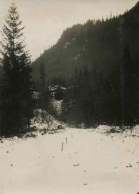
Snow covered trail
https://search.heritageburnaby.ca/link/archivedescription34467
- Repository
- City of Burnaby Archives
- Date
- 1926
- Collection/Fonds
- Burnaby Historical Society fonds
- Description Level
- Item
- Physical Description
- 1 photograph : b&w ; 7 x 9.7 cm on page 17.4 x 26.5 cm
- Scope and Content
- Photograph of a snow-covered trail that has been cleared and staked. This photograph appears to have been taken by Arthur Peers, who travelled through the Fraser River Valley and worked on the construction of the Trans-Provincial Highway during the later 1920s.
- Repository
- City of Burnaby Archives
- Date
- 1926
- Collection/Fonds
- Burnaby Historical Society fonds
- Subseries
- Peers family subseries
- Physical Description
- 1 photograph : b&w ; 7 x 9.7 cm on page 17.4 x 26.5 cm
- Description Level
- Item
- Record No.
- 020-174
- Access Restriction
- No restrictions
- Reproduction Restriction
- No known restrictions
- Accession Number
- BHS2007-04
- Scope and Content
- Photograph of a snow-covered trail that has been cleared and staked. This photograph appears to have been taken by Arthur Peers, who travelled through the Fraser River Valley and worked on the construction of the Trans-Provincial Highway during the later 1920s.
- Media Type
- Photograph
- Photographer
- Peers, Arthur Francis "Mike"
- Notes
- Title based on caption accompanying photograph
Images

![Steam shovel, [1929] (date of original), copied 1986 thumbnail](/media/hpo/_Data/_Archives_Images/_Unrestricted/204/204-174.jpg?width=280)
Steam shovel
https://search.heritageburnaby.ca/link/archivedescription35317
- Repository
- City of Burnaby Archives
- Date
- [1929] (date of original), copied 1986
- Collection/Fonds
- Burnaby Historical Society fonds
- Description Level
- Item
- Physical Description
- 1 photograph : b&w ; 12.7 x 17.8 cm print
- Scope and Content
- Photograph of a steam shovel possibly operated by Bill Speirs for the municipality of Burnaby during road construction.
- Repository
- City of Burnaby Archives
- Date
- [1929] (date of original), copied 1986
- Collection/Fonds
- Burnaby Historical Society fonds
- Subseries
- Pioneer Tales subseries
- Physical Description
- 1 photograph : b&w ; 12.7 x 17.8 cm print
- Description Level
- Item
- Record No.
- 204-174
- Access Restriction
- No restrictions
- Reproduction Restriction
- No known restrictions
- Accession Number
- BHS1988-03
- Scope and Content
- Photograph of a steam shovel possibly operated by Bill Speirs for the municipality of Burnaby during road construction.
- Media Type
- Photograph
- Notes
- Title based on contents of photograph
Images
![Steam shovel, [1929] (date of original), copied 1986 thumbnail](/media/hpo/_Data/_Archives_Images/_Unrestricted/204/204-174.jpg)

Stormont Overpass
https://search.heritageburnaby.ca/link/archivedescription45376
- Repository
- City of Burnaby Archives
- Date
- August 1978
- Collection/Fonds
- Columbian Newspaper collection
- Description Level
- Item
- Physical Description
- 1 photograph : b&w ; 12.5 x 24 cm
- Scope and Content
- Aerial photograph of Stormont Overpass which would provide a direct link from the Trans Canada Highway (previously named the 401 Freeway) to the Lougheed Highway and Simon Fraser University. This was taken when the excavation work was completed, and grading and paving still need to be done.
- Repository
- City of Burnaby Archives
- Date
- August 1978
- Collection/Fonds
- Columbian Newspaper collection
- Physical Description
- 1 photograph : b&w ; 12.5 x 24 cm
- Description Level
- Item
- Record No.
- 480-271
- Access Restriction
- No restrictions
- Reproduction Restriction
- No restrictions
- Accession Number
- 2003-02
- Scope and Content
- Aerial photograph of Stormont Overpass which would provide a direct link from the Trans Canada Highway (previously named the 401 Freeway) to the Lougheed Highway and Simon Fraser University. This was taken when the excavation work was completed, and grading and paving still need to be done.
- Media Type
- Photograph
- Photographer
- Hodge, Craig
- Notes
- Title based on contents of photograph
- Note in pencil on verso of photograph reads: "Altair Aviation / photo by / Craig Hodge"
- Geographic Access
- Cariboo Road
- Gaglardi Way
- Trans Canada Highway
- Historic Neighbourhood
- Burquitlam (Historic Neighbourhood)
- Planning Study Area
- Burnaby Lake Area
- Cameron Area
Images


Stormont Overpass
https://search.heritageburnaby.ca/link/archivedescription45377
- Repository
- City of Burnaby Archives
- Date
- August 1978
- Collection/Fonds
- Columbian Newspaper collection
- Description Level
- Item
- Physical Description
- 1 photograph : b&w ; 16.5 x 24 cm
- Scope and Content
- Aerial photograph of Stormont Overpass which would provide a direct link from the 401 Freeway to the Lougheed Highway and Simon Fraser University. This was taken when the excavation work was completed, and grading and paving still need to be done.
- Repository
- City of Burnaby Archives
- Date
- August 1978
- Collection/Fonds
- Columbian Newspaper collection
- Physical Description
- 1 photograph : b&w ; 16.5 x 24 cm
- Description Level
- Item
- Record No.
- 480-272
- Access Restriction
- No restrictions
- Reproduction Restriction
- No restrictions
- Accession Number
- 2003-02
- Scope and Content
- Aerial photograph of Stormont Overpass which would provide a direct link from the 401 Freeway to the Lougheed Highway and Simon Fraser University. This was taken when the excavation work was completed, and grading and paving still need to be done.
- Media Type
- Photograph
- Photographer
- Hodge, Craig
- Notes
- Title based on contents of photograph
- Newspaper clipping attached to verso of photograph reads: "After six years, work on the Stormont interchange in Burnaby is only a few weeks from completion. The huge clover-leaf junction of Gaglardi Way and the Freeway is on the top left-hand corner, with Gaglardi Way approaching from the bottom right where a bridge has been completed over the Burlington Northern tracks. An embankment linking that bridge with one over the Brunette River awaits only a layer of tarmac, and a path has been cleared through the woods to link up with the clover-leaf. The present access to the Freeway is along the road running from the left to right across the middle of the picture. The interchange will open next month."
- Note in pencil on verso of photograph reads: "Altair Aviation / photo by / Craig Hodge"
- Geographic Access
- Cariboo Road
- Gaglardi Way
- Trans Canada Highway
- Historic Neighbourhood
- Burquitlam (Historic Neighbourhood)
- Planning Study Area
- Burnaby Lake Area
- Cameron Area
Images

![Stormont Overpass, [1978] thumbnail](/media/hpo/_Data/_Archives_Images/_Unrestricted/480/480-275.jpg?width=280)
Stormont Overpass
https://search.heritageburnaby.ca/link/archivedescription45380
- Repository
- City of Burnaby Archives
- Date
- [1978]
- Collection/Fonds
- Columbian Newspaper collection
- Description Level
- Item
- Physical Description
- 1 photograph : b&w ; 16 x 24 cm
- Scope and Content
- Aerial photograph of Stormont Overpass which would provide a direct link from the Trans Canada Highway (previously named the 401 Freeway) to the Lougheed Highway and Simon Fraser University. This was taken when the excavation work was completed, and paving still need to be done.
- Repository
- City of Burnaby Archives
- Date
- [1978]
- Collection/Fonds
- Columbian Newspaper collection
- Physical Description
- 1 photograph : b&w ; 16 x 24 cm
- Description Level
- Item
- Record No.
- 480-275
- Access Restriction
- No restrictions
- Reproduction Restriction
- No restrictions
- Accession Number
- 2003-02
- Scope and Content
- Aerial photograph of Stormont Overpass which would provide a direct link from the Trans Canada Highway (previously named the 401 Freeway) to the Lougheed Highway and Simon Fraser University. This was taken when the excavation work was completed, and paving still need to be done.
- Media Type
- Photograph
- Photographer
- King, Basil
- Notes
- Title based on contents of photograph
- Note on verso of photograph reads: "One of the biggest Highways"
- Geographic Access
- Cariboo Road
- Gaglardi Way
- Trans Canada Highway
- Historic Neighbourhood
- Burquitlam (Historic Neighbourhood)
- Planning Study Area
- Burnaby Lake Area
- Cameron Area
Images
![Stormont Overpass, [1978] thumbnail](/media/hpo/_Data/_Archives_Images/_Unrestricted/480/480-275.jpg)
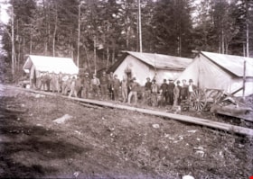
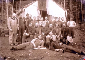
Streetcar work camp
https://search.heritageburnaby.ca/link/archivedescription57706
- Repository
- City of Burnaby Archives
- Date
- 1913
- Collection/Fonds
- J.W. Phillips fonds
- Description Level
- Item
- Physical Description
- 1 photograph : b&w glass negative ; 11 x 15.5 cm
- Scope and Content
- Photograph of labourers at a British Columbia Electric Railway Company streetcar work camp standing in a long single file row in front of three large tents at Hastings Street. This photograph was taken during construction of the Hastings Streetcar line extension.
- Repository
- City of Burnaby Archives
- Date
- 1913
- Collection/Fonds
- J.W. Phillips fonds
- Physical Description
- 1 photograph : b&w glass negative ; 11 x 15.5 cm
- Material Details
- Emulsion measures 11 x 15.5 cm on the glass; entire glass plate measures 12 x 16 cm
- Description Level
- Item
- Record No.
- 487-010
- Access Restriction
- No restrictions
- Reproduction Restriction
- No known restrictions
- Accession Number
- 2008-18
- Scope and Content
- Photograph of labourers at a British Columbia Electric Railway Company streetcar work camp standing in a long single file row in front of three large tents at Hastings Street. This photograph was taken during construction of the Hastings Streetcar line extension.
- Subjects
- Transportation - Electric Railroads
- Construction - Railroad Construction
- Occupations - Railroad Labourers
- Structures - Tents
- Media Type
- Photograph
- Photographer
- Phillips, James William "Jim"
- Notes
- Title based on contents of photograph
- Geographic Access
- Hastings Street
Images
Streetcar work camp
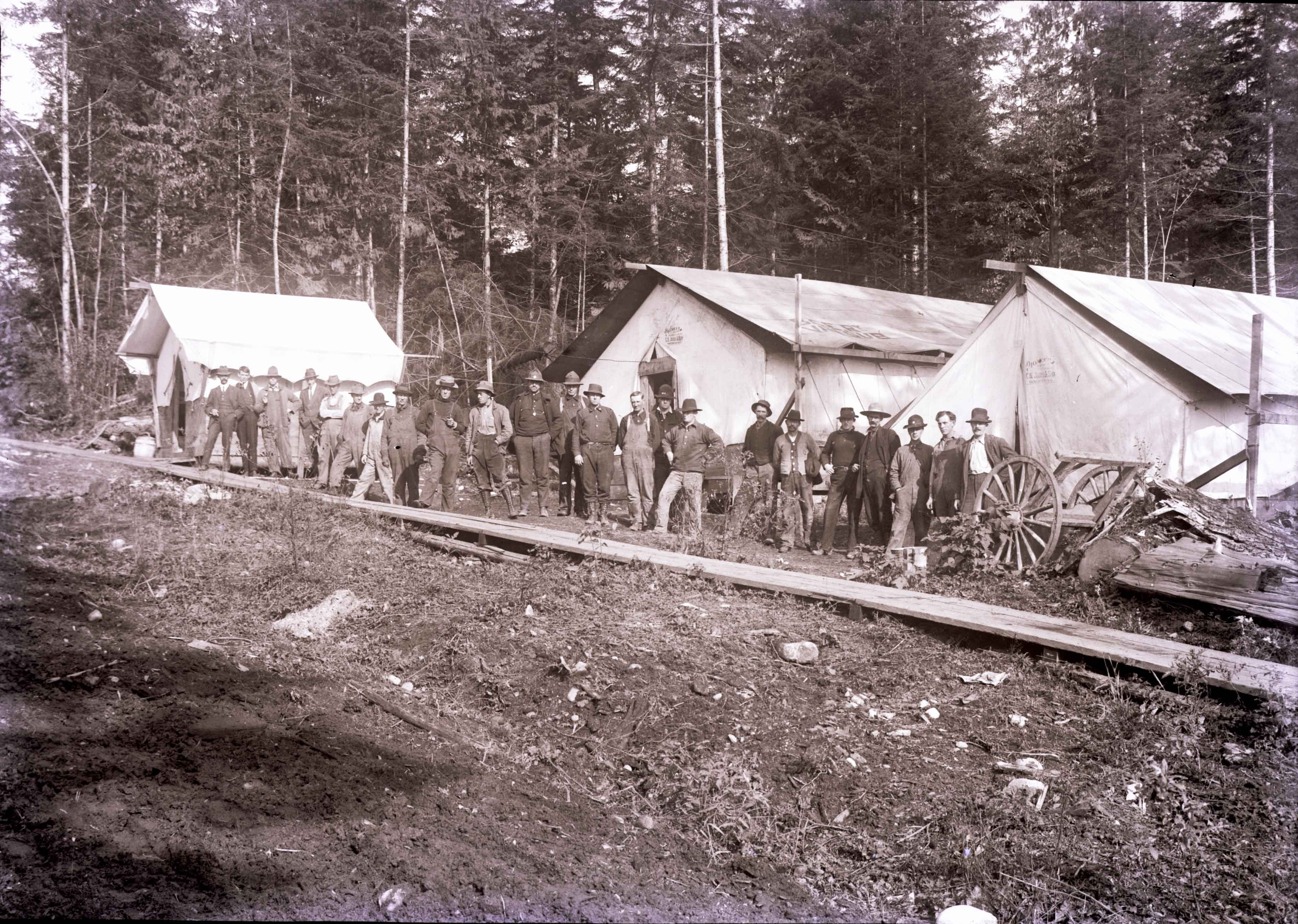
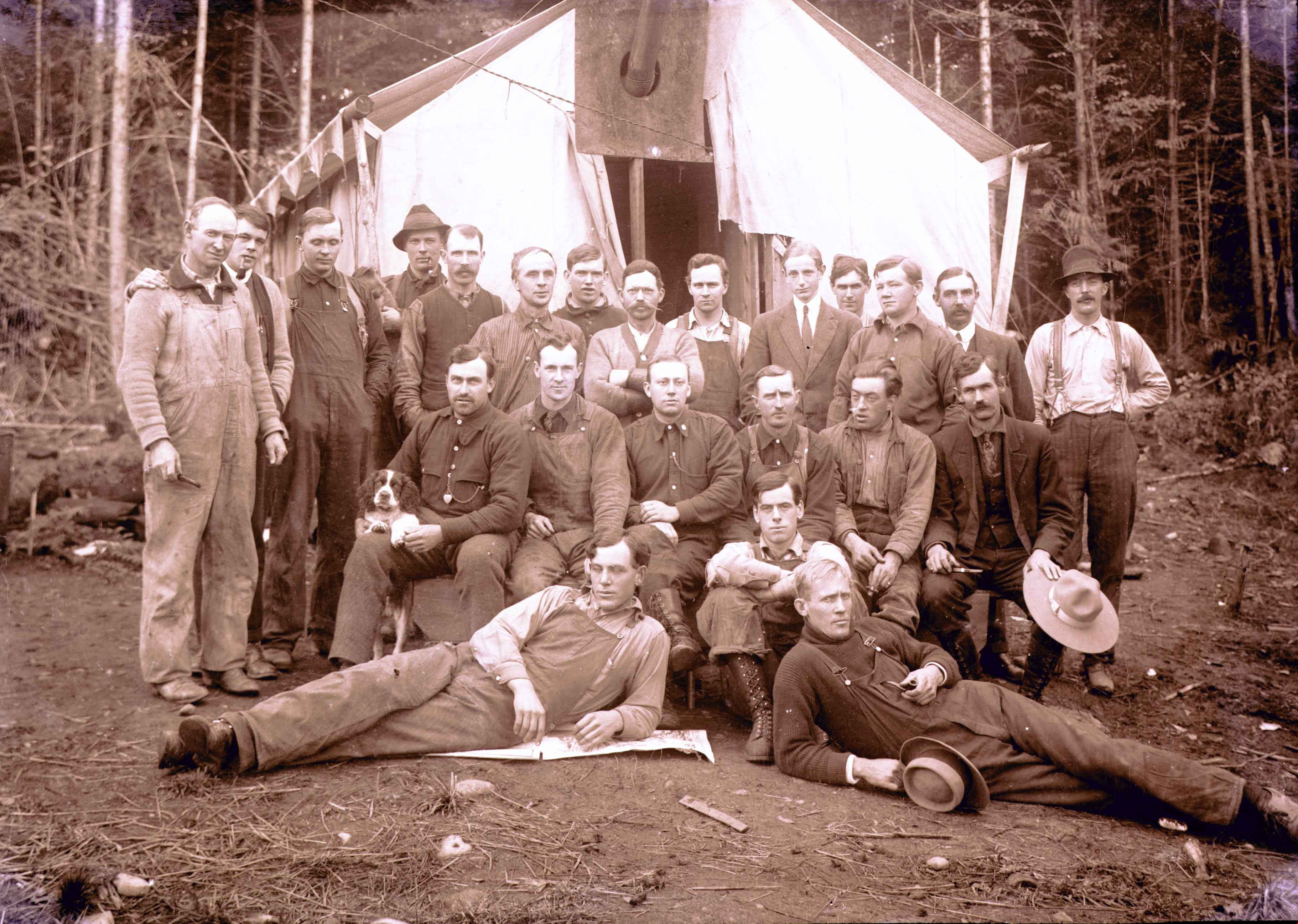
https://search.heritageburnaby.ca/link/archivedescription57707
- Repository
- City of Burnaby Archives
- Date
- 1913
- Collection/Fonds
- J.W. Phillips fonds
- Description Level
- Item
- Physical Description
- 1 photograph : b&w glass negative ; 11 x 15.5 cm
- Scope and Content
- Photograph of labourers at the British Columbia Electric Railway Company streetcar work camp standing and sitting in three rows in front of a large tent at Hastings Street. The man on the far right, sitting upright, is holding a cocker spaniel at his knee. This photograph was taken during construct…
- Repository
- City of Burnaby Archives
- Date
- 1913
- Collection/Fonds
- J.W. Phillips fonds
- Physical Description
- 1 photograph : b&w glass negative ; 11 x 15.5 cm
- Material Details
- Emulsion measures 11 x 15.5 cm on the glass; entire glass plate measures 12 x 16 cm
- Description Level
- Item
- Record No.
- 487-011
- Access Restriction
- No restrictions
- Reproduction Restriction
- No known restrictions
- Accession Number
- 2008-18
- Scope and Content
- Photograph of labourers at the British Columbia Electric Railway Company streetcar work camp standing and sitting in three rows in front of a large tent at Hastings Street. The man on the far right, sitting upright, is holding a cocker spaniel at his knee. This photograph was taken during construction of the Hastings Streetcar line extension.
- Subjects
- Transportation - Electric Railroads
- Construction - Railroad Construction
- Occupations - Railroad Labourers
- Structures - Tents
- Animals - Dogs
- Media Type
- Photograph
- Photographer
- Phillips, James William "Jim"
- Notes
- Title based on contents of photograph
- Geographic Access
- Hastings Street
Images

Streetcar work camp
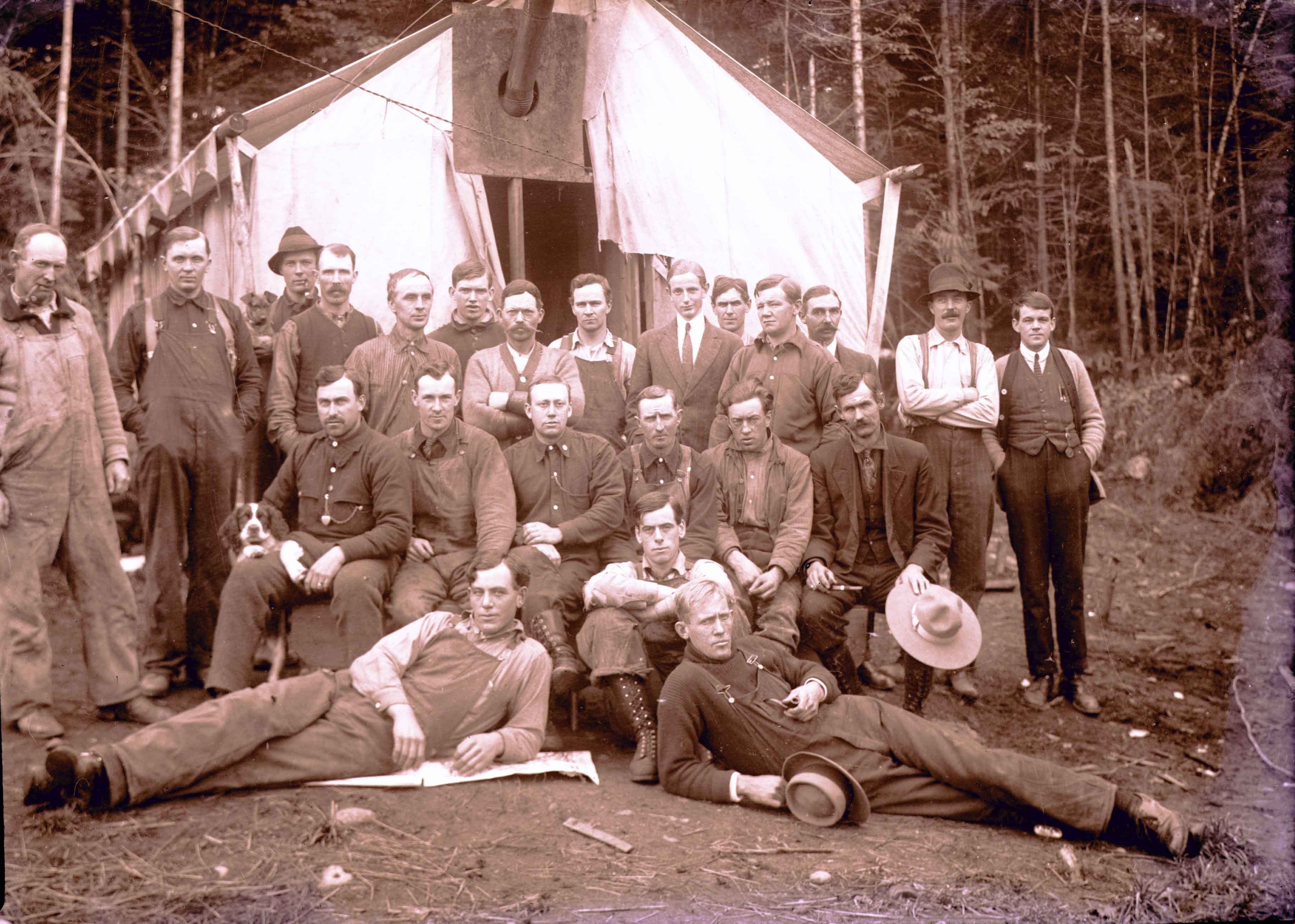
https://search.heritageburnaby.ca/link/archivedescription57708
- Repository
- City of Burnaby Archives
- Date
- 1913
- Collection/Fonds
- J.W. Phillips fonds
- Description Level
- Item
- Physical Description
- 1 photograph : b&w glass negative ; 11 x 15.5 cm
- Scope and Content
- Photograph of labourers at the British Columbia Electric Railway Company streetcar work camp standing and sitting in three rows in front of a large tent at Hastings Street. The man on the far right, sitting upright, is holding a cocker spaniel at his knee. This photograph was taken during construc…
- Repository
- City of Burnaby Archives
- Date
- 1913
- Collection/Fonds
- J.W. Phillips fonds
- Physical Description
- 1 photograph : b&w glass negative ; 11 x 15.5 cm
- Material Details
- Emulsion measures 11 x 15.5 cm on the glass; entire glass plate measures 12 x 16 cm
- Description Level
- Item
- Record No.
- 487-012
- Access Restriction
- No restrictions
- Reproduction Restriction
- No known restrictions
- Accession Number
- 2008-18
- Scope and Content
- Photograph of labourers at the British Columbia Electric Railway Company streetcar work camp standing and sitting in three rows in front of a large tent at Hastings Street. The man on the far right, sitting upright, is holding a cocker spaniel at his knee. This photograph was taken during construction of the Hastings Streetcar line extension.
- Subjects
- Transportation - Electric Railroads
- Construction - Railroad Construction
- Occupations - Railroad Labourers
- Structures - Tents
- Animals - Dogs
- Media Type
- Photograph
- Photographer
- Phillips, James William "Jim"
- Notes
- Title based on contents of photograph
- Geographic Access
- Hastings Street
Images
![Street clearing, [195-] (date of original), copied 1976 thumbnail](/media/hpo/_Data/_BVM_Images/1974/197602510027.jpg?width=280)
Street clearing
https://search.heritageburnaby.ca/link/museumdescription1622
- Repository
- Burnaby Village Museum
- Date
- [195-] (date of original), copied 1976
- Collection/Fonds
- Burnaby Village Museum Photograph collection
- Description Level
- Item
- Physical Description
- 1 photograph : col. negative ; 4.5 x 6.5 cm
- Scope and Content
- Photograph of the Grandview ramp off of the Trans Canada Highway in Burnaby that is cleared, possibly in preparation for the highway. The clearing for the street is several lanes wide, and in the distance, an overpass bridge can be seen. There are houses and along both sides of the cleared street.
- Repository
- Burnaby Village Museum
- Collection/Fonds
- Burnaby Village Museum Photograph collection
- Description Level
- Item
- Physical Description
- 1 photograph : col. negative ; 4.5 x 6.5 cm
- Scope and Content
- Photograph of the Grandview ramp off of the Trans Canada Highway in Burnaby that is cleared, possibly in preparation for the highway. The clearing for the street is several lanes wide, and in the distance, an overpass bridge can be seen. There are houses and along both sides of the cleared street.
- Accession Code
- HV976.251.27
- Access Restriction
- No restrictions
- Reproduction Restriction
- May be restricted by third party rights
- Date
- [195-] (date of original), copied 1976
- Media Type
- Photograph
- Scan Resolution
- 300
- Scan Date
- 22/8/2006
- Scale
- 100
- Notes
- Title based on contents of photograph
- The print is made as a black and white print from a colour negative film
Images
![Street clearing, [195-] (date of original), copied 1976 thumbnail](/media/hpo/_Data/_BVM_Images/1974/197602510027.jpg)
![The Three Ways Through the Canyon, [1925] thumbnail](/media/hpo/_Data/_Archives_Images/_Unrestricted/001/020-122.jpg?width=280)
The Three Ways Through the Canyon
https://search.heritageburnaby.ca/link/archivedescription34415
- Repository
- City of Burnaby Archives
- Date
- [1925]
- Collection/Fonds
- Burnaby Historical Society fonds
- Description Level
- Item
- Physical Description
- 1 photograph : b&w ; 6.7 x 12 cm on page 17.5 x 26.1 cm
- Scope and Content
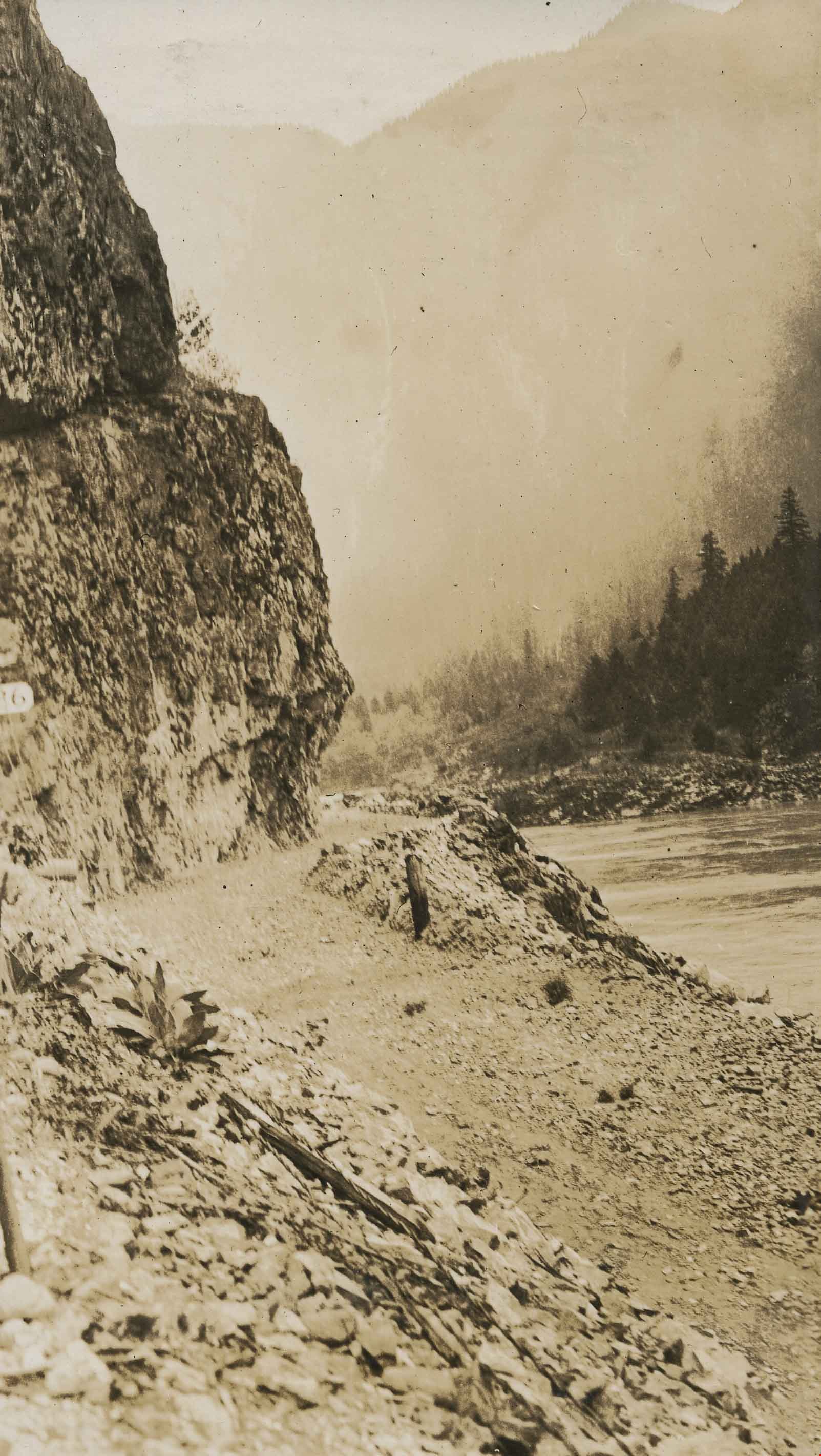
- Photograph of the view looking down the Fraser River. On the right, in the background, the CNR line is visible, while on the left can be seen the CPR line (closer to the river) and the Trans-Provincial Highway above that. These three routes are what is being referred to in the caption that accomp…
- Repository
- City of Burnaby Archives
- Date
- [1925]
- Collection/Fonds
- Burnaby Historical Society fonds
- Subseries
- Peers family subseries
- Physical Description
- 1 photograph : b&w ; 6.7 x 12 cm on page 17.5 x 26.1 cm
- Description Level
- Item
- Record No.
- 020-122
- Access Restriction
- No restrictions
- Reproduction Restriction
- No known restrictions
- Accession Number
- BHS2007-04
- Scope and Content
- Photograph of the view looking down the Fraser River. On the right, in the background, the CNR line is visible, while on the left can be seen the CPR line (closer to the river) and the Trans-Provincial Highway above that. These three routes are what is being referred to in the caption that accompanies the picture, and which reads: "The Three Ways Through the Canyon." This photograph appears to have been taken by Arthur Peers, who travelled through the Fraser River Valley and worked on the construction of the Trans-Provincial Highway during the later 1920s.
- Media Type
- Photograph
- Photographer
- Peers, Arthur Francis "Mike"
- Notes
- Title based on caption accompanying photograph
Images
![The Three Ways Through the Canyon, [1925] thumbnail](/media/hpo/_Data/_Archives_Images/_Unrestricted/001/020-122.jpg)
![The Trans-Provincial Highway, Italian's section, [1926] thumbnail](/media/hpo/_Data/_Archives_Images/_Unrestricted/001/020-201.jpg?width=280)
The Trans-Provincial Highway, Italian's section
https://search.heritageburnaby.ca/link/archivedescription34494
- Repository
- City of Burnaby Archives
- Date
- [1926]
- Collection/Fonds
- Burnaby Historical Society fonds
- Description Level
- Item
- Physical Description
- 1 photograph : b&w ; 7 x 11.9 cm on page 17.5 x 26.3 cm
- Scope and Content
- Photograph of a section of the Trans-Provincial Highway winding alongside the foot of a mountain. The location is identified only as around mile 24 of the Canadian Pacific Railway (C.P.R.). This photograph appears to have been taken by Arthur Peers, who travelled through the Fraser River Valley a…
- Repository
- City of Burnaby Archives
- Date
- [1926]
- Collection/Fonds
- Burnaby Historical Society fonds
- Subseries
- Peers family subseries
- Physical Description
- 1 photograph : b&w ; 7 x 11.9 cm on page 17.5 x 26.3 cm
- Description Level
- Item
- Record No.
- 020-201
- Access Restriction
- No restrictions
- Reproduction Restriction
- No known restrictions
- Accession Number
- BHS2007-04
- Scope and Content
- Photograph of a section of the Trans-Provincial Highway winding alongside the foot of a mountain. The location is identified only as around mile 24 of the Canadian Pacific Railway (C.P.R.). This photograph appears to have been taken by Arthur Peers, who travelled through the Fraser River Valley and worked on the construction of the Trans-Provincial Highway during the later 1920s.
- Subjects
- Construction - Road Construction
- Media Type
- Photograph
- Photographer
- Peers, Arthur Francis "Mike"
- Notes
- Title based on caption accompanying photograph
Images
![The Trans-Provincial Highway, Italian's section, [1926] thumbnail](/media/hpo/_Data/_Archives_Images/_Unrestricted/001/020-201.jpg)
![Trusses, [1919] thumbnail](/media/hpo/_Data/_BVM_Images/1974/197500330003n.jpg?width=280)
Trusses
https://search.heritageburnaby.ca/link/museumdescription3498
- Repository
- Burnaby Village Museum
- Date
- [1919]
- Collection/Fonds
- Burnaby Village Museum Photograph collection
- Description Level
- Item
- Physical Description
- 1 photograph : sepia ; 13.5 x 8 cm
- Scope and Content
- Photograph of the trusses of a bridge being built over the Campbell River. It shows the trestle before the centre span has been placed. The photographer is close to the west side (up river side) of the bridge looking north. There is a pile driving construction frame poised at the north end of the s…
- Repository
- Burnaby Village Museum
- Collection/Fonds
- Burnaby Village Museum Photograph collection
- Description Level
- Item
- Physical Description
- 1 photograph : sepia ; 13.5 x 8 cm
- Scope and Content
- Photograph of the trusses of a bridge being built over the Campbell River. It shows the trestle before the centre span has been placed. The photographer is close to the west side (up river side) of the bridge looking north. There is a pile driving construction frame poised at the north end of the span.
- History
- Bloedel Stewart and Welch built a trestle over the Campbell River in Spring 1925. BS&W acquired a timber lease on the south side of the Campbell River in order to access operations at Sayward. This is now the site of the John Hart Hydro Dam.
- Subjects
- Construction - Bridge Construction
- Accession Code
- HV975.33.3n
- Access Restriction
- No restrictions
- Date
- [1919]
- Media Type
- Photograph
- Scan Resolution
- 600
- Scan Date
- 2/2/2010
- Scale
- 100
- Notes
- Title based on contents of photograph
- Image from personal photograph album of Tom "Tommy" Irvine (HV975.33.3)
Images
![Trusses, [1919] thumbnail](/media/hpo/_Data/_BVM_Images/1974/197500330003n.jpg)
![Trusses, [1919] thumbnail](/media/hpo/_Data/_BVM_Images/1974/197500330003ac.jpg?width=280)
Trusses
https://search.heritageburnaby.ca/link/museumdescription3517
- Repository
- Burnaby Village Museum
- Date
- [1919]
- Collection/Fonds
- Burnaby Village Museum Photograph collection
- Description Level
- Item
- Physical Description
- 1 photograph : sepia ; 13.5 x 8 cm
- Scope and Content
- Photograph of the Bloedel Stewart and Welch, Campbell River trestle from the west, up river side, looking north.
- Repository
- Burnaby Village Museum
- Collection/Fonds
- Burnaby Village Museum Photograph collection
- Description Level
- Item
- Physical Description
- 1 photograph : sepia ; 13.5 x 8 cm
- Scope and Content
- Photograph of the Bloedel Stewart and Welch, Campbell River trestle from the west, up river side, looking north.
- History
- Bloedel Stewart and Welch built a trestle over the Campbell River in Spring 1925. BS&W acquired a timber lease on the south side of the Campbell River in order to access operations at Sayward. This is now the site of the John Hart Hydro Dam.
- Subjects
- Construction - Bridge Construction
- Accession Code
- HV975.33.3ac
- Access Restriction
- No restrictions
- Date
- [1919]
- Media Type
- Photograph
- Scan Resolution
- 600
- Scan Date
- 2/2/2010
- Scale
- 100
- Notes
- Title based on contents of photograph
- Image from personal photograph album of Tom "Tommy" Irvine (HV975.33.3)
Images
![Trusses, [1919] thumbnail](/media/hpo/_Data/_BVM_Images/1974/197500330003ac.jpg)
![Two bulldozers, [194-] thumbnail](/media/hpo/_Data/_BVM_Images/1971/197100120076.jpg?width=280)
Two bulldozers
https://search.heritageburnaby.ca/link/museumdescription8
- Repository
- Burnaby Village Museum
- Date
- [194-]
- Collection/Fonds
- Burnaby Village Museum Photograph collection
- Description Level
- Item
- Physical Description
- 1 photograph : b&w ; 6.8 x 11.4 cm
- Scope and Content
- Photograph of two bulldozers, belonging to "Holmes & Wilson Trucking", clearing a lot beside a row of houses. Building materials (bricks and lumber) are piled nearby. This may be related to the construction of the Willingdon Heights subdivision. Stamp on back of photograph reads: "342x."
- Repository
- Burnaby Village Museum
- Collection/Fonds
- Burnaby Village Museum Photograph collection
- Description Level
- Item
- Physical Description
- 1 photograph : b&w ; 6.8 x 11.4 cm
- Scope and Content
- Photograph of two bulldozers, belonging to "Holmes & Wilson Trucking", clearing a lot beside a row of houses. Building materials (bricks and lumber) are piled nearby. This may be related to the construction of the Willingdon Heights subdivision. Stamp on back of photograph reads: "342x."
- Subjects
- Industries - Construction
- Buildings - Residential - Houses
- Construction Tools and Equipment
- Names
- Bingham, Alfred "Alf"
- Accession Code
- HV971.12.76
- Access Restriction
- No restrictions
- Reproduction Restriction
- No known restrictions
- Date
- [194-]
- Media Type
- Photograph
- Historic Neighbourhood
- Vancouver Heights (Historic Neighbourhood)
- Planning Study Area
- Willingdon Heights Area
- Scan Resolution
- 600
- Scan Date
- 2023-03-21
- Notes
- Title based on contents of photograph
Images
![Two bulldozers, [194-] thumbnail](/media/hpo/_Data/_BVM_Images/1971/197100120076.jpg)