More like 'Boy playing in leaves at the park'
Narrow Results By
Decade
- 2020s 110
- 2010s 136
- 2000s 917
- 1990s 809
- 1980s 401
- 1970s 717
- 1960s 309
- 1950s 305
- 1940s 403
- 1930s 476
- 1920s 518
- 1910s 295
- 1900s 166
- 1890s 30
- 1880s 33
- 1870s 6
- 1860s 5
- 1850s 1
- 1840s 1
- 1830s 2
- 1820s 1
- 1810s 1
- 1800s 1
- 1790s 1
- 1780s 1
- 1770s 1
- 1760s 1
- 1750s 1
- 1740s 1
- 1730s 1
- 1720s 1
- 1710s 1
- 1700s 1
- 1690s 1
- 1680s 1
- 1670s 1
- 1660s 1
- 1650s 1
- 1640s 1
- 1630s 1
- 1620s 1
- 1610s 1
- 1600s 1
Subject
- Accidents 1
- Accidents - Automobile Accidents 1
- Adornment 4
- Adornment - Jewelry 1
- Adornment - Lapel Pins 3
- Advertising Medium 13
- Advertising Medium - Flyer 6
- Advertising Medium - Poster 1
- Advertising Medium - Signs and Signboards 55
- Aerial Photographs 37
- Agricultural Tools and Equipment 5
- Agricultural Tools and Equipment - Gardening Equipment 5

Burnaby Mountain Parking Lot & Restaurant
https://search.heritageburnaby.ca/link/archivedescription93706
- Repository
- City of Burnaby Archives
- Date
- February 15, 1978
- Collection/Fonds
- Burnaby Public Library Contemporary Visual Archive Project
- Description Level
- Item
- Physical Description
- 1 photograph : b&w ; 12.5 x 17.5 cm
- Scope and Content
- Photograph of the view of the mountains and park from a hill on Burnaby Mountain Park. The photograph is taken facing north. The photograph shows the parking lot and the Burnaby Mountain Centennial Pavilion.
- Repository
- City of Burnaby Archives
- Date
- February 15, 1978
- Collection/Fonds
- Burnaby Public Library Contemporary Visual Archive Project
- Physical Description
- 1 photograph : b&w ; 12.5 x 17.5 cm
- Description Level
- Item
- Record No.
- 556-663
- Access Restriction
- No restrictions
- Reproduction Restriction
- Reproduce for fair dealing purposes only
- Accession Number
- 2017-57
- Scope and Content
- Photograph of the view of the mountains and park from a hill on Burnaby Mountain Park. The photograph is taken facing north. The photograph shows the parking lot and the Burnaby Mountain Centennial Pavilion.
- Subjects
- Buildings - Commercial - Restaurants
- Buildings - Civic
- Buildings - Recreational
- Geographic Features - Automobile Parking Lots
- Geographic Features - Parks
- Names
- Burnaby Mountain Park
- Media Type
- Photograph
- Photographer
- Surridge, Jack
- Notes
- Title taken from project information form
- Accompanied by a project information form and 1 photograph (b&w negative ; 9.5 x 12.5 cm)
- BPL no. 111
- Geographic Access
- Burnaby Lake Regional Nature Park
- Burnaby Mountain Conservation Area
- Street Address
- 100 Centennial Way
- Planning Study Area
- Burnaby Mountain Area
Images

Interview with Alekxos Sarter by Kathy Bossort October 16, 2015 - Track 2
https://search.heritageburnaby.ca/link/oralhistory578
- Repository
- City of Burnaby Archives
- Date Range
- 1958-1992
- Length
- 0:12:40
- Summary
- This portion of the interview is about Alekxos Sarter’s first years of employment with Parks, her sources of knowledge about Burnaby Mountain, and the department’s activities in Burnaby Mountain Park. She talks about the loop trail planned for Burnaby Mountain Park in 1958, the Trans Canada Trail p…
- Repository
- City of Burnaby Archives
- Summary
- This portion of the interview is about Alekxos Sarter’s first years of employment with Parks, her sources of knowledge about Burnaby Mountain, and the department’s activities in Burnaby Mountain Park. She talks about the loop trail planned for Burnaby Mountain Park in 1958, the Trans Canada Trail project, events and issues at the Pavilion, and keeping track of trails on SFU lands.
- Date Range
- 1958-1992
- Length
- 0:12:40
- Names
- Burnaby Parks, Recreation and Cultural Services Department
- Burnaby Mountain Park
- Kamui Mintara
- Trans Canada Trail
- Geographic Access
- Burnaby Mountain Conservation Area
- Interviewer
- Bossort, Kathy
- Interview Date
- October 16, 2015
- Scope and Content
- Recording is of an interview with Alekxos Sarter conducted by Kathy Bossort. Alekxos Sarter was one of 23 participants interviewed as part of the Community Heritage Commission’s Burnaby Mountain Oral History Project. The interview is mainly about the history of setting aside parkland on Burnaby Mountain from Alekxos Sarter’s perspective and experience as employee in the City of Burnaby Parks, Recreation and Cultural Services. The interview provides an excellent explanation of the history and function of kinds of park dedications used by the City of Burnaby; an overview of issues around including the Trans Mountain tank farm in the conservation area; and the background to the land use and ownership disagreement between the City of Burnaby and Simon Fraser University, its resolution, and the subsequent development of SFU’s UniverCity. Alekxos Sarter talks about Richard Bolton, Burnaby’s Acting-Commissioner who was responsible for dedicating the first park on Burnaby Mountain in 1942, and the creation of a park named after him in UniverCity.
- Biographical Notes
- Alekxos Sarter was born in Vancouver in 1961, to Daine and Kasandra Sarter. She grew up in North Vancouver and since 1994 has lived on a sailboat in False Creek. After attending UBC where she studied landscape architecture, she was hired by the City of Burnaby Parks, Recreation and Cultural Services in 1986. Working first in parks design, Alekxos quickly moved into parks planning, her preferred career. As Research Officer she covers research, planning, public consultation, parks and facility inventory, parkland acquisition, among other duties.
- Total Tracks
- 9
- Total Length
- 2:20:47
- Interviewee Name
- Sarter, Alekxos T.
- Interview Location
- City of Burnaby Parks, Recreation and Cultural Services meeting room
- Interviewer Bio
- Kathy Bossort is a retired archivist living in Ladner, BC. She worked at the Delta Museum and Archives after graduating from SLAIS (UBC) in 2001 with Masters degrees in library science and archival studies. Kathy grew up in Calgary, Alberta, and, prior to this career change, she lived in the West Kootenays, earning her living as a cook for BC tourist lodges and work camps. She continues to be interested in oral histories as a way to fill the gaps in the written record and bring richer meaning to history.
- Collection/Fonds
- Community Heritage Commission Special Projects fonds
- Media Type
- Sound Recording
Audio Tracks
Track two of interview with Alekxos Sarter
Track two of interview with Alekxos Sarter
https://search.heritageburnaby.ca/media/hpo/_Data/_Archives_Oral_Histories/_Unrestricted/MSS196-005/MSS196-005_Track_2.mp3Interview with Henry deJong by Kathy Bossort November 6, 2015 - Track 2
https://search.heritageburnaby.ca/link/oralhistory610
- Repository
- City of Burnaby Archives
- Date Range
- 1995-2015
- Length
- 0:16:30
- Summary
- This portion of the interview is about Henry deJong’s explanation of how the 1999 Burnaby Mountain Conservation Area Plan guides work priorities in the conservation area. He gives a history of trail development since 2000, and describes how new trails are developed. He talks about discovering fish …
- Repository
- City of Burnaby Archives
- Summary
- This portion of the interview is about Henry deJong’s explanation of how the 1999 Burnaby Mountain Conservation Area Plan guides work priorities in the conservation area. He gives a history of trail development since 2000, and describes how new trails are developed. He talks about discovering fish in a tributary of Stoney Creek and closing trails to protect the area.
- Date Range
- 1995-2015
- Length
- 0:16:30
- Geographic Access
- Burnaby Mountain Conservation Area
- Interviewer
- Bossort, Kathy
- Interview Date
- November 6, 2015
- Scope and Content
- Recording is of an interview with Henry deJong conducted by Kathy Bossort. Henry deJong was one of 23 participants interviewed as part of the Community Heritage Commission’s Burnaby Mountain Oral History Project. The interview is mainly about Henry deJong’s work designing, developing and maintaining trails in the Burnaby Mountain Conservation Area as Park Design Technician for the City of Burnaby’s Parks, Recreation and Cultural Services. He provides a history of trail development after the transfer of SFU land to Burnaby and the creation of the 1999 Burnaby Mountain Conservation Area Plan. He also talks about monitoring and managing the forest environment, rehabilitating damaged areas, working with park users and stakeholders, and his favourite trails.
- Biographical Notes
- Henry G. deJong was born 1954 in Newmarket, Ontario, to Harmen and Griet deJong. He came west to enjoy outdoor recreation in BC and lived in Smithers for several years before marrying and moving to the Vancouver area, where he obtained a diploma in landscape design & horticulture from BCIT. Henry began working for the City of Burnaby in the Engineering Department in 1985, moving to Parks, Recreation and Cultural Services in 1990, and currently has the position of Park Design Technician. His focus on trail design and construction on Burnaby Mountain began in 2000 after the development of the 1999 Burnaby Mountain Conservation Area Plan. Henry lived in Burnaby for about 8 years in the Capital Hill and Edmonds area between 1983 and 1995 before moving to Cloverdale in Surrey. He belongs to the BC Mountaineering Club, the Willoughby Community Church and is a Boys Club volunteer.
- Total Tracks
- 7
- Total Length
- 1:22:41
- Interviewee Name
- deJong, Henry G.
- Interview Location
- City of Burnaby Parks, Recreation and Cultural Services meeting room
- Interviewer Bio
- Kathy Bossort is a retired archivist living in Ladner, BC. She worked at the Delta Museum and Archives after graduating from SLAIS (UBC) in 2001 with Masters degrees in library science and archival studies. Kathy grew up in Calgary, Alberta, and, prior to this career change, she lived in the West Kootenays, earning her living as a cook for BC tourist lodges and work camps. She continues to be interested in oral histories as a way to fill the gaps in the written record and bring richer meaning to history.
- Collection/Fonds
- Community Heritage Commission Special Projects fonds
- Media Type
- Sound Recording
Audio Tracks
Track two of interview with Henry deJong
Track two of interview with Henry deJong
https://search.heritageburnaby.ca/media/hpo/_Data/_Archives_Oral_Histories/_Unrestricted/MSS196-009/MSS196-009_Track_2.mp3Interview with Henry deJong by Kathy Bossort November 6, 2015 - Track 4
https://search.heritageburnaby.ca/link/oralhistory612
- Repository
- City of Burnaby Archives
- Date Range
- 2000-2015
- Length
- 0:12:00
- Summary
- This portion of the interview is about Henry deJong’s description of construction of the Velodrome Trail, how trails are named, approaches to balancing user demands with what is best for park ecology, and how trail design provides recreational value and decreases visitor impact.
- Repository
- City of Burnaby Archives
- Summary
- This portion of the interview is about Henry deJong’s description of construction of the Velodrome Trail, how trails are named, approaches to balancing user demands with what is best for park ecology, and how trail design provides recreational value and decreases visitor impact.
- Date Range
- 2000-2015
- Length
- 0:12:00
- Geographic Access
- Burnaby Mountain Conservation Area
- Interviewer
- Bossort, Kathy
- Interview Date
- November 6, 2015
- Scope and Content
- Recording is of an interview with Henry deJong conducted by Kathy Bossort. Henry deJong was one of 23 participants interviewed as part of the Community Heritage Commission’s Burnaby Mountain Oral History Project. The interview is mainly about Henry deJong’s work designing, developing and maintaining trails in the Burnaby Mountain Conservation Area as Park Design Technician for the City of Burnaby’s Parks, Recreation and Cultural Services. He provides a history of trail development after the transfer of SFU land to Burnaby and the creation of the 1999 Burnaby Mountain Conservation Area Plan. He also talks about monitoring and managing the forest environment, rehabilitating damaged areas, working with park users and stakeholders, and his favourite trails.
- Biographical Notes
- Henry G. deJong was born 1954 in Newmarket, Ontario, to Harmen and Griet deJong. He came west to enjoy outdoor recreation in BC and lived in Smithers for several years before marrying and moving to the Vancouver area, where he obtained a diploma in landscape design & horticulture from BCIT. Henry began working for the City of Burnaby in the Engineering Department in 1985, moving to Parks, Recreation and Cultural Services in 1990, and currently has the position of Park Design Technician. His focus on trail design and construction on Burnaby Mountain began in 2000 after the development of the 1999 Burnaby Mountain Conservation Area Plan. Henry lived in Burnaby for about 8 years in the Capital Hill and Edmonds area between 1983 and 1995 before moving to Cloverdale in Surrey. He belongs to the BC Mountaineering Club, the Willoughby Community Church and is a Boys Club volunteer.
- Total Tracks
- 7
- Total Length
- 1:22:41
- Interviewee Name
- deJong, Henry G.
- Interview Location
- City of Burnaby Parks, Recreation and Cultural Services meeting room
- Interviewer Bio
- Kathy Bossort is a retired archivist living in Ladner, BC. She worked at the Delta Museum and Archives after graduating from SLAIS (UBC) in 2001 with Masters degrees in library science and archival studies. Kathy grew up in Calgary, Alberta, and, prior to this career change, she lived in the West Kootenays, earning her living as a cook for BC tourist lodges and work camps. She continues to be interested in oral histories as a way to fill the gaps in the written record and bring richer meaning to history.
- Collection/Fonds
- Community Heritage Commission Special Projects fonds
- Media Type
- Sound Recording
Audio Tracks
Track four of interview with Henry deJong
Track four of interview with Henry deJong
https://search.heritageburnaby.ca/media/hpo/_Data/_Archives_Oral_Histories/_Unrestricted/MSS196-009/MSS196-009_Track_4.mp3Interview with Karen Morcke and Diane Hansen by Kathy Bossort October 9, 2015 - Track 6
https://search.heritageburnaby.ca/link/oralhistory568
- Repository
- City of Burnaby Archives
- Date Range
- 1995-2015
- Length
- 0:16:07
- Summary
- This portion of the interview is about Karen Morcke and Diane Hansen describing the ways in which people benefit from the Burnaby Mountain Conservation Area. They talk about the impact mountain biking has on the environment and on other park users, and on the problem of invasive plant species.
- Repository
- City of Burnaby Archives
- Summary
- This portion of the interview is about Karen Morcke and Diane Hansen describing the ways in which people benefit from the Burnaby Mountain Conservation Area. They talk about the impact mountain biking has on the environment and on other park users, and on the problem of invasive plant species.
- Date Range
- 1995-2015
- Length
- 0:16:07
- Geographic Access
- Burnaby Mountain Conservation Area
- Interviewer
- Bossort, Kathy
- Interview Date
- October 9, 2015
- Scope and Content
- Recording is of an interview with Karen Morcke and Diane Hansen conducted by Kathy Bossort. Karen Morcke and Diane Hansen were two of 23 participants interviewed as part of the Community Heritage Commission’s Burnaby Mountain Oral History Project. The interview is mainly about the history and activities of the Burnaby Mountain Preservation Society of which Karen Morcke and Diane Hansen were founding members, and the environmental and recreational value of the Burnaby Mountain Conservation Area. Karen Morcke also talks about walking the trails on Burnaby Mountain from 1968 to present and her involvement in other environmental groups.
- Biographical Notes
- Diane Hansen was born in Winnipeg in 1941, trained as a nurse in Toronto, and moved with her husband Ingolf Hansen to the Westridge Area in Burnaby in 1971, where Diane lived until 2010. Diane has one daughter Kristin. Karen Morcke was born in Germany in 1940, immigrating to Canada in 1968 to attend SFU. After completing her Masters degree in 1970 Karen was hired by SFU as a language instructor from which she retired in 1995. She has one son Erik and has lived almost continuously in North Burnaby since 1968. Both Diane Hansen and Karen Morcke have been active volunteers in local environmental groups and were founding members of the Burnaby Mountain Preservation Society, which formed about 1989 to lobby for a conservation area that integrated SFU land below the campus ring road with City of Burnaby parkland on Burnaby Mountain. Diane has also been active in wild bird rescue groups. Karen walked the trails on Burnaby Mountain to and from work, and began lobbying for protection of green space on Burnaby Mountain in the 1970s.
- Total Tracks
- 6
- Total Length
- 1:10:35
- Interviewee Name
- Morcke, Karen
- Hansen, H. Diane
- Interview Location
- Karen Morcke's home in Burnaby
- Interviewer Bio
- Kathy Bossort is a retired archivist living in Ladner, BC. She worked at the Delta Museum and Archives after graduating from SLAIS (UBC) in 2001 with Masters degrees in library science and archival studies. Kathy grew up in Calgary, Alberta, and, prior to this career change, she lived in the West Kootenays, earning her living as a cook for BC tourist lodges and work camps. She continues to be interested in oral histories as a way to fill the gaps in the written record and bring richer meaning to history.
- Collection/Fonds
- Community Heritage Commission Special Projects fonds
- Media Type
- Sound Recording
Audio Tracks
Track six of interview with Karen Morcke and Diane Hansen
Track six of interview with Karen Morcke and Diane Hansen
https://search.heritageburnaby.ca/media/hpo/_Data/_Archives_Oral_Histories/_Unrestricted/MSS196-003/MSS196-003_Track_6.mp3Interview with Lee Rankin by Kathy Bossort December 2, 2015 - Track 8
https://search.heritageburnaby.ca/link/oralhistory649
- Repository
- City of Burnaby Archives
- Date Range
- 1995-2015
- Length
- 0:11:13
- Summary
- This portion of the interview is about what the traditional landmark character of Burnaby Mountain means to Lee Rankin. He also talks about the future of the urban forest on Burnaby Mountain, and the legacy created for future generations by protecting the land as a park.
- Repository
- City of Burnaby Archives
- Summary
- This portion of the interview is about what the traditional landmark character of Burnaby Mountain means to Lee Rankin. He also talks about the future of the urban forest on Burnaby Mountain, and the legacy created for future generations by protecting the land as a park.
- Date Range
- 1995-2015
- Length
- 0:11:13
- Geographic Access
- Burnaby Mountain Conservation Area
- Interviewer
- Bossort, Kathy
- Interview Date
- December 2, 2015
- Scope and Content
- Recording is of an interview with Lee Rankin conducted by Kathy Bossort. Lee Rankin was one of 23 participants interviewed as part of the Community Heritage Commission’s Burnaby Mountain Oral History Project. The interview is mainly about Lee Rankin’s involvement in finding a resolution to the dispute between the City of Burnaby and Simon Fraser University over land ownership and control on Burnaby Mountain. He talks about the origin of the dispute, the positions taken by the two sides, the key people who brought about a resolution, and the main features of the agreement between the City, SFU and the province of BC. He talks about how the agreement met SFU’s goals, fostered trust between the City and university, and removed uncertainty from protecting parkland on Burnaby Mountain.
- Biographical Notes
- Lee Rankin was born in 1953 in Vancouver. He attended SFU 1973-78, completing his BA degree in 1985. He earned his law degree at UBC in 1988, was called to the Bar in 1989, and practiced in immigration and refugee law. Lee has lived in Burnaby since 1976 and was a member of Burnaby Council for 22 years, from 1983-1999 and 2002-2008. His particular interests as a Councillor were in community planning, housing and environment. Among other duties and accomplishments as Councillor, Lee served as chair of the Simon Fraser Liaison Committee and was involved in the negotiations with the province and SFU that resulted in the university returning more than 800 acres of land to the City, which was dedicated as part of the Burnaby Mountain Conservation Area. He has also served on the GVRD, volunteers as a coach for team sports in Burnaby, and has served on numerous community and business associations and committees. Lee is married to Ragini Venkat Rankin and has one son Henry.
- Total Tracks
- 8
- Total Length
- 1:50:35
- Interviewee Name
- Rankin, Lee A.
- Interview Location
- Lee Rankin's home in Burnaby
- Interviewer Bio
- Kathy Bossort is a retired archivist living in Ladner, BC. She worked at the Delta Museum and Archives after graduating from SLAIS (UBC) in 2001 with Masters degrees in library science and archival studies. Kathy grew up in Calgary, Alberta, and, prior to this career change, she lived in the West Kootenays, earning her living as a cook for BC tourist lodges and work camps. She continues to be interested in oral histories as a way to fill the gaps in the written record and bring richer meaning to history.
- Collection/Fonds
- Community Heritage Commission Special Projects fonds
- Media Type
- Sound Recording
Audio Tracks
Track eight of interview with Lee Rankin
Track eight of interview with Lee Rankin
https://search.heritageburnaby.ca/media/hpo/_Data/_Archives_Oral_Histories/_Unrestricted/MSS196-014/MSS196-014_Track_8.mp3Interview with Rick Sporns by Kathy Bossort October 30, 2015 - Track 5
https://search.heritageburnaby.ca/link/oralhistory607
- Repository
- City of Burnaby Archives
- Date Range
- 1985-2015
- Length
- 0:10:19
- Summary
- This portion of the interview is about Rick Sporn’s views about public feeling for the natural areas of Burnaby, how Park’s staff responds to public concerns, and how natural areas attract people and businesses to Burnaby. He talks about how management of the conservation area on Burnaby Mountain i…
- Repository
- City of Burnaby Archives
- Summary
- This portion of the interview is about Rick Sporn’s views about public feeling for the natural areas of Burnaby, how Park’s staff responds to public concerns, and how natural areas attract people and businesses to Burnaby. He talks about how management of the conservation area on Burnaby Mountain is focused on trail management and dispersing and directing park use.
- Date Range
- 1985-2015
- Length
- 0:10:19
- Geographic Access
- Burnaby Mountain Conservation Area
- Interviewer
- Bossort, Kathy
- Interview Date
- October 30, 2015
- Scope and Content
- Recording is of an interview with Rick Sporns conducted by Kathy Bossort. Rick Sporns was one of 23 participants interviewed as part of the Community Heritage Commission’s Burnaby Mountain Oral History Project. The interview is mainly about Rick Sporn’s description of the history and design of Burnaby Mountain Centennial Rose Garden and the significance of the Centennial Pavilion area in the Burnaby Mountain Conservation Area. Rick Sporns also talks about his career with the City of Burnaby’s Parks, Recreation and Cultural Services, management of Burnaby Mountain Conservation Area, and the value of natural areas to Burnaby.
- Biographical Notes
- Richard Sporns was born in 1957 in Daly Municipality, Manitoba, to Ulrich and Charlotte Sporns. The family moved to the Burquitlam Area of Burnaby in about 1965. Rick Sporns obtained his BSc degree in biology at SFU and a degree in landscape architecture at UBC. In 1985 he began his career in the City of Burnaby’s Park, Recreation and Cultural Services department where he currently is Assistant Manager - Parks Design. Rick was responsible for designing Burnaby Mountain Centennial Rose Garden, a legacy project proposed by Mark Stockdale to commemorate Burnaby’s 1992 Centennial. The rose garden opened to the public July 18, 1992.
- Total Tracks
- 6
- Total Length
- 1:01:40
- Interviewee Name
- Sporns, Richard "Rick"
- Interview Location
- City of Burnaby Parks, Recreation and Cultural Services meeting room
- Interviewer Bio
- Kathy Bossort is a retired archivist living in Ladner, BC. She worked at the Delta Museum and Archives after graduating from SLAIS (UBC) in 2001 with Masters degrees in library science and archival studies. Kathy grew up in Calgary, Alberta, and, prior to this career change, she lived in the West Kootenays, earning her living as a cook for BC tourist lodges and work camps. She continues to be interested in oral histories as a way to fill the gaps in the written record and bring richer meaning to history.
- Collection/Fonds
- Community Heritage Commission Special Projects fonds
- Media Type
- Sound Recording
Audio Tracks
Track five of interview with Rick Sporns
Track five of interview with Rick Sporns
https://search.heritageburnaby.ca/media/hpo/_Data/_Archives_Oral_Histories/_Unrestricted/MSS196-008/MSS196-008_Track_5.mp3![Joseph Santos at Barnet Marine Park, [2001] thumbnail](/media/hpo/_Data/_Archives_Images/_Unrestricted/535/535-2587.jpg?width=280)
Joseph Santos at Barnet Marine Park
https://search.heritageburnaby.ca/link/archivedescription97059
- Repository
- City of Burnaby Archives
- Date
- [2001]
- Collection/Fonds
- Burnaby NewsLeader photograph collection
- Description Level
- Item
- Physical Description
- 1 photograph (tiff) : col.
- Scope and Content
- Photograph of Joseph Santos in a rain poncho, searching for sea worms on the shores of the Burrard Inlet at Barnet Marine Park. An unidentified person fishing off the pier is visible behind Santos.
- Repository
- City of Burnaby Archives
- Date
- [2001]
- Collection/Fonds
- Burnaby NewsLeader photograph collection
- Physical Description
- 1 photograph (tiff) : col.
- Description Level
- Item
- Record No.
- 535-2587
- Access Restriction
- No restrictions
- Reproduction Restriction
- No restrictions
- Accession Number
- 2018-12
- Scope and Content
- Photograph of Joseph Santos in a rain poncho, searching for sea worms on the shores of the Burrard Inlet at Barnet Marine Park. An unidentified person fishing off the pier is visible behind Santos.
- Media Type
- Photograph
- Photographer
- Bartel, Mario
- Notes
- Title based on caption
- Collected by editorial for use in a July 2001 issue of the Burnaby NewsLeader
- Caption from metadata: "Joseph Santos isn't deterred by the soggy weather as he searches for sea worms to be used as bait at a family fishing expedition at Barnet Marine Park."
- Geographic Access
- Barnet Marine Park
- Burrard Inlet
- Historic Neighbourhood
- Barnet (Historic Neighbourhood)
- Planning Study Area
- Burnaby Mountain Area
Images
![Joseph Santos at Barnet Marine Park, [2001] thumbnail](/media/hpo/_Data/_Archives_Images/_Unrestricted/535/535-2587.jpg)
![Kensington Pitch & Putt, [2000] thumbnail](/media/hpo/_Data/_Archives_Images/_Unrestricted/535/535-3103.jpg?width=280)
Kensington Pitch & Putt
https://search.heritageburnaby.ca/link/archivedescription97999
- Repository
- City of Burnaby Archives
- Date
- [2000]
- Collection/Fonds
- Burnaby NewsLeader photograph collection
- Description Level
- Item
- Physical Description
- 1 photograph (tiff) : col.
- Scope and Content
- Photograph of Joaquin Ortega putting on a green at the Kensington Pitch & Putt course. The snow-covered mountains are visible in the background.
- Repository
- City of Burnaby Archives
- Date
- [2000]
- Collection/Fonds
- Burnaby NewsLeader photograph collection
- Physical Description
- 1 photograph (tiff) : col.
- Description Level
- Item
- Record No.
- 535-3103
- Access Restriction
- No restrictions
- Reproduction Restriction
- No restrictions
- Accession Number
- 2018-12
- Scope and Content
- Photograph of Joaquin Ortega putting on a green at the Kensington Pitch & Putt course. The snow-covered mountains are visible in the background.
- Media Type
- Photograph
- Photographer
- Bartel, Mario
- Notes
- Title based on caption
- Collected by editorial for use in a February 2000 issue of the Burnaby NewsLeader
- Caption from metadata: "A sure sign of Spring is the official opening of the Kensington Pitch & Putt golf course. Joaquin Ortega putts out on a beautiful sunny morning."
- Geographic Access
- Curtis Street
- Street Address
- 5889 Curtis Street
- Planning Study Area
- Parkcrest-Aubrey Area
Images
![Kensington Pitch & Putt, [2000] thumbnail](/media/hpo/_Data/_Archives_Images/_Unrestricted/535/535-3103.jpg)

Chalk drawings in support of public health workers
https://search.heritageburnaby.ca/link/museumdescription14737
- Repository
- Burnaby Village Museum
- Date
- 9 Apr. 2020
- Collection/Fonds
- Burnaby Village Museum COVID-19 collection
- Description Level
- Item
- Physical Description
- 1 photograph (jpg) : col. ; 72 dpi.
- Scope and Content
- Photograph of a basketball court in Montecito Park with coloured chalk drawings with hearts and the words "Thank you!!" and "Stay Safe!". These messages were created in support of public health workers during the beginning of the COVID-19 pandemic in British Columbia. The basketball court was close…
- Repository
- Burnaby Village Museum
- Collection/Fonds
- Burnaby Village Museum COVID-19 collection
- Description Level
- Item
- Physical Description
- 1 photograph (jpg) : col. ; 72 dpi.
- Scope and Content
- Photograph of a basketball court in Montecito Park with coloured chalk drawings with hearts and the words "Thank you!!" and "Stay Safe!". These messages were created in support of public health workers during the beginning of the COVID-19 pandemic in British Columbia. The basketball court was closed down along with other parks by the City of Burnaby in the spring of 2020 due to the COVID-19 pandemic and public health orders. The shadow of the photographer is visible in the foreground.
- History
- Tristan Johnson took photos around Burnaby because as a parent of two elementary school aged children during the COVID-19 pandemic, one of the most notable things about COVID-19 during Spring 2020 was the closure of playgrounds and the playgrounds being taped up.
- Accession Code
- BV020.21.2
- Access Restriction
- No restrictions
- Reproduction Restriction
- No known restrictions
- Date
- 9 Apr. 2020
- Media Type
- Photograph
- Historic Neighbourhood
- Lochdale (Historic Neighbourhood)
- Planning Study Area
- Sperling-Broadway Area
- Photographer
- Johnson, Tristan
- Notes
- Title based on contents of photograph
Images

![Children playing on a high bar, [1929] (date of original), copied 1992 thumbnail](/media/hpo/_Data/_Archives_Images/_Unrestricted/315/315-390.jpg?width=280)
Children playing on a high bar
https://search.heritageburnaby.ca/link/archivedescription36932
- Repository
- City of Burnaby Archives
- Date
- [1929] (date of original), copied 1992
- Collection/Fonds
- Burnaby Historical Society fonds
- Description Level
- Item
- Physical Description
- 1 photograph : b&w ; 8.8 x 12.7 cm print
- Scope and Content
- Photograph of three children hanging onto a high bar. Left to right: Ralph, Murial and Edgar.
- Repository
- City of Burnaby Archives
- Date
- [1929] (date of original), copied 1992
- Collection/Fonds
- Burnaby Historical Society fonds
- Subseries
- Burnaby Centennial Anthology subseries
- Physical Description
- 1 photograph : b&w ; 8.8 x 12.7 cm print
- Description Level
- Item
- Record No.
- 315-390
- Access Restriction
- No restrictions
- Reproduction Restriction
- No known restrictions
- Accession Number
- BHS1994-04
- Scope and Content
- Photograph of three children hanging onto a high bar. Left to right: Ralph, Murial and Edgar.
- Subjects
- Recreational Devices - Playgrounds
- Media Type
- Photograph
- Notes
- Title based on contents of photograph
- Annotation at bottom of photograph lists children's names
Images
![Children playing on a high bar, [1929] (date of original), copied 1992 thumbnail](/media/hpo/_Data/_Archives_Images/_Unrestricted/315/315-390.jpg)

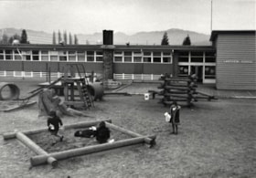
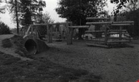
Clinton Elementary School Playground
https://search.heritageburnaby.ca/link/archivedescription79611
- Repository
- City of Burnaby Archives
- Date
- September 22, 1976
- Collection/Fonds
- Burnaby Public Library Contemporary Visual Archive Project
- Description Level
- Item
- Physical Description
- 1 photograph : b&w ; 11 x 16 cm mounted on cardboard
- Scope and Content
- Photograph shows the playground at Clinton Elementary School, 5858 Clinton Street.
- Repository
- City of Burnaby Archives
- Date
- September 22, 1976
- Collection/Fonds
- Burnaby Public Library Contemporary Visual Archive Project
- Physical Description
- 1 photograph : b&w ; 11 x 16 cm mounted on cardboard
- Description Level
- Item
- Record No.
- 556-353
- Access Restriction
- No restrictions
- Reproduction Restriction
- Reproduce for fair dealing purposes only
- Accession Number
- 2013-13
- Scope and Content
- Photograph shows the playground at Clinton Elementary School, 5858 Clinton Street.
- Media Type
- Photograph
- Photographer
- Ross, Martha
- Notes
- Scope note taken directly from BPL photograph description.
- 1 b&w copy negative : 10 x 12.5 cm accompanying
- Geographic Access
- Clinton Street
- Street Address
- 5858 Clinton Street
- Historic Neighbourhood
- Alta-Vista (Historic Neighbourhood)
- Planning Study Area
- Clinton-Glenwood Area
Images


Confederation park playground closure
https://search.heritageburnaby.ca/link/archivedescription95102
- Repository
- City of Burnaby Archives
- Date
- April 29, 2020
- Collection/Fonds
- Burnaby Photographic Society fonds
- Description Level
- Item
- Physical Description
- 1 photograph (tiff)
- Scope and Content
- Photograph of a City of Burnaby facility closure sign at Confederation Park. Sign is attached to security fencing closing off the playground equipment at the park.
- Repository
- City of Burnaby Archives
- Date
- April 29, 2020
- Collection/Fonds
- Burnaby Photographic Society fonds
- Physical Description
- 1 photograph (tiff)
- Description Level
- Item
- Record No.
- 623-020
- Access Restriction
- No restrictions
- Reproduction Restriction
- No restrictions
- Accession Number
- 2020-10
- Scope and Content
- Photograph of a City of Burnaby facility closure sign at Confederation Park. Sign is attached to security fencing closing off the playground equipment at the park.
- Media Type
- Photograph
- Photographer
- King, Gloria
- Notes
- Transcribed title
- Geographic Access
- Albert Street
- Confederation Park
- Planning Study Area
- Capitol Hill Area
Images

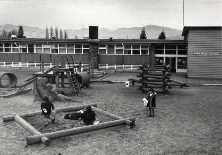
Lakeview Elementary School Playground
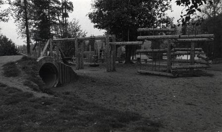
https://search.heritageburnaby.ca/link/archivedescription79612
- Repository
- City of Burnaby Archives
- Date
- February 7, 1977
- Collection/Fonds
- Burnaby Public Library Contemporary Visual Archive Project
- Description Level
- Item
- Physical Description
- 1 photograph : b&w ; 11 x 16 cm mounted on cardboard
- Scope and Content
- Photograph shows the playground at Lakeview Elementary School, 7777 Mayfield Street.
- Repository
- City of Burnaby Archives
- Date
- February 7, 1977
- Collection/Fonds
- Burnaby Public Library Contemporary Visual Archive Project
- Physical Description
- 1 photograph : b&w ; 11 x 16 cm mounted on cardboard
- Description Level
- Item
- Record No.
- 556-354
- Access Restriction
- No restrictions
- Reproduction Restriction
- Reproduce for fair dealing purposes only
- Accession Number
- 2013-13
- Scope and Content
- Photograph shows the playground at Lakeview Elementary School, 7777 Mayfield Street.
- Media Type
- Photograph
- Notes
- Scope note taken directly from BPL photograph description.
- 1 b&w copy negative : 10 x 12.5 cm accompanying
- Photographers identified by surnames only: Carr and Vardeman
- Geographic Access
- Mayfield Street
- Street Address
- 7777 Mayfield Street
- Planning Study Area
- Lakeview-Mayfield Area
Images

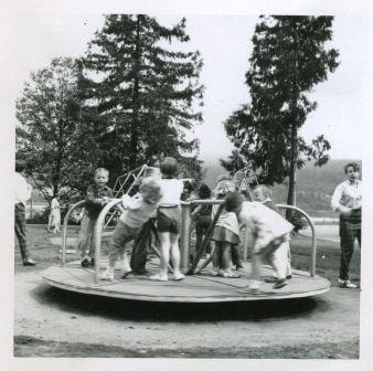
Merry - go - round
https://search.heritageburnaby.ca/link/archivedescription53038
- Repository
- City of Burnaby Archives
- Date
- June 1960
- Collection/Fonds
- Burnaby Historical Society fonds
- Description Level
- Item
- Physical Description
- 1 photograph : b&w ; 7.5 x 7.5 cm, mounted on heavy-weight paper 28.5 x 20 cm
- Scope and Content
- Photograph of the Tinkerbell Cooperative Kindergarten class having a picnic in Port Moody. The children are spining on a merry-go-round.
- Repository
- City of Burnaby Archives
- Date
- June 1960
- Collection/Fonds
- Burnaby Historical Society fonds
- Subseries
- Tinkerbell Kindergarten subseries
- Physical Description
- 1 photograph : b&w ; 7.5 x 7.5 cm, mounted on heavy-weight paper 28.5 x 20 cm
- Description Level
- Item
- Record No.
- 246-047
- Access Restriction
- No restrictions
- Reproduction Restriction
- Reproduce for fair dealing purposes only
- Accession Number
- BHS1990-12
- Scope and Content
- Photograph of the Tinkerbell Cooperative Kindergarten class having a picnic in Port Moody. The children are spining on a merry-go-round.
- Subjects
- Recreational Devices - Playgrounds
- Media Type
- Photograph
- Notes
- Title based on contents of photograph
Images

No playing here
https://search.heritageburnaby.ca/link/archivedescription95110
- Repository
- City of Burnaby Archives
- Date
- April 24, 2020
- Collection/Fonds
- Burnaby Photographic Society fonds
- Description Level
- Item
- Physical Description
- 1 photograph (tiff)
- Scope and Content
- Photograph of playground equipment taped off with caution tape at Royal Oakland Park. A red City of Burnaby facility closure sign posted to the playground is visible through the top of a slide.
- Repository
- City of Burnaby Archives
- Date
- April 24, 2020
- Collection/Fonds
- Burnaby Photographic Society fonds
- Physical Description
- 1 photograph (tiff)
- Description Level
- Item
- Record No.
- 623-028
- Access Restriction
- No restrictions
- Reproduction Restriction
- No restrictions
- Accession Number
- 2020-10
- Scope and Content
- Photograph of playground equipment taped off with caution tape at Royal Oakland Park. A red City of Burnaby facility closure sign posted to the playground is visible through the top of a slide.
- Media Type
- Photograph
- Photographer
- Snowdon, Nick
- Notes
- Transcribed title
- Photographer's caption: "Most playgrounds are taped off"
- Geographic Access
- Oakmount Crescent
- Historic Neighbourhood
- Central Park (Historic Neighbourhood)
- Planning Study Area
- Windsor Area
Images

Playground
https://search.heritageburnaby.ca/link/archivedescription79745
- Repository
- City of Burnaby Archives
- Date
- October 23, 1976
- Collection/Fonds
- Burnaby Public Library Contemporary Visual Archive Project
- Description Level
- Item
- Physical Description
- 1 photograph : b&w ; 11 x 16 cm mounted on cardboard
- Scope and Content
- Photograph shows a playground in the 9600 block of Casewell Street.
- Repository
- City of Burnaby Archives
- Date
- October 23, 1976
- Collection/Fonds
- Burnaby Public Library Contemporary Visual Archive Project
- Physical Description
- 1 photograph : b&w ; 11 x 16 cm mounted on cardboard
- Description Level
- Item
- Record No.
- 556-416
- Access Restriction
- No restrictions
- Reproduction Restriction
- Reproduce for fair dealing purposes only
- Accession Number
- 2013-13
- Scope and Content
- Photograph shows a playground in the 9600 block of Casewell Street.
- Subjects
- Recreational Devices - Playgrounds
- Media Type
- Photograph
- Photographer
- Campbell, Peg
- Notes
- Scope note taken directly from BPL photograph description.
- 1 b&w copy negative : 10 x 12.5 cm accompanying
- Geographic Access
- Casewell Street
- Historic Neighbourhood
- Burquitlam (Historic Neighbourhood)
- Planning Study Area
- Lyndhurst Area
Images

Playground at Sperling Elementary School
https://search.heritageburnaby.ca/link/museumdescription14738
- Repository
- Burnaby Village Museum
- Date
- 9 Apr. 2020
- Collection/Fonds
- Burnaby Village Museum COVID-19 collection
- Description Level
- Item
- Physical Description
- 1 photograph (jpg) : col. ; 72 dpi.
- Scope and Content
- Photograph of the playground outside of Sperling Elementary School in Burnaby. The playground equipment is surrounded by yellow caution tape to prevent anyone from using it. The playground was closed down along with other parks by the City of Burnaby in the spring of 2020 due to the COVID-19 pandem…
- Repository
- Burnaby Village Museum
- Collection/Fonds
- Burnaby Village Museum COVID-19 collection
- Description Level
- Item
- Physical Description
- 1 photograph (jpg) : col. ; 72 dpi.
- Scope and Content
- Photograph of the playground outside of Sperling Elementary School in Burnaby. The playground equipment is surrounded by yellow caution tape to prevent anyone from using it. The playground was closed down along with other parks by the City of Burnaby in the spring of 2020 due to the COVID-19 pandemic and public health orders.
- History
- Tristan Johnson took photos around Burnaby because as a parent of two elementary school aged children during the COVID-19 pandemic, one of the most notable things about COVID-19 during Spring 2020 was the closure of playgrounds and the playgrounds being taped up.
- Names
- Sperling Avenue School
- Accession Code
- BV020.21.3
- Access Restriction
- No restrictions
- Reproduction Restriction
- No known restrictions
- Date
- 9 Apr. 2020
- Media Type
- Photograph
- Historic Neighbourhood
- Lochdale (Historic Neighbourhood)
- Planning Study Area
- Sperling-Broadway Area
- Photographer
- Johnson, Tristan
- Notes
- Title based on contents of photograph
Images


Playground in Montecito Park
https://search.heritageburnaby.ca/link/museumdescription14739
- Repository
- Burnaby Village Museum
- Date
- 9 Apr. 2020
- Collection/Fonds
- Burnaby Village Museum COVID-19 collection
- Description Level
- Item
- Physical Description
- 1 photograph (jpg) : col. ; 72 dpi.
- Scope and Content
- Photograph of the playground inside of Montecito Park in Burnaby. The playground equipment is surrounded by yellow caution tape to prevent anyone from using it. The playground was closed down along with other parks by the City of Burnaby in the spring of 2020 due to the COVID-19 pandemic and public…
- Repository
- Burnaby Village Museum
- Collection/Fonds
- Burnaby Village Museum COVID-19 collection
- Description Level
- Item
- Physical Description
- 1 photograph (jpg) : col. ; 72 dpi.
- Scope and Content
- Photograph of the playground inside of Montecito Park in Burnaby. The playground equipment is surrounded by yellow caution tape to prevent anyone from using it. The playground was closed down along with other parks by the City of Burnaby in the spring of 2020 due to the COVID-19 pandemic and public health orders.
- History
- Tristan Johnson took photos around Burnaby because as a parent of two elementary school aged children during the COVID-19 pandemic, one of the most notable things about COVID-19 during Spring 2020 was the closure of playgrounds and the playgrounds being taped up.
- Names
- Sperling Avenue School
- Accession Code
- BV020.21.4
- Access Restriction
- No restrictions
- Reproduction Restriction
- No known restrictions
- Date
- 9 Apr. 2020
- Media Type
- Photograph
- Historic Neighbourhood
- Lochdale (Historic Neighbourhood)
- Planning Study Area
- Sperling-Broadway Area
- Photographer
- Johnson, Tristan
- Notes
- Title based on contents of photograph
Images

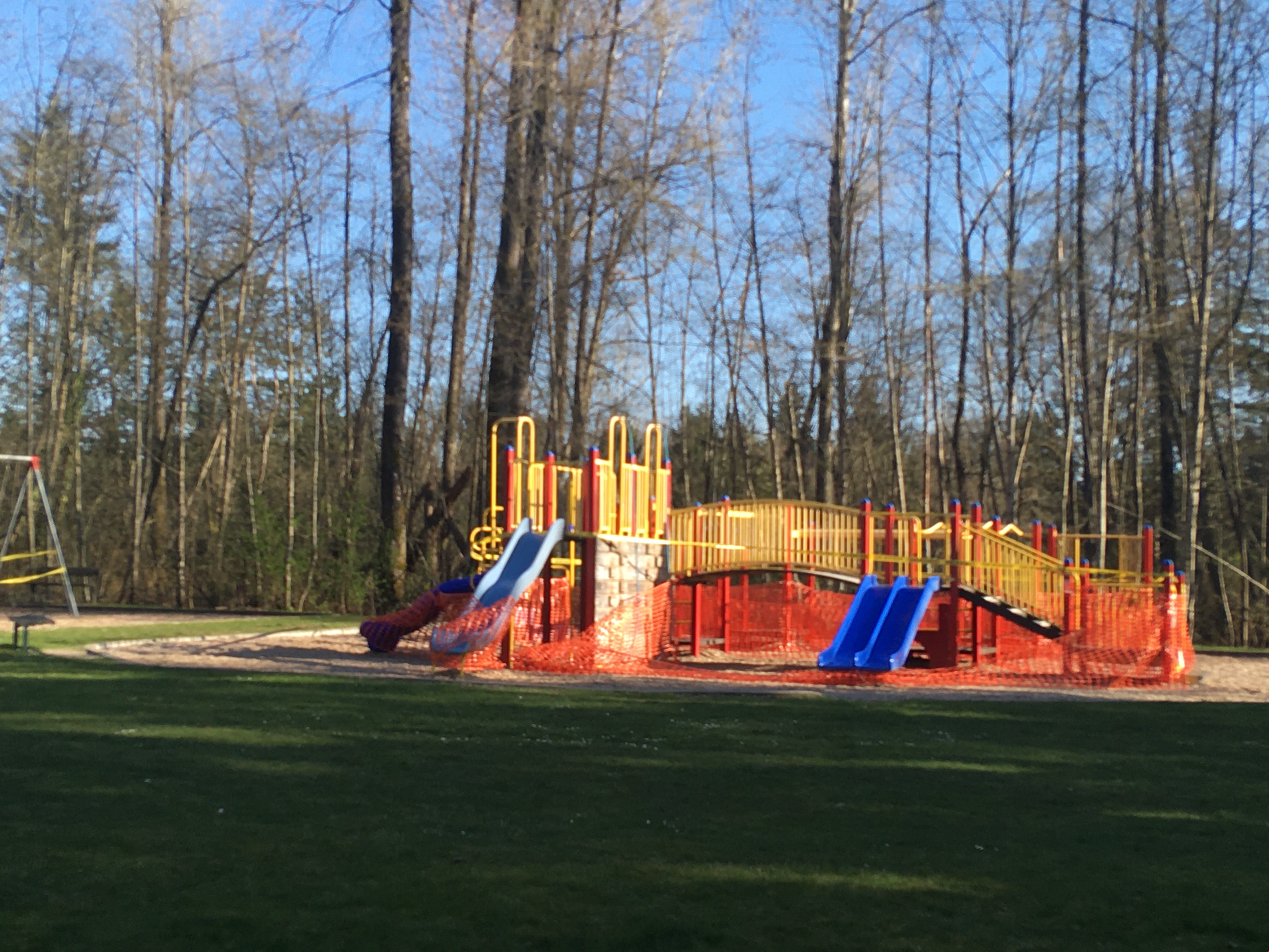
Playground in Squint Lake Park
https://search.heritageburnaby.ca/link/museumdescription14736
- Repository
- Burnaby Village Museum
- Date
- 9 Apr. 2020
- Collection/Fonds
- Burnaby Village Museum COVID-19 collection
- Description Level
- Item
- Physical Description
- 1 photograph (jpg) : col. ; 72 dpi.
- Scope and Content
- Photograph of the Squint Lake Park playground. The playground equipment is surrounded by orange construction fencing to prevent childlren from playing on it. The playground was closed down by the City of Burnaby in the spring of 2020 due to the COVID-19 pandemic and public health orders.
- Repository
- Burnaby Village Museum
- Collection/Fonds
- Burnaby Village Museum COVID-19 collection
- Description Level
- Item
- Physical Description
- 1 photograph (jpg) : col. ; 72 dpi.
- Scope and Content
- Photograph of the Squint Lake Park playground. The playground equipment is surrounded by orange construction fencing to prevent childlren from playing on it. The playground was closed down by the City of Burnaby in the spring of 2020 due to the COVID-19 pandemic and public health orders.
- History
- Tristan Johnson took photos around Burnaby because as a parent of two elementary school aged children during the COVID-19 pandemic, one of the most notable things about COVID-19 during Spring 2020 was the closure of playgrounds and the playgrounds being taped up.
- Accession Code
- BV020.21.1
- Access Restriction
- No restrictions
- Reproduction Restriction
- No known restrictions
- Date
- 9 Apr. 2020
- Media Type
- Photograph
- Planning Study Area
- Sperling-Broadway Area
- Photographer
- Johnson, Tristan
- Notes
- Title based on contents of photograph
Images