More like 'Man in the park'
Narrow Results By
Subject
- Accidents 1
- Accidents - Automobile Accidents 1
- Advertising Medium - Signs and Signboards 37
- Aerial Photographs 36
- Agricultural Tools and Equipment 2
- Agricultural Tools and Equipment - Gardening Equipment 4
- Agricultural Tools and Equipment - Plows 2
- Agriculture 3
- Agriculture - Farms 12
- Agriculture - Fruit and Berries 2
- Animals 4
- Animals - Bears 2
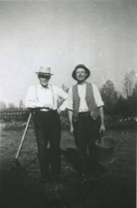
Mr. Boyd and Henry Brawn
https://search.heritageburnaby.ca/link/archivedescription36977
- Repository
- City of Burnaby Archives
- Date
- 1941 (date of original), copied 1992
- Collection/Fonds
- Burnaby Historical Society fonds
- Description Level
- Item
- Physical Description
- 1 photograph : b&w ; 8.1 x 12.7 cm print
- Scope and Content
- Photograph of two neighbours, Mr. Boyd and Henry Brawn, standing in a field.
- Repository
- City of Burnaby Archives
- Date
- 1941 (date of original), copied 1992
- Collection/Fonds
- Burnaby Historical Society fonds
- Subseries
- Burnaby Centennial Anthology subseries
- Physical Description
- 1 photograph : b&w ; 8.1 x 12.7 cm print
- Description Level
- Item
- Record No.
- 315-435
- Access Restriction
- No restrictions
- Reproduction Restriction
- No known restrictions
- Accession Number
- BHS1994-04
- Scope and Content
- Photograph of two neighbours, Mr. Boyd and Henry Brawn, standing in a field.
- Subjects
- Geographic Features - Fields
- Names
- Brawn, Henry
- Media Type
- Photograph
- Notes
- Title based on caption on photograph
Images

![Mr. Manuel with a plough, [192-] (date of original), copied 1991 thumbnail](/media/hpo/_Data/_Archives_Images/_Unrestricted/370/370-100.jpg?width=280)
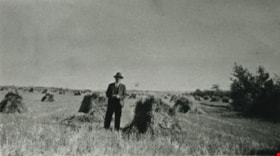
Mr. Manuel with a plough
https://search.heritageburnaby.ca/link/archivedescription37512
- Repository
- City of Burnaby Archives
- Date
- [192-] (date of original), copied 1991
- Collection/Fonds
- Burnaby Historical Society fonds
- Description Level
- Item
- Physical Description
- 1 photograph : b&w ; 3.1 x 5.3 cm print on contact sheet 20.3 x 25.3 cm
- Scope and Content
- Photograph of Mr. Manuel working a plough pulled by two horses at Cassie Avenue (later the location of Metrotown).
- Repository
- City of Burnaby Archives
- Date
- [192-] (date of original), copied 1991
- Collection/Fonds
- Burnaby Historical Society fonds
- Subseries
- Burnaby Image Bank subseries
- Physical Description
- 1 photograph : b&w ; 3.1 x 5.3 cm print on contact sheet 20.3 x 25.3 cm
- Description Level
- Item
- Record No.
- 370-100
- Access Restriction
- No restrictions
- Reproduction Restriction
- No known restrictions
- Accession Number
- BHS1999-03
- Scope and Content
- Photograph of Mr. Manuel working a plough pulled by two horses at Cassie Avenue (later the location of Metrotown).
- Subjects
- Geographic Features - Fields
- Transportation - Horses
- Agricultural Tools and Equipment - Plows
- Occupations - Farmers
- Media Type
- Photograph
- Notes
- Title based on contents of photograph
- 1 b&w copy negative accompanying
- Geographic Access
- Cassie Avenue
- Historic Neighbourhood
- Central Park (Historic Neighbourhood)
- Planning Study Area
- Maywood Area
Images
![Mr. Manuel with a plough, [192-] (date of original), copied 1991 thumbnail](/media/hpo/_Data/_Archives_Images/_Unrestricted/370/370-100.jpg)
![New Burnaby Lake Sports Complex fields, [1999] thumbnail](/media/hpo/_Data/_Archives_Images/_Unrestricted/535/535-3380.jpg?width=280)
New Burnaby Lake Sports Complex fields
https://search.heritageburnaby.ca/link/archivedescription98370
- Repository
- City of Burnaby Archives
- Date
- [1999]
- Collection/Fonds
- Burnaby NewsLeader photograph collection
- Description Level
- Item
- Physical Description
- 1 photograph (tiff) : col.
- Scope and Content
- Photograph of an unidentified worker driving a tractor over one of the new artificial turf sports fields at the Burnaby Lake Sports Complex in advance of the new fields' opening day.
- Repository
- City of Burnaby Archives
- Date
- [1999]
- Collection/Fonds
- Burnaby NewsLeader photograph collection
- Physical Description
- 1 photograph (tiff) : col.
- Description Level
- Item
- Record No.
- 535-3380
- Access Restriction
- No restrictions
- Reproduction Restriction
- No restrictions
- Accession Number
- 2018-12
- Scope and Content
- Photograph of an unidentified worker driving a tractor over one of the new artificial turf sports fields at the Burnaby Lake Sports Complex in advance of the new fields' opening day.
- Subjects
- Geographic Features - Athletic Fields
- Buildings - Recreational - Sports
- Occupations - Civic Workers
- Media Type
- Photograph
- Photographer
- Bartel, Mario
- Notes
- Title based on caption
- Collected by editorial for use in an October 1999 issue of the Burnaby NewsLeader
- Caption from metadata: "Workers are putting the final touches to the new artificial sports fields at Burnaby Lake, in preparation for their official opening on Saturday."
- Geographic Access
- Burnaby Lake Sports Complex
- Kensington Avenue
- Historic Neighbourhood
- Burnaby Lake (Historic Neighbourhood)
- Planning Study Area
- Ardingley-Sprott Area
Images
![New Burnaby Lake Sports Complex fields, [1999] thumbnail](/media/hpo/_Data/_Archives_Images/_Unrestricted/535/535-3380.jpg)
![O.G. Naud house, [1908] (date of original), copied 1986 thumbnail](/media/hpo/_Data/_Archives_Images/_Unrestricted/126/172-002-003.jpg?width=280)
O.G. Naud house
https://search.heritageburnaby.ca/link/archivedescription39832
- Repository
- City of Burnaby Archives
- Date
- [1908] (date of original), copied 1986
- Collection/Fonds
- Burnaby Historical Society fonds
- Description Level
- Item
- Physical Description
- 1 photograph : b&w ; 8.8 x 12.5 cm print
- Scope and Content
- Photograph is the right side of a three-part panorama (photos 172-002a to 172-002c) showing the land beside the house of Onezime G. Naud at 4737 Victory Road (later renamed Victory Street). A number of adults and children are seen standing in a field.
- Repository
- City of Burnaby Archives
- Date
- [1908] (date of original), copied 1986
- Collection/Fonds
- Burnaby Historical Society fonds
- Subseries
- O.G. Naud subseries
- Physical Description
- 1 photograph : b&w ; 8.8 x 12.5 cm print
- Description Level
- Item
- Record No.
- 172-002-3
- Access Restriction
- No restrictions
- Reproduction Restriction
- No known restrictions
- Accession Number
- BHS1986-21
- Scope and Content
- Photograph is the right side of a three-part panorama (photos 172-002a to 172-002c) showing the land beside the house of Onezime G. Naud at 4737 Victory Road (later renamed Victory Street). A number of adults and children are seen standing in a field.
- Media Type
- Photograph
- Notes
- Title based on contents of photograph
- b&w ; 5.5 x 24.5 cm photocopy of entire panorama accompanying in accession file
- Geographic Access
- Victory Street
- Street Address
- 4737 Victory Street
- Historic Neighbourhood
- Alta-Vista (Historic Neighbourhood)
- Planning Study Area
- Sussex-Nelson Area
Images
![O.G. Naud house, [1908] (date of original), copied 1986 thumbnail](/media/hpo/_Data/_Archives_Images/_Unrestricted/126/172-002-003.jpg)
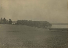
Saskatchewan
https://search.heritageburnaby.ca/link/archivedescription35190
- Repository
- City of Burnaby Archives
- Date
- 1926 (date of original), copied 1986
- Collection/Fonds
- Burnaby Historical Society fonds
- Description Level
- Item
- Physical Description
- 1 photograph : b&w ; 12.7 x 17.8 cm print
- Scope and Content
- Photograph of George Pearson bidding farewell to fields and life on the Prairies.
- Repository
- City of Burnaby Archives
- Date
- 1926 (date of original), copied 1986
- Collection/Fonds
- Burnaby Historical Society fonds
- Subseries
- Pioneer Tales subseries
- Physical Description
- 1 photograph : b&w ; 12.7 x 17.8 cm print
- Description Level
- Item
- Record No.
- 204-047
- Access Restriction
- No restrictions
- Reproduction Restriction
- No known restrictions
- Accession Number
- BHS1988-03
- Scope and Content
- Photograph of George Pearson bidding farewell to fields and life on the Prairies.
- Subjects
- Geographic Features - Fields
- Names
- Pearson, George
- Media Type
- Photograph
- Notes
- Title based on contents of photograph
Images

![SFU Terry Fox Field running track, [2001] thumbnail](/media/hpo/_Data/_Archives_Images/_Unrestricted/535/535-2847.jpg?width=280)
SFU Terry Fox Field running track
https://search.heritageburnaby.ca/link/archivedescription97508
- Repository
- City of Burnaby Archives
- Date
- [2001]
- Collection/Fonds
- Burnaby NewsLeader photograph collection
- Description Level
- Item
- Physical Description
- 1 photograph (tiff) : col.
- Scope and Content
- Photograph of an unidentified person painting the lane markers on the running track at Terry Fox Field at Simon Fraser University.
- Repository
- City of Burnaby Archives
- Date
- [2001]
- Collection/Fonds
- Burnaby NewsLeader photograph collection
- Physical Description
- 1 photograph (tiff) : col.
- Description Level
- Item
- Record No.
- 535-2847
- Access Restriction
- No restrictions
- Reproduction Restriction
- No restrictions
- Accession Number
- 2018-12
- Scope and Content
- Photograph of an unidentified person painting the lane markers on the running track at Terry Fox Field at Simon Fraser University.
- Subjects
- Geographic Features - Athletic Fields
- Buildings - Schools - Universities and Colleges
- Buildings - Recreational - Sports
- Names
- Simon Fraser University
- Media Type
- Photograph
- Photographer
- Bartel, Mario
- Notes
- Title based on caption
- Collected by editorial for use in a September 2001 issue of the Burnaby NewsLeader
- Caption from metadata: "The newly-rebuilt running track at Terry Fox Field at Simon Fraser University finally earns its stripes as a worker paints the lane markers."
- Geographic Access
- Burnaby Mountain Conservation Area
- University Drive
- Street Address
- 8888 University Drive
- Planning Study Area
- Burnaby Mountain Area
Images
![SFU Terry Fox Field running track, [2001] thumbnail](/media/hpo/_Data/_Archives_Images/_Unrestricted/535/535-2847.jpg)
![SFU Terry Fox Run, [2001] thumbnail](/media/hpo/_Data/_Archives_Images/_Unrestricted/535/535-2849.jpg?width=280)
SFU Terry Fox Run
https://search.heritageburnaby.ca/link/archivedescription97510
- Repository
- City of Burnaby Archives
- Date
- [2001]
- Collection/Fonds
- Burnaby NewsLeader photograph collection
- Description Level
- Item
- Physical Description
- 1 photograph (tiff) : col.
- Scope and Content
- Photograph of Simon Fraser University students and staff walking on the Terry Fox Field running track, next to the SFU gymnasium, during the university's Terry Fox Run.
- Repository
- City of Burnaby Archives
- Date
- [2001]
- Collection/Fonds
- Burnaby NewsLeader photograph collection
- Physical Description
- 1 photograph (tiff) : col.
- Description Level
- Item
- Record No.
- 535-2849
- Access Restriction
- No restrictions
- Reproduction Restriction
- No restrictions
- Accession Number
- 2018-12
- Scope and Content
- Photograph of Simon Fraser University students and staff walking on the Terry Fox Field running track, next to the SFU gymnasium, during the university's Terry Fox Run.
- Subjects
- Persons - Students
- Events - Fundraising
- Buildings - Schools - Universities and Colleges
- Geographic Features - Athletic Fields
- Names
- Simon Fraser University
- Media Type
- Photograph
- Photographer
- Bartel, Mario
- Notes
- Title based on caption
- Collected by editorial for use in a September 2001 issue of the Burnaby NewsLeader
- Caption from metadata: "Students, staff and faculty at Simon Fraser University honor the spirit of Terry Fox at their own Terry Fox Run on Wednesday. The University, where Fox was a student before he embarked on his cross-country journey, also unveiled a new statue of Fox, in the Academic Quadrangle."
- Geographic Access
- Burnaby Mountain Conservation Area
- University Drive
- Street Address
- 8888 University Drive
- Planning Study Area
- Burnaby Mountain Area
Images
![SFU Terry Fox Run, [2001] thumbnail](/media/hpo/_Data/_Archives_Images/_Unrestricted/535/535-2849.jpg)
Soccer game at Capitol Hill
https://search.heritageburnaby.ca/link/archivedescription38204
- Repository
- City of Burnaby Archives
- Date
- September 26, 1987 (date of original), copied 1991
- Collection/Fonds
- Burnaby Historical Society fonds
- Description Level
- Item
- Physical Description
- 1 photograph : b&w ; 3.3 x 4.9 cm print on contact sheet 20.3 x 26.6 cm
- Scope and Content
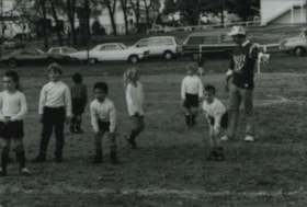
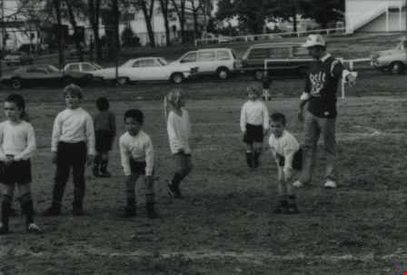
- Photograph of children playing the first soccer game of the season at Capitol Hill, the Aztecs (in white shirts) vs. the Timbers. Left to right: Ryan, Jonathan, Marvin, Tiffany, Jason Foxon, and Morgan. The coach is Chris Foxon. Cars can be seen in the background.
- Repository
- City of Burnaby Archives
- Date
- September 26, 1987 (date of original), copied 1991
- Collection/Fonds
- Burnaby Historical Society fonds
- Subseries
- Burnaby Image Bank subseries
- Physical Description
- 1 photograph : b&w ; 3.3 x 4.9 cm print on contact sheet 20.3 x 26.6 cm
- Description Level
- Item
- Record No.
- 370-791
- Access Restriction
- No restrictions
- Reproduction Restriction
- No restrictions
- Accession Number
- BHS1999-03
- Scope and Content
- Photograph of children playing the first soccer game of the season at Capitol Hill, the Aztecs (in white shirts) vs. the Timbers. Left to right: Ryan, Jonathan, Marvin, Tiffany, Jason Foxon, and Morgan. The coach is Chris Foxon. Cars can be seen in the background.
- Names
- Foxon, Chris
- Foxon, Jason
- Media Type
- Photograph
- Notes
- Title based on contents of photograph
- 1 b&w copy negative accompanying
- Copied from col. photograph
- Historic Neighbourhood
- Capitol Hill (Historic Neighbourhood)
- Planning Study Area
- Capitol Hill Area
Images
![Sperling Avenue and Douglas Road, [1937 or 1938] (date of original), copied 1991 thumbnail](/media/hpo/_Data/_Archives_Images/_Unrestricted/370/370-537.jpg?width=280)
Sperling Avenue and Douglas Road
https://search.heritageburnaby.ca/link/archivedescription37950
- Repository
- City of Burnaby Archives
- Date
- [1937 or 1938] (date of original), copied 1991
- Collection/Fonds
- Burnaby Historical Society fonds
- Description Level
- Item
- Physical Description
- 1 photograph : b&w ; 2.7 x 3.8 cm print on contact sheet 20.6 x 26.1 cm
- Scope and Content
- Photograph of the Sperling Avenue and Douglas Road area.
- Repository
- City of Burnaby Archives
- Date
- [1937 or 1938] (date of original), copied 1991
- Collection/Fonds
- Burnaby Historical Society fonds
- Subseries
- Burnaby Image Bank subseries
- Physical Description
- 1 photograph : b&w ; 2.7 x 3.8 cm print on contact sheet 20.6 x 26.1 cm
- Description Level
- Item
- Record No.
- 370-537
- Access Restriction
- No restrictions
- Reproduction Restriction
- No known restrictions
- Accession Number
- BHS1999-03
- Scope and Content
- Photograph of the Sperling Avenue and Douglas Road area.
- Subjects
- Geographic Features - Fields
- Media Type
- Photograph
- Notes
- Title based on contents of photograph
- 1 b&w copy negative accompanying
- Geographic Access
- Douglas Road
- Sperling Avenue
- Canada Way
- Historic Neighbourhood
- Burnaby Lake (Historic Neighbourhood)
- Planning Study Area
- Morley-Buckingham Area
Images
![Sperling Avenue and Douglas Road, [1937 or 1938] (date of original), copied 1991 thumbnail](/media/hpo/_Data/_Archives_Images/_Unrestricted/370/370-537.jpg)
Steers' Home Near Medford, Oregon
https://search.heritageburnaby.ca/link/archivedescription39508
- Repository
- City of Burnaby Archives
- Date
- 1881
- Collection/Fonds
- Peers Family and Hill Family fonds
- Description Level
- Item
- Physical Description
- 1 photograph : sepia ; 10 x 14 cm on page 21.5 x 28 cm (pasted in album)
- Scope and Content
- Photograph of the home and property belonging to Mr. and Mrs. Steers, Oregon USA. Prior to moving to Canada, Claude Hill (an early resident of Burnaby Lake) lived and worked in Oregon for the Steers family.
- Repository
- City of Burnaby Archives
- Date
- 1881
- Collection/Fonds
- Peers Family and Hill Family fonds
- Physical Description
- 1 photograph : sepia ; 10 x 14 cm on page 21.5 x 28 cm (pasted in album)
- Description Level
- Item
- Record No.
- 477-827
- Access Restriction
- No restrictions
- Reproduction Restriction
- No known restrictions
- Accession Number
- 2007-12
- Scope and Content
- Photograph of the home and property belonging to Mr. and Mrs. Steers, Oregon USA. Prior to moving to Canada, Claude Hill (an early resident of Burnaby Lake) lived and worked in Oregon for the Steers family.
- Subjects
- Geographic Features - Fields
- Media Type
- Photograph
- Notes
- Title based on caption accompanying photograph
Images


Swangard Stadium closed
https://search.heritageburnaby.ca/link/archivedescription95096
- Repository
- City of Burnaby Archives
- Date
- April 21, 2020
- Collection/Fonds
- Burnaby Photographic Society fonds
- Description Level
- Item
- Physical Description
- 1 photograph (tiff)
- Scope and Content
- Photograph of two City of Burnaby signs attached to fencing outside Swangard Stadium in Central Park. The signs announce the facility's closure in response to the COVID-19 pandemic. Behind the fencing, the stadium's track and bleachers are visible.
- Repository
- City of Burnaby Archives
- Date
- April 21, 2020
- Collection/Fonds
- Burnaby Photographic Society fonds
- Physical Description
- 1 photograph (tiff)
- Description Level
- Item
- Record No.
- 623-015
- Access Restriction
- No restrictions
- Reproduction Restriction
- No restrictions
- Accession Number
- 2020-10
- Scope and Content
- Photograph of two City of Burnaby signs attached to fencing outside Swangard Stadium in Central Park. The signs announce the facility's closure in response to the COVID-19 pandemic. Behind the fencing, the stadium's track and bleachers are visible.
- Names
- Swangard Stadium
- Media Type
- Photograph
- Photographer
- Damer, Eric
- Notes
- Transcribed title
- Geographic Access
- Central Park
- Imperial Street
- Street Address
- 3883 Imperial Street
- Historic Neighbourhood
- Central Park (Historic Neighbourhood)
- Planning Study Area
- Maywood Area
Images

7837 CA Way Burnaby
https://search.heritageburnaby.ca/link/archivedescription93813
- Repository
- City of Burnaby Archives
- Date
- November 1992
- Collection/Fonds
- Grover, Elliott & Co. Ltd. fonds
- Description Level
- File
- Physical Description
- 48 photographs : col. negatives ; 35 mm + 5 photographs : col. ; 10 cm x 15 cm
- Scope and Content
- Photographs of the residential buildings located at 7837 Canada Way. Buildings include a two-storey blue-shingled house, single-storey addition, and a guest house. File also contains photographs of the Capilano suspension bridge and Capilano Suspension Bridge Park in North Vancouver.
- Repository
- City of Burnaby Archives
- Date
- November 1992
- Collection/Fonds
- Grover, Elliott & Co. Ltd. fonds
- Physical Description
- 48 photographs : col. negatives ; 35 mm + 5 photographs : col. ; 10 cm x 15 cm
- Description Level
- File
- Record No.
- 622-061
- Access Restriction
- No restrictions
- Reproduction Restriction
- No restrictions
- Accession Number
- 2017-39
- Scope and Content
- Photographs of the residential buildings located at 7837 Canada Way. Buildings include a two-storey blue-shingled house, single-storey addition, and a guest house. File also contains photographs of the Capilano suspension bridge and Capilano Suspension Bridge Park in North Vancouver.
- Media Type
- Photograph
- Notes
- Transcribed title
- Title transcribed from envelope photographs were originally housed in
- File no. 92-437-B
- Sticky note adhered to 622-061-9 print reads: "7 / View of the building looking northeast across the site".
- Sticky note adhered to 622-061-13 print reads: "6 / View of the original house and the single storey addition looking north west across the property".
- Sticky note adhered to 622-061-17 print reads: "8 / View northeast across the property from the southeast corner".
- Sticky note adhered to 622-061-21 print reads: "9 / View west from the property along the lane at the south side".
- Sticky note adhered to 622-061-26 reads: "3 / The original house now part of the guest home and the view south along the east property line".
- Sticky note adhered to 622-061-27 reads: "4 / View west along Canada Way [illegible] the subject".
- Sticky note adhered to 622-061-28 reads: "5 / The most recent addition - the single storey L shaped structure at the west end of the guesthouse".
- Sticky note adhere to 622-061-29 reads: "5A / The original house"."
- Photographer identified as "D.E."
- Geographic Access
- Canada Way
- Street Address
- 7837 Canada Way
- Planning Study Area
- Lake City Area
![Aftermath of a snowfall, [1999] thumbnail](/media/hpo/_Data/_Archives_Images/_Unrestricted/535/535-3125-1.jpg?width=280)
Aftermath of a snowfall
https://search.heritageburnaby.ca/link/archivedescription98045
- Repository
- City of Burnaby Archives
- Date
- [1999]
- Collection/Fonds
- Burnaby NewsLeader photograph collection
- Description Level
- File
- Physical Description
- 4 photographs (tiff) : b&w
- Scope and Content
- File contains photographs of the aftermath of a large snowfall. Photographs depict an unidentified person moving snow with a wheelbarrow; people shovelling out cars stuck on roads in the snow; and a crane and snow-covered park.
- Repository
- City of Burnaby Archives
- Date
- [1999]
- Collection/Fonds
- Burnaby NewsLeader photograph collection
- Physical Description
- 4 photographs (tiff) : b&w
- Description Level
- File
- Record No.
- 535-3125
- Access Restriction
- No restrictions
- Reproduction Restriction
- No restrictions
- Accession Number
- 2018-12
- Scope and Content
- File contains photographs of the aftermath of a large snowfall. Photographs depict an unidentified person moving snow with a wheelbarrow; people shovelling out cars stuck on roads in the snow; and a crane and snow-covered park.
- Subjects
- Natural Phenomena - Snow
- Geographic Features - Parks
- Geographic Features - Roads
- Transportation - Automobiles
- Media Type
- Photograph
- Notes
- Title based on contents of file
- Collected by editorial for use in a February 1999 issue of the Burnaby NewsLeader
Images
![Aftermath of a snowfall, [1999] thumbnail](/media/hpo/_Data/_Archives_Images/_Unrestricted/535/535-3125-1.jpg)
![Burnaby Fraser Foreshore Park, [2000] thumbnail](/media/hpo/_Data/_Archives_Images/_Unrestricted/535/535-2524-1.jpg?width=280)
Burnaby Fraser Foreshore Park
https://search.heritageburnaby.ca/link/archivedescription96970
- Repository
- City of Burnaby Archives
- Date
- [2000]
- Collection/Fonds
- Burnaby NewsLeader photograph collection
- Description Level
- File
- Physical Description
- 2 photographs (tiff) : col.
- Scope and Content
- File contains photographs of Mayor Doug Drummond and another unidentified person posing by the Fraser River in Burnaby Fraser Foreshore Park.
- Repository
- City of Burnaby Archives
- Date
- [2000]
- Collection/Fonds
- Burnaby NewsLeader photograph collection
- Physical Description
- 2 photographs (tiff) : col.
- Description Level
- File
- Record No.
- 535-2524
- Access Restriction
- No restrictions
- Reproduction Restriction
- No restrictions
- Accession Number
- 2018-12
- Scope and Content
- File contains photographs of Mayor Doug Drummond and another unidentified person posing by the Fraser River in Burnaby Fraser Foreshore Park.
- Media Type
- Photograph
- Notes
- Title based on original file name
- Collected by editorial for use in a June 2000 issue of the Burnaby NewsLeader
- Geographic Access
- Burnaby Fraser Foreshore Park
- Historic Neighbourhood
- Fraser Arm (Historic Neighbourhood)
- Planning Study Area
- Big Bend Area
Images
![Burnaby Fraser Foreshore Park, [2000] thumbnail](/media/hpo/_Data/_Archives_Images/_Unrestricted/535/535-2524-1.jpg)

Burnaby Mountain Parking Lot & Restaurant
https://search.heritageburnaby.ca/link/archivedescription93706
- Repository
- City of Burnaby Archives
- Date
- February 15, 1978
- Collection/Fonds
- Burnaby Public Library Contemporary Visual Archive Project
- Description Level
- Item
- Physical Description
- 1 photograph : b&w ; 12.5 x 17.5 cm
- Scope and Content
- Photograph of the view of the mountains and park from a hill on Burnaby Mountain Park. The photograph is taken facing north. The photograph shows the parking lot and the Burnaby Mountain Centennial Pavilion.
- Repository
- City of Burnaby Archives
- Date
- February 15, 1978
- Collection/Fonds
- Burnaby Public Library Contemporary Visual Archive Project
- Physical Description
- 1 photograph : b&w ; 12.5 x 17.5 cm
- Description Level
- Item
- Record No.
- 556-663
- Access Restriction
- No restrictions
- Reproduction Restriction
- Reproduce for fair dealing purposes only
- Accession Number
- 2017-57
- Scope and Content
- Photograph of the view of the mountains and park from a hill on Burnaby Mountain Park. The photograph is taken facing north. The photograph shows the parking lot and the Burnaby Mountain Centennial Pavilion.
- Subjects
- Buildings - Commercial - Restaurants
- Buildings - Civic
- Buildings - Recreational
- Geographic Features - Automobile Parking Lots
- Geographic Features - Parks
- Names
- Burnaby Mountain Park
- Media Type
- Photograph
- Photographer
- Surridge, Jack
- Notes
- Title taken from project information form
- Accompanied by a project information form and 1 photograph (b&w negative ; 9.5 x 12.5 cm)
- BPL no. 111
- Geographic Access
- Burnaby Lake Regional Nature Park
- Burnaby Mountain Conservation Area
- Street Address
- 100 Centennial Way
- Planning Study Area
- Burnaby Mountain Area
Images


Burnaby Park
https://search.heritageburnaby.ca/link/archivedescription34577
- Repository
- City of Burnaby Archives
- Date
- 1927
- Collection/Fonds
- Burnaby Historical Society fonds
- Description Level
- Item
- Physical Description
- 1 photograph : b&w ; 34.5 x 23.3 cm mounted on 49.5 x 35.1 cm cardboard
- Scope and Content
- Photograph taken from Burnaby Park, including trees and mountains in the distance.
- Repository
- City of Burnaby Archives
- Date
- 1927
- Collection/Fonds
- Burnaby Historical Society fonds
- Subseries
- Photographs subseries
- Physical Description
- 1 photograph : b&w ; 34.5 x 23.3 cm mounted on 49.5 x 35.1 cm cardboard
- Description Level
- Item
- Record No.
- 055-002
- Access Restriction
- No restrictions
- Reproduction Restriction
- No known restrictions
- Accession Number
- BHS2007-04
- Scope and Content
- Photograph taken from Burnaby Park, including trees and mountains in the distance.
- Media Type
- Photograph
- Photographer
- Lloyd's Studio
- Notes
- Title based on contents of photograph
- Annotation on bottom front of cardboard reads, "Burnaby Park / Officially Opened August 6th, 1927"
- Geographic Access
- Robert Burnaby Park
- Wedgewood Street
- Street Address
- 8155 Wedgewood Street
- Historic Neighbourhood
- Burnaby Lake (Historic Neighbourhood)
- Planning Study Area
- Lakeview-Mayfield Area
Images

![Central Park snow, [2001] thumbnail](/media/hpo/_Data/_Archives_Images/_Unrestricted/535/535-1626.jpg?width=280)
Central Park snow
https://search.heritageburnaby.ca/link/archivedescription95794
- Repository
- City of Burnaby Archives
- Date
- [2001]
- Collection/Fonds
- Burnaby NewsLeader photograph collection
- Description Level
- Item
- Physical Description
- 1 photograph (tiff) : col.
- Scope and Content
- Photograph of two people dressed in winter clothing in Central Park. They are walking down a snow-covered path by the pond; it is snowing and the trees and ground are covered in snow. Many ducks are visible in the pond.
- Repository
- City of Burnaby Archives
- Date
- [2001]
- Collection/Fonds
- Burnaby NewsLeader photograph collection
- Physical Description
- 1 photograph (tiff) : col.
- Description Level
- Item
- Record No.
- 535-1626
- Access Restriction
- No restrictions
- Reproduction Restriction
- No restrictions
- Accession Number
- 2018-12
- Scope and Content
- Photograph of two people dressed in winter clothing in Central Park. They are walking down a snow-covered path by the pond; it is snowing and the trees and ground are covered in snow. Many ducks are visible in the pond.
- Media Type
- Photograph
- Photographer
- Bartel, Mario
- Notes
- Title based on caption
- Collected by editorial for use in a February 2001 issue of the Burnaby NewsLeader
- Caption from metadata: "Thursday's snowfall creates a winter wonderland around the duck pond in Burnaby's Central Park."
- Geographic Access
- Central Park
- Imperial Street
- Street Address
- 3883 Imperial Street
- Historic Neighbourhood
- Central Park (Historic Neighbourhood)
- Planning Study Area
- Maywood Area
Images
![Central Park snow, [2001] thumbnail](/media/hpo/_Data/_Archives_Images/_Unrestricted/535/535-1626.jpg)

Central Park testing station
https://search.heritageburnaby.ca/link/archivedescription95101
- Repository
- City of Burnaby Archives
- Date
- May 9, 2020
- Collection/Fonds
- Burnaby Photographic Society fonds
- Description Level
- Item
- Physical Description
- 1 photograph (tiff)
- Scope and Content
- Photograph of the COVID-19 testing station located in the Central Park parking lot off Boundary Road. A sign in the foreground reads "Covid-19 Care Site by Referral Only / Walk in Access". In the background, the white tents of the testing station are visible.
- Repository
- City of Burnaby Archives
- Date
- May 9, 2020
- Collection/Fonds
- Burnaby Photographic Society fonds
- Physical Description
- 1 photograph (tiff)
- Description Level
- Item
- Record No.
- 623-019
- Access Restriction
- No restrictions
- Reproduction Restriction
- No restrictions
- Accession Number
- 2020-10
- Scope and Content
- Photograph of the COVID-19 testing station located in the Central Park parking lot off Boundary Road. A sign in the foreground reads "Covid-19 Care Site by Referral Only / Walk in Access". In the background, the white tents of the testing station are visible.
- Subjects
- Geographic Features - Parks
- Geographic Features - Automobile Parking Lots
- Advertising Medium - Signs and Signboards
- Structures - Tents
- Media Type
- Photograph
- Photographer
- Damer, Eric
- Notes
- Transcribed title
- Geographic Access
- Boundary Road
- Central Park
- Historic Neighbourhood
- Central Park (Historic Neighbourhood)
- Planning Study Area
- Maywood Area
Images

![Daffodils at Kensington Park, [2004] thumbnail](/media/hpo/_Data/_Archives_Images/_Unrestricted/535/535-2087.jpg?width=280)
Daffodils at Kensington Park
https://search.heritageburnaby.ca/link/archivedescription96417
- Repository
- City of Burnaby Archives
- Date
- [2004]
- Collection/Fonds
- Burnaby NewsLeader photograph collection
- Description Level
- Item
- Physical Description
- 1 photograph (tiff) : col.
- Scope and Content
- Photograph of City of Burnaby Parks employee Andrew O'Keeffe tending to a bed of daffodils in bloom at Kensington Park.
- Repository
- City of Burnaby Archives
- Date
- [2004]
- Collection/Fonds
- Burnaby NewsLeader photograph collection
- Physical Description
- 1 photograph (tiff) : col.
- Description Level
- Item
- Record No.
- 535-2087
- Access Restriction
- No restrictions
- Reproduction Restriction
- No restrictions
- Accession Number
- 2018-12
- Scope and Content
- Photograph of City of Burnaby Parks employee Andrew O'Keeffe tending to a bed of daffodils in bloom at Kensington Park.
- Subjects
- Occupations - Civic Workers
- Plants - Flowers
- Geographic Features - Gardens
- Geographic Features - Parks
- Media Type
- Photograph
- Photographer
- Bartel, Mario
- Notes
- Title based on caption
- Collected by editorial for use in a March 2004 issue of the Burnaby NewsLeader
- Caption from metadata: "Andrew O'Keeffe, of the Burnaby Parks and Recreation Department, tends to some of the 2500 daffodils in the gardens of Kensington Park, along Hastings St."
- Geographic Access
- Hastings Street
- Kensington Park
- Historic Neighbourhood
- Lochdale (Historic Neighbourhood)
- Planning Study Area
- Parkcrest-Aubrey Area
Images
![Daffodils at Kensington Park, [2004] thumbnail](/media/hpo/_Data/_Archives_Images/_Unrestricted/535/535-2087.jpg)

Deer Lake parking lot off limits
https://search.heritageburnaby.ca/link/archivedescription95113
- Repository
- City of Burnaby Archives
- Date
- June 26, 2020
- Collection/Fonds
- Burnaby Photographic Society fonds
- Description Level
- Item
- Physical Description
- 1 photograph (tiff)
- Scope and Content
- Photograph of the Deer Lake Park parking lot at the Royal Oak entrance. The entrance to the lot is blocked off with two orange traffic barriers. In the distance, a sign detailing a temporary one-way walking route for the park and a man walking into the park are visible.
- Repository
- City of Burnaby Archives
- Date
- June 26, 2020
- Collection/Fonds
- Burnaby Photographic Society fonds
- Physical Description
- 1 photograph (tiff)
- Description Level
- Item
- Record No.
- 623-031
- Access Restriction
- No restrictions
- Reproduction Restriction
- No restrictions
- Accession Number
- 2020-10
- Scope and Content
- Photograph of the Deer Lake Park parking lot at the Royal Oak entrance. The entrance to the lot is blocked off with two orange traffic barriers. In the distance, a sign detailing a temporary one-way walking route for the park and a man walking into the park are visible.
- Media Type
- Photograph
- Photographer
- Snowdon, Nick
- Notes
- Transcribed title
- Photographer's caption: "Deer Lake parking lots are blocked off for a few months"
- Geographic Access
- Deer Lake Park
- Planning Study Area
- Windsor Area
Images
