More like 'Douglas Road'
Narrow Results By
Subject
- Accidents 1
- Accidents - Automobile Accidents 1
- Advertising Medium - Signs and Signboards 35
- Aerial Photographs 24
- Agricultural Tools and Equipment 2
- Agricultural Tools and Equipment - Gardening Equipment 4
- Agricultural Tools and Equipment - Plows 2
- Agriculture 3
- Agriculture - Farms 12
- Agriculture - Fruit and Berries 1
- Animals 4
- Animals - Birds 29
![Trans Canada Trail, [2000] thumbnail](/media/hpo/_Data/_Archives_Images/_Unrestricted/535/535-2372.jpg?width=280)
Trans Canada Trail
https://search.heritageburnaby.ca/link/archivedescription96814
- Repository
- City of Burnaby Archives
- Date
- [2000]
- Collection/Fonds
- Burnaby NewsLeader photograph collection
- Description Level
- Item
- Physical Description
- 1 photograph (tiff) : b&w
- Scope and Content
- Photograph of an unidentified person and their dog on the Trans Canada Trail in North Burnaby, overlooking the Burrard Inlet. Industrial ports and plants on the North Shore and the North Shore mountains are visible on the other side of the Inlet.
- Repository
- City of Burnaby Archives
- Date
- [2000]
- Collection/Fonds
- Burnaby NewsLeader photograph collection
- Physical Description
- 1 photograph (tiff) : b&w
- Description Level
- Item
- Record No.
- 535-2372
- Access Restriction
- No restrictions
- Reproduction Restriction
- No restrictions
- Accession Number
- 2018-12
- Scope and Content
- Photograph of an unidentified person and their dog on the Trans Canada Trail in North Burnaby, overlooking the Burrard Inlet. Industrial ports and plants on the North Shore and the North Shore mountains are visible on the other side of the Inlet.
- Media Type
- Photograph
- Photographer
- Bartel, Mario
- Notes
- Title based on caption
- Collected by editorial for use in an April 2000 issue of the Burnaby NewsLeader
- Caption from metadata: "The Trans Canada Trail is popular with dog walkers, offering spectacular vistas of Burrard Inlet and the North Shore Mountains."
- Geographic Access
- Burrard Inlet
- Historic Neighbourhood
- Capitol Hill (Historic Neighbourhood)
- Planning Study Area
- Capitol Hill Area
Images
![Trans Canada Trail, [2000] thumbnail](/media/hpo/_Data/_Archives_Images/_Unrestricted/535/535-2372.jpg)
![C.P.R. line, [192-] thumbnail](/media/hpo/_Data/_BVM_Images/2007/2007_0045_0014_001.jpg?width=280)
C.P.R. line
https://search.heritageburnaby.ca/link/museumdescription3898
- Repository
- Burnaby Village Museum
- Date
- [192-]
- Collection/Fonds
- Burnaby Village Museum Photograph collection
- Description Level
- Item
- Physical Description
- 1 photograph : b&w ; 11.5 x 7 cm
- Scope and Content
- Photograph of a trail overlooking Burrard Inlet that runs down a hill through some evergreen trees.
- Repository
- Burnaby Village Museum
- Collection/Fonds
- Burnaby Village Museum Photograph collection
- Description Level
- Item
- Physical Description
- 1 photograph : b&w ; 11.5 x 7 cm
- Material Details
- "You asked me how / far the CPR Line / was from our lot / It is within 1/4 mile / This was taken / right above the / CPR line, there is / quite a sharp descent / from here down to the / line If the piece of / bush to the left was / cut you would see 2nd narrows bridge" written in pencil on the back of the photo.
- Scope and Content
- Photograph of a trail overlooking Burrard Inlet that runs down a hill through some evergreen trees.
- History
- George Vincent Martin was born in 1892 in England. He married Matilda Florence Reed in 1916. He purchased a property in North Burnaby in the 1920s on Trinity Street. There was a main house and a "shack" on the property split up onto two lots.
- Accession Code
- BV007.45.14
- Access Restriction
- No restrictions
- Reproduction Restriction
- No known restrictions
- Date
- [192-]
- Media Type
- Photograph
- Scan Resolution
- 300
- Scan Date
- 29-Nov-2018
- Scale
- 96
- Notes
- Title based on notes on the reverse of the photograph
Images
![C.P.R. line, [192-] thumbnail](/media/hpo/_Data/_BVM_Images/2007/2007_0045_0014_001.jpg)
![Lois Hollands-Coutts and Charles Hollands, [1945] (date of original), copied 1991 thumbnail](/media/hpo/_Data/_Archives_Images/_Unrestricted/370/370-429.jpg?width=280)
Lois Hollands-Coutts and Charles Hollands
https://search.heritageburnaby.ca/link/archivedescription37841
- Repository
- City of Burnaby Archives
- Date
- [1945] (date of original), copied 1991
- Collection/Fonds
- Burnaby Historical Society fonds
- Description Level
- Item
- Physical Description
- 1 photograph : b&w ; 4.1 x 2.8 cm print on contact sheet 20.6 x 26.7 cm
- Scope and Content
- Photograph of Lois Holland-Coutts and her father, Charles Hollands, on a path leading to Robert Burnaby Park, near 6th Street at 19th Avenue.
- Repository
- City of Burnaby Archives
- Date
- [1945] (date of original), copied 1991
- Collection/Fonds
- Burnaby Historical Society fonds
- Subseries
- Burnaby Image Bank subseries
- Physical Description
- 1 photograph : b&w ; 4.1 x 2.8 cm print on contact sheet 20.6 x 26.7 cm
- Description Level
- Item
- Record No.
- 370-429
- Access Restriction
- No restrictions
- Reproduction Restriction
- No known restrictions
- Accession Number
- BHS1999-03
- Scope and Content
- Photograph of Lois Holland-Coutts and her father, Charles Hollands, on a path leading to Robert Burnaby Park, near 6th Street at 19th Avenue.
- Media Type
- Photograph
- Notes
- Title based on contents of photograph
- 1 b&w copy negative accompanying
- Negative has a pink cast
- Geographic Access
- 6th Street
- 19th Avenue
- Historic Neighbourhood
- East Burnaby (Historic Neighbourhood)
- Planning Study Area
- Second Street Area
Images
![Lois Hollands-Coutts and Charles Hollands, [1945] (date of original), copied 1991 thumbnail](/media/hpo/_Data/_Archives_Images/_Unrestricted/370/370-429.jpg)

Trail through the woods of Stoney Creek School
https://search.heritageburnaby.ca/link/archivedescription58924
- Repository
- City of Burnaby Archives
- Date
- ca.1980
- Collection/Fonds
- Columbian Newspaper collection
- Description Level
- Item
- Physical Description
- 1 photograph : b&w ; 25.5 x 20.5 cm
- Scope and Content
- Photograph of a paved trail through the woods by Stoney Creek Community School. A parking lot with cars is visible at the end of the trail.
- Repository
- City of Burnaby Archives
- Date
- ca.1980
- Collection/Fonds
- Columbian Newspaper collection
- Physical Description
- 1 photograph : b&w ; 25.5 x 20.5 cm
- Description Level
- Item
- Record No.
- 480-1375
- Access Restriction
- No restrictions
- Reproduction Restriction
- Reproduce for fair dealing purposes only
- Accession Number
- 2009-01
- Scope and Content
- Photograph of a paved trail through the woods by Stoney Creek Community School. A parking lot with cars is visible at the end of the trail.
- Media Type
- Photograph
- Photographer
- King, Basil
- Notes
- Title based on contents of photograph
- Note on recto reads: "Trail thru woods & Stoney Creek School"
- Note on verso reads: "PMT 100% / page 1 / Burnaby Today"
- Photographer's stamp on verso
- Street Address
- 2740 Beaverbrook Crescent
- Historic Neighbourhood
- Burquitlam (Historic Neighbourhood)
- Planning Study Area
- Lyndhurst Area
Images

![Trail to Shell installation, [1911] thumbnail](/media/hpo/_Data/_Archives_Images/_Unrestricted/204/204-711.jpg?width=280)
Trail to Shell installation
https://search.heritageburnaby.ca/link/archivedescription35852
- Repository
- City of Burnaby Archives
- Date
- [1911]
- Collection/Fonds
- Burnaby Historical Society fonds
- Description Level
- Item
- Physical Description
- 1 photograph : b&w ; 12.7 x 17.8 cm print
- Scope and Content
- Photograph of the trail to the powder magazine wharf at the Shell installation. Fred Holmes and his friends would catch crabs from the wharf, where dynamite was stored at end of the pier in a shack (thus its name).
- Repository
- City of Burnaby Archives
- Date
- [1911]
- Collection/Fonds
- Burnaby Historical Society fonds
- Subseries
- Pioneer Tales subseries
- Physical Description
- 1 photograph : b&w ; 12.7 x 17.8 cm print
- Description Level
- Item
- Record No.
- 204-711
- Access Restriction
- No restrictions
- Reproduction Restriction
- No known restrictions
- Accession Number
- BHS1988-03
- Scope and Content
- Photograph of the trail to the powder magazine wharf at the Shell installation. Fred Holmes and his friends would catch crabs from the wharf, where dynamite was stored at end of the pier in a shack (thus its name).
- Media Type
- Photograph
- Photographer
- Phillips, James William "Jim"
- Notes
- Title based on contents of photograph
- Geographic Access
- Barnet Road
- Street Address
- 7790 Barnet Road
- Planning Study Area
- Westridge Area
Images
![Trail to Shell installation, [1911] thumbnail](/media/hpo/_Data/_Archives_Images/_Unrestricted/204/204-711.jpg)
![Trans Canada Trail in North Burnaby, [2000] thumbnail](/media/hpo/_Data/_Archives_Images/_Unrestricted/535/535-2117-1.jpg?width=280)
Trans Canada Trail in North Burnaby
https://search.heritageburnaby.ca/link/archivedescription96493
- Repository
- City of Burnaby Archives
- Date
- [2000]
- Collection/Fonds
- Burnaby NewsLeader photograph collection
- Description Level
- File
- Physical Description
- 2 photographs (tiff) : col.
- Scope and Content
- File contains photographs of Ruth Hardy, Anita Loy, and Trudy Mile walking the Trans Canada Trail in North Burnaby. Photographs depict them enjoying a view of the Burrard Inlet from the Heights Trail leg and walking past a trail marker that reads: "The Heights Trail."
- Repository
- City of Burnaby Archives
- Date
- [2000]
- Collection/Fonds
- Burnaby NewsLeader photograph collection
- Physical Description
- 2 photographs (tiff) : col.
- Description Level
- File
- Record No.
- 535-2117
- Access Restriction
- No restrictions
- Reproduction Restriction
- No restrictions
- Accession Number
- 2018-12
- Scope and Content
- File contains photographs of Ruth Hardy, Anita Loy, and Trudy Mile walking the Trans Canada Trail in North Burnaby. Photographs depict them enjoying a view of the Burrard Inlet from the Heights Trail leg and walking past a trail marker that reads: "The Heights Trail."
- Media Type
- Photograph
- Photographer
- Bartel, Mario
- Notes
- Title based on caption
- Collected by editorial for use in a March 2000 issue of the Burnaby NewsLeader
- Caption from metadata for 535-2117-1: "Ruth Hardy, Anita Loy and Trudy Mile enjoy some of the views along the Heights Trail leg of the Trans Canada Trail, as it winds along Burrard Inlet."
- Caption from metadata for 535-2117-2: "Ruth Hardy, Trudy Mile and Anita Loy get a little exercise along the Trans Canada Trail as it winds through North Burnaby."
- Geographic Access
- Burrard Inlet
- Burnaby Heights Park
- Historic Neighbourhood
- Vancouver Heights (Historic Neighbourhood)
- Planning Study Area
- Burnaby Heights Area
Images
![Trans Canada Trail in North Burnaby, [2000] thumbnail](/media/hpo/_Data/_Archives_Images/_Unrestricted/535/535-2117-1.jpg)
![Big Brothers, [2000] thumbnail](/media/hpo/_Data/_Archives_Images/_Unrestricted/535/535-2151.jpg?width=280)
Big Brothers
https://search.heritageburnaby.ca/link/archivedescription96527
- Repository
- City of Burnaby Archives
- Date
- [2000]
- Collection/Fonds
- Burnaby NewsLeader photograph collection
- Description Level
- Item
- Physical Description
- 1 photograph (tiff) : col.
- Scope and Content
- Photograph of Mark Forward, with Big Brothers, walking along a forest trail with his Little Brother, Andrew.
- Repository
- City of Burnaby Archives
- Date
- [2000]
- Collection/Fonds
- Burnaby NewsLeader photograph collection
- Physical Description
- 1 photograph (tiff) : col.
- Description Level
- Item
- Record No.
- 535-2151
- Access Restriction
- No restrictions
- Reproduction Restriction
- No restrictions
- Accession Number
- 2018-12
- Scope and Content
- Photograph of Mark Forward, with Big Brothers, walking along a forest trail with his Little Brother, Andrew.
- Media Type
- Photograph
- Photographer
- Bartel, Mario
- Notes
- Title based on caption
- Collected by editorial for use in an April 2000 issue of the Burnaby NewsLeader
- Caption from metadata: "Mark Forward tries to spend as much of his time with his Little Brother, Andrew, doing outdoor activities, like hiking."
Images
![Big Brothers, [2000] thumbnail](/media/hpo/_Data/_Archives_Images/_Unrestricted/535/535-2151.jpg)
![Bridge and trail in Robert Burnaby Park, [between 1933 and 1947] (date of original), copied 2014 thumbnail](/media/hpo/_Data/_Archives_Images/_Unrestricted/580/581-012.jpg?width=280)
Bridge and trail in Robert Burnaby Park
https://search.heritageburnaby.ca/link/archivedescription88406
- Repository
- City of Burnaby Archives
- Date
- [between 1933 and 1947] (date of original), copied 2014
- Collection/Fonds
- James Massey family fonds
- Description Level
- Item
- Physical Description
- 1 photograph (tiff) : sepia ; 600 dpi
- Scope and Content
- Photograph of a trail in Robert Burnaby Park with a bridge in the middle ground and stairs leading to higher ground. The bridge and trail are surrounded by lush foliage and trees.
- Repository
- City of Burnaby Archives
- Date
- [between 1933 and 1947] (date of original), copied 2014
- Collection/Fonds
- James Massey family fonds
- Physical Description
- 1 photograph (tiff) : sepia ; 600 dpi
- Description Level
- Item
- Record No.
- 581-012
- Access Restriction
- No restrictions
- Reproduction Restriction
- No known restrictions
- Accession Number
- 2014-34
- Scope and Content
- Photograph of a trail in Robert Burnaby Park with a bridge in the middle ground and stairs leading to higher ground. The bridge and trail are surrounded by lush foliage and trees.
- Media Type
- Photograph
- Notes
- Title based on contents of photograph
- Historic Neighbourhood
- East Burnaby (Historic Neighbourhood)
- Planning Study Area
- Lakeview-Mayfield Area
Images
![Bridge and trail in Robert Burnaby Park, [between 1933 and 1947] (date of original), copied 2014 thumbnail](/media/hpo/_Data/_Archives_Images/_Unrestricted/580/581-012.jpg)
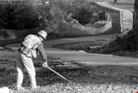
Burnaby Parks Employee
https://search.heritageburnaby.ca/link/archivedescription80770
- Repository
- City of Burnaby Archives
- Date
- December 3, 1997
- Collection/Fonds
- Burnaby NewsLeader photograph collection
- Description Level
- Item
- Physical Description
- 1 photograph : b&w ; 15.5 x 23 cm
- Scope and Content
- Photograph of a Burnaby Parks employee creating a trail pathway around Deer Lake.
- Repository
- City of Burnaby Archives
- Date
- December 3, 1997
- Collection/Fonds
- Burnaby NewsLeader photograph collection
- Physical Description
- 1 photograph : b&w ; 15.5 x 23 cm
- Description Level
- Item
- Record No.
- 535-1027
- Access Restriction
- No restrictions
- Reproduction Restriction
- No reproduction permitted
- Accession Number
- 2012-11
- Scope and Content
- Photograph of a Burnaby Parks employee creating a trail pathway around Deer Lake.
- Subjects
- Geographic Features - Trails
- Media Type
- Photograph
- Photographer
- Bartel, Mario
- Notes
- Title based on contents of photograph
- Note in black ink on recto of photograph reads: "2577 Bby Mario"
- Trim marks and/or reproduction instructions on recto (scan is cropped)
Images


Cut of land on Burnaby Mountain
https://search.heritageburnaby.ca/link/archivedescription97810
- Repository
- City of Burnaby Archives
- Date
- 1996
- Collection/Fonds
- Burnaby Mountain Preservation Society fonds
- Description Level
- Item
- Physical Description
- 1 photograph : col. slide ; 35 mm
- Scope and Content
- Photograph of a cut of land.
- Repository
- City of Burnaby Archives
- Date
- 1996
- Collection/Fonds
- Burnaby Mountain Preservation Society fonds
- Physical Description
- 1 photograph : col. slide ; 35 mm
- Description Level
- Item
- Record No.
- 629-011
- Access Restriction
- No restrictions
- Reproduction Restriction
- Reproduce for fair dealing purposes only
- Accession Number
- 2006-13
- Scope and Content
- Photograph of a cut of land.
- Subjects
- Geographic Features - Trails
- Media Type
- Photograph
- Notes
- Stamp on slide reads: "July 08, 1996."
- Geographic Access
- Burnaby Mountain Conservation Area
- Planning Study Area
- Burnaby Mountain Area
Images
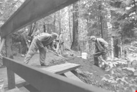
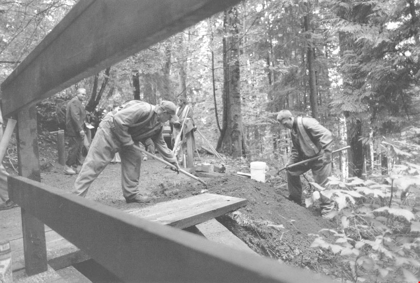
Dave Davidson and Kyle Johnson
https://search.heritageburnaby.ca/link/archivedescription81244
- Repository
- City of Burnaby Archives
- Date
- October 18, 1998
- Collection/Fonds
- Burnaby NewsLeader photograph collection
- Description Level
- Item
- Physical Description
- 1 photograph : b&w ; 15.5 x 22.5 cm
- Scope and Content
- Photograph of Dave Davidson and Kyle Johnson working on a portion of the TransCanada Trail on Burnaby Mountain.
- Repository
- City of Burnaby Archives
- Date
- October 18, 1998
- Collection/Fonds
- Burnaby NewsLeader photograph collection
- Physical Description
- 1 photograph : b&w ; 15.5 x 22.5 cm
- Description Level
- Item
- Record No.
- 535-1388
- Access Restriction
- No restrictions
- Reproduction Restriction
- No reproduction permitted
- Accession Number
- 2012-11
- Scope and Content
- Photograph of Dave Davidson and Kyle Johnson working on a portion of the TransCanada Trail on Burnaby Mountain.
- Subjects
- Geographic Features - Trails
- Names
- Davidson, Dave
- Johnson, Kyle
- Media Type
- Photograph
- Photographer
- Langdeau, Brian
- Notes
- Title based on contents of photograph
- Note in black ink on recto of photograph reads: "9" / 2052 - Bby - Brian"
- Trim marks and/or reproduction instructions on recto (scan is cropped)
- Accompanying caption reads: "Oct 18, 1998 2052: / Dave Davidson and Kyle Johnson work on a portion of the TransCanada Trail on Burnaby Mountain."
Images
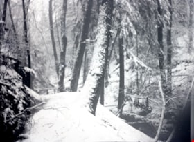
Fourth Street trail
https://search.heritageburnaby.ca/link/archivedescription88403
- Repository
- City of Burnaby Archives
- Date
- February 1946 (date of original), copied 2014
- Collection/Fonds
- James Massey family fonds
- Description Level
- Item
- Physical Description
- 1 photograph (tiff) : sepia ; 600 dpi
- Scope and Content
- Photograph of the Fourth Street trail into Robert Burnaby Park with snow covered ground and trees.
- Repository
- City of Burnaby Archives
- Date
- February 1946 (date of original), copied 2014
- Collection/Fonds
- James Massey family fonds
- Physical Description
- 1 photograph (tiff) : sepia ; 600 dpi
- Description Level
- Item
- Record No.
- 581-009
- Access Restriction
- No restrictions
- Reproduction Restriction
- No known restrictions
- Accession Number
- 2014-34
- Scope and Content
- Photograph of the Fourth Street trail into Robert Burnaby Park with snow covered ground and trees.
- Subjects
- Geographic Features - Trails
- Names
- Massey, Betty
- Media Type
- Photograph
- Notes
- Title based on contents of photograph
- Historic Neighbourhood
- East Burnaby (Historic Neighbourhood)
- Planning Study Area
- Lakeview-Mayfield Area
Images

Frost's Road
https://search.heritageburnaby.ca/link/archivedescription34305
- Repository
- City of Burnaby Archives
- Date
- 1923
- Collection/Fonds
- Burnaby Historical Society fonds
- Description Level
- Item
- Physical Description
- 1 photograph : b&w ; 7.8 x 12.3 cm on page 17.5 x 24 cm
- Scope and Content
- Photograph of a tree-lined path labelled "On Frost's Road." The photograph was taken in Surrey in the Tynehead area.
- Repository
- City of Burnaby Archives
- Date
- 1923
- Collection/Fonds
- Burnaby Historical Society fonds
- Subseries
- Peers family subseries
- Physical Description
- 1 photograph : b&w ; 7.8 x 12.3 cm on page 17.5 x 24 cm
- Description Level
- Item
- Record No.
- 020-012
- Access Restriction
- No restrictions
- Reproduction Restriction
- No known restrictions
- Accession Number
- BHS2007-04
- Scope and Content
- Photograph of a tree-lined path labelled "On Frost's Road." The photograph was taken in Surrey in the Tynehead area.
- Subjects
- Geographic Features - Trails
- Media Type
- Photograph
- Notes
- Title based on caption accompanying photograph
Images


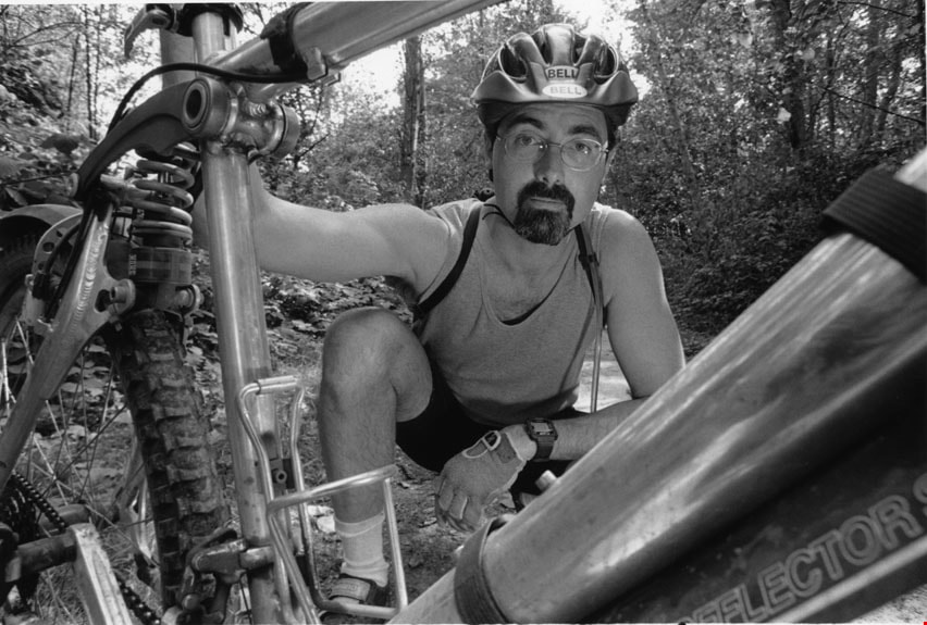
Ron Leavitt
https://search.heritageburnaby.ca/link/archivedescription79468
- Repository
- City of Burnaby Archives
- Date
- August 28, 1996
- Collection/Fonds
- Burnaby NewsLeader photograph collection
- Description Level
- Item
- Physical Description
- 1 photograph : b&w ; 15 x 22 cm
- Scope and Content
- Photograph of Ron Leavitt with his bicycle on a Burnaby Mountain trail.
- Repository
- City of Burnaby Archives
- Date
- August 28, 1996
- Collection/Fonds
- Burnaby NewsLeader photograph collection
- Physical Description
- 1 photograph : b&w ; 15 x 22 cm
- Description Level
- Item
- Record No.
- 535-0399
- Access Restriction
- No restrictions
- Reproduction Restriction
- No reproduction permitted
- Accession Number
- 2012-11
- Scope and Content
- Photograph of Ron Leavitt with his bicycle on a Burnaby Mountain trail.
- Subjects
- Geographic Features - Trails
- Names
- Leavitt, Ron
- Media Type
- Photograph
- Photographer
- Bartel, Mario
- Notes
- Title based on contents of photograph
- Note in black ink on recto of photograph reads: "2148 Bby Mario / Crop / Bby - 1 - 73%"
- Trim marks and/or reproduction instructions on recto (scan is cropped)
- A small piece of dirt is on the lower left side of the photograph
Images
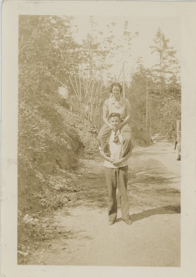
Ruby on shoulders of Crichton Hawkshaw
https://search.heritageburnaby.ca/link/museumdescription19483
- Repository
- Burnaby Village Museum
- Date
- 1936
- Collection/Fonds
- Hawkshaw family fonds
- Description Level
- Item
- Physical Description
- 1 photograph : sepia ; 9 x 6.5 cm
- Scope and Content
- Photograph of Crichton Hawkshaw carrying a woman named Ruby on his shoulders while walking down a trail at Cultus Lake.
- Repository
- Burnaby Village Museum
- Collection/Fonds
- Hawkshaw family fonds
- Description Level
- Item
- Physical Description
- 1 photograph : sepia ; 9 x 6.5 cm
- Scope and Content
- Photograph of Crichton Hawkshaw carrying a woman named Ruby on his shoulders while walking down a trail at Cultus Lake.
- Subjects
- Geographic Features - Trails
- Accession Code
- BV996.6.189
- Access Restriction
- No restrictions
- Reproduction Restriction
- No known restrictions
- Date
- 1936
- Media Type
- Photograph
- Scan Resolution
- 600
- Scan Date
- 2023-02-06
- Notes
- Title based on contents of photograph
- Caption beneath photograph reads: "Ruby & Me / Cultus Lake"
- Photograph is part of photograph album BV996.6.1
Images

![Stoney Creek path, [1998-1999] thumbnail](/media/Hpo/_Data/_Archives_Images/_Unrestricted/316/353-008.jpg?width=280)
Stoney Creek path
https://search.heritageburnaby.ca/link/archivedescription66640
- Repository
- City of Burnaby Archives
- Date
- [1998-1999]
- Collection/Fonds
- Millway family fonds
- Description Level
- Item
- Physical Description
- 1 photograph : col. ; 10 x 30.5 cm
- Scope and Content
- Photograph of the paved walking trail that leads to Stoney Creek Bridge.
- Repository
- City of Burnaby Archives
- Date
- [1998-1999]
- Collection/Fonds
- Millway family fonds
- Physical Description
- 1 photograph : col. ; 10 x 30.5 cm
- Description Level
- Item
- Record No.
- 353-008
- Access Restriction
- No restrictions
- Reproduction Restriction
- Reproduce for fair dealing purposes only
- Accession Number
- 2011-05
- Scope and Content
- Photograph of the paved walking trail that leads to Stoney Creek Bridge.
- Subjects
- Geographic Features - Trails
- Media Type
- Photograph
- Notes
- Title based on contents of photograph
- Historic Neighbourhood
- Burquitlam (Historic Neighbourhood)
- Planning Study Area
- Lyndhurst Area
Images
![Stoney Creek path, [1998-1999] thumbnail](/media/Hpo/_Data/_Archives_Images/_Unrestricted/316/353-008.jpg)
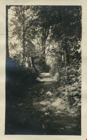
![Two large walnut trees, [194-] (date of original), copied 2014 thumbnail](/media/hpo/_Data/_Archives_Images/_Unrestricted/580/581-010.jpg?width=280)
Two large walnut trees
https://search.heritageburnaby.ca/link/archivedescription88404
- Repository
- City of Burnaby Archives
- Date
- [194-] (date of original), copied 2014
- Collection/Fonds
- James Massey family fonds
- Description Level
- Item
- Physical Description
- 1 photograph (tiff) : sepia ; 600 dpi
- Scope and Content
- Photograph of two large walnut trees on either side of a trail in Robert Burnaby Park.
- Repository
- City of Burnaby Archives
- Date
- [194-] (date of original), copied 2014
- Collection/Fonds
- James Massey family fonds
- Physical Description
- 1 photograph (tiff) : sepia ; 600 dpi
- Description Level
- Item
- Record No.
- 581-010
- Access Restriction
- No restrictions
- Reproduction Restriction
- No reproduction permitted
- Accession Number
- 2014-34
- Scope and Content
- Photograph of two large walnut trees on either side of a trail in Robert Burnaby Park.
- Media Type
- Photograph
- Notes
- Title based on contents of photograph
- Historic Neighbourhood
- East Burnaby (Historic Neighbourhood)
- Planning Study Area
- Lakeview-Mayfield Area
Images
![Two large walnut trees, [194-] (date of original), copied 2014 thumbnail](/media/hpo/_Data/_Archives_Images/_Unrestricted/580/581-010.jpg)
![Burnaby creek conservationists, [2002] thumbnail](/media/hpo/_Data/_Archives_Images/_Unrestricted/535/535-1959-1.jpg?width=280)
Burnaby creek conservationists
https://search.heritageburnaby.ca/link/archivedescription96276
- Repository
- City of Burnaby Archives
- Date
- [2002]
- Collection/Fonds
- Burnaby NewsLeader photograph collection
- Description Level
- File
- Physical Description
- 4 photographs (tiff) : col.
- Scope and Content
- File contains photographs of volunteer conservationists with the Eagle Creek Streamkeepers, Byrne Creek Streamkeepers, and Sapperton Fish & Game Club at work in the Lake City area by Eagle Creek and the Brunette River. Photographs depict Nick Kvenich, of the Eagle Creek Streamkeepers, in a creek; m…
- Repository
- City of Burnaby Archives
- Date
- [2002]
- Collection/Fonds
- Burnaby NewsLeader photograph collection
- Physical Description
- 4 photographs (tiff) : col.
- Description Level
- File
- Record No.
- 535-1959
- Access Restriction
- No restrictions
- Reproduction Restriction
- No restrictions
- Accession Number
- 2018-12
- Scope and Content
- File contains photographs of volunteer conservationists with the Eagle Creek Streamkeepers, Byrne Creek Streamkeepers, and Sapperton Fish & Game Club at work in the Lake City area by Eagle Creek and the Brunette River. Photographs depict Nick Kvenich, of the Eagle Creek Streamkeepers, in a creek; members of the Byrne Creek Streamkeepers observing a storm drain; and Elmer Rudolf feeding fish at a Sapperton Fish & Game Club hatchery.
- Subjects
- Geographic Features - Creeks
- Geographic Features - Lakes and Ponds
- Geographic Features - Ravines
- Geographic Features - Streams
- Media Type
- Photograph
- Photographer
- Bartel, Mario
- Notes
- Title based on caption
- Collected by editorial for use in a March 2002 issue of the Burnaby NewsLeader
- Caption from metadata for 535-1959-1: "Nick Kvenich is one of the founding members of the Eagle Creek Streamkeepers, which is looking to preserve the habitat of the creek that runs down from Squint Lake into a ravine below the Lake City industrial area."
- Caption from metadata for 535-1959-2: "Joan Carne (r) and Louise Towell, of the Byrne Creek Streamkeepers, examine a storm drain in an industrial area above the creek. The habitat faces constant pressure from businesses and homeowners who pour solvents, soaps and substances into the drains without thought to the consequences."
- Caption from metadata for 535-1959-3: "Nick Kvenich, one of the founding members of the Eagle Creek Streamkeepers, climbs through a fallen tree that is blocking a trail that runs alongside the creek, in a ravine below the Lake City industrial area. Although the tree will eventually be cleared by the GVRD, Kvenich says he prefers if such obstacles be left alone, as they would discourage people who might abuse the habitat."
- Caption from metadata for 535-1959-4: "Elmer Rudolf feeds a new batch of coho fry at the Sapperton Fish & Game Club's hatchery, near the Brunette River. The fry are normally fed by a timed conveyor belt, but that is supplemented by hand feedings to give the weaker fish a chance."
- Geographic Access
- Brunette River
- Eagle Creek
- Planning Study Area
- Lake City Area
Images
![Burnaby creek conservationists, [2002] thumbnail](/media/hpo/_Data/_Archives_Images/_Unrestricted/535/535-1959-1.jpg)
![View of lake, [191-] thumbnail](/media/hpo/_Data/_BVM_Images/2022/2022_0032_0093_001.jpg?width=280)
View of lake
https://search.heritageburnaby.ca/link/museumdescription19671
- Repository
- Burnaby Village Museum
- Date
- [191-]
- Collection/Fonds
- Esther Love Stanley fonds
- Description Level
- Item
- Physical Description
- 1 photograph : b&w ; 8.5 x 11 cm
- Scope and Content
- Photograph of view of lake with forest and shoreline (could be Stave Lake or Pitt Lake).
- Repository
- Burnaby Village Museum
- Collection/Fonds
- Esther Love Stanley fonds
- Description Level
- Item
- Physical Description
- 1 photograph : b&w ; 8.5 x 11 cm
- Scope and Content
- Photograph of view of lake with forest and shoreline (could be Stave Lake or Pitt Lake).
- Subjects
- Geographic Features - Natural Waterways
- Geographic Features
- Geographic Features - Natural Geographic Features
- Accession Code
- BV022.32.93
- Access Restriction
- No restrictions
- Reproduction Restriction
- No known restrictions
- Date
- [191-]
- Media Type
- Photograph
- Scan Resolution
- 600
- Scan Date
- 2023-04-04
- Notes
- Title based on contents of photograph
- Photograph is part of Esther Love Stanley photograph album 1 (BV022.32.1)
Images
![View of lake, [191-] thumbnail](/media/hpo/_Data/_BVM_Images/2022/2022_0032_0093_001.jpg)

Across the inlet from Barnet
https://search.heritageburnaby.ca/link/museumdescription15222
- Repository
- Burnaby Village Museum
- Date
- July 1934 (date of original), copied 2004
- Collection/Fonds
- In the Shadow by the Sea collection
- Description Level
- Item
- Physical Description
- 1 photograph (tiff) : 300 dpi
- Scope and Content
- Photograph looking across Burrard Inlet from the Village of Barnet. The rugged coastline of the north shore of the inlet is visible with rock formations and forest.
- Repository
- Burnaby Village Museum
- Collection/Fonds
- In the Shadow by the Sea collection
- Description Level
- Item
- Physical Description
- 1 photograph (tiff) : 300 dpi
- Material Details
- Original photograph appears to be hand coloured
- Scope and Content
- Photograph looking across Burrard Inlet from the Village of Barnet. The rugged coastline of the north shore of the inlet is visible with rock formations and forest.
- Subjects
- Geographic Features - Inlets
- Geographic Features - Rock Formations
- Geographic Features - Forests
- Geographic Access
- Burrard Inlet
- Accession Code
- BV019.32.42
- Access Restriction
- No restrictions
- Reproduction Restriction
- No known restrictions
- Date
- July 1934 (date of original), copied 2004
- Media Type
- Photograph
- Historic Neighbourhood
- Barnet (Historic Neighbourhood)
- Planning Study Area
- Burnaby Mountain Area
- Notes
- Title based on contents of photograph
Images
