More like 'Conway Castle'
Narrow Results By
Decade
- 2020s 97
- 2010s 44
- 2000s 490
- 1990s 408
- 1980s 411
- 1970s 949
- 1960s 285
- 1950s 470
- 1940s 442
- 1930s 401
- 1920s 451
- 1910s 528
- 1900s 192
- 1890s 24
- 1880s 51
- 1870s 3
- 1860s 1
- 1850s 1
- 1840s 1
- 1830s 1
- 1820s 1
- 1810s 1
- 1800s 1
- 1790s 1
- 1780s 1
- 1770s 1
- 1760s 1
- 1750s 1
- 1740s 1
- 1730s 1
- 1720s 1
- 1710s 1
- 1700s 1
- 1690s 1
- 1680s 1
- 1670s 1
- 1660s 1
- 1650s 1
- 1640s 1
- 1630s 1
- 1620s 1
- 1610s 1
- 1600s 1
Subject
- Accidents 3
- Accidents - Automobile Accidents 1
- Adornment 1
- Advertising Medium 4
- Advertising Medium - Signs and Signboards 97
- Aerial Photographs 28
- Agricultural Tools and Equipment - Plows 3
- Agriculture 4
- Agriculture - Crops 2
- Agriculture - Dairy 1
- Agriculture - Farms 57
- Agriculture - Fruit and Berries 8
![Burrard Inlet, [1930] thumbnail](/media/hpo/_Data/_Archives_Images/_Unrestricted/371/443-013.jpg?width=280)
Burrard Inlet
https://search.heritageburnaby.ca/link/archivedescription38446
- Repository
- City of Burnaby Archives
- Date
- [1930]
- Collection/Fonds
- Burnaby Historical Society fonds
- Description Level
- Item
- Physical Description
- 1 photograph : b&w ; 6.4 x 9 cm
- Scope and Content
- Photograph looking west from 410 North Hythe Avenue towards Burrard Inlet. The Second Narrows Bridge can be seen faintly in the background.
- Repository
- City of Burnaby Archives
- Date
- [1930]
- Collection/Fonds
- Burnaby Historical Society fonds
- Subseries
- Photographs subseries
- Physical Description
- 1 photograph : b&w ; 6.4 x 9 cm
- Description Level
- Item
- Record No.
- 443-013
- Access Restriction
- No restrictions
- Reproduction Restriction
- No known restrictions
- Accession Number
- BHS2002-13
- Scope and Content
- Photograph looking west from 410 North Hythe Avenue towards Burrard Inlet. The Second Narrows Bridge can be seen faintly in the background.
- Media Type
- Photograph
- Notes
- Title based on contents of photograph
- Geographic Access
- Hythe Avenue North
- Street Address
- 410 Hythe Avenue North
- Historic Neighbourhood
- Capitol Hill (Historic Neighbourhood)
- Planning Study Area
- Capitol Hill Area
Images
![Burrard Inlet, [1930] thumbnail](/media/hpo/_Data/_Archives_Images/_Unrestricted/371/443-013.jpg)
![Burrard Inlet, [1930] thumbnail](/media/hpo/_Data/_Archives_Images/_Unrestricted/371/443-014.jpg?width=280)
Burrard Inlet
https://search.heritageburnaby.ca/link/archivedescription38447
- Repository
- City of Burnaby Archives
- Date
- [1930]
- Collection/Fonds
- Burnaby Historical Society fonds
- Description Level
- Item
- Physical Description
- 1 photograph : b&w ; 6.3 x 9 cm
- Scope and Content
- Photograph taken from 410 North Hythe Avenue looking towards the Burrard Inlet. The Second Narrows Bridge can be seen faintly in the background.
- Repository
- City of Burnaby Archives
- Date
- [1930]
- Collection/Fonds
- Burnaby Historical Society fonds
- Subseries
- Photographs subseries
- Physical Description
- 1 photograph : b&w ; 6.3 x 9 cm
- Description Level
- Item
- Record No.
- 443-014
- Access Restriction
- No restrictions
- Reproduction Restriction
- No known restrictions
- Accession Number
- BHS2002-13
- Scope and Content
- Photograph taken from 410 North Hythe Avenue looking towards the Burrard Inlet. The Second Narrows Bridge can be seen faintly in the background.
- Media Type
- Photograph
- Notes
- Title based on contents of photograph.
- Geographic Access
- Hythe Avenue North
- Street Address
- 410 Hythe Avenue North
- Historic Neighbourhood
- Capitol Hill (Historic Neighbourhood)
- Planning Study Area
- Capitol Hill Area
Images
![Burrard Inlet, [1930] thumbnail](/media/hpo/_Data/_Archives_Images/_Unrestricted/371/443-014.jpg)
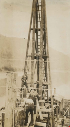
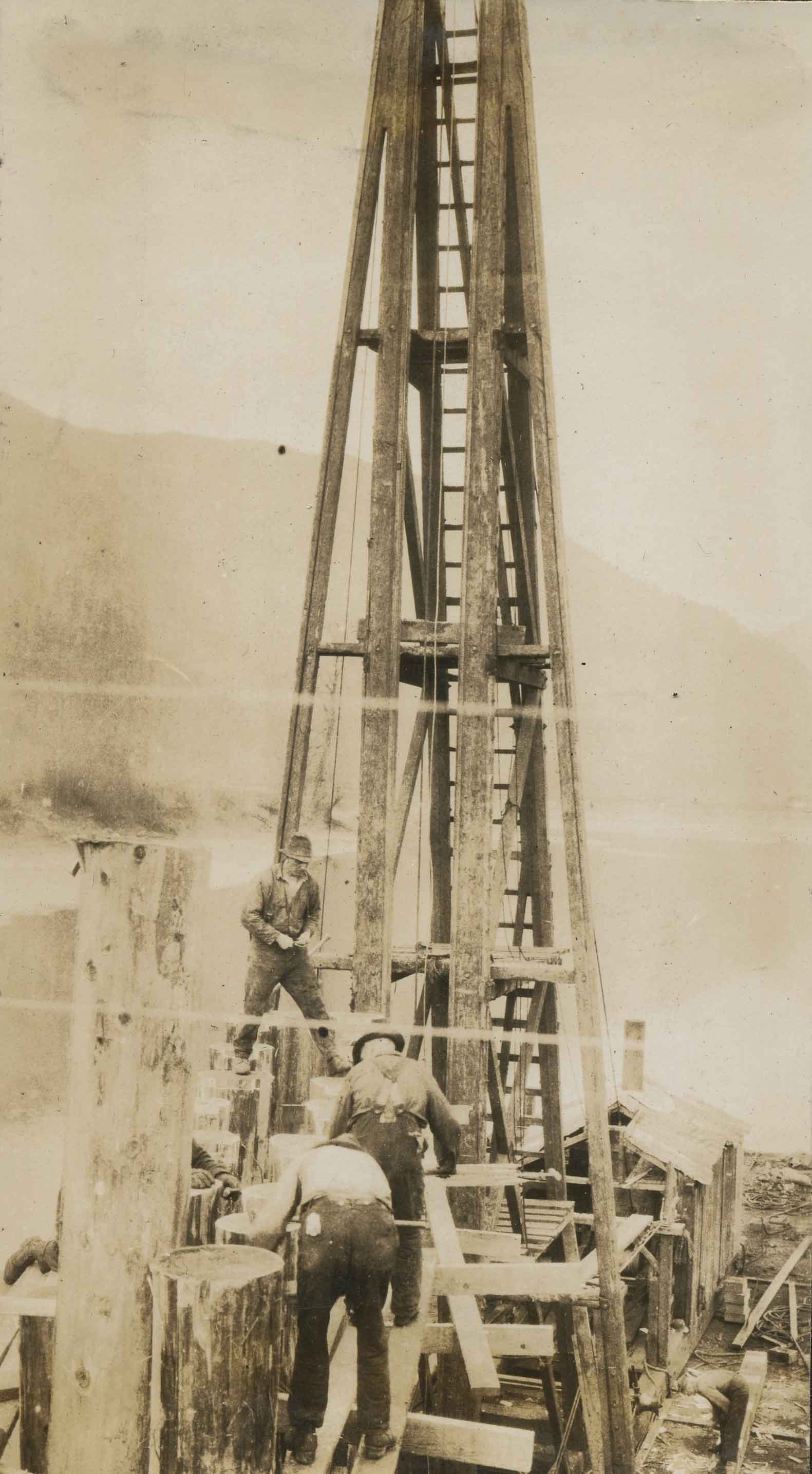
![Campbell River truss, [1919] thumbnail](/media/hpo/_Data/_BVM_Images/1974/197500330003bd.jpg?width=280)
Campbell River truss
https://search.heritageburnaby.ca/link/museumdescription3535
- Repository
- Burnaby Village Museum
- Date
- [1919]
- Collection/Fonds
- Burnaby Village Museum Photograph collection
- Description Level
- Item
- Physical Description
- 1 photograph : b&w ; 8 x 13 cm
- Scope and Content
- Photograph of three people standing on a truss in Campbell River. Taken from the west, up river side of the trestle. Tom Irvine was one of the pile drivers who helped to build this bridge.
- Repository
- Burnaby Village Museum
- Collection/Fonds
- Burnaby Village Museum Photograph collection
- Description Level
- Item
- Physical Description
- 1 photograph : b&w ; 8 x 13 cm
- Scope and Content
- Photograph of three people standing on a truss in Campbell River. Taken from the west, up river side of the trestle. Tom Irvine was one of the pile drivers who helped to build this bridge.
- History
- Bloedel Stewart and Welch built a trestle over the Campbell River in Spring 1925. BS&W acquired a timber lease on the south side of the Campbell River in order to access operations at Sayward. This is now the site of the John Hart Hydro Dam.
- Subjects
- Structures - Bridges
- Accession Code
- HV975.33.3bd
- Access Restriction
- No restrictions
- Date
- [1919]
- Media Type
- Photograph
- Scan Resolution
- 600
- Scan Date
- 2/2/2010
- Scale
- 100
- Notes
- Title based on contents of photograph
- Note in black ink on verso of photograph reads: "Campbell River spand [sic]"
- Image from personal photograph album of Tom "Tommy" Irvine (HV975.33.3)
Images
![Campbell River truss, [1919] thumbnail](/media/hpo/_Data/_BVM_Images/1974/197500330003bd.jpg)
![Canadian National Railway Bridge, [between 1930 and 1934] (date of original), copied 1991 thumbnail](/media/hpo/_Data/_Archives_Images/_Unrestricted/370/370-059.jpg?width=280)
Canadian National Railway Bridge
https://search.heritageburnaby.ca/link/archivedescription37471
- Repository
- City of Burnaby Archives
- Date
- [between 1930 and 1934] (date of original), copied 1991
- Collection/Fonds
- Burnaby Historical Society fonds
- Description Level
- Item
- Physical Description
- 1 photograph : b&w ; 2.7 x 4.1 cm print on contact sheet 20.2 x 25.3 cm
- Scope and Content
- Photograph of the Canadian National Railway (CNR) Bridge over the Fraser River open to allow ships through. No boats are visible.
- Repository
- City of Burnaby Archives
- Date
- [between 1930 and 1934] (date of original), copied 1991
- Collection/Fonds
- Burnaby Historical Society fonds
- Subseries
- Burnaby Image Bank subseries
- Physical Description
- 1 photograph : b&w ; 2.7 x 4.1 cm print on contact sheet 20.2 x 25.3 cm
- Description Level
- Item
- Record No.
- 370-059
- Access Restriction
- No restrictions
- Reproduction Restriction
- No known restrictions
- Accession Number
- BHS1999-03
- Scope and Content
- Photograph of the Canadian National Railway (CNR) Bridge over the Fraser River open to allow ships through. No boats are visible.
- Media Type
- Photograph
- Photographer
- Bellinger, Bernard
- Notes
- Title based on contents of photograph
- 1 b&w copy negative accompanying
- Historic Neighbourhood
- Fraser Arm (Historic Neighbourhood)
- Planning Study Area
- Big Bend Area
Images
![Canadian National Railway Bridge, [between 1930 and 1934] (date of original), copied 1991 thumbnail](/media/hpo/_Data/_Archives_Images/_Unrestricted/370/370-059.jpg)
![Capilano suspension bridge, [1938 or 1939] thumbnail](/media/hpo/_Data/_BVM_Images/2017/201700280037_001.jpg?width=280)
Capilano suspension bridge
https://search.heritageburnaby.ca/link/museumdescription4240
- Repository
- Burnaby Village Museum
- Date
- [1938 or 1939]
- Collection/Fonds
- Burnaby Village Museum Photograph collection
- Description Level
- Item
- Physical Description
- 1 photograph : b&w ; 7.5 x 12 cm
- Scope and Content
- Photograph of the Capilano Suspension Bridge taken from below and looking north.
- Repository
- Burnaby Village Museum
- Collection/Fonds
- Burnaby Village Museum Photograph collection
- Description Level
- Item
- Physical Description
- 1 photograph : b&w ; 7.5 x 12 cm
- Material Details
- Handwritten text reading: Capilano Suspension Bridge" on back. "28" stamped on back.
- Scope and Content
- Photograph of the Capilano Suspension Bridge taken from below and looking north.
- Subjects
- Structures - Bridges
- Accession Code
- BV017.28.37
- Access Restriction
- No restrictions
- Reproduction Restriction
- No known restrictions
- Date
- [1938 or 1939]
- Media Type
- Photograph
- Scan Resolution
- 600
- Scan Date
- 06-Mar-2018
- Notes
- Title based on contents of photograph
Images
![Capilano suspension bridge, [1938 or 1939] thumbnail](/media/hpo/_Data/_BVM_Images/2017/201700280037_001.jpg)
![Carquinez bridge over Carquinez Strait, [1936] (date of original), copied 1996 thumbnail](/media/hpo/_Data/_BVM_Images/2022/2022_0002_0035_001.jpg?width=280)
Carquinez bridge over Carquinez Strait
https://search.heritageburnaby.ca/link/museumdescription18105
- Repository
- Burnaby Village Museum
- Date
- [1936] (date of original), copied 1996
- Collection/Fonds
- Burnaby Village Museum fonds
- Description Level
- Item
- Physical Description
- 1 photograph : b&w negative ; 35 mm
- Scope and Content
- Photograph of the Carquinez bridge over the Carquinez Strait at the northeastern end of San Francisco Bay. Photograph was taken while Dora and Jimmy Robertson traveled to the United States to assist in bringing the C.W. Parker no. 119 carousel to Happyland in Vancouver after it was purchased.
- Repository
- Burnaby Village Museum
- Collection/Fonds
- Burnaby Village Museum fonds
- Subseries
- Carousel photographs subseries
- Description Level
- Item
- Physical Description
- 1 photograph : b&w negative ; 35 mm
- Scope and Content
- Photograph of the Carquinez bridge over the Carquinez Strait at the northeastern end of San Francisco Bay. Photograph was taken while Dora and Jimmy Robertson traveled to the United States to assist in bringing the C.W. Parker no. 119 carousel to Happyland in Vancouver after it was purchased.
- Subjects
- Structures - Bridges
- Accession Code
- BV022.2.35
- Access Restriction
- No restrictions
- Reproduction Restriction
- No known restrictions
- Date
- [1936] (date of original), copied 1996
- Media Type
- Photograph
- Scan Resolution
- 2400
- Scan Date
- 2021-08-17
- Notes
- Title based on contents of photograph
- Photograph from Roll P96-3, negative #8
- Photograph copied from Robertson family album
Images
![Carquinez bridge over Carquinez Strait, [1936] (date of original), copied 1996 thumbnail](/media/hpo/_Data/_BVM_Images/2022/2022_0002_0035_001.jpg)

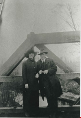
Claude and Kitty on a footbridge
https://search.heritageburnaby.ca/link/archivedescription39558
- Repository
- City of Burnaby Archives
- Date
- 1910
- Collection/Fonds
- Peers Family and Hill Family fonds
- Description Level
- Item
- Physical Description
- 1 photograph : b&w ; 7.5 x 10 cm on page 21.5 x 28 cm (pasted in album)
- Scope and Content
- Photograph of Claude Hill with his daughter Kitty standing on a foot bridge over a small creek. In the background directly behind Kitty can be seen the Hill family home known as Broadview which was located on Buckingham Avenue. The Pole Line Road (later renamed Sperling Avenue) can also be seen. …
- Repository
- City of Burnaby Archives
- Date
- 1910
- Collection/Fonds
- Peers Family and Hill Family fonds
- Physical Description
- 1 photograph : b&w ; 7.5 x 10 cm on page 21.5 x 28 cm (pasted in album)
- Description Level
- Item
- Record No.
- 477-877
- Access Restriction
- No restrictions
- Reproduction Restriction
- No known restrictions
- Accession Number
- 2007-12
- Scope and Content
- Photograph of Claude Hill with his daughter Kitty standing on a foot bridge over a small creek. In the background directly behind Kitty can be seen the Hill family home known as Broadview which was located on Buckingham Avenue. The Pole Line Road (later renamed Sperling Avenue) can also be seen. At the far left, top corner of the photograph another house is visible. This was the home of Francis J. Peers, on what is now Rugby Avenue (5289 Rugby). This house was known as Greyfriars. Kitty Hill would later marry Bob Peers, son of Francis.
- Subjects
- Structures - Bridges
- Media Type
- Photograph
- Notes
- Title based on contents of photograph
- Geographic Access
- Buckingham Avenue
- Sperling Avenue
- Street Address
- 5730 Buckingham Avenue
- Historic Neighbourhood
- Burnaby Lake (Historic Neighbourhood)
- Planning Study Area
- Morley-Buckingham Area
Images


Collapse of Second Narrows Bridge
https://search.heritageburnaby.ca/link/archivedescription37290
- Repository
- City of Burnaby Archives
- Date
- 1958
- Collection/Fonds
- Burnaby Historical Society fonds
- Description Level
- Item
- Physical Description
- 1 photograph : b&w ; 9.5 x 9.5 cm
- Scope and Content
- Photograph shows a picture of the Second Narrows Bridge in Vancouver, BC after its collapse in 1958.
- Repository
- City of Burnaby Archives
- Date
- 1958
- Collection/Fonds
- Burnaby Historical Society fonds
- Subseries
- Norah Code subseries
- Physical Description
- 1 photograph : b&w ; 9.5 x 9.5 cm
- Description Level
- Item
- Record No.
- 345-011
- Access Restriction
- No restrictions
- Reproduction Restriction
- Reproduce for fair dealing purposes only
- Accession Number
- BHS1997-05
- Scope and Content
- Photograph shows a picture of the Second Narrows Bridge in Vancouver, BC after its collapse in 1958.
- Subjects
- Structures - Bridges
- Media Type
- Photograph
- Notes
- Title based on contents of photograph.
- Photographs in this collection were taken and compiled by Norah Code, former editor of the "Burnaby Courier" newspaper during the course of her work for the newspaper.
Images

Cutting pile tops for Nicomen Slough Bridge
https://search.heritageburnaby.ca/link/archivedescription34328
- Repository
- City of Burnaby Archives
- Date
- 1927
- Collection/Fonds
- Burnaby Historical Society fonds
- Description Level
- Item
- Physical Description
- 1 photograph : b&w ; 6.8 x 12.2 cm on page 17.5 x 23.7 cm
- Scope and Content
- Photograph of workmen operating machinery to cut pile tops for the Nicomen Slough Bridge, near Deroche.
- Repository
- City of Burnaby Archives
- Date
- 1927
- Collection/Fonds
- Burnaby Historical Society fonds
- Subseries
- Peers family subseries
- Physical Description
- 1 photograph : b&w ; 6.8 x 12.2 cm on page 17.5 x 23.7 cm
- Description Level
- Item
- Record No.
- 020-035
- Access Restriction
- No restrictions
- Reproduction Restriction
- No known restrictions
- Accession Number
- BHS2007-04
- Scope and Content
- Photograph of workmen operating machinery to cut pile tops for the Nicomen Slough Bridge, near Deroche.
- Subjects
- Construction - Bridge Construction
- Structures - Bridges
- Construction Tools and Equipment
- Occupations - Labourers
- Media Type
- Photograph
- Notes
- Title based on caption accompanying photograph
Images
![Detail of First Narrows Bridge, [1938] thumbnail](/media/hpo/_Data/_BVM_Images/1996/1996_0006_0232_001.jpg?width=280)
Detail of First Narrows Bridge
https://search.heritageburnaby.ca/link/museumdescription19525
- Repository
- Burnaby Village Museum
- Date
- [1938]
- Collection/Fonds
- Hawkshaw family fonds
- Description Level
- Item
- Physical Description
- 1 photograph : sepia ; 6.5 x 9 cm
- Scope and Content
- Photograph detail of steel structure of the First Narrows Bridge (Lions Gate Bridge) that crosses the first narrows of Burrard Inlet connecting Vancouver to the North Shore.
- Repository
- Burnaby Village Museum
- Collection/Fonds
- Hawkshaw family fonds
- Description Level
- Item
- Physical Description
- 1 photograph : sepia ; 6.5 x 9 cm
- Scope and Content
- Photograph detail of steel structure of the First Narrows Bridge (Lions Gate Bridge) that crosses the first narrows of Burrard Inlet connecting Vancouver to the North Shore.
- Subjects
- Structures - Bridges
- Accession Code
- BV996.6.232
- Access Restriction
- No restrictions
- Reproduction Restriction
- No known restrictions
- Date
- [1938]
- Media Type
- Photograph
- Scan Resolution
- 600
- Scan Date
- 2023-02-16
- Notes
- Title based on contents of photograph
- Caption on photograph album page reads: "1st Narrows Bridge"
- Photograph is part of photograph album BV996.6.1
Images
![Detail of First Narrows Bridge, [1938] thumbnail](/media/hpo/_Data/_BVM_Images/1996/1996_0006_0232_001.jpg)
![Detail of First Narrows Bridge, [1938] thumbnail](/media/hpo/_Data/_BVM_Images/1996/1996_0006_0235_001.jpg?width=280)
Detail of First Narrows Bridge
https://search.heritageburnaby.ca/link/museumdescription19528
- Repository
- Burnaby Village Museum
- Date
- [1938]
- Collection/Fonds
- Hawkshaw family fonds
- Description Level
- Item
- Physical Description
- 1 photograph : sepia ; 6.5 x 9 cm
- Scope and Content
- Photograph detail of steel structure of the First Narrows Bridge (Lions Gate Bridge) that crosses the first narrows of Burrard Inlet connecting Vancouver to the North Shore.
- Repository
- Burnaby Village Museum
- Collection/Fonds
- Hawkshaw family fonds
- Description Level
- Item
- Physical Description
- 1 photograph : sepia ; 6.5 x 9 cm
- Scope and Content
- Photograph detail of steel structure of the First Narrows Bridge (Lions Gate Bridge) that crosses the first narrows of Burrard Inlet connecting Vancouver to the North Shore.
- Subjects
- Structures - Bridges
- Accession Code
- BV996.6.235
- Access Restriction
- No restrictions
- Reproduction Restriction
- No known restrictions
- Date
- [1938]
- Media Type
- Photograph
- Scan Resolution
- 600
- Scan Date
- 2023-02-16
- Notes
- Title based on contents of photograph
- Photograph is part of photograph album BV996.6.1
Images
![Detail of First Narrows Bridge, [1938] thumbnail](/media/hpo/_Data/_BVM_Images/1996/1996_0006_0235_001.jpg)

Driving over a log bridge
https://search.heritageburnaby.ca/link/archivedescription36026
- Repository
- City of Burnaby Archives
- Date
- 1912
- Collection/Fonds
- Burnaby Historical Society fonds
- Description Level
- Item
- Physical Description
- 1 photograph : sepia ; 7.7 x 10.3 cm
- Scope and Content
- Photograph of Patterson's car driving over a log bridge, believed to be the Cariboo Road Bridge over the Brunette river. A man in a trilby hat is in the driver's side of the car, with his hand on the steering wheel, facing the camera.
- Repository
- City of Burnaby Archives
- Date
- 1912
- Collection/Fonds
- Burnaby Historical Society fonds
- Subseries
- Patterson family subseries
- Physical Description
- 1 photograph : sepia ; 7.7 x 10.3 cm
- Description Level
- Item
- Record No.
- 213-008
- Access Restriction
- No restrictions
- Reproduction Restriction
- No known restrictions
- Accession Number
- BHS1988-13
- Scope and Content
- Photograph of Patterson's car driving over a log bridge, believed to be the Cariboo Road Bridge over the Brunette river. A man in a trilby hat is in the driver's side of the car, with his hand on the steering wheel, facing the camera.
- Media Type
- Photograph
- Notes
- Title based on contents of photograph
- Geographic Access
- Cariboo Road
- Planning Study Area
- Burnaby Lake Area
Images

![E.B. Wetenhall and Kitty Hill, [1902] thumbnail](/media/hpo/_Data/_Archives_Images/_Unrestricted/477/477-100.jpg?width=280)
E.B. Wetenhall and Kitty Hill
https://search.heritageburnaby.ca/link/archivedescription38781
- Repository
- City of Burnaby Archives
- Date
- [1902]
- Collection/Fonds
- Peers Family and Hill Family fonds
- Description Level
- Item
- Physical Description
- 1 photograph : b&w ; 6 x 8 cm on page 11.5 x 14 cm (pasted in album)
- Scope and Content
- Photograph of E.B. Wetenhall leading a horse to water. Kitty Hill is the foreground and a wooden trestle bridge spans Deer Lake Brook in the background.
- Repository
- City of Burnaby Archives
- Date
- [1902]
- Collection/Fonds
- Peers Family and Hill Family fonds
- Physical Description
- 1 photograph : b&w ; 6 x 8 cm on page 11.5 x 14 cm (pasted in album)
- Description Level
- Item
- Record No.
- 477-100
- Access Restriction
- No restrictions
- Reproduction Restriction
- No known restrictions
- Accession Number
- 2007-12
- Scope and Content
- Photograph of E.B. Wetenhall leading a horse to water. Kitty Hill is the foreground and a wooden trestle bridge spans Deer Lake Brook in the background.
- Media Type
- Photograph
- Notes
- Title based on contents of photograph
- Geographic Access
- Deer Lake Brook
- Deer Lake Avenue
- Street Address
- 6501 Deer Lake Avenue
- Historic Neighbourhood
- Burnaby Lake (Historic Neighbourhood)
- Planning Study Area
- Morley-Buckingham Area
Images
![E.B. Wetenhall and Kitty Hill, [1902] thumbnail](/media/hpo/_Data/_Archives_Images/_Unrestricted/477/477-100.jpg)

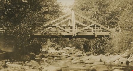
Emory Creek Bridge
https://search.heritageburnaby.ca/link/archivedescription34490
- Repository
- City of Burnaby Archives
- Date
- 1925
- Collection/Fonds
- Burnaby Historical Society fonds
- Description Level
- Item
- Physical Description
- 1 photograph : b&w ; 7.2 x 13.3 cm on page 17.5 x 26.4 cm
- Scope and Content
- Photograph of a wooden bridge spanning Emory Creek. Three people can be seen standing on the bridge and they are identified as R.H.B., E.D., and A.S.D. This photograph appears to have been taken by Arthur Peers, who travelled through the Fraser River Valley and worked on the construction of the T…
- Repository
- City of Burnaby Archives
- Date
- 1925
- Collection/Fonds
- Burnaby Historical Society fonds
- Subseries
- Peers family subseries
- Physical Description
- 1 photograph : b&w ; 7.2 x 13.3 cm on page 17.5 x 26.4 cm
- Description Level
- Item
- Record No.
- 020-197
- Access Restriction
- No restrictions
- Reproduction Restriction
- No restrictions
- Accession Number
- BHS2007-04
- Scope and Content
- Photograph of a wooden bridge spanning Emory Creek. Three people can be seen standing on the bridge and they are identified as R.H.B., E.D., and A.S.D. This photograph appears to have been taken by Arthur Peers, who travelled through the Fraser River Valley and worked on the construction of the Trans-Provincial Highway during the later 1920s.
- Media Type
- Photograph
- Photographer
- Peers, Arthur Francis "Mike"
- Notes
- Title based on caption accompanying photograph
Images
Esther Love and Frank Stanley
https://search.heritageburnaby.ca/link/archivedescription35730
- Repository
- City of Burnaby Archives
- Date
- 1918 (date of original), copied 1986
- Collection/Fonds
- Burnaby Historical Society fonds
- Description Level
- Item
- Physical Description
- 1 photograph : b&w ; 12.7 x 17.8 cm print
- Scope and Content
- Photograph of (left to right) Esther Love and Frank Stanley (her fiance). This photograph was probably taken on the Cariboo Road bridge over the Brunette River during their courtship.
- Repository
- City of Burnaby Archives
- Date
- 1918 (date of original), copied 1986
- Collection/Fonds
- Burnaby Historical Society fonds
- Subseries
- Pioneer Tales subseries
- Physical Description
- 1 photograph : b&w ; 12.7 x 17.8 cm print
- Description Level
- Item
- Record No.
- 204-588
- Access Restriction
- No restrictions
- Reproduction Restriction
- No known restrictions
- Accession Number
- BHS1988-03
- Scope and Content
- Photograph of (left to right) Esther Love and Frank Stanley (her fiance). This photograph was probably taken on the Cariboo Road bridge over the Brunette River during their courtship.
- Subjects
- Structures - Bridges
- Media Type
- Photograph
- Notes
- Title based on contents of photograph
- Geographic Access
- Cariboo Road
- Planning Study Area
- Burnaby Lake Area
Images

![Exit the Old Bridge, [1927] thumbnail](/media/hpo/_Data/_Archives_Images/_Unrestricted/001/020-143.jpg?width=280)
Exit the Old Bridge
https://search.heritageburnaby.ca/link/archivedescription34436
- Repository
- City of Burnaby Archives
- Date
- [1927]
- Collection/Fonds
- Burnaby Historical Society fonds
- Description Level
- Item
- Physical Description
- 1 photograph : b&w ; 7 x 10.4 cm on page 17.5 x 26 cm
- Scope and Content
- Photograph of the old bridge structure at Nicomen Slough. A caption accompanying the picture reads: "Exit the old bridge." The roof of an unidentified building can be seen in the background.
- Repository
- City of Burnaby Archives
- Date
- [1927]
- Collection/Fonds
- Burnaby Historical Society fonds
- Subseries
- Peers family subseries
- Physical Description
- 1 photograph : b&w ; 7 x 10.4 cm on page 17.5 x 26 cm
- Description Level
- Item
- Record No.
- 020-143
- Access Restriction
- No restrictions
- Reproduction Restriction
- No known restrictions
- Accession Number
- BHS2007-04
- Scope and Content
- Photograph of the old bridge structure at Nicomen Slough. A caption accompanying the picture reads: "Exit the old bridge." The roof of an unidentified building can be seen in the background.
- Media Type
- Photograph
- Notes
- Title based on caption accompanying photograph
Images
![Exit the Old Bridge, [1927] thumbnail](/media/hpo/_Data/_Archives_Images/_Unrestricted/001/020-143.jpg)
![First Narrows Bridge, [1938] thumbnail](/media/hpo/_Data/_BVM_Images/1996/1996_0006_0233_001.jpg?width=280)
First Narrows Bridge
https://search.heritageburnaby.ca/link/museumdescription19526
- Repository
- Burnaby Village Museum
- Date
- [1938]
- Collection/Fonds
- Hawkshaw family fonds
- Description Level
- Item
- Physical Description
- 1 photograph : sepia ; 6.5 x 9 cm
- Scope and Content
- Photograph of the First Narrows Bridge (Lions Gate Bridge). Photograph is taken from the shore looking west towards the suspension bridge which spans the first narrows of Burrard Inet connecting the City of Vancouver to the North Shore.
- Repository
- Burnaby Village Museum
- Collection/Fonds
- Hawkshaw family fonds
- Description Level
- Item
- Physical Description
- 1 photograph : sepia ; 6.5 x 9 cm
- Scope and Content
- Photograph of the First Narrows Bridge (Lions Gate Bridge). Photograph is taken from the shore looking west towards the suspension bridge which spans the first narrows of Burrard Inet connecting the City of Vancouver to the North Shore.
- Accession Code
- BV996.6.233
- Access Restriction
- No restrictions
- Reproduction Restriction
- No known restrictions
- Date
- [1938]
- Media Type
- Photograph
- Scan Resolution
- 600
- Scan Date
- 2023-02-16
- Notes
- Title based on contents of photograph
- Photograph is part of photograph album BV996.6.1
Images
![First Narrows Bridge, [1938] thumbnail](/media/hpo/_Data/_BVM_Images/1996/1996_0006_0233_001.jpg)
![First Narrows Bridge, [1938] thumbnail](/media/hpo/_Data/_BVM_Images/1996/1996_0006_0234_001.jpg?width=280)
First Narrows Bridge
https://search.heritageburnaby.ca/link/museumdescription19527
- Repository
- Burnaby Village Museum
- Date
- [1938]
- Collection/Fonds
- Hawkshaw family fonds
- Description Level
- Item
- Physical Description
- 1 photograph : sepia ; 6.5 x 9 cm
- Scope and Content
- Photograph of the First Narrows Bridge (Lions Gate Bridge). Photograph is taken from the shore looking west towards the suspension bridge which spans the first narrows of Burrard Inet connecting the City of Vancouver to the North Shore.
- Repository
- Burnaby Village Museum
- Collection/Fonds
- Hawkshaw family fonds
- Description Level
- Item
- Physical Description
- 1 photograph : sepia ; 6.5 x 9 cm
- Scope and Content
- Photograph of the First Narrows Bridge (Lions Gate Bridge). Photograph is taken from the shore looking west towards the suspension bridge which spans the first narrows of Burrard Inet connecting the City of Vancouver to the North Shore.
- Accession Code
- BV996.6.234
- Access Restriction
- No restrictions
- Reproduction Restriction
- No known restrictions
- Date
- [1938]
- Media Type
- Photograph
- Scan Resolution
- 600
- Scan Date
- 2023-02-16
- Notes
- Title based on contents of photograph
- Photograph is part of photograph album BV996.6.1
Images
![First Narrows Bridge, [1938] thumbnail](/media/hpo/_Data/_BVM_Images/1996/1996_0006_0234_001.jpg)
![Forth Bridge, [1900-1930] thumbnail](/media/hpo/_Data/_Archives_Images/_Unrestricted/550/550-143.jpg?width=280)
Forth Bridge
https://search.heritageburnaby.ca/link/archivedescription82572
- Repository
- City of Burnaby Archives
- Date
- [1900-1930]
- Collection/Fonds
- Hill family and Vidal family fonds
- Description Level
- Item
- Physical Description
- 1 photograph : col. postcard ; 9 x 14 cm
- Scope and Content
- Photographic postcard shows Forth Bridge in Scotland.
- Repository
- City of Burnaby Archives
- Date
- [1900-1930]
- Collection/Fonds
- Hill family and Vidal family fonds
- Physical Description
- 1 photograph : col. postcard ; 9 x 14 cm
- Description Level
- Item
- Record No.
- 550-143
- Access Restriction
- No restrictions
- Reproduction Restriction
- No known restrictions
- Accession Number
- 2013-03
- Scope and Content
- Photographic postcard shows Forth Bridge in Scotland.
- Subjects
- Structures - Bridges
- Media Type
- Photograph
- Notes
- Title based on contents of photograph
- Postcard verso reads: "The Forth Bridge from South Queens Ferry. One of the greatest engineering glories of the age; was constructed by Sir William Arrol. Is about 1 1/2 miles in length, and its highest point is 450 feet from base. It took seven years to build (1883-1890) and cost 3 1/2 million pounds. It is on the main railway route of the L and N E Railway / New Color-crayon / Process from original drawing by Andrew Allan"
Images
![Forth Bridge, [1900-1930] thumbnail](/media/hpo/_Data/_Archives_Images/_Unrestricted/550/550-143.jpg)
![Frank Charles Stanley on bridge, [193-] thumbnail](/media/hpo/_Data/_BVM_Images/2022/2022_0032_0281_001.jpg?width=280)
Frank Charles Stanley on bridge
https://search.heritageburnaby.ca/link/museumdescription19859
- Repository
- Burnaby Village Museum
- Date
- [193-]
- Collection/Fonds
- Esther Love Stanley fonds
- Description Level
- Item
- Physical Description
- 1 photograph : b&w ; 11 x 8.5 cm
- Scope and Content
- Photograph of Frank Charles Stanley standing on a wooden bridge.
- Repository
- Burnaby Village Museum
- Collection/Fonds
- Esther Love Stanley fonds
- Description Level
- Item
- Physical Description
- 1 photograph : b&w ; 11 x 8.5 cm
- Scope and Content
- Photograph of Frank Charles Stanley standing on a wooden bridge.
- Subjects
- Structures - Bridges
- Accession Code
- BV022.32.281
- Access Restriction
- No restrictions
- Reproduction Restriction
- No known restrictions
- Date
- [193-]
- Media Type
- Photograph
- Scan Resolution
- 600
- Scan Date
- 2023-05-09
- Notes
- Title based on contents of photograph
- Photograph is part of Esther Love Stanley photograph album 1 (BV022.32.1)
- Note in white ink on album page beneath photograph reads: "Stan"
Images
![Frank Charles Stanley on bridge, [193-] thumbnail](/media/hpo/_Data/_BVM_Images/2022/2022_0032_0281_001.jpg)