More like 'Conway Castle'
Narrow Results By
Decade
- 2020s 97
- 2010s 44
- 2000s 490
- 1990s 408
- 1980s 411
- 1970s 949
- 1960s 285
- 1950s 470
- 1940s 442
- 1930s
- 1920s 451
- 1910s 528
- 1900s 192
- 1890s 24
- 1880s 51
- 1870s 3
- 1860s 1
- 1850s 1
- 1840s 1
- 1830s 1
- 1820s 1
- 1810s 1
- 1800s 1
- 1790s 1
- 1780s 1
- 1770s 1
- 1760s 1
- 1750s 1
- 1740s 1
- 1730s 1
- 1720s 1
- 1710s 1
- 1700s 1
- 1690s 1
- 1680s 1
- 1670s 1
- 1660s 1
- 1650s 1
- 1640s 1
- 1630s 1
- 1620s 1
- 1610s 1
- 1600s 1

Duncan & Margaret McGregor Estate 'Glen-Lyon' New Haven Barn
https://search.heritageburnaby.ca/link/landmark852
- Repository
- Burnaby Heritage Planning
- Description
- Designed in a vernacular architectural style, the New Haven Barn is a large gambrel-roofed barn located on the Edwardian era McGregor Estate 'Glen-Lyon,' overlooking the rich farmland of the Fraser River floodplain and near a ravine and forested area adjacent to Marine Drive in South Burnaby.
- Associated Dates
- 1939
- Formal Recognition
- Heritage Designation, Community Heritage Register
- Other Names
- Home of the Friendless, New Haven Borstal Home for Boys and Youthful Offenders, New Haven Correction Centre
- Street View URL
- Google Maps Street View
- Repository
- Burnaby Heritage Planning
- Other Names
- Home of the Friendless, New Haven Borstal Home for Boys and Youthful Offenders, New Haven Correction Centre
- Geographic Access
- Marine Drive
- Associated Dates
- 1939
- Formal Recognition
- Heritage Designation, Community Heritage Register
- Enactment Type
- Bylaw No. 12183
- Enactment Date
- 11/12/2006
- Description
- Designed in a vernacular architectural style, the New Haven Barn is a large gambrel-roofed barn located on the Edwardian era McGregor Estate 'Glen-Lyon,' overlooking the rich farmland of the Fraser River floodplain and near a ravine and forested area adjacent to Marine Drive in South Burnaby.
- Heritage Value
- The site is historically significant for its association with early social welfare and correctional reform. The estate was sold in 1926 to an inter-denominational religious organization called the Home of the Friendless, which used it as their B.C. headquarters. The organization was charged with several cases of abuse and neglect in 1937, after which a Royal Commission was formed that led to new legislation to regulate and license all private welfare institutions. 'Glen-Lyon' was sold to the provincial government, and was dedicated in 1939 by the Lt.-Gov. E.W. Hamber for use as the New Haven Borstal Home for Boys and Youthful Offenders (later renamed the New Haven Correction Centre). The Borstal movement originated in England in the late nineteenth century, as an alternative to sending young offenders and runaways to prisons by providing reformatories that focused on discipline and vocational skill. This site’s role as the first North American institution devoted to the Borstal School philosophy was historic, and influenced corrections programs across Canada. The New Haven Barn is a significant feature from its development in 1939 as the Borstal School, designed by Chief Provincial Architect Henry Whittaker of the Department of Public Works, and is the only remaining structure of its kind in Burnaby.
- Defining Elements
- Key elements that define the heritage character of the New Haven Barn include its: - gambrel-roofed barn with roof vent with finial, sliding hay loft and access doors, small multi-pane windows, and lapped wooden siding
- Historic Neighbourhood
- Fraser Arm (Historic Neighbourhood)
- Planning Study Area
- Big Bend Area
- Architect
- Henry Whittaker
- Function
- Primary Historic--Estate
- Community
- Burnaby
- Cadastral Identifier
- 003-004-661
- Boundaries
- 'Glen-Lyon' is comprised of a single residential lot located at 4250 Marine Drive, Burnaby.
- Area
- 230873.18
- Contributing Resource
- Building
- Ownership
- Private
- Names
- Whittaker, George
- New Haven Borstal Home for Boys and Youthful Offenders
- New Haven Correction Centre
- Borstal School
- Street Address
- 4250 Marine Drive
- Street View URL
- Google Maps Street View
Images


Picken family home
https://search.heritageburnaby.ca/link/archivedescription35468
- Repository
- City of Burnaby Archives
- Date
- 1931 (date of original), copied 1986
- Collection/Fonds
- Burnaby Historical Society fonds
- Description Level
- Item
- Physical Description
- 1 photograph : b&w ; 12.7 x 17.8 cm print
- Scope and Content
- Photograph of the Picken family home, "Aintree" by the Brunette River, with the mailing address of 2600 Cariboo Road, R.R. 2, New Westminster. The number was later changed to 6825 Cariboo Road, and the mail redirected through Burnaby. The Picken family consisted of Stanley B. Picken (dam keeper …
- Repository
- City of Burnaby Archives
- Date
- 1931 (date of original), copied 1986
- Collection/Fonds
- Burnaby Historical Society fonds
- Subseries
- Pioneer Tales subseries
- Physical Description
- 1 photograph : b&w ; 12.7 x 17.8 cm print
- Description Level
- Item
- Record No.
- 204-326
- Access Restriction
- No restrictions
- Reproduction Restriction
- No known restrictions
- Accession Number
- BHS1988-03
- Scope and Content
- Photograph of the Picken family home, "Aintree" by the Brunette River, with the mailing address of 2600 Cariboo Road, R.R. 2, New Westminster. The number was later changed to 6825 Cariboo Road, and the mail redirected through Burnaby. The Picken family consisted of Stanley B. Picken (dam keeper on the Brunette River), his wife Isabel Picken (formerly Isabel Ponton) and their children.
- Media Type
- Photograph
- Notes
- Title based on contents of photograph
- Geographic Access
- Cariboo Road
- Street Address
- 6825 Cariboo Road
- Historic Neighbourhood
- Burquitlam (Historic Neighbourhood)
- Planning Study Area
- Burnaby Lake Area
Images


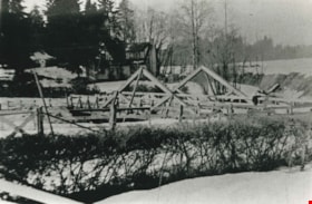
New Brunette River dam construction
https://search.heritageburnaby.ca/link/archivedescription35465
- Repository
- City of Burnaby Archives
- Date
- 1931 (date of original), copied 1986
- Collection/Fonds
- Burnaby Historical Society fonds
- Description Level
- Item
- Physical Description
- 1 photograph : b&w ; 12.7 x 17.8 cm print
- Scope and Content
- Photograph of the construction of new Brunette River dam and Cariboo Road bridge.
- Repository
- City of Burnaby Archives
- Date
- 1931 (date of original), copied 1986
- Collection/Fonds
- Burnaby Historical Society fonds
- Subseries
- Pioneer Tales subseries
- Physical Description
- 1 photograph : b&w ; 12.7 x 17.8 cm print
- Description Level
- Item
- Record No.
- 204-323
- Access Restriction
- No restrictions
- Reproduction Restriction
- No known restrictions
- Accession Number
- BHS1988-03
- Scope and Content
- Photograph of the construction of new Brunette River dam and Cariboo Road bridge.
- Media Type
- Photograph
- Notes
- Title based on contents of photograph
- Historic Neighbourhood
- Burquitlam (Historic Neighbourhood)
- Planning Study Area
- Burnaby Lake Area
Images

![Harrison Hotel Club House, [between 1935 and 1940] thumbnail](/media/hpo/_Data/_Archives_Images/_Unrestricted/371/428-009.jpg?width=280)
Harrison Hotel Club House
https://search.heritageburnaby.ca/link/archivedescription65749
- Repository
- City of Burnaby Archives
- Date
- [between 1935 and 1940]
- Collection/Fonds
- Burnaby Historical Society fonds
- Description Level
- Item
- Physical Description
- 1 photograph : b&w hand-tinted into col. ; 16.5 x 24 cm [sight] matted in frame 24.5 x 32 cm
- Scope and Content
- Photograph of the 'Harrison Hotel Club House' believed to be in the village of Harrison Hot Springs, British Columbia.
- Repository
- City of Burnaby Archives
- Date
- [between 1935 and 1940]
- Collection/Fonds
- Burnaby Historical Society fonds
- Subseries
- Ettinger family subseries
- Physical Description
- 1 photograph : b&w hand-tinted into col. ; 16.5 x 24 cm [sight] matted in frame 24.5 x 32 cm
- Description Level
- Item
- Record No.
- 428-009
- Access Restriction
- No restrictions
- Reproduction Restriction
- No known restrictions
- Accession Number
- BHS2002-03
- Scope and Content
- Photograph of the 'Harrison Hotel Club House' believed to be in the village of Harrison Hot Springs, British Columbia.
- Subjects
- Structures - Bridges
- Geographic Features - Rivers
- Buildings - Commercial - Hotels and Motels
- Media Type
- Photograph
- Notes
- Title taken from note on verso of frame
- Note on verso of frame reads: "Harrison Hotel / Club House"
- 1 reference photograph accompanying
- Note on verso of reference photograph reads: "Harrison / Club House / approx 1935-40"
- 'Edmonds Studios' as possible photographer
Images
![Harrison Hotel Club House, [between 1935 and 1940] thumbnail](/media/hpo/_Data/_Archives_Images/_Unrestricted/371/428-009.jpg)

Alexandra Bridge in British Columbia
https://search.heritageburnaby.ca/link/archivedescription65748
- Repository
- City of Burnaby Archives
- Date
- 1936
- Collection/Fonds
- Burnaby Historical Society fonds
- Description Level
- Item
- Physical Description
- 1 photograph : b&w hand-tinted into col. ; 17.5 x 24.5 cm [sight] matted in frame 24.5 x 32 cm
- Scope and Content
- Photograph of the Alexandra Bridge in British Columbia. The Alexander Bridge crosses the Fraser Canyon, along the Cariboo Highway, two kilometres north of Spuzzum.
- Repository
- City of Burnaby Archives
- Date
- 1936
- Collection/Fonds
- Burnaby Historical Society fonds
- Subseries
- Ettinger family subseries
- Physical Description
- 1 photograph : b&w hand-tinted into col. ; 17.5 x 24.5 cm [sight] matted in frame 24.5 x 32 cm
- Description Level
- Item
- Record No.
- 428-007
- Access Restriction
- No restrictions
- Reproduction Restriction
- No known restrictions
- Accession Number
- BHS2002-03
- Scope and Content
- Photograph of the Alexandra Bridge in British Columbia. The Alexander Bridge crosses the Fraser Canyon, along the Cariboo Highway, two kilometres north of Spuzzum.
- Media Type
- Photograph
- Photographer
- Edmonds Studio
- Notes
- Title based on contents of photograph
- Note on verso of frame reads: "Spuzzum Bridge / Fraser Canyon"
- Note on recto of matte reads: "Edmonds Studio 1936"
Images


Alexandra Bridge in British Columbia
https://search.heritageburnaby.ca/link/archivedescription85920
- Repository
- City of Burnaby Archives
- Date
- 1933
- Collection/Fonds
- Burnaby Historical Society fonds
- Description Level
- Item
- Physical Description
- 1 photograph : sepia ; 5.5 x 10 cm
- Scope and Content
- Photograph of the Alexandra Bridge in British Columbia. The Alexander Bridge crosses the Fraser Canyon, along the Cariboo Highway, two kilometres north of Spuzzum.
- Repository
- City of Burnaby Archives
- Date
- 1933
- Collection/Fonds
- Burnaby Historical Society fonds
- Subseries
- Ettinger family subseries
- Physical Description
- 1 photograph : sepia ; 5.5 x 10 cm
- Description Level
- Item
- Record No.
- 428-008
- Access Restriction
- No restrictions
- Reproduction Restriction
- No known restrictions
- Accession Number
- BHS2002-03
- Scope and Content
- Photograph of the Alexandra Bridge in British Columbia. The Alexander Bridge crosses the Fraser Canyon, along the Cariboo Highway, two kilometres north of Spuzzum.
- Media Type
- Photograph
- Notes
- Title based on contents of photograph
- Note on verso of photograph reads: "Alexander [sic] Bridge / 1933"
Images


Boat coming through locks
https://search.heritageburnaby.ca/link/museumdescription19435
- Repository
- Burnaby Village Museum
- Date
- 11 Oct. 1936
- Collection/Fonds
- Hawkshaw family fonds
- Description Level
- Item
- Physical Description
- 1 photograph : sepia ; 6.5 x 9 cm
- Scope and Content
- Photograph of a boat towing a log boom and coming through the Hiram M. Chittenden Locks (Ballard Locks) in Salmon Bay in Seattle, Washington's Ship Canal. The locks link Lake Washington to Puget Sound. The Salmon Bay Bridge is visible in the background spanning Salmon Bay.
- Repository
- Burnaby Village Museum
- Collection/Fonds
- Hawkshaw family fonds
- Description Level
- Item
- Physical Description
- 1 photograph : sepia ; 6.5 x 9 cm
- Scope and Content
- Photograph of a boat towing a log boom and coming through the Hiram M. Chittenden Locks (Ballard Locks) in Salmon Bay in Seattle, Washington's Ship Canal. The locks link Lake Washington to Puget Sound. The Salmon Bay Bridge is visible in the background spanning Salmon Bay.
- Subjects
- Transportation - Boats
- Geographic Features - Natural Waterways
- Geographic Features - Channels
- Geographic Features - Bays
- Structures - Bridges
- Water Control
- Accession Code
- BV996.6.119
- Access Restriction
- No restrictions
- Reproduction Restriction
- No known restrictions
- Date
- 11 Oct. 1936
- Media Type
- Photograph
- Scan Resolution
- 600
- Scan Date
- 2023-02-06
- Notes
- Title based on contents of photograph
- Caption beneath photograph reads: "COMING IN"
- Caption of album page reads: "Oct 11/36 / THANKSGIVING / SEATTLE"
- Photograph is part of photograph album BV996.6.1
Images

![Bridge and trail in Robert Burnaby Park, [between 1933 and 1947] (date of original), copied 2014 thumbnail](/media/hpo/_Data/_Archives_Images/_Unrestricted/580/581-012.jpg?width=280)
Bridge and trail in Robert Burnaby Park
https://search.heritageburnaby.ca/link/archivedescription88406
- Repository
- City of Burnaby Archives
- Date
- [between 1933 and 1947] (date of original), copied 2014
- Collection/Fonds
- James Massey family fonds
- Description Level
- Item
- Physical Description
- 1 photograph (tiff) : sepia ; 600 dpi
- Scope and Content
- Photograph of a trail in Robert Burnaby Park with a bridge in the middle ground and stairs leading to higher ground. The bridge and trail are surrounded by lush foliage and trees.
- Repository
- City of Burnaby Archives
- Date
- [between 1933 and 1947] (date of original), copied 2014
- Collection/Fonds
- James Massey family fonds
- Physical Description
- 1 photograph (tiff) : sepia ; 600 dpi
- Description Level
- Item
- Record No.
- 581-012
- Access Restriction
- No restrictions
- Reproduction Restriction
- No known restrictions
- Accession Number
- 2014-34
- Scope and Content
- Photograph of a trail in Robert Burnaby Park with a bridge in the middle ground and stairs leading to higher ground. The bridge and trail are surrounded by lush foliage and trees.
- Media Type
- Photograph
- Notes
- Title based on contents of photograph
- Historic Neighbourhood
- East Burnaby (Historic Neighbourhood)
- Planning Study Area
- Lakeview-Mayfield Area
Images
![Bridge and trail in Robert Burnaby Park, [between 1933 and 1947] (date of original), copied 2014 thumbnail](/media/hpo/_Data/_Archives_Images/_Unrestricted/580/581-012.jpg)
![Bridge over the Cottonwood River, [1935] thumbnail](/media/hpo/_Data/_Archives_Images/_Unrestricted/001/020-063.jpg?width=280)
Bridge over the Cottonwood River
https://search.heritageburnaby.ca/link/archivedescription34356
- Repository
- City of Burnaby Archives
- Date
- [1935]
- Collection/Fonds
- Burnaby Historical Society fonds
- Description Level
- Item
- Physical Description
- 1 photograph : b&w ; 5.9 x 11.7 cm
- Scope and Content
- Photograph of the wooden bridge that spanned the Cottonwood River at Cottonwood Flats (between Quesnel and Barkerville). The bridge was built in the mid-thirties.
- Repository
- City of Burnaby Archives
- Date
- [1935]
- Collection/Fonds
- Burnaby Historical Society fonds
- Subseries
- Peers family subseries
- Physical Description
- 1 photograph : b&w ; 5.9 x 11.7 cm
- Description Level
- Item
- Record No.
- 020-063
- Access Restriction
- No restrictions
- Reproduction Restriction
- No known restrictions
- Accession Number
- BHS2007-04
- Scope and Content
- Photograph of the wooden bridge that spanned the Cottonwood River at Cottonwood Flats (between Quesnel and Barkerville). The bridge was built in the mid-thirties.
- Media Type
- Photograph
- Notes
- Title based on caption accompanying photograph
Images
![Bridge over the Cottonwood River, [1935] thumbnail](/media/hpo/_Data/_Archives_Images/_Unrestricted/001/020-063.jpg)
![Bridge over the Cottonwood River at Cottonwood Flats, [1935] thumbnail](/media/hpo/_Data/_Archives_Images/_Unrestricted/001/020-062.jpg?width=280)
Bridge over the Cottonwood River at Cottonwood Flats
https://search.heritageburnaby.ca/link/archivedescription34355
- Repository
- City of Burnaby Archives
- Date
- [1935]
- Collection/Fonds
- Burnaby Historical Society fonds
- Description Level
- Item
- Physical Description
- 1 photograph : b&w ; 5.9 x 9 cm
- Scope and Content
- Photograph of the wooden bridge that spanned the Cottonwood River at Cottonwood Flats (between Quesnel and Barkerville). The bridge was built in the mid-thirties.
- Repository
- City of Burnaby Archives
- Date
- [1935]
- Collection/Fonds
- Burnaby Historical Society fonds
- Subseries
- Peers family subseries
- Physical Description
- 1 photograph : b&w ; 5.9 x 9 cm
- Description Level
- Item
- Record No.
- 020-062
- Access Restriction
- No restrictions
- Reproduction Restriction
- No known restrictions
- Accession Number
- BHS2007-04
- Scope and Content
- Photograph of the wooden bridge that spanned the Cottonwood River at Cottonwood Flats (between Quesnel and Barkerville). The bridge was built in the mid-thirties.
- Subjects
- Structures - Bridges
- Media Type
- Photograph
- Notes
- Title based on caption accompanying photograph
Images
![Bridge over the Cottonwood River at Cottonwood Flats, [1935] thumbnail](/media/hpo/_Data/_Archives_Images/_Unrestricted/001/020-062.jpg)
![Bridges in Robert Burnaby Park, [between 1933 and 1947] (date of original), copied 2014 thumbnail](/media/hpo/_Data/_Archives_Images/_Unrestricted/580/581-013.jpg?width=280)
Bridges in Robert Burnaby Park
https://search.heritageburnaby.ca/link/archivedescription88407
- Repository
- City of Burnaby Archives
- Date
- [between 1933 and 1947] (date of original), copied 2014
- Collection/Fonds
- James Massey family fonds
- Description Level
- Item
- Physical Description
- 1 photograph (tiff) : sepia ; 600 dpi
- Scope and Content
- Photograph of bridges in Robert Burnaby Park. Photograph is taken from a bridge in the foreground looking onto lush foliage and trees with another bridge in the distance.
- Repository
- City of Burnaby Archives
- Date
- [between 1933 and 1947] (date of original), copied 2014
- Collection/Fonds
- James Massey family fonds
- Physical Description
- 1 photograph (tiff) : sepia ; 600 dpi
- Description Level
- Item
- Record No.
- 581-013
- Access Restriction
- No restrictions
- Reproduction Restriction
- No known restrictions
- Accession Number
- 2014-34
- Scope and Content
- Photograph of bridges in Robert Burnaby Park. Photograph is taken from a bridge in the foreground looking onto lush foliage and trees with another bridge in the distance.
- Subjects
- Structures - Bridges
- Media Type
- Photograph
- Notes
- Title based on contents of photograph
- Historic Neighbourhood
- East Burnaby (Historic Neighbourhood)
- Planning Study Area
- Lakeview-Mayfield Area
Images
![Bridges in Robert Burnaby Park, [between 1933 and 1947] (date of original), copied 2014 thumbnail](/media/hpo/_Data/_Archives_Images/_Unrestricted/580/581-013.jpg)
![Burrard Inlet, [1930] thumbnail](/media/hpo/_Data/_Archives_Images/_Unrestricted/371/443-013.jpg?width=280)
Burrard Inlet
https://search.heritageburnaby.ca/link/archivedescription38446
- Repository
- City of Burnaby Archives
- Date
- [1930]
- Collection/Fonds
- Burnaby Historical Society fonds
- Description Level
- Item
- Physical Description
- 1 photograph : b&w ; 6.4 x 9 cm
- Scope and Content
- Photograph looking west from 410 North Hythe Avenue towards Burrard Inlet. The Second Narrows Bridge can be seen faintly in the background.
- Repository
- City of Burnaby Archives
- Date
- [1930]
- Collection/Fonds
- Burnaby Historical Society fonds
- Subseries
- Photographs subseries
- Physical Description
- 1 photograph : b&w ; 6.4 x 9 cm
- Description Level
- Item
- Record No.
- 443-013
- Access Restriction
- No restrictions
- Reproduction Restriction
- No known restrictions
- Accession Number
- BHS2002-13
- Scope and Content
- Photograph looking west from 410 North Hythe Avenue towards Burrard Inlet. The Second Narrows Bridge can be seen faintly in the background.
- Media Type
- Photograph
- Notes
- Title based on contents of photograph
- Geographic Access
- Hythe Avenue North
- Street Address
- 410 Hythe Avenue North
- Historic Neighbourhood
- Capitol Hill (Historic Neighbourhood)
- Planning Study Area
- Capitol Hill Area
Images
![Burrard Inlet, [1930] thumbnail](/media/hpo/_Data/_Archives_Images/_Unrestricted/371/443-013.jpg)
![Burrard Inlet, [1930] thumbnail](/media/hpo/_Data/_Archives_Images/_Unrestricted/371/443-014.jpg?width=280)
Burrard Inlet
https://search.heritageburnaby.ca/link/archivedescription38447
- Repository
- City of Burnaby Archives
- Date
- [1930]
- Collection/Fonds
- Burnaby Historical Society fonds
- Description Level
- Item
- Physical Description
- 1 photograph : b&w ; 6.3 x 9 cm
- Scope and Content
- Photograph taken from 410 North Hythe Avenue looking towards the Burrard Inlet. The Second Narrows Bridge can be seen faintly in the background.
- Repository
- City of Burnaby Archives
- Date
- [1930]
- Collection/Fonds
- Burnaby Historical Society fonds
- Subseries
- Photographs subseries
- Physical Description
- 1 photograph : b&w ; 6.3 x 9 cm
- Description Level
- Item
- Record No.
- 443-014
- Access Restriction
- No restrictions
- Reproduction Restriction
- No known restrictions
- Accession Number
- BHS2002-13
- Scope and Content
- Photograph taken from 410 North Hythe Avenue looking towards the Burrard Inlet. The Second Narrows Bridge can be seen faintly in the background.
- Media Type
- Photograph
- Notes
- Title based on contents of photograph.
- Geographic Access
- Hythe Avenue North
- Street Address
- 410 Hythe Avenue North
- Historic Neighbourhood
- Capitol Hill (Historic Neighbourhood)
- Planning Study Area
- Capitol Hill Area
Images
![Burrard Inlet, [1930] thumbnail](/media/hpo/_Data/_Archives_Images/_Unrestricted/371/443-014.jpg)
![Canadian National Railway Bridge, [between 1930 and 1934] (date of original), copied 1991 thumbnail](/media/hpo/_Data/_Archives_Images/_Unrestricted/370/370-059.jpg?width=280)
Canadian National Railway Bridge
https://search.heritageburnaby.ca/link/archivedescription37471
- Repository
- City of Burnaby Archives
- Date
- [between 1930 and 1934] (date of original), copied 1991
- Collection/Fonds
- Burnaby Historical Society fonds
- Description Level
- Item
- Physical Description
- 1 photograph : b&w ; 2.7 x 4.1 cm print on contact sheet 20.2 x 25.3 cm
- Scope and Content
- Photograph of the Canadian National Railway (CNR) Bridge over the Fraser River open to allow ships through. No boats are visible.
- Repository
- City of Burnaby Archives
- Date
- [between 1930 and 1934] (date of original), copied 1991
- Collection/Fonds
- Burnaby Historical Society fonds
- Subseries
- Burnaby Image Bank subseries
- Physical Description
- 1 photograph : b&w ; 2.7 x 4.1 cm print on contact sheet 20.2 x 25.3 cm
- Description Level
- Item
- Record No.
- 370-059
- Access Restriction
- No restrictions
- Reproduction Restriction
- No known restrictions
- Accession Number
- BHS1999-03
- Scope and Content
- Photograph of the Canadian National Railway (CNR) Bridge over the Fraser River open to allow ships through. No boats are visible.
- Media Type
- Photograph
- Photographer
- Bellinger, Bernard
- Notes
- Title based on contents of photograph
- 1 b&w copy negative accompanying
- Historic Neighbourhood
- Fraser Arm (Historic Neighbourhood)
- Planning Study Area
- Big Bend Area
Images
![Canadian National Railway Bridge, [between 1930 and 1934] (date of original), copied 1991 thumbnail](/media/hpo/_Data/_Archives_Images/_Unrestricted/370/370-059.jpg)
![Capilano suspension bridge, [1938 or 1939] thumbnail](/media/hpo/_Data/_BVM_Images/2017/201700280037_001.jpg?width=280)
Capilano suspension bridge
https://search.heritageburnaby.ca/link/museumdescription4240
- Repository
- Burnaby Village Museum
- Date
- [1938 or 1939]
- Collection/Fonds
- Burnaby Village Museum Photograph collection
- Description Level
- Item
- Physical Description
- 1 photograph : b&w ; 7.5 x 12 cm
- Scope and Content
- Photograph of the Capilano Suspension Bridge taken from below and looking north.
- Repository
- Burnaby Village Museum
- Collection/Fonds
- Burnaby Village Museum Photograph collection
- Description Level
- Item
- Physical Description
- 1 photograph : b&w ; 7.5 x 12 cm
- Material Details
- Handwritten text reading: Capilano Suspension Bridge" on back. "28" stamped on back.
- Scope and Content
- Photograph of the Capilano Suspension Bridge taken from below and looking north.
- Subjects
- Structures - Bridges
- Accession Code
- BV017.28.37
- Access Restriction
- No restrictions
- Reproduction Restriction
- No known restrictions
- Date
- [1938 or 1939]
- Media Type
- Photograph
- Scan Resolution
- 600
- Scan Date
- 06-Mar-2018
- Notes
- Title based on contents of photograph
Images
![Capilano suspension bridge, [1938 or 1939] thumbnail](/media/hpo/_Data/_BVM_Images/2017/201700280037_001.jpg)
![Carquinez bridge over Carquinez Strait, [1936] (date of original), copied 1996 thumbnail](/media/hpo/_Data/_BVM_Images/2022/2022_0002_0035_001.jpg?width=280)
Carquinez bridge over Carquinez Strait
https://search.heritageburnaby.ca/link/museumdescription18105
- Repository
- Burnaby Village Museum
- Date
- [1936] (date of original), copied 1996
- Collection/Fonds
- Burnaby Village Museum fonds
- Description Level
- Item
- Physical Description
- 1 photograph : b&w negative ; 35 mm
- Scope and Content
- Photograph of the Carquinez bridge over the Carquinez Strait at the northeastern end of San Francisco Bay. Photograph was taken while Dora and Jimmy Robertson traveled to the United States to assist in bringing the C.W. Parker no. 119 carousel to Happyland in Vancouver after it was purchased.
- Repository
- Burnaby Village Museum
- Collection/Fonds
- Burnaby Village Museum fonds
- Subseries
- Carousel photographs subseries
- Description Level
- Item
- Physical Description
- 1 photograph : b&w negative ; 35 mm
- Scope and Content
- Photograph of the Carquinez bridge over the Carquinez Strait at the northeastern end of San Francisco Bay. Photograph was taken while Dora and Jimmy Robertson traveled to the United States to assist in bringing the C.W. Parker no. 119 carousel to Happyland in Vancouver after it was purchased.
- Subjects
- Structures - Bridges
- Accession Code
- BV022.2.35
- Access Restriction
- No restrictions
- Reproduction Restriction
- No known restrictions
- Date
- [1936] (date of original), copied 1996
- Media Type
- Photograph
- Scan Resolution
- 2400
- Scan Date
- 2021-08-17
- Notes
- Title based on contents of photograph
- Photograph from Roll P96-3, negative #8
- Photograph copied from Robertson family album
Images
![Carquinez bridge over Carquinez Strait, [1936] (date of original), copied 1996 thumbnail](/media/hpo/_Data/_BVM_Images/2022/2022_0002_0035_001.jpg)
![Detail of First Narrows Bridge, [1938] thumbnail](/media/hpo/_Data/_BVM_Images/1996/1996_0006_0232_001.jpg?width=280)
Detail of First Narrows Bridge
https://search.heritageburnaby.ca/link/museumdescription19525
- Repository
- Burnaby Village Museum
- Date
- [1938]
- Collection/Fonds
- Hawkshaw family fonds
- Description Level
- Item
- Physical Description
- 1 photograph : sepia ; 6.5 x 9 cm
- Scope and Content
- Photograph detail of steel structure of the First Narrows Bridge (Lions Gate Bridge) that crosses the first narrows of Burrard Inlet connecting Vancouver to the North Shore.
- Repository
- Burnaby Village Museum
- Collection/Fonds
- Hawkshaw family fonds
- Description Level
- Item
- Physical Description
- 1 photograph : sepia ; 6.5 x 9 cm
- Scope and Content
- Photograph detail of steel structure of the First Narrows Bridge (Lions Gate Bridge) that crosses the first narrows of Burrard Inlet connecting Vancouver to the North Shore.
- Subjects
- Structures - Bridges
- Accession Code
- BV996.6.232
- Access Restriction
- No restrictions
- Reproduction Restriction
- No known restrictions
- Date
- [1938]
- Media Type
- Photograph
- Scan Resolution
- 600
- Scan Date
- 2023-02-16
- Notes
- Title based on contents of photograph
- Caption on photograph album page reads: "1st Narrows Bridge"
- Photograph is part of photograph album BV996.6.1
Images
![Detail of First Narrows Bridge, [1938] thumbnail](/media/hpo/_Data/_BVM_Images/1996/1996_0006_0232_001.jpg)
![Detail of First Narrows Bridge, [1938] thumbnail](/media/hpo/_Data/_BVM_Images/1996/1996_0006_0235_001.jpg?width=280)
Detail of First Narrows Bridge
https://search.heritageburnaby.ca/link/museumdescription19528
- Repository
- Burnaby Village Museum
- Date
- [1938]
- Collection/Fonds
- Hawkshaw family fonds
- Description Level
- Item
- Physical Description
- 1 photograph : sepia ; 6.5 x 9 cm
- Scope and Content
- Photograph detail of steel structure of the First Narrows Bridge (Lions Gate Bridge) that crosses the first narrows of Burrard Inlet connecting Vancouver to the North Shore.
- Repository
- Burnaby Village Museum
- Collection/Fonds
- Hawkshaw family fonds
- Description Level
- Item
- Physical Description
- 1 photograph : sepia ; 6.5 x 9 cm
- Scope and Content
- Photograph detail of steel structure of the First Narrows Bridge (Lions Gate Bridge) that crosses the first narrows of Burrard Inlet connecting Vancouver to the North Shore.
- Subjects
- Structures - Bridges
- Accession Code
- BV996.6.235
- Access Restriction
- No restrictions
- Reproduction Restriction
- No known restrictions
- Date
- [1938]
- Media Type
- Photograph
- Scan Resolution
- 600
- Scan Date
- 2023-02-16
- Notes
- Title based on contents of photograph
- Photograph is part of photograph album BV996.6.1
Images
![Detail of First Narrows Bridge, [1938] thumbnail](/media/hpo/_Data/_BVM_Images/1996/1996_0006_0235_001.jpg)
![First Narrows Bridge, [1938] thumbnail](/media/hpo/_Data/_BVM_Images/1996/1996_0006_0233_001.jpg?width=280)
First Narrows Bridge
https://search.heritageburnaby.ca/link/museumdescription19526
- Repository
- Burnaby Village Museum
- Date
- [1938]
- Collection/Fonds
- Hawkshaw family fonds
- Description Level
- Item
- Physical Description
- 1 photograph : sepia ; 6.5 x 9 cm
- Scope and Content
- Photograph of the First Narrows Bridge (Lions Gate Bridge). Photograph is taken from the shore looking west towards the suspension bridge which spans the first narrows of Burrard Inet connecting the City of Vancouver to the North Shore.
- Repository
- Burnaby Village Museum
- Collection/Fonds
- Hawkshaw family fonds
- Description Level
- Item
- Physical Description
- 1 photograph : sepia ; 6.5 x 9 cm
- Scope and Content
- Photograph of the First Narrows Bridge (Lions Gate Bridge). Photograph is taken from the shore looking west towards the suspension bridge which spans the first narrows of Burrard Inet connecting the City of Vancouver to the North Shore.
- Accession Code
- BV996.6.233
- Access Restriction
- No restrictions
- Reproduction Restriction
- No known restrictions
- Date
- [1938]
- Media Type
- Photograph
- Scan Resolution
- 600
- Scan Date
- 2023-02-16
- Notes
- Title based on contents of photograph
- Photograph is part of photograph album BV996.6.1
Images
![First Narrows Bridge, [1938] thumbnail](/media/hpo/_Data/_BVM_Images/1996/1996_0006_0233_001.jpg)
![First Narrows Bridge, [1938] thumbnail](/media/hpo/_Data/_BVM_Images/1996/1996_0006_0234_001.jpg?width=280)
First Narrows Bridge
https://search.heritageburnaby.ca/link/museumdescription19527
- Repository
- Burnaby Village Museum
- Date
- [1938]
- Collection/Fonds
- Hawkshaw family fonds
- Description Level
- Item
- Physical Description
- 1 photograph : sepia ; 6.5 x 9 cm
- Scope and Content
- Photograph of the First Narrows Bridge (Lions Gate Bridge). Photograph is taken from the shore looking west towards the suspension bridge which spans the first narrows of Burrard Inet connecting the City of Vancouver to the North Shore.
- Repository
- Burnaby Village Museum
- Collection/Fonds
- Hawkshaw family fonds
- Description Level
- Item
- Physical Description
- 1 photograph : sepia ; 6.5 x 9 cm
- Scope and Content
- Photograph of the First Narrows Bridge (Lions Gate Bridge). Photograph is taken from the shore looking west towards the suspension bridge which spans the first narrows of Burrard Inet connecting the City of Vancouver to the North Shore.
- Accession Code
- BV996.6.234
- Access Restriction
- No restrictions
- Reproduction Restriction
- No known restrictions
- Date
- [1938]
- Media Type
- Photograph
- Scan Resolution
- 600
- Scan Date
- 2023-02-16
- Notes
- Title based on contents of photograph
- Photograph is part of photograph album BV996.6.1
Images
![First Narrows Bridge, [1938] thumbnail](/media/hpo/_Data/_BVM_Images/1996/1996_0006_0234_001.jpg)