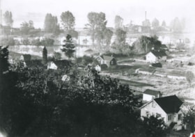
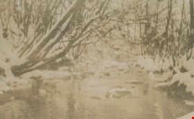
More like 'Deer Lake Brook in flood'
Narrow Results By
Subject
- Accidents 4
- Accidents - Automobile Accidents 2
- Advertising Medium - Signs and Signboards 20
- Aerial Photographs 34
- Agricultural Tools and Equipment 2
- Agricultural Tools and Equipment - Gardening Equipment 4
- Agricultural Tools and Equipment - Plows 2
- Agriculture 2
- Agriculture - Farms 11
- Agriculture - Fruit and Berries 2
- Animals 4
- Animals - Bears 2

Deer Lake Brook in flood
https://search.heritageburnaby.ca/link/archivedescription39389
- Repository
- City of Burnaby Archives
- Date
- 1916
- Collection/Fonds
- Peers Family and Hill Family fonds
- Description Level
- Item
- Physical Description
- 1 photograph : b&w ; 6 x 9.8 cm on page 24.5 x 32.5 cm (pasted in album)
- Scope and Content
- Photograph of Deer Lake Creek; historically known as Deer Lake Creek, in flood.
- Repository
- City of Burnaby Archives
- Date
- 1916
- Collection/Fonds
- Peers Family and Hill Family fonds
- Physical Description
- 1 photograph : b&w ; 6 x 9.8 cm on page 24.5 x 32.5 cm (pasted in album)
- Description Level
- Item
- Record No.
- 477-708
- Access Restriction
- No restrictions
- Reproduction Restriction
- No known restrictions
- Accession Number
- 2007-12
- Scope and Content
- Photograph of Deer Lake Creek; historically known as Deer Lake Creek, in flood.
- Media Type
- Photograph
- Notes
- Title based on caption accompanying photograph
- Geographic Access
- Deer Lake Brook
- Historic Neighbourhood
- Burnaby Lake (Historic Neighbourhood)
Images


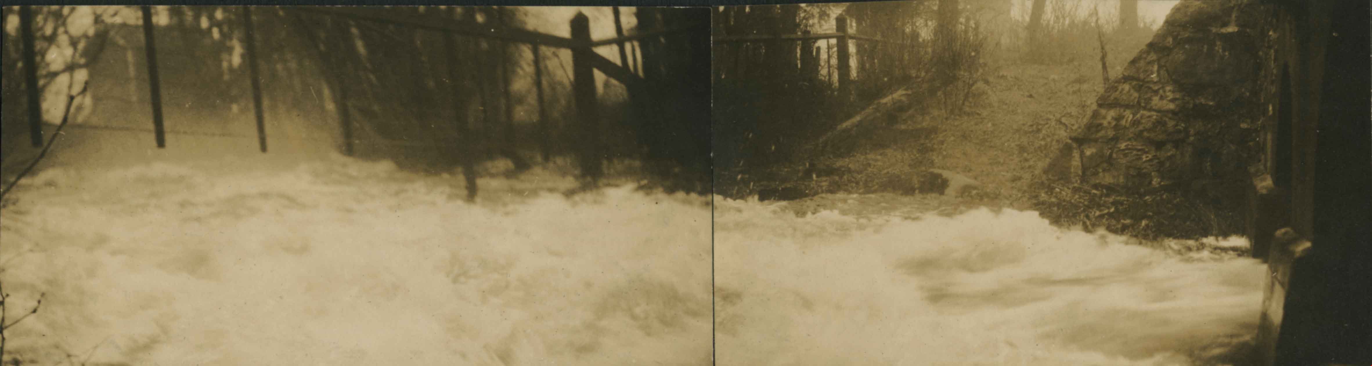
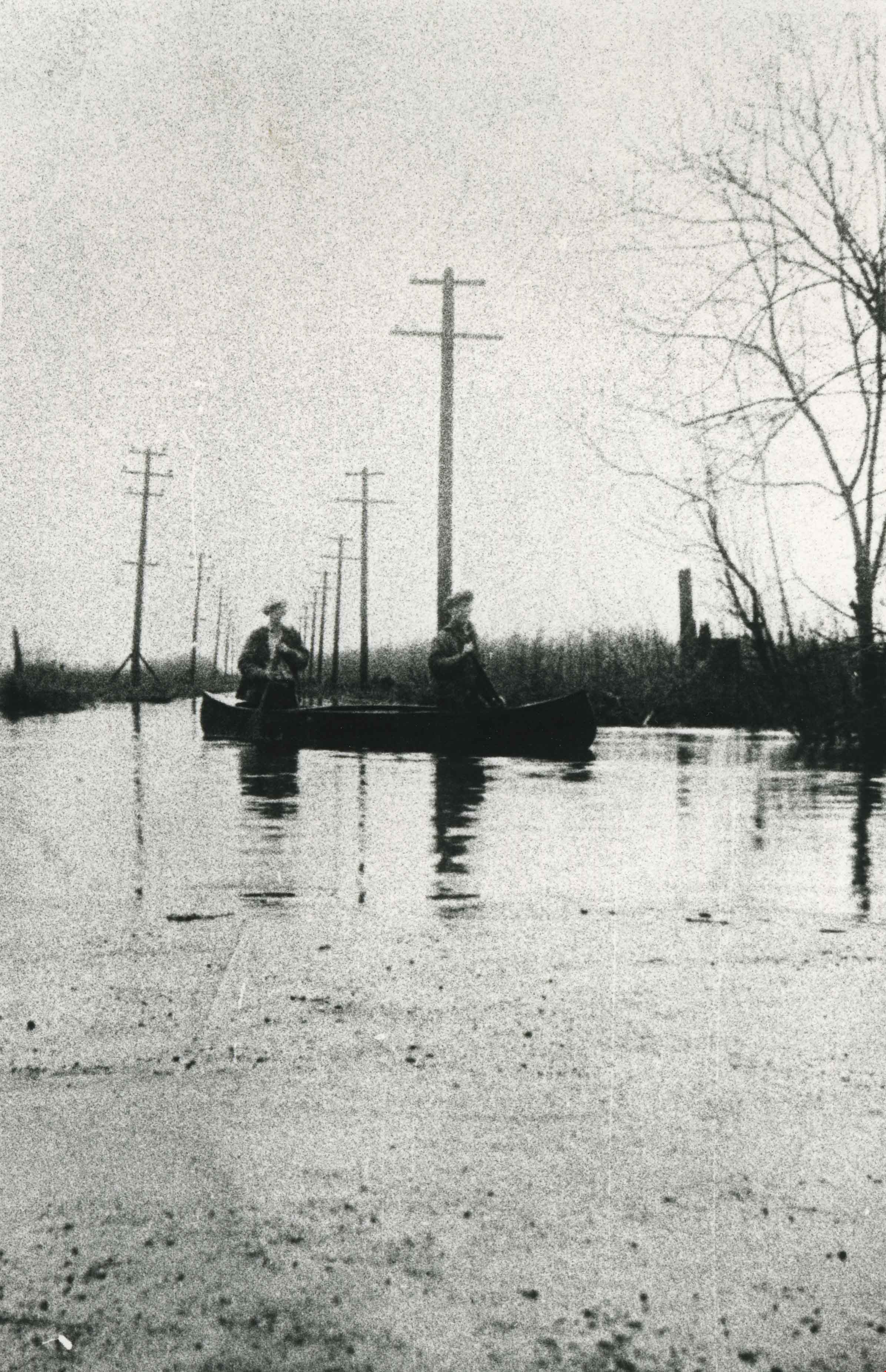
Panorama of Deer Lake Brook in flood
https://search.heritageburnaby.ca/link/archivedescription39388
- Repository
- City of Burnaby Archives
- Date
- 1916
- Collection/Fonds
- Peers Family and Hill Family fonds
- Description Level
- Item
- Physical Description
- 2 photographs : sepia panorama ; 5.5 x 10.4 cm on page 24.5 x 32.5 cm (pasted in album)
- Scope and Content
- Photographic panorama of Deer Lake Creek; historically known as Deer Lake Brook, in flood.
- Repository
- City of Burnaby Archives
- Date
- 1916
- Collection/Fonds
- Peers Family and Hill Family fonds
- Physical Description
- 2 photographs : sepia panorama ; 5.5 x 10.4 cm on page 24.5 x 32.5 cm (pasted in album)
- Description Level
- Item
- Record No.
- 477-707
- Access Restriction
- No restrictions
- Reproduction Restriction
- No known restrictions
- Accession Number
- 2007-12
- Scope and Content
- Photographic panorama of Deer Lake Creek; historically known as Deer Lake Brook, in flood.
- Media Type
- Photograph
- Notes
- Title based on caption accompanying photograph
- Geographic Access
- Deer Lake Brook
- Historic Neighbourhood
- Burnaby Lake (Historic Neighbourhood)
Images
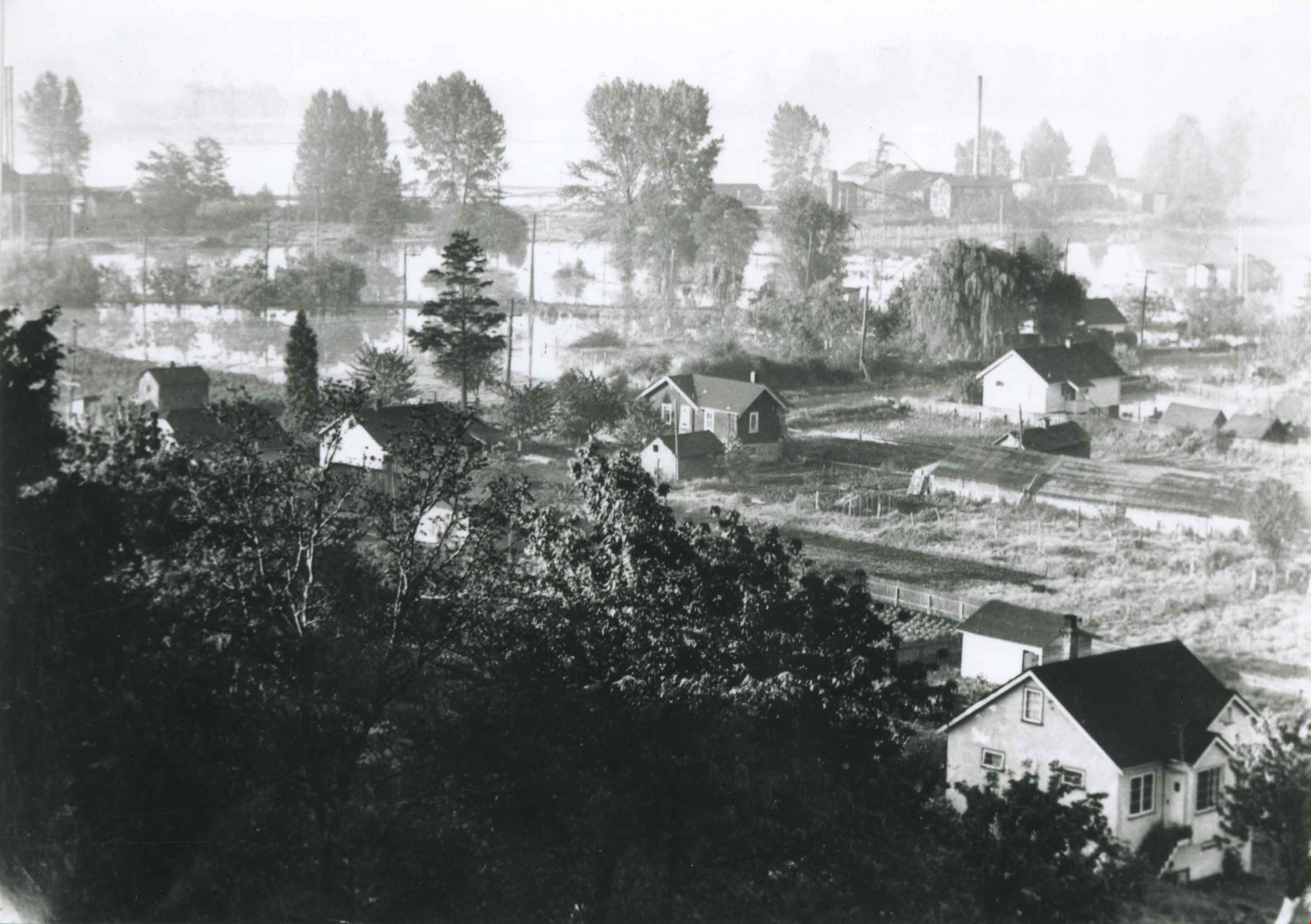
Byrne Flats flood
https://search.heritageburnaby.ca/link/archivedescription36857
- Repository
- City of Burnaby Archives
- Date
- 1948
- Collection/Fonds
- Burnaby Historical Society fonds
- Description Level
- Item
- Physical Description
- 1 photograph : b&w ; 9 x 12 cm print
- Scope and Content
- Photograph of Byrne Flats during the 1948 Fraser River flood.
- Repository
- City of Burnaby Archives
- Date
- 1948
- Collection/Fonds
- Burnaby Historical Society fonds
- Subseries
- Burnaby Centennial Anthology subseries
- Physical Description
- 1 photograph : b&w ; 9 x 12 cm print
- Description Level
- Item
- Record No.
- 315-315
- Access Restriction
- No restrictions
- Reproduction Restriction
- No known restrictions
- Accession Number
- BHS1994-04
- Scope and Content
- Photograph of Byrne Flats during the 1948 Fraser River flood.
- Media Type
- Photograph
- Notes
- Title based on contents of photograph
- Geographic Access
- Trapp Avenue
- Historic Neighbourhood
- Fraser Arm (Historic Neighbourhood)
- Planning Study Area
- Big Bend Area
Images

Byrne Flats flood
https://search.heritageburnaby.ca/link/archivedescription36858
- Repository
- City of Burnaby Archives
- Date
- 1948
- Collection/Fonds
- Burnaby Historical Society fonds
- Description Level
- Item
- Physical Description
- 1 photograph : b&w ; 9 x 12.5 cm print
- Scope and Content
- Photograph of Byrne Flats during the 1948 Fraser River flood.
- Repository
- City of Burnaby Archives
- Date
- 1948
- Collection/Fonds
- Burnaby Historical Society fonds
- Subseries
- Burnaby Centennial Anthology subseries
- Physical Description
- 1 photograph : b&w ; 9 x 12.5 cm print
- Description Level
- Item
- Record No.
- 315-316
- Access Restriction
- No restrictions
- Reproduction Restriction
- No known restrictions
- Accession Number
- BHS1994-04
- Scope and Content
- Photograph of Byrne Flats during the 1948 Fraser River flood.
- Media Type
- Photograph
- Notes
- Title based on contents of photograph
- Geographic Access
- Trapp Avenue
- Historic Neighbourhood
- Fraser Arm (Historic Neighbourhood)
- Planning Study Area
- Big Bend Area
Images

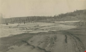
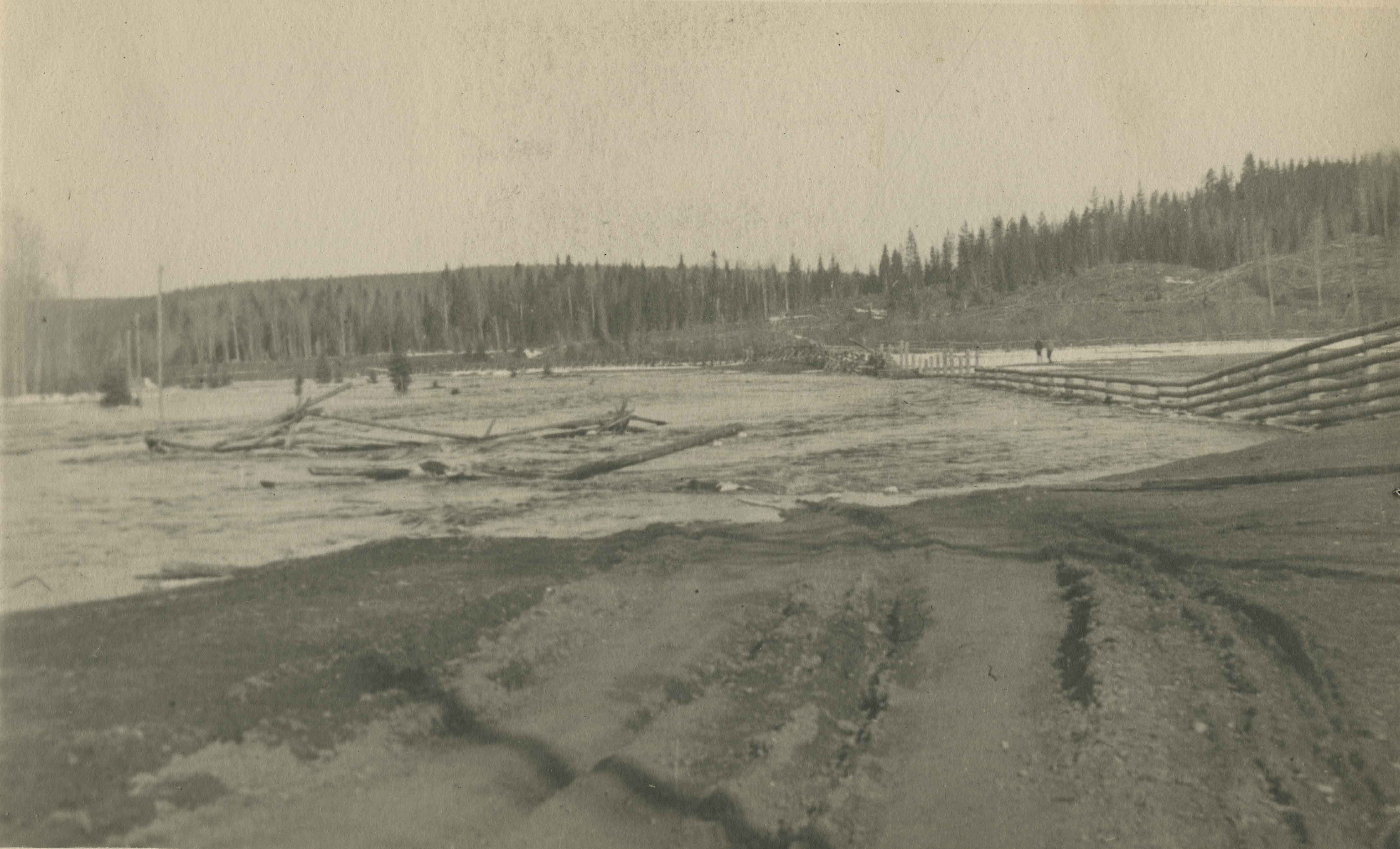
Cottonwood River flood
https://search.heritageburnaby.ca/link/archivedescription34447
- Repository
- City of Burnaby Archives
- Date
- 1937
- Collection/Fonds
- Burnaby Historical Society fonds
- Description Level
- Item
- Physical Description
- 1 photograph : b&w ; 12.3 x 19.7 cm on page 17.5 x 26 cm
- Scope and Content
- Photograph of the flood of the Cottonwood River. Water can be seen flooding through a wooden fence on the riverbank and two men are visible walking to the right. Trees and other debris are floating down the river.
- Repository
- City of Burnaby Archives
- Date
- 1937
- Collection/Fonds
- Burnaby Historical Society fonds
- Subseries
- Peers family subseries
- Physical Description
- 1 photograph : b&w ; 12.3 x 19.7 cm on page 17.5 x 26 cm
- Description Level
- Item
- Record No.
- 020-154
- Access Restriction
- No restrictions
- Reproduction Restriction
- No known restrictions
- Accession Number
- BHS2007-04
- Scope and Content
- Photograph of the flood of the Cottonwood River. Water can be seen flooding through a wooden fence on the riverbank and two men are visible walking to the right. Trees and other debris are floating down the river.
- Media Type
- Photograph
- Notes
- Title based on caption accompanying photograph
Images
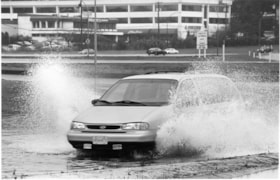
![Willingdon on-ramp flooding, [2005] thumbnail](/media/hpo/_Data/_Archives_Images/_Unrestricted/535/535-1860-1.jpg?width=280)
Willingdon on-ramp flooding
https://search.heritageburnaby.ca/link/archivedescription96163
- Repository
- City of Burnaby Archives
- Date
- [2005]
- Collection/Fonds
- Burnaby NewsLeader photograph collection
- Description Level
- File
- Physical Description
- 2 photographs (tiff) : col.
- Scope and Content
- File contains photographs of flooding at the Willingdon on-ramp to Highway 1 in Burnaby after a significant rainstorm. Photographs depict a worker placing pylons to close the on-ramp and cars attempting to drive through deep puddles by the highway.
- Repository
- City of Burnaby Archives
- Date
- [2005]
- Collection/Fonds
- Burnaby NewsLeader photograph collection
- Physical Description
- 2 photographs (tiff) : col.
- Description Level
- File
- Record No.
- 535-1860
- Access Restriction
- No restrictions
- Reproduction Restriction
- No restrictions
- Accession Number
- 2018-12
- Scope and Content
- File contains photographs of flooding at the Willingdon on-ramp to Highway 1 in Burnaby after a significant rainstorm. Photographs depict a worker placing pylons to close the on-ramp and cars attempting to drive through deep puddles by the highway.
- Media Type
- Photograph
- Photographer
- Bartel, Mario
- Notes
- Title based on caption
- Collected by editorial for use in a January 2005 issue of the Burnaby NewsLeader
- Caption from metadata for 535-1860-1: "A worker for Mainroad Contracting closes the Willingdon on-ramp to Highway 1 because of flooding during Monday's torrential rainstorm."
- Caption from metadata for 535-1860-2: "After two weeks of snow and cold temperatures, Lower Mainland drivers find themselves in familiar territory, plowing through deep puddles on Willingdon, just north of Highway 1."
- Geographic Access
- Willingdon Avenue
- Planning Study Area
- West Central Valley Area
Images
![Willingdon on-ramp flooding, [2005] thumbnail](/media/hpo/_Data/_Archives_Images/_Unrestricted/535/535-1860-1.jpg)
Deer Lake Brook
https://search.heritageburnaby.ca/link/archivedescription39321
- Repository
- City of Burnaby Archives
- Date
- 1922
- Collection/Fonds
- Peers Family and Hill Family fonds
- Description Level
- Item
- Physical Description
- 1 photograph : b&w ; 6 x 9.8 cm on page 24.5 x 32.5 cm (pasted in album)
- Scope and Content
- Photograph of Deer Lake Creek; historically known as Deer Lake Brook. The banks and trees are covered with snow.
- Repository
- City of Burnaby Archives
- Date
- 1922
- Collection/Fonds
- Peers Family and Hill Family fonds
- Physical Description
- 1 photograph : b&w ; 6 x 9.8 cm on page 24.5 x 32.5 cm (pasted in album)
- Description Level
- Item
- Record No.
- 477-640
- Access Restriction
- No restrictions
- Reproduction Restriction
- No known restrictions
- Accession Number
- 2007-12
- Scope and Content
- Photograph of Deer Lake Creek; historically known as Deer Lake Brook. The banks and trees are covered with snow.
- Media Type
- Photograph
- Notes
- Title based on contents of photograph
- Geographic Access
- Deer Lake Brook
Images

![Big Bend flood, [1999] thumbnail](/media/hpo/_Data/_Archives_Images/_Unrestricted/535/535-3167-1.jpg?width=280)
Big Bend flood
https://search.heritageburnaby.ca/link/archivedescription98087
- Repository
- City of Burnaby Archives
- Date
- [1999]
- Collection/Fonds
- Burnaby NewsLeader photograph collection
- Description Level
- File
- Physical Description
- 3 photographs (tiff) : col.
- Scope and Content
- File contains photographs of unidentified people after a flood in the Big Bend area. Photographs depict a person standing in a farm field and adjusting a plant at Wing Wong's Nursery, and another person wearing a hard hat and posing with a construction vehicle.
- Repository
- City of Burnaby Archives
- Date
- [1999]
- Collection/Fonds
- Burnaby NewsLeader photograph collection
- Physical Description
- 3 photographs (tiff) : col.
- Description Level
- File
- Record No.
- 535-3167
- Access Restriction
- No restrictions
- Reproduction Restriction
- No restrictions
- Accession Number
- 2018-12
- Scope and Content
- File contains photographs of unidentified people after a flood in the Big Bend area. Photographs depict a person standing in a farm field and adjusting a plant at Wing Wong's Nursery, and another person wearing a hard hat and posing with a construction vehicle.
- Subjects
- Agriculture - Farms
- Buildings - Agricultural - Nurseries
- Construction Tools and Equipment
- Natural Phenomena - Floods
- Media Type
- Photograph
- Notes
- Title based on original file name
- Collected by editorial for use in a May 1999 issue of the Burnaby NewsLeader
- Geographic Access
- Marine Drive
- Street Address
- 4892 Marine Drive
- Historic Neighbourhood
- Fraser Arm (Historic Neighbourhood)
- Planning Study Area
- Big Bend Area
Images
![Big Bend flood, [1999] thumbnail](/media/hpo/_Data/_Archives_Images/_Unrestricted/535/535-3167-1.jpg)
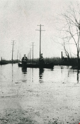
Burnaby Lake flooding
https://search.heritageburnaby.ca/link/archivedescription35571
- Repository
- City of Burnaby Archives
- Date
- 1932 (date of original), copied 1986
- Collection/Fonds
- Burnaby Historical Society fonds
- Description Level
- Item
- Physical Description
- 1 photograph : b&w ; 12.7 x 17.8 cm print
- Scope and Content
- Photograph taken the year of the big flood. Burnaby Lake rose and inundated Sperling Avenue, forcing people to canoe or boat along the avenue.
- Repository
- City of Burnaby Archives
- Date
- 1932 (date of original), copied 1986
- Collection/Fonds
- Burnaby Historical Society fonds
- Subseries
- Pioneer Tales subseries
- Physical Description
- 1 photograph : b&w ; 12.7 x 17.8 cm print
- Description Level
- Item
- Record No.
- 204-429
- Access Restriction
- No restrictions
- Reproduction Restriction
- No known restrictions
- Accession Number
- BHS1988-03
- Scope and Content
- Photograph taken the year of the big flood. Burnaby Lake rose and inundated Sperling Avenue, forcing people to canoe or boat along the avenue.
- Media Type
- Photograph
- Notes
- Title based on contents of photograph
- Geographic Access
- Sperling Avenue
- Historic Neighbourhood
- Burnaby Lake (Historic Neighbourhood)
- Planning Study Area
- Burnaby Lake Area
Images
Minivan driving through flooded street
https://search.heritageburnaby.ca/link/archivedescription78709
- Repository
- City of Burnaby Archives
- Date
- November 26, 1995
- Collection/Fonds
- Burnaby NewsLeader photograph collection
- Description Level
- Item
- Physical Description
- 1 photograph : b&w ; 15.5 x 24 cm
- Scope and Content
- Photograph of a minivan driving through deep water at the Willingdon Avenue off-ramp from Highway 1 after a week of heavy rain.
- Repository
- City of Burnaby Archives
- Date
- November 26, 1995
- Collection/Fonds
- Burnaby NewsLeader photograph collection
- Physical Description
- 1 photograph : b&w ; 15.5 x 24 cm
- Description Level
- Item
- Record No.
- 535-0069
- Access Restriction
- No restrictions
- Reproduction Restriction
- No reproduction permitted
- Accession Number
- 2012-11
- Scope and Content
- Photograph of a minivan driving through deep water at the Willingdon Avenue off-ramp from Highway 1 after a week of heavy rain.
- Media Type
- Photograph
- Photographer
- Bartel, Mario
- Notes
- Title based on contents of photograph
- Note in black and red ink on recto of photograph reads: "85% Bby 1 / Mario Bby 3308"
- Trim marks and/or reproduction instructions on recto (scan is cropped)
Images

![Walker family property, [1948] (date of original); 2013 (date of duplication) thumbnail](/media/hpo/_Data/_Archives_Images/_Unrestricted/550/557-012.jpg?width=280)
Walker family property
https://search.heritageburnaby.ca/link/archivedescription78751
- Repository
- City of Burnaby Archives
- Date
- [1948] (date of original); 2013 (date of duplication)
- Collection/Fonds
- Walker family fonds
- Description Level
- Item
- Physical Description
- 1 photograph (jpeg) : b&w ; 96 dpi
- Scope and Content
- Photograph of the Scotty and Elizabeth Walker family property at Twelfth Avenue in Burnaby flooded with rain that froze over. This photograph was taken looking towards Henley Street.
- Repository
- City of Burnaby Archives
- Date
- [1948] (date of original); 2013 (date of duplication)
- Collection/Fonds
- Walker family fonds
- Physical Description
- 1 photograph (jpeg) : b&w ; 96 dpi
- Description Level
- Item
- Record No.
- 557-012
- Access Restriction
- No restrictions
- Reproduction Restriction
- No known restrictions
- Accession Number
- 2013-15
- Scope and Content
- Photograph of the Scotty and Elizabeth Walker family property at Twelfth Avenue in Burnaby flooded with rain that froze over. This photograph was taken looking towards Henley Street.
- Subjects
- Natural Phenomena - Floods
- Media Type
- Photograph
- Notes
- Title based on contents of photograph
- Geographic Access
- 12th Avenue
- Historic Neighbourhood
- Edmonds (Historic Neighbourhood)
- Planning Study Area
- Edmonds Area
Images
![Walker family property, [1948] (date of original); 2013 (date of duplication) thumbnail](/media/hpo/_Data/_Archives_Images/_Unrestricted/550/557-012.jpg)
![Walker family property, [1948] (date of original); 2013 (date of duplication) thumbnail](/media/hpo/_Data/_Archives_Images/_Unrestricted/550/557-013.jpg?width=280)
Walker family property
https://search.heritageburnaby.ca/link/archivedescription78752
- Repository
- City of Burnaby Archives
- Date
- [1948] (date of original); 2013 (date of duplication)
- Collection/Fonds
- Walker family fonds
- Description Level
- Item
- Physical Description
- 1 photograph (jpeg) : b&w ; 96 dpi
- Scope and Content
- Photograph of the Scotty and Elizabeth Walker family property at Twelfth Avenue in Burnaby flooded with rain that froze over. This photograph was taken looking towards Our Lady of Mercy Church.
- Repository
- City of Burnaby Archives
- Date
- [1948] (date of original); 2013 (date of duplication)
- Collection/Fonds
- Walker family fonds
- Physical Description
- 1 photograph (jpeg) : b&w ; 96 dpi
- Description Level
- Item
- Record No.
- 557-013
- Access Restriction
- No restrictions
- Reproduction Restriction
- No known restrictions
- Accession Number
- 2013-15
- Scope and Content
- Photograph of the Scotty and Elizabeth Walker family property at Twelfth Avenue in Burnaby flooded with rain that froze over. This photograph was taken looking towards Our Lady of Mercy Church.
- Subjects
- Natural Phenomena - Floods
- Media Type
- Photograph
- Notes
- Title based on contents of photograph
- Geographic Access
- 12th Avenue
- Historic Neighbourhood
- Edmonds (Historic Neighbourhood)
- Planning Study Area
- Edmonds Area
Images
![Walker family property, [1948] (date of original); 2013 (date of duplication) thumbnail](/media/hpo/_Data/_Archives_Images/_Unrestricted/550/557-013.jpg)
![Walker family property, [1948] (date of original); 2013 (date of duplication) thumbnail](/media/hpo/_Data/_Archives_Images/_Unrestricted/550/557-014.jpg?width=280)
Walker family property
https://search.heritageburnaby.ca/link/archivedescription78753
- Repository
- City of Burnaby Archives
- Date
- [1948] (date of original); 2013 (date of duplication)
- Collection/Fonds
- Walker family fonds
- Description Level
- Item
- Physical Description
- 1 photograph (jpeg) : b&w ; 96 dpi
- Scope and Content
- Photograph of the Scotty and Elizabeth Walker family property at Twelfth Avenue in Burnaby flooded with rain that froze over. This photograph was taken looking towards Our Lady of Mercy Church.
- Repository
- City of Burnaby Archives
- Date
- [1948] (date of original); 2013 (date of duplication)
- Collection/Fonds
- Walker family fonds
- Physical Description
- 1 photograph (jpeg) : b&w ; 96 dpi
- Description Level
- Item
- Record No.
- 557-014
- Access Restriction
- No restrictions
- Reproduction Restriction
- No known restrictions
- Accession Number
- 2013-15
- Scope and Content
- Photograph of the Scotty and Elizabeth Walker family property at Twelfth Avenue in Burnaby flooded with rain that froze over. This photograph was taken looking towards Our Lady of Mercy Church.
- Subjects
- Natural Phenomena - Floods
- Media Type
- Photograph
- Notes
- Title based on contents of photograph
- Geographic Access
- 12th Avenue
- Historic Neighbourhood
- Edmonds (Historic Neighbourhood)
- Planning Study Area
- Edmonds Area
Images
![Walker family property, [1948] (date of original); 2013 (date of duplication) thumbnail](/media/hpo/_Data/_Archives_Images/_Unrestricted/550/557-014.jpg)
![Aftermath of a snowfall, [1999] thumbnail](/media/hpo/_Data/_Archives_Images/_Unrestricted/535/535-3125-1.jpg?width=280)
Aftermath of a snowfall
https://search.heritageburnaby.ca/link/archivedescription98045
- Repository
- City of Burnaby Archives
- Date
- [1999]
- Collection/Fonds
- Burnaby NewsLeader photograph collection
- Description Level
- File
- Physical Description
- 4 photographs (tiff) : b&w
- Scope and Content
- File contains photographs of the aftermath of a large snowfall. Photographs depict an unidentified person moving snow with a wheelbarrow; people shovelling out cars stuck on roads in the snow; and a crane and snow-covered park.
- Repository
- City of Burnaby Archives
- Date
- [1999]
- Collection/Fonds
- Burnaby NewsLeader photograph collection
- Physical Description
- 4 photographs (tiff) : b&w
- Description Level
- File
- Record No.
- 535-3125
- Access Restriction
- No restrictions
- Reproduction Restriction
- No restrictions
- Accession Number
- 2018-12
- Scope and Content
- File contains photographs of the aftermath of a large snowfall. Photographs depict an unidentified person moving snow with a wheelbarrow; people shovelling out cars stuck on roads in the snow; and a crane and snow-covered park.
- Subjects
- Natural Phenomena - Snow
- Geographic Features - Parks
- Geographic Features - Roads
- Transportation - Automobiles
- Media Type
- Photograph
- Notes
- Title based on contents of file
- Collected by editorial for use in a February 1999 issue of the Burnaby NewsLeader
Images
![Aftermath of a snowfall, [1999] thumbnail](/media/hpo/_Data/_Archives_Images/_Unrestricted/535/535-3125-1.jpg)
![Central Park snow, [2001] thumbnail](/media/hpo/_Data/_Archives_Images/_Unrestricted/535/535-1626.jpg?width=280)
Central Park snow
https://search.heritageburnaby.ca/link/archivedescription95794
- Repository
- City of Burnaby Archives
- Date
- [2001]
- Collection/Fonds
- Burnaby NewsLeader photograph collection
- Description Level
- Item
- Physical Description
- 1 photograph (tiff) : col.
- Scope and Content
- Photograph of two people dressed in winter clothing in Central Park. They are walking down a snow-covered path by the pond; it is snowing and the trees and ground are covered in snow. Many ducks are visible in the pond.
- Repository
- City of Burnaby Archives
- Date
- [2001]
- Collection/Fonds
- Burnaby NewsLeader photograph collection
- Physical Description
- 1 photograph (tiff) : col.
- Description Level
- Item
- Record No.
- 535-1626
- Access Restriction
- No restrictions
- Reproduction Restriction
- No restrictions
- Accession Number
- 2018-12
- Scope and Content
- Photograph of two people dressed in winter clothing in Central Park. They are walking down a snow-covered path by the pond; it is snowing and the trees and ground are covered in snow. Many ducks are visible in the pond.
- Media Type
- Photograph
- Photographer
- Bartel, Mario
- Notes
- Title based on caption
- Collected by editorial for use in a February 2001 issue of the Burnaby NewsLeader
- Caption from metadata: "Thursday's snowfall creates a winter wonderland around the duck pond in Burnaby's Central Park."
- Geographic Access
- Central Park
- Imperial Street
- Street Address
- 3883 Imperial Street
- Historic Neighbourhood
- Central Park (Historic Neighbourhood)
- Planning Study Area
- Maywood Area
Images
![Central Park snow, [2001] thumbnail](/media/hpo/_Data/_Archives_Images/_Unrestricted/535/535-1626.jpg)

Deer Lake
https://search.heritageburnaby.ca/link/archivedescription91707
- Repository
- City of Burnaby Archives
- Date
- 1994-1996
- Collection/Fonds
- Doreen Lawson fonds
- Description Level
- File
- Physical Description
- 55 photographs : col. slides ; 35 mm
- Scope and Content
- File consists of scenic photographs of Deer Lake and Deer Lake Park, including closeup photographs of the lake and landscape photographs with the lake in the foreground and mountains and skyline visible in the distance. The photographs capture Deer Lake in the fall, winter, and spring. Also inclu…
- Repository
- City of Burnaby Archives
- Date
- 1994-1996
- Collection/Fonds
- Doreen Lawson fonds
- Physical Description
- 55 photographs : col. slides ; 35 mm
- Description Level
- File
- Record No.
- 618-025
- Access Restriction
- No restrictions
- Reproduction Restriction
- No restrictions
- Accession Number
- 2015-15
- Scope and Content
- File consists of scenic photographs of Deer Lake and Deer Lake Park, including closeup photographs of the lake and landscape photographs with the lake in the foreground and mountains and skyline visible in the distance. The photographs capture Deer Lake in the fall, winter, and spring. Also included in the file are four photographs of Deer Lake Park signs.
- Subjects
- Natural Phenomena - Snow
- Geographic Features - Lakes and Ponds
- Plants - Trees
- Geographic Features - Mountains
- Advertising Medium - Signs and Signboards
- Names
- Burnaby Art Gallery
- Media Type
- Photograph
- Photographer
- Lawson, Doreen A.
- Notes
- Title based on contents of photographs
- Geographic Access
- Deer Lake
- Historic Neighbourhood
- Burnaby Lake (Historic Neighbourhood)
- Planning Study Area
- Oakalla Area
Images

![Family in foggy Central Park, [1999] thumbnail](/media/hpo/_Data/_Archives_Images/_Unrestricted/535/535-3118-1.jpg?width=280)
Family in foggy Central Park
https://search.heritageburnaby.ca/link/archivedescription98038
- Repository
- City of Burnaby Archives
- Date
- [1999]
- Collection/Fonds
- Burnaby NewsLeader photograph collection
- Description Level
- File
- Physical Description
- 2 photographs (tiff) : col.
- Scope and Content
- File contains photographs of an unidentified family in Central Park in the fog. The photographs depict sun coming through the trees and the fog and the family, in silhouette, by water with ducks.
- Repository
- City of Burnaby Archives
- Date
- [1999]
- Collection/Fonds
- Burnaby NewsLeader photograph collection
- Physical Description
- 2 photographs (tiff) : col.
- Description Level
- File
- Record No.
- 535-3118
- Access Restriction
- No restrictions
- Reproduction Restriction
- No restrictions
- Accession Number
- 2018-12
- Scope and Content
- File contains photographs of an unidentified family in Central Park in the fog. The photographs depict sun coming through the trees and the fog and the family, in silhouette, by water with ducks.
- Subjects
- Persons - Families
- Geographic Features - Parks
- Geographic Features - Lakes and Ponds
- Natural Phenomena
- Names
- Central Park
- Media Type
- Photograph
- Photographer
- Bartel, Mario
- Notes
- Title based on caption
- Collected by editorial for use in a December 1999 issue of the Burnaby NewsLeader
- Caption from metadata: "The dense fog that blanketed the Lower Mainland for more than a week creates an eerie beauty at Central Park."
- Geographic Access
- Central Park
- Imperial Street
- Street Address
- 3883 Imperial Street
- Historic Neighbourhood
- Central Park (Historic Neighbourhood)
- Planning Study Area
- Maywood Area
Images
![Family in foggy Central Park, [1999] thumbnail](/media/hpo/_Data/_Archives_Images/_Unrestricted/535/535-3118-1.jpg)
![Burnaby creek conservationists, [2002] thumbnail](/media/hpo/_Data/_Archives_Images/_Unrestricted/535/535-1959-1.jpg?width=280)
Burnaby creek conservationists
https://search.heritageburnaby.ca/link/archivedescription96276
- Repository
- City of Burnaby Archives
- Date
- [2002]
- Collection/Fonds
- Burnaby NewsLeader photograph collection
- Description Level
- File
- Physical Description
- 4 photographs (tiff) : col.
- Scope and Content
- File contains photographs of volunteer conservationists with the Eagle Creek Streamkeepers, Byrne Creek Streamkeepers, and Sapperton Fish & Game Club at work in the Lake City area by Eagle Creek and the Brunette River. Photographs depict Nick Kvenich, of the Eagle Creek Streamkeepers, in a creek; m…
- Repository
- City of Burnaby Archives
- Date
- [2002]
- Collection/Fonds
- Burnaby NewsLeader photograph collection
- Physical Description
- 4 photographs (tiff) : col.
- Description Level
- File
- Record No.
- 535-1959
- Access Restriction
- No restrictions
- Reproduction Restriction
- No restrictions
- Accession Number
- 2018-12
- Scope and Content
- File contains photographs of volunteer conservationists with the Eagle Creek Streamkeepers, Byrne Creek Streamkeepers, and Sapperton Fish & Game Club at work in the Lake City area by Eagle Creek and the Brunette River. Photographs depict Nick Kvenich, of the Eagle Creek Streamkeepers, in a creek; members of the Byrne Creek Streamkeepers observing a storm drain; and Elmer Rudolf feeding fish at a Sapperton Fish & Game Club hatchery.
- Subjects
- Geographic Features - Creeks
- Geographic Features - Lakes and Ponds
- Geographic Features - Ravines
- Geographic Features - Streams
- Media Type
- Photograph
- Photographer
- Bartel, Mario
- Notes
- Title based on caption
- Collected by editorial for use in a March 2002 issue of the Burnaby NewsLeader
- Caption from metadata for 535-1959-1: "Nick Kvenich is one of the founding members of the Eagle Creek Streamkeepers, which is looking to preserve the habitat of the creek that runs down from Squint Lake into a ravine below the Lake City industrial area."
- Caption from metadata for 535-1959-2: "Joan Carne (r) and Louise Towell, of the Byrne Creek Streamkeepers, examine a storm drain in an industrial area above the creek. The habitat faces constant pressure from businesses and homeowners who pour solvents, soaps and substances into the drains without thought to the consequences."
- Caption from metadata for 535-1959-3: "Nick Kvenich, one of the founding members of the Eagle Creek Streamkeepers, climbs through a fallen tree that is blocking a trail that runs alongside the creek, in a ravine below the Lake City industrial area. Although the tree will eventually be cleared by the GVRD, Kvenich says he prefers if such obstacles be left alone, as they would discourage people who might abuse the habitat."
- Caption from metadata for 535-1959-4: "Elmer Rudolf feeds a new batch of coho fry at the Sapperton Fish & Game Club's hatchery, near the Brunette River. The fry are normally fed by a timed conveyor belt, but that is supplemented by hand feedings to give the weaker fish a chance."
- Geographic Access
- Brunette River
- Eagle Creek
- Planning Study Area
- Lake City Area
Images
![Burnaby creek conservationists, [2002] thumbnail](/media/hpo/_Data/_Archives_Images/_Unrestricted/535/535-1959-1.jpg)
![Burnaby rivers, [2002] thumbnail](/media/hpo/_Data/_Archives_Images/_Unrestricted/535/535-2800-1.jpg?width=280)
Burnaby rivers
https://search.heritageburnaby.ca/link/archivedescription97440
- Repository
- City of Burnaby Archives
- Date
- [2002]
- Collection/Fonds
- Burnaby NewsLeader photograph collection
- Description Level
- File
- Physical Description
- 4 photographs (tiff) : col.
- Scope and Content
- File contains photographs of people with Burnaby rivers and creeks. Photographs depict BCIT river conservationist Mark Angelo posing in Deer Lake Brook by Burnaby Village Museum, and Lorna Johnson, Gordie Cook, and Jack McAfee enjoying Fraser Foreshore Park by the Fraser River.
- Repository
- City of Burnaby Archives
- Date
- [2002]
- Collection/Fonds
- Burnaby NewsLeader photograph collection
- Physical Description
- 4 photographs (tiff) : col.
- Description Level
- File
- Record No.
- 535-2800
- Access Restriction
- No restrictions
- Reproduction Restriction
- No restrictions
- Accession Number
- 2018-12
- Scope and Content
- File contains photographs of people with Burnaby rivers and creeks. Photographs depict BCIT river conservationist Mark Angelo posing in Deer Lake Brook by Burnaby Village Museum, and Lorna Johnson, Gordie Cook, and Jack McAfee enjoying Fraser Foreshore Park by the Fraser River.
- Media Type
- Photograph
- Photographer
- Bartel, Mario
- Notes
- Title based on caption
- Collected by editorial for use in a September 2002 issue of the Burnaby NewsLeader
- Caption from metadata for 535-2800-1 and 535-2800-2: "Mark Angelo, of BCIT, who's made it his mission to save and preserve Burnaby's rivers and creeks, says he's particularly proud of Deer Lake Brook, as it babbles through Burnaby Village Museum, on its way to Burnaby Lake."
- Caption from metadata for 535-2800-3: "Lorna Johnson hits a tennis ball out into the Fraser River at Fraser Foreshore Park, to her dog, Keiko."
- Caption from metadata for 535-2800-4: "Gordie Cook and Jack McAfee shoot the breeze and enjoy the sunshine along the Fraser River, at Fraser Foreshore Park in Burnaby."
- Geographic Access
- Deer Lake Brook
- Burnaby Fraser Foreshore Park
- Fraser River
- Historic Neighbourhood
- Fraser Arm (Historic Neighbourhood)
- Burnaby Lake (Historic Neighbourhood)
- Planning Study Area
- Morley-Buckingham Area
- Big Bend Area
Images
![Burnaby rivers, [2002] thumbnail](/media/hpo/_Data/_Archives_Images/_Unrestricted/535/535-2800-1.jpg)
![Byrne Creek Streamkeepers, [2001] thumbnail](/media/hpo/_Data/_Archives_Images/_Unrestricted/535/535-2194-1.jpg?width=280)
Byrne Creek Streamkeepers
https://search.heritageburnaby.ca/link/archivedescription96572
- Repository
- City of Burnaby Archives
- Date
- [2001]
- Collection/Fonds
- Burnaby NewsLeader photograph collection
- Description Level
- File
- Physical Description
- 2 photographs (tiff) : col.
- Scope and Content
- File contains members of the Byrne Creek Streamkeepers during their work to protect the waterways and salmon in the area. Photographs depict Bob Fuller checking a waterflow measuring gauge and Joan Carne standing in the overflow channel at the salmon rearing ponds below Marine Drive.
- Repository
- City of Burnaby Archives
- Date
- [2001]
- Collection/Fonds
- Burnaby NewsLeader photograph collection
- Physical Description
- 2 photographs (tiff) : col.
- Description Level
- File
- Record No.
- 535-2194
- Access Restriction
- No restrictions
- Reproduction Restriction
- No restrictions
- Accession Number
- 2018-12
- Scope and Content
- File contains members of the Byrne Creek Streamkeepers during their work to protect the waterways and salmon in the area. Photographs depict Bob Fuller checking a waterflow measuring gauge and Joan Carne standing in the overflow channel at the salmon rearing ponds below Marine Drive.
- Subjects
- Persons - Volunteers
- Geographic Features - Creeks
- Geographic Features - Lakes and Ponds
- Geographic Features - Streams
- Media Type
- Photograph
- Photographer
- Bartel, Mario
- Notes
- Title based on caption
- Collected by editorial for use in a March 2001 issue of the Burnaby NewsLeader
- Caption from metadata for 535-2194-1: "Bob Fuller, of the Byrne Creek Streamkeepers, checks the guage that measures the flow of water which is released from the holding pond below Marine Drive to the salmon spawning beds downstream."
- Caption from metadata for 535-2194-2: "Joan Carne of the Byrne Creek Streamkeepers stands in the overflow channel at the salmon rearing ponds below Marine Drive. Although last week's chemical spill into Byrne Creek didn't reach the ponds, Carne says it's a constant battle to educate people to take care of the area's creeks and streams."
- Geographic Access
- Marine Drive
- Byrne Creek
- Planning Study Area
- Stride Hill Area
Images
![Byrne Creek Streamkeepers, [2001] thumbnail](/media/hpo/_Data/_Archives_Images/_Unrestricted/535/535-2194-1.jpg)