More like 'Edmonds Triangle Block'
Narrow Results By
Decade
- 2020s 96
- 2010s 43
- 2000s 481
- 1990s 398
- 1980s 405
- 1970s 943
- 1960s 279
- 1950s 463
- 1940s 416
- 1930s 351
- 1920s 375
- 1910s 449
- 1900s 175
- 1890s 23
- 1880s 49
- 1870s 3
- 1860s 1
- 1850s 1
- 1840s 1
- 1830s 1
- 1820s 1
- 1810s 1
- 1800s 1
- 1790s 1
- 1780s 1
- 1770s 1
- 1760s 1
- 1750s 1
- 1740s 1
- 1730s 1
- 1720s 1
- 1710s 1
- 1700s 1
- 1690s 1
- 1680s 1
- 1670s 1
- 1660s 1
- 1650s 1
- 1640s 1
- 1630s 1
- 1620s 1
- 1610s 1
- 1600s 1
Subject
- Accidents - Automobile Accidents 1
- Adornment 1
- Advertising Medium 4
- Advertising Medium - Signs and Signboards 95
- Aerial Photographs 27
- Agricultural Tools and Equipment - Plows 3
- Agriculture 4
- Agriculture - Crops 2
- Agriculture - Dairy 1
- Agriculture - Farms 57
- Agriculture - Fruit and Berries 8
- Agriculture - Poultry 4

Highrises on Kingsway
https://search.heritageburnaby.ca/link/archivedescription93692
- Repository
- City of Burnaby Archives
- Date
- June 4, 1978
- Collection/Fonds
- Burnaby Public Library Contemporary Visual Archive Project
- Description Level
- Item
- Physical Description
- 1 photograph : b&w ; 12.5 x 17.5 cm
- Scope and Content
- Photograph of high-rises apartment buildings and the neighbourhood along Kingsway by Central Park. The photograph is taken from a high point, facing east down Kingsway. The Central Park Veterinary Hospital, Central Park Place, a railway crossing, a gas station, and the Central Park Gate are visible…
- Repository
- City of Burnaby Archives
- Date
- June 4, 1978
- Collection/Fonds
- Burnaby Public Library Contemporary Visual Archive Project
- Physical Description
- 1 photograph : b&w ; 12.5 x 17.5 cm
- Description Level
- Item
- Record No.
- 556-649
- Access Restriction
- No restrictions
- Reproduction Restriction
- Reproduce for fair dealing purposes only
- Accession Number
- 2017-57
- Scope and Content
- Photograph of high-rises apartment buildings and the neighbourhood along Kingsway by Central Park. The photograph is taken from a high point, facing east down Kingsway. The Central Park Veterinary Hospital, Central Park Place, a railway crossing, a gas station, and the Central Park Gate are visible in the photograph.
- Subjects
- Buildings - Commercial
- Buildings - Residential - Apartments
- Buildings - Commercial - Service Stations
- Geographic Features - Parks
- Monuments
- Media Type
- Photograph
- Photographer
- Chapman, Fred
- Notes
- Title taken from project information form
- Accompanied by a project information form and 1 photograph (b&w negative ; 9.5 x 12.5 cm)
- BPL no. 97
- Geographic Access
- Kingsway
- Central Park
- Historic Neighbourhood
- Central Park (Historic Neighbourhood)
- Planning Study Area
- Maywood Area
Images

6900 [and] 7000 bk Hastings St. / 7000 blk Pandora St. 200 [and] 300 blks Cliff Ave Burnaby
https://search.heritageburnaby.ca/link/archivedescription94205
- Repository
- City of Burnaby Archives
- Date
- November 1993 - December 1993
- Collection/Fonds
- Grover, Elliott & Co. Ltd. fonds
- Description Level
- File
- Physical Description
- 96 photographs : col. negatives ; 35 mm
- Scope and Content
- Photographs of various residential and commercial streets in Burnaby.
- Repository
- City of Burnaby Archives
- Date
- November 1993 - December 1993
- Collection/Fonds
- Grover, Elliott & Co. Ltd. fonds
- Physical Description
- 96 photographs : col. negatives ; 35 mm
- Description Level
- File
- Record No.
- 622-080
- Access Restriction
- No restrictions
- Reproduction Restriction
- No restrictions
- Accession Number
- 2017-39
- Scope and Content
- Photographs of various residential and commercial streets in Burnaby.
- Subjects
- Geographic Features - Roads
- Buildings - Residential - Apartments
- Buildings - Residential - Houses
- Buildings - Commercial
- Media Type
- Photograph
- Notes
- Transcribed title
- Title transcribed from envelope photographs were originally housed in
- File no. 93-455-B
- Note on negative envelope housing photographs 622-080-1 : 622-080-74 reads: "93-11-26 / Inlet Dr/Hastings, Bby, / 93-455-B"
- Note on negative envelope housing photographs 622-080-75 : 622-080-96 reads: "93-12-01 / Comp's / 93-455"
- Photographer identified as "K.H."
- Geographic Access
- Hastings Street
- Cliff Avenue
- Pandora Street
Interview with Cice Brown, May 13, 2005 - Track 2
https://search.heritageburnaby.ca/link/museumdescription4477
- Repository
- Burnaby Village Museum
- Date
- 1930-1949 (interview content), interviewed May 10, 2005
- Collection/Fonds
- Burnaby Village Museum fonds
- Description Level
- Item
- Physical Description
- 1 sound recording (mp3) (0:06:11 min)
- Scope and Content
- Track 2: This portion of the recording pertains to responsibilities, chores, and money. Cice recalls her chores, and how she spent her allowance. She describes her jobs in Mr. Pitman’s drygoods stores, on Kingsway and on Jubilee Ave., and in Anne Reid’s candy shop. Asked about church, Cice discuss…
- Repository
- Burnaby Village Museum
- Collection/Fonds
- Burnaby Village Museum fonds
- Series
- Museum Oral Histories series
- Subseries
- Growing Up in Burnaby subseries
- Description Level
- Item
- Physical Description
- 1 sound recording (mp3) (0:06:11 min)
- Material Details
- Interviewer: Tom Gooden Interviewee: Cice Brown Date of interview: May 13, 2005 Total Number of Tracks: 7 Total length of all Tracks: 0:40:19
- Scope and Content
- Track 2: This portion of the recording pertains to responsibilities, chores, and money. Cice recalls her chores, and how she spent her allowance. She describes her jobs in Mr. Pitman’s drygoods stores, on Kingsway and on Jubilee Ave., and in Anne Reid’s candy shop. Asked about church, Cice discusses her involvement with the Henderson-Jubilee United church, and C.G.I.T..
- History
- Recording of an interview with Cice Brown, interviewed by Tom Gooden on May 13 2005. This recording was completed for an exhibit, Growing Up in Burnaby, for the Burnaby Village Museum. Major themes discussed are growing up in Burnaby in the 1930s and 40s.
- Creator
- Burnaby Village Museum
- Subjects
- Buildings - Commercial - General Stores
- Buildings - Commercial - Grocery Stores
- Buildings - Commercial - Stores
- Names
- Brown, Cice Chandler
- Geographic Access
- Kingsway
- Jubilee Avenue
- Accession Code
- BV017.45.3
- Access Restriction
- No restrictions
- Date
- 1930-1949 (interview content), interviewed May 10, 2005
- Media Type
- Sound Recording
- Notes
- Title based on contents of item
Audio Tracks
Interview with Cice Brown, May 13, 2005 - Track 2, 1930-1949 (interview content), interviewed May 10, 2005
Interview with Cice Brown, May 13, 2005 - Track 2, 1930-1949 (interview content), interviewed May 10, 2005
https://search.heritageburnaby.ca/media/hpo/_Data/_BVM_Sound_Recordings/Oral_Histories/2017_0045_0003_002.mp3
Old Orchard Shopping Centre
https://search.heritageburnaby.ca/link/archivedescription93603
- Repository
- City of Burnaby Archives
- Date
- October 9, 1977
- Collection/Fonds
- Burnaby Public Library Contemporary Visual Archive Project
- Description Level
- Item
- Physical Description
- 1 photograph : b&w ; 12.5 x 17.5 cm
- Scope and Content
- Photograph of the Old Orchard Shopping Centre, located at Kingsway and Willingdon. The photograph is taken from across the road, facing northwest, and focuses on the shopping centre sign. The other stores' signs, including Shoppers Drug Mart and Autoplan, and a high-rise apartment building are visi…
- Repository
- City of Burnaby Archives
- Date
- October 9, 1977
- Collection/Fonds
- Burnaby Public Library Contemporary Visual Archive Project
- Physical Description
- 1 photograph : b&w ; 12.5 x 17.5 cm
- Description Level
- Item
- Record No.
- 556-560
- Access Restriction
- No restrictions
- Reproduction Restriction
- Reproduce for fair dealing purposes only
- Accession Number
- 2017-57
- Scope and Content
- Photograph of the Old Orchard Shopping Centre, located at Kingsway and Willingdon. The photograph is taken from across the road, facing northwest, and focuses on the shopping centre sign. The other stores' signs, including Shoppers Drug Mart and Autoplan, and a high-rise apartment building are visible in the background.
- Subjects
- Buildings - Commercial - Malls
- Advertising Medium - Signs and Signboards
- Buildings - Residential - Apartments
- Media Type
- Photograph
- Photographer
- Chapman, Fred
- Notes
- Title taken from project information form
- Accompanied by a project information form and 1 photograph (b&w negative ; 9.5 x 12.5 cm)
- BPL no. 4
- Geographic Access
- Kingsway
- Street Address
- 4469 Kingsway
- Historic Neighbourhood
- Central Park (Historic Neighbourhood)
- Planning Study Area
- Maywood Area
Images

![Royal Oak Apartments, [April 1973] thumbnail](/media/hpo/_Data/_BVM_Images/1985/1985_6063_0001_001.jpg?width=280)
Royal Oak Apartments
https://search.heritageburnaby.ca/link/museumdescription1678
- Repository
- Burnaby Village Museum
- Date
- [April 1973]
- Collection/Fonds
- Burnaby Village Museum Photograph collection
- Description Level
- Item
- Physical Description
- 1 photograph : col. ; 8 x 11.5 cm
- Scope and Content
- Photograph of the former Royal Oak Hotel at 3501 Kingsway (renumbered as the 5000 block of Kingsway) and Royal Oak Avenue, with Vancouver Business Maintenance and The Royal Oak Apartments now located in the building.
- Repository
- Burnaby Village Museum
- Collection/Fonds
- Burnaby Village Museum Photograph collection
- Description Level
- Item
- Physical Description
- 1 photograph : col. ; 8 x 11.5 cm
- Scope and Content
- Photograph of the former Royal Oak Hotel at 3501 Kingsway (renumbered as the 5000 block of Kingsway) and Royal Oak Avenue, with Vancouver Business Maintenance and The Royal Oak Apartments now located in the building.
- Names
- Royal Oak Hotel
- Geographic Access
- Kingsway
- Royal Oak Avenue
- Accession Code
- BV985.6063.1
- Access Restriction
- No restrictions
- Reproduction Restriction
- May be restricted by third party rights
- Date
- [April 1973]
- Media Type
- Photograph
- Historic Neighbourhood
- Central Park (Historic Neighbourhood)
- Planning Study Area
- Marlborough Area
- Scan Resolution
- 600
- Scan Date
- 2024-03-05
- Scale
- 100
- Photographer
- Street, Frank
- Notes
- Title based on contents of photograph
- Note written in blue ballpoint pen on verso of photograph reads: "TAKEN BY FRANK STREET"
Images
![Royal Oak Apartments, [April 1973] thumbnail](/media/hpo/_Data/_BVM_Images/1985/1985_6063_0001_001.jpg)

Royal Oak Apartments
https://search.heritageburnaby.ca/link/archivedescription34604
- Repository
- City of Burnaby Archives
- Date
- April 1973
- Collection/Fonds
- Burnaby Historical Society fonds
- Description Level
- Item
- Physical Description
- 1 photograph : col. slide ; 5.0 x 5.0 cm
- Scope and Content
- Photograph of the former Royal Oak Hotel at 3501 Kingsway (renumbered as the 5000 block of Kingsway) and Royal Oak Avenue, with Vancouver Business Maintenance and The Royal Oak Apartments now located in the building.
- Repository
- City of Burnaby Archives
- Date
- April 1973
- Collection/Fonds
- Burnaby Historical Society fonds
- Subseries
- Photographs subseries
- Physical Description
- 1 photograph : col. slide ; 5.0 x 5.0 cm
- Description Level
- Item
- Record No.
- 066-008
- Access Restriction
- No restrictions
- Reproduction Restriction
- Reproduce for fair dealing purposes only
- Accession Number
- BHS2007-04
- Scope and Content
- Photograph of the former Royal Oak Hotel at 3501 Kingsway (renumbered as the 5000 block of Kingsway) and Royal Oak Avenue, with Vancouver Business Maintenance and The Royal Oak Apartments now located in the building.
- Names
- Royal Oak Hotel
- Media Type
- Photograph
- Notes
- Title based on contents of photograph
- Geographic Access
- Kingsway
- Royal Oak Avenue
- Historic Neighbourhood
- Central Park (Historic Neighbourhood)
- Planning Study Area
- Maywood Area
Images


Parkcrest Plaza
https://search.heritageburnaby.ca/link/archivedescription93653
- Repository
- City of Burnaby Archives
- Date
- October 23, 1977
- Collection/Fonds
- Burnaby Public Library Contemporary Visual Archive Project
- Description Level
- Item
- Physical Description
- 1 photograph : b&w ; 12.5 x 17.5 cm
- Scope and Content
- Photograph of the Parkcrest Plaza shopping centre at Sperling and Broadway. The photograph is taken from across the parking lot and lawn, facing west. Signs for the plaza's businesses include Fresh Foods and Bank of Nova Scotia, and homes and apartment buildings are in the distance.
- Repository
- City of Burnaby Archives
- Date
- October 23, 1977
- Collection/Fonds
- Burnaby Public Library Contemporary Visual Archive Project
- Physical Description
- 1 photograph : b&w ; 12.5 x 17.5 cm
- Description Level
- Item
- Record No.
- 556-610
- Access Restriction
- No restrictions
- Reproduction Restriction
- Reproduce for fair dealing purposes only
- Accession Number
- 2017-57
- Scope and Content
- Photograph of the Parkcrest Plaza shopping centre at Sperling and Broadway. The photograph is taken from across the parking lot and lawn, facing west. Signs for the plaza's businesses include Fresh Foods and Bank of Nova Scotia, and homes and apartment buildings are in the distance.
- Subjects
- Buildings - Commercial - Grocery Stores
- Buildings - Commercial - Malls
- Buildings - Commercial - Banks
- Buildings - Commercial - Stores
- Media Type
- Photograph
- Photographer
- Chapman, Fred
- Notes
- Title taken from project information form
- Accompanied by a project information form and 1 photograph (b&w negative ; 9.5 x 12.5 cm)
- BPL no. 60
- Geographic Access
- Sperling Avenue
- Broadway
- Street Address
- 5901 Sperling Avenue
- Planning Study Area
- Parkcrest-Aubrey Area
Images


Bell's Dry Goods
https://search.heritageburnaby.ca/link/museumdescription14036
- Repository
- Burnaby Village Museum
- Date
- 11 Aug. 1994
- Collection/Fonds
- Burnaby Village Museum fonds
- Description Level
- Item
- Physical Description
- 1 videocassette (62 min., 50 sec.) : VHS, col., sd.
- Scope and Content
- Film footage of an interview conducted and recorded by Burnaby Village Museum curator Colin Stevens with Burnaby residents gathered inside of Bell's Dry Goods store on the site of Burnaby Village Museum. Burnaby residents were customers and friends of Mr. and Mrs. Bell and included: Jim Agnew; Mary…
- Repository
- Burnaby Village Museum
- Collection/Fonds
- Burnaby Village Museum fonds
- Subseries
- Bell's research files subseries
- Description Level
- Item
- Physical Description
- 1 videocassette (62 min., 50 sec.) : VHS, col., sd.
- Scope and Content
- Film footage of an interview conducted and recorded by Burnaby Village Museum curator Colin Stevens with Burnaby residents gathered inside of Bell's Dry Goods store on the site of Burnaby Village Museum. Burnaby residents were customers and friends of Mr. and Mrs. Bell and included: Jim Agnew; Mary Agne; May and Bill Long; Mel Coutts; Lois Coutts; Isobel Coutts and Aubrey Coutts. These residents all lived in the area of the building and knew the owners between 1920 and 1950. Residents recall the layout and furnishings of the interior of the building when it was operated as Bell's Dry Goods (1925 to 1937), Jean's Grocery Store [?], Whitechurch Hardware (1937-1973). Colin Stevens is particularly interested in gathering information on the layout and furnishings in Bell's since the museum intends to restore the building and display to the 1920s era.
- Creator
- Stevens, Colin
- Subjects
- Buildings - Commercial
- Buildings - Commercial - Grocery Stores
- Buildings - Commercial - Hardware Stores
- Names
- Agnew, Jim
- Agnew, Mary
- Coutts, Mel
- Coutts, Lois Hollands
- Coutts, Aubrey
- Coutts, Isobel
- Long, May Walker
- Long, Bill
- Stevens, Colin
- Accession Code
- BV020.5.737
- Access Restriction
- Restricted access
- Reproduction Restriction
- May be restricted by third party rights
- Date
- 11 Aug. 1994
- Media Type
- Moving Images
- Notes
- Title based on contents
- Label on videocassette reads: "Bells' Dry Goods" / "Interview with People / who used to shop there / at / "Bells' Dry Goods" / 6th St. Burnaby / 1994 Aug 11 Colin Stevens"
Images

Interview with Janet White May 10, 2005 - Track 2
https://search.heritageburnaby.ca/link/museumdescription4468
- Repository
- Burnaby Village Museum
- Date
- [195-] (interview content), interviewed May 10, 2005
- Collection/Fonds
- Burnaby Village Museum fonds
- Description Level
- Item
- Physical Description
- 1 sound recording (mp3) (0:04:14 min)
- Scope and Content
- Track 2: This portion of the recording pertains to childhood responsibilities, chores, and early jobs, and the growth of Burnaby as experienced by a child. Janet describes her chores, and her first jobs at the PNE, Sears, and Super Value. She discusses how she used her allowance and employment inco…
- Repository
- Burnaby Village Museum
- Collection/Fonds
- Burnaby Village Museum fonds
- Series
- Museum Oral Histories series
- Subseries
- Growing Up in Burnaby subseries
- Description Level
- Item
- Physical Description
- 1 sound recording (mp3) (0:04:14 min)
- Material Details
- Interviewer: Tom Gooden Interviewee: Janet White Date of interview: May 10, 2005 Total Number of Tracks: 8 Total length of all Tracks: 0:31:34
- Scope and Content
- Track 2: This portion of the recording pertains to childhood responsibilities, chores, and early jobs, and the growth of Burnaby as experienced by a child. Janet describes her chores, and her first jobs at the PNE, Sears, and Super Value. She discusses how she used her allowance and employment incomes.
- History
- Recording of an interview with Janet White recording by Tom Gooden on May 10 2005. This recording was completed for an exhibit, Growing Up in Burnaby, for the Burnaby Village Museum. Major themes discussed are growing up in Burnaby in the 1950s.
- Creator
- Burnaby Village Museum
- Subjects
- Buildings - Commercial
- Buildings - Commercial - Grocery Stores
- Buildings - Commercial - Stores
- Names
- Gooden, Tom
- White, Janet
- Accession Code
- BV017.45.1
- Access Restriction
- No restrictions
- Reproduction Restriction
- May be restricted by third party rights
- Date
- [195-] (interview content), interviewed May 10, 2005
- Media Type
- Sound Recording
Audio Tracks
Interview with Janet White May 10, 2005 - Track 2, [195-] (interview content), interviewed May 10, 2005
Interview with Janet White May 10, 2005 - Track 2, [195-] (interview content), interviewed May 10, 2005
https://search.heritageburnaby.ca/media/hpo/_Data/_BVM_Sound_Recordings/Oral_Histories/2017_0045_0001_002.mp3
Trafalgar Market
https://search.heritageburnaby.ca/link/archivedescription98665
- Repository
- City of Burnaby Archives
- Date
- 2022
- Collection/Fonds
- Disappearing Burnaby collection
- Description Level
- Item
- Physical Description
- 1 photograph (jpeg) : col.
- Scope and Content
- Photograph of the intersection of Imperial Street and Sussex Avenue at night and in the rain. The photograph shows the Trafalgar Market grocery store (located at 4398 Imperial Street; the building was constructed in 1940) on the corner, with a large display of flowers for sale under the awning in f…
- Repository
- City of Burnaby Archives
- Date
- 2022
- Collection/Fonds
- Disappearing Burnaby collection
- Physical Description
- 1 photograph (jpeg) : col.
- Description Level
- Item
- Record No.
- 634-012
- Access Restriction
- No restrictions
- Reproduction Restriction
- No restrictions
- Accession Number
- 2022-14
- Scope and Content
- Photograph of the intersection of Imperial Street and Sussex Avenue at night and in the rain. The photograph shows the Trafalgar Market grocery store (located at 4398 Imperial Street; the building was constructed in 1940) on the corner, with a large display of flowers for sale under the awning in front of the store. The street and traffic lights are reflected in the puddles on the road, and cars and other businesses are visible along Imperial Street.
- Subjects
- Buildings - Commercial
- Buildings - Commercial - Grocery Stores
- Buildings - Commercial - Stores
- Geographic Features - Roads
- Media Type
- Photograph
- Photographer
- Cheung, Nakita
- Notes
- Title taken from the associated blog post
- Associated blog post: https://disappearingburnaby.wordpress.com/2022/02/20/imperial-manor-2/
- Geographic Access
- Imperial Street
- Sussex Avenue
- Street Address
- 4398 Imperial Street
- Historic Neighbourhood
- Central Park (Historic Neighbourhood)
- Planning Study Area
- Sussex-Nelson Area
Images

![Cranberry Commons, [2002] thumbnail](/media/hpo/_Data/_Archives_Images/_Unrestricted/535/535-2517-1.jpg?width=280)
Cranberry Commons
https://search.heritageburnaby.ca/link/archivedescription96962
- Repository
- City of Burnaby Archives
- Date
- [2002]
- Collection/Fonds
- Burnaby NewsLeader photograph collection
- Description Level
- File
- Physical Description
- 2 photographs (tiff) : b&w and col.
- Scope and Content
- File contains photographs of Ronaye Mathew at Cranberry Commons, a cohousing development in North Burnaby that received an Environment Award from the City of Burnaby. Photographs depict Mathew in the development's courtyard and posing in the communal kitchen.
- Repository
- City of Burnaby Archives
- Date
- [2002]
- Collection/Fonds
- Burnaby NewsLeader photograph collection
- Physical Description
- 2 photographs (tiff) : b&w and col.
- Description Level
- File
- Record No.
- 535-2517
- Access Restriction
- No restrictions
- Reproduction Restriction
- No restrictions
- Accession Number
- 2018-12
- Scope and Content
- File contains photographs of Ronaye Mathew at Cranberry Commons, a cohousing development in North Burnaby that received an Environment Award from the City of Burnaby. Photographs depict Mathew in the development's courtyard and posing in the communal kitchen.
- Subjects
- Buildings - Residential - Apartments
- Buildings - Residential
- Buildings - Residential - Townhouses
- Media Type
- Photograph
- Photographer
- Bartel, Mario
- Notes
- Title based on caption
- Collected by editorial for use in a June 2002 issue of the Burnaby NewsLeader
- Caption from metadata for 535-2517-1: "Ronaye Mathew relaxes in the central courtyard at Cranberry Commons, a cohousing development in North Burnaby that's been honoured by the city with an Environment Award."
- Caption from metadata for 535-2517-2: "Ronaye Mathew enjoys a rare moment of peace in the communal kitchen at Cranberry Commons, a cohousing development in North Burnaby. At least three times a week, the kitchen is crowded for communal dinners. The development has been honored by the City with an Environment Award."
- Geographic Access
- Albert Street
- Street Address
- 4272 Albert Street
- Historic Neighbourhood
- Vancouver Heights (Historic Neighbourhood)
- Planning Study Area
- Burnaby Heights Area
Images
![Cranberry Commons, [2002] thumbnail](/media/hpo/_Data/_Archives_Images/_Unrestricted/535/535-2517-1.jpg)
6850 Hastings burnaby [sic]
https://search.heritageburnaby.ca/link/archivedescription94297
- Repository
- City of Burnaby Archives
- Date
- November 1993
- Collection/Fonds
- Grover, Elliott & Co. Ltd. fonds
- Description Level
- File
- Physical Description
- 26 photographs : col. negatives ; 35 mm
- Scope and Content
- Photographs of the exterior of a Liquidation World store and several houses along an unidentified residential street. The address 6850 Hastings Street no longer exists.
- Repository
- City of Burnaby Archives
- Date
- November 1993
- Collection/Fonds
- Grover, Elliott & Co. Ltd. fonds
- Physical Description
- 26 photographs : col. negatives ; 35 mm
- Description Level
- File
- Record No.
- 622-082
- Access Restriction
- No restrictions
- Reproduction Restriction
- No restrictions
- Accession Number
- 2017-39
- Scope and Content
- Photographs of the exterior of a Liquidation World store and several houses along an unidentified residential street. The address 6850 Hastings Street no longer exists.
- Media Type
- Photograph
- Notes
- Transcribed title
- Title transcribed from envelope photographs were originally housed in
- File no. 93-468-B
- Photographer identified as "L.D."
- Geographic Access
- Hastings Street
- Historic Neighbourhood
- Lochdale (Historic Neighbourhood)
- Planning Study Area
- Westridge Area
![Forster family house and store, [1924] (date of original), copied 1986 thumbnail](/media/hpo/_Data/_Archives_Images/_Unrestricted/126/168-007.jpg?width=280)
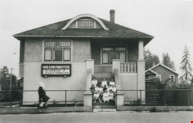
Forster family house and store
https://search.heritageburnaby.ca/link/archivedescription34972
- Repository
- City of Burnaby Archives
- Date
- [1924] (date of original), copied 1986
- Collection/Fonds
- Burnaby Historical Society fonds
- Description Level
- Item
- Physical Description
- 1 photograph : b&w ; 12.5 x 8.8 cm print
- Scope and Content
- Photograph of Wilson Forster's plumbing and electrical business and the Forster family home at 2849 McKay Avenue (later renumbered 6208 McKay Avenue).
- Repository
- City of Burnaby Archives
- Date
- [1924] (date of original), copied 1986
- Collection/Fonds
- Burnaby Historical Society fonds
- Subseries
- Forster family subseries
- Physical Description
- 1 photograph : b&w ; 12.5 x 8.8 cm print
- Description Level
- Item
- Record No.
- 168-007
- Access Restriction
- No restrictions
- Reproduction Restriction
- No known restrictions
- Accession Number
- BHS1986-17
- Scope and Content
- Photograph of Wilson Forster's plumbing and electrical business and the Forster family home at 2849 McKay Avenue (later renumbered 6208 McKay Avenue).
- Media Type
- Photograph
- Notes
- Title based on contents of photograph
- Geographic Access
- McKay Avenue
- Street Address
- 6208 McKay Avenue
- Historic Neighbourhood
- Central Park (Historic Neighbourhood)
- Planning Study Area
- Maywood Area
Images
![Forster family house and store, [1924] (date of original), copied 1986 thumbnail](/media/hpo/_Data/_Archives_Images/_Unrestricted/126/168-007.jpg)
![Forster family house and store, [1930] (date of original), copied 1986 thumbnail](/media/hpo/_Data/_Archives_Images/_Unrestricted/126/168-008.jpg?width=280)
Forster family house and store
https://search.heritageburnaby.ca/link/archivedescription34973
- Repository
- City of Burnaby Archives
- Date
- [1930] (date of original), copied 1986
- Collection/Fonds
- Burnaby Historical Society fonds
- Description Level
- Item
- Physical Description
- 1 photograph : b&w ; 8.8 x 12.5 cm print
- Scope and Content
- Photograph of Wilson Forster's plumbing and electrical business and the Forster family home at 2849 McKay Avenue after a snowfall (later renumbered 6208 McKay Avenue).
- Repository
- City of Burnaby Archives
- Date
- [1930] (date of original), copied 1986
- Collection/Fonds
- Burnaby Historical Society fonds
- Subseries
- Forster family subseries
- Physical Description
- 1 photograph : b&w ; 8.8 x 12.5 cm print
- Description Level
- Item
- Record No.
- 168-008
- Access Restriction
- No restrictions
- Reproduction Restriction
- No known restrictions
- Accession Number
- BHS1986-17
- Scope and Content
- Photograph of Wilson Forster's plumbing and electrical business and the Forster family home at 2849 McKay Avenue after a snowfall (later renumbered 6208 McKay Avenue).
- Media Type
- Photograph
- Notes
- Title based on contents of photograph
- Geographic Access
- McKay Avenue
- Street Address
- 6208 McKay Avenue
- Historic Neighbourhood
- Central Park (Historic Neighbourhood)
- Planning Study Area
- Maywood Area
Images
![Forster family house and store, [1930] (date of original), copied 1986 thumbnail](/media/hpo/_Data/_Archives_Images/_Unrestricted/126/168-008.jpg)
Forster House and Business
https://search.heritageburnaby.ca/link/archivedescription36789
- Repository
- City of Burnaby Archives
- Date
- 1924 (date of original), copied 1992
- Collection/Fonds
- Burnaby Historical Society fonds
- Description Level
- Item
- Physical Description
- 1 photograph : b&w ; 8.0 x 12.6 cm print
- Scope and Content
- Photograph of the Forster family home at 2849 McKay Avenue (old street number) also housing Wilson Forster's plumbing and electrical business. A group of girls are sitting on the front steps.
- Repository
- City of Burnaby Archives
- Date
- 1924 (date of original), copied 1992
- Collection/Fonds
- Burnaby Historical Society fonds
- Subseries
- Burnaby Centennial Anthology subseries
- Physical Description
- 1 photograph : b&w ; 8.0 x 12.6 cm print
- Description Level
- Item
- Record No.
- 315-246
- Access Restriction
- No restrictions
- Reproduction Restriction
- No known restrictions
- Accession Number
- BHS1994-04
- Scope and Content
- Photograph of the Forster family home at 2849 McKay Avenue (old street number) also housing Wilson Forster's plumbing and electrical business. A group of girls are sitting on the front steps.
- Media Type
- Photograph
- Notes
- Title based on contents of photograph
- Geographic Access
- McKay Avenue
- Street Address
- 6208 McKay Avenue
- Historic Neighbourhood
- Central Park (Historic Neighbourhood)
- Planning Study Area
- Maywood Area
Images

![Forster House and Business, [193-] (date of original), copied 1992 thumbnail](/media/hpo/_Data/_Archives_Images/_Unrestricted/315/315-247.jpg?width=280)
Forster House and Business
https://search.heritageburnaby.ca/link/archivedescription36790
- Repository
- City of Burnaby Archives
- Date
- [193-] (date of original), copied 1992
- Collection/Fonds
- Burnaby Historical Society fonds
- Description Level
- Item
- Physical Description
- 1 photograph : b&w ; 8.5 x 12.6 cm print
- Scope and Content
- Photograph of the Forster family home at 2849 McKay Avenue (old street number) with Wilson Forster's plumbing and electrical shop attached. Originally the business was located in the residence. A group of adults and children are on the front steps of the house.
- Repository
- City of Burnaby Archives
- Date
- [193-] (date of original), copied 1992
- Collection/Fonds
- Burnaby Historical Society fonds
- Subseries
- Burnaby Centennial Anthology subseries
- Physical Description
- 1 photograph : b&w ; 8.5 x 12.6 cm print
- Description Level
- Item
- Record No.
- 315-247
- Access Restriction
- No restrictions
- Reproduction Restriction
- No known restrictions
- Accession Number
- BHS1994-04
- Scope and Content
- Photograph of the Forster family home at 2849 McKay Avenue (old street number) with Wilson Forster's plumbing and electrical shop attached. Originally the business was located in the residence. A group of adults and children are on the front steps of the house.
- Media Type
- Photograph
- Notes
- Title based on contents of photograph
- Geographic Access
- McKay Avenue
- Street Address
- 6208 McKay Avenue
- Historic Neighbourhood
- Central Park (Historic Neighbourhood)
- Planning Study Area
- Maywood Area
Images
![Forster House and Business, [193-] (date of original), copied 1992 thumbnail](/media/hpo/_Data/_Archives_Images/_Unrestricted/315/315-247.jpg)

Yorston family home
https://search.heritageburnaby.ca/link/archivedescription35479
- Repository
- City of Burnaby Archives
- Date
- 1910 (date of original), copied 1986
- Collection/Fonds
- Burnaby Historical Society fonds
- Description Level
- Item
- Physical Description
- 1 photograph : b&w ; 12.7 x 17.8 cm print
- Scope and Content
- Photograph of the Yorston family home and Yorston real estate office at 4080 East Hastings (later 4050 Hastings Street), built in 1909. This was one of the first structures in Vancouver Heights on Hastings Street east of Boundary Road It was the home of Ernest A. Yorston, his wife Florence L. Yors…
- Repository
- City of Burnaby Archives
- Date
- 1910 (date of original), copied 1986
- Collection/Fonds
- Burnaby Historical Society fonds
- Subseries
- Pioneer Tales subseries
- Physical Description
- 1 photograph : b&w ; 12.7 x 17.8 cm print
- Description Level
- Item
- Record No.
- 204-337
- Access Restriction
- No restrictions
- Reproduction Restriction
- No known restrictions
- Accession Number
- BHS1988-03
- Scope and Content
- Photograph of the Yorston family home and Yorston real estate office at 4080 East Hastings (later 4050 Hastings Street), built in 1909. This was one of the first structures in Vancouver Heights on Hastings Street east of Boundary Road It was the home of Ernest A. Yorston, his wife Florence L. Yorston (nee Marston) and their children. The L.C. Tull furniture store can be seen in the background.
- Subjects
- Buildings - Residential - Houses
- Businesses - Real Estate Agencies
- Buildings - Commercial - Stores
- Names
- Yorston Real Estate
- Media Type
- Photograph
- Notes
- Title based on contents of photograph
- Geographic Access
- Hastings Street
- Street Address
- 4050 Hastings Street
- Historic Neighbourhood
- Vancouver Heights (Historic Neighbourhood)
- Planning Study Area
- Willingdon Heights Area
Images

Interview with Janet White May 10, 2005 - Track 7
https://search.heritageburnaby.ca/link/museumdescription4473
- Repository
- Burnaby Village Museum
- Date
- [1950-1959] (interview content), interviewed May 10, 2005
- Collection/Fonds
- Burnaby Village Museum fonds
- Description Level
- Item
- Physical Description
- 1 sound recording (mp3) (0:03:25 min)
- Scope and Content
- Track 7: This portion of the recording pertains to changes in Burnaby since Janet’s childhood, and her continuing connection to the community and its values. She also describes her family’s shopping routines from the 1940s and 1950s, which centred on the Super Value at Canada Way and Smith St., and…
- Repository
- Burnaby Village Museum
- Collection/Fonds
- Burnaby Village Museum fonds
- Series
- Museum Oral Histories series
- Subseries
- Growing Up in Burnaby subseries
- Description Level
- Item
- Physical Description
- 1 sound recording (mp3) (0:03:25 min)
- Material Details
- Interviewer: Tom Gooden Interviewee: Janet White Date of interview: May 10, 2005 Total Number of Tracks: 8 Total length of all Tracks: 0:31:34
- Scope and Content
- Track 7: This portion of the recording pertains to changes in Burnaby since Janet’s childhood, and her continuing connection to the community and its values. She also describes her family’s shopping routines from the 1940s and 1950s, which centred on the Super Value at Canada Way and Smith St., and the Hudson’s Bay store downtown. When Woodward’s and Sears opened, the family also shopped there occasionally.
- History
- Recording of an interview with Janet White recording by Tom Gooden on May 10 2005. This recording was completed for an exhibit, Growing Up in Burnaby, for the Burnaby Village Museum. Major themes discussed are growing up in Burnaby in the 1950s.
- Creator
- Burnaby Village Museum
- Names
- Gooden, Tom
- White, Janet
- Geographic Access
- Canada Way
- Smith Avenue
- Accession Code
- BV017.45.1
- Access Restriction
- No restrictions
- Reproduction Restriction
- May be restricted by third party rights
- Date
- [1950-1959] (interview content), interviewed May 10, 2005
- Media Type
- Sound Recording
Audio Tracks
Interview with Janet White May 10, 2005 - Track 7, [1950-1959] (interview content), interviewed May 10, 2005
Interview with Janet White May 10, 2005 - Track 7, [1950-1959] (interview content), interviewed May 10, 2005
https://search.heritageburnaby.ca/media/hpo/_Data/_BVM_Sound_Recordings/Oral_Histories/2017_0045_0001_007.mp3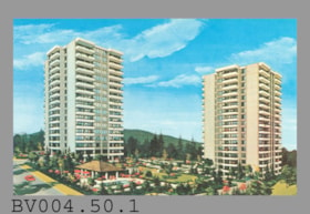
postcard
https://search.heritageburnaby.ca/link/museumartifact47195
- Repository
- Burnaby Village Museum
- Accession Code
- BV004.50.1
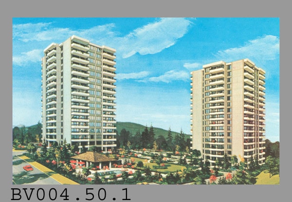
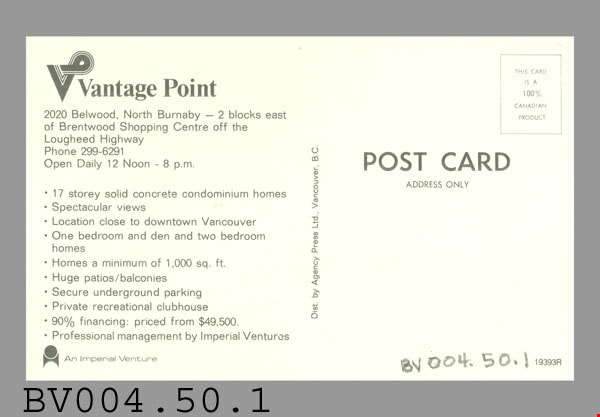
- Description
- Postcard: advertisement for "Vantage Point," a two high-rise development; coloured rendering; horizontal; glossy; shows two multi-storey buildings, landscaping, smaller building by pool, blue sky with clouds; on reverse in black "Vantage Point", logo, "2020 Belwood, North Burnaby -- 2 blocks east of Brentwood Shopping Centre off the Lougheed Highway" "Phone 299-6291" "Open Daily 12 Noon - 8 p.m."; 10 bullet points follow, about the property; at bottom, "An Imperial Venture", logo; up centre of card, "Dist. by Agency Press Ltd., Vancouver, B.C."; at right, "POST CARD" "ADDRESS ONLY"; outling of rectangle at upper right, "THIS CARD IS A 100% CANADIAN PRODUCT"; at lower right, "19393R"; slight wear on corners; c.1970s?; unused
- Classification
- Written Communication T&E - - Writing Media
- Object Term
- Postcard
- Marks/Labels
- Vantage Point / 2020 Belwood, North Burnaby / Brentwood Shopping Centre / Lougheed Highway
- Country Made
- Canada
- Province Made
- British Columbia
- Site/City Made
- Vancouver
- Title
- Vantage Point 19393R
- Subjects
- Documentary Artifacts
- Documentary Artifacts - Postcards
- Buildings
- Buildings - Residential
- Buildings - Residential - Apartments
Images
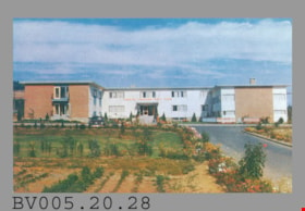
postcard
https://search.heritageburnaby.ca/link/museumartifact48385
- Repository
- Burnaby Village Museum
- Accession Code
- BV005.20.28
- Description
- Postcard: colour photo, glossy; horizontal; shows two-storey building, brick and plaster; red "SWEDISH CANADIAN REST HOME" over entrance; drive visible, lawn and shrubs in foreground, vegetable garden?; on reverse in black "SWEDISH CANADIAN REST HOME" “1800 Duthie Avenue Burnaby, B.C.," "Dedicated to Man and Woman who in twilight of Life, seek comfort, rest and contentment."; line down centre, at bottom "Tri Color" "Made in Canada, Exclusively by Frank T. Coan Ltd. Vancouver, B.C."; at right, "POST CARD" "ADDRESS ONLY"; outline of rectangle at upper right; unused
- Classification
- Written Communication T&E - - Writing Media
- Object Term
- Postcard
- Marks/Labels
- Swedish Canadian Rest Home / 1800 Duthie Avenue Burnaby, B.C. / Dedicated to Man and Woman.. / Tri Colour / Made in Canada, exclusively by Frank T. Coan Ltd. Vancouver, B.C.
- Maker
- Frank T. Coan Limited
- Country Made
- Canada
- Province Made
- British Columbia
- Site/City Made
- Vancouver
- Title
- Swedish Canadian Rest Home
- Subjects
- Documentary Artifacts
- Documentary Artifacts - Postcards
- Documentary Artifacts - Photographs
- Buildings
- Buildings - Residential
- Buildings - Residential - Apartments
Images
