More like 'Driving over a log bridge'
Narrow Results By
Subject
- Academic Disciplines 1
- Accidents 10
- Accidents - Automobile Accidents 11
- Accidents - Train Accidents 9
- Adornment 1
- Adornment - Lapel Pins 1
- Advertising Medium 16
- Advertising Medium - Signs and Signboards 66
- Aerial Photographs 36
- Agricultural Tools and Equipment 6
- Agricultural Tools and Equipment - Gardening Equipment 6
- Agricultural Tools and Equipment - Plows 9
![Old Brunette Dam, [1925] (date of original), copied 1986 thumbnail](/media/hpo/_Data/_Archives_Images/_Unrestricted/204/204-324.jpg?width=280)
Old Brunette Dam
https://search.heritageburnaby.ca/link/archivedescription35466
- Repository
- City of Burnaby Archives
- Date
- [1925] (date of original), copied 1986
- Collection/Fonds
- Burnaby Historical Society fonds
- Description Level
- Item
- Physical Description
- 1 photograph : b&w ; 12.7 x 17.8 cm print
- Scope and Content
- Photograph of the old Brunette dam before 1931. Shown on the left, the spillway allowed spawning salmon to wriggle over into spawning grounds in Eagle Creek and Still Creek.
- Repository
- City of Burnaby Archives
- Date
- [1925] (date of original), copied 1986
- Collection/Fonds
- Burnaby Historical Society fonds
- Subseries
- Pioneer Tales subseries
- Physical Description
- 1 photograph : b&w ; 12.7 x 17.8 cm print
- Description Level
- Item
- Record No.
- 204-324
- Access Restriction
- No restrictions
- Reproduction Restriction
- No known restrictions
- Accession Number
- BHS1988-03
- Scope and Content
- Photograph of the old Brunette dam before 1931. Shown on the left, the spillway allowed spawning salmon to wriggle over into spawning grounds in Eagle Creek and Still Creek.
- Media Type
- Photograph
- Notes
- Title based on contents of photograph
- Historic Neighbourhood
- Burquitlam (Historic Neighbourhood)
- Planning Study Area
- Burnaby Lake Area
Images
![Old Brunette Dam, [1925] (date of original), copied 1986 thumbnail](/media/hpo/_Data/_Archives_Images/_Unrestricted/204/204-324.jpg)
![Old Brunette River Dam, [1920] thumbnail](/media/hpo/_Data/_Archives_Images/_Unrestricted/205/232-002.jpg?width=280)
Old Brunette River Dam
https://search.heritageburnaby.ca/link/archivedescription36205
- Repository
- City of Burnaby Archives
- Date
- [1920]
- Collection/Fonds
- Burnaby Historical Society fonds
- Description Level
- Item
- Physical Description
- 1 photograph : b&w ; 8.5 x 12.5 cm print
- Scope and Content
- Photograph of a group of six men and their five dogs at the Old Brunette River Dam. The men are in suits and most are wearing bowler hats. Their dogs look to be English Foxhounds and Poodles.
- Repository
- City of Burnaby Archives
- Date
- [1920]
- Collection/Fonds
- Burnaby Historical Society fonds
- Subseries
- Love family subseries
- Physical Description
- 1 photograph : b&w ; 8.5 x 12.5 cm print
- Description Level
- Item
- Record No.
- 232-002
- Access Restriction
- No restrictions
- Reproduction Restriction
- No known restrictions
- Accession Number
- BHS1989-24
- Scope and Content
- Photograph of a group of six men and their five dogs at the Old Brunette River Dam. The men are in suits and most are wearing bowler hats. Their dogs look to be English Foxhounds and Poodles.
- Media Type
- Photograph
- Notes
- Title based on contents of photograph
- 1 b&w copy negative accompanying
- Geographic Access
- Brunette River
- Historic Neighbourhood
- Burquitlam (Historic Neighbourhood)
- Planning Study Area
- Burnaby Lake Area
Images
![Old Brunette River Dam, [1920] thumbnail](/media/hpo/_Data/_Archives_Images/_Unrestricted/205/232-002.jpg)
![Water flowing from Stave Lake Dam, [c. 1915] thumbnail](/media/hpo/_Data/_BVM_Images/2022/2022_0032_0019_001.jpg?width=280)
Water flowing from Stave Lake Dam
https://search.heritageburnaby.ca/link/museumdescription19302
- Repository
- Burnaby Village Museum
- Date
- [c. 1915]
- Collection/Fonds
- Esther Love Stanley fonds
- Description Level
- Item
- Physical Description
- 1 photograph : b&w ; 10.5 x 8 cm
- Scope and Content
- Photograph of water flowing from Stave Lake Dam into the Stave River in Mission, British Columbia. Shoreline with large rocks in the foreground and barren trees on the hillsides bordering the river.
- Repository
- Burnaby Village Museum
- Collection/Fonds
- Esther Love Stanley fonds
- Description Level
- Item
- Physical Description
- 1 photograph : b&w ; 10.5 x 8 cm
- Scope and Content
- Photograph of water flowing from Stave Lake Dam into the Stave River in Mission, British Columbia. Shoreline with large rocks in the foreground and barren trees on the hillsides bordering the river.
- Accession Code
- BV022.32.19
- Access Restriction
- No restrictions
- Reproduction Restriction
- No known restrictions
- Date
- [c. 1915]
- Media Type
- Photograph
- Scan Resolution
- 600
- Scan Date
- 2023-04-04
- Notes
- Title based on contents of photograph
- Photograph is part of Esther Love Stanley photograph album 1 (BV022.32.1)
Images
![Water flowing from Stave Lake Dam, [c. 1915] thumbnail](/media/hpo/_Data/_BVM_Images/2022/2022_0032_0019_001.jpg)

Alexandra Bridge in British Columbia
https://search.heritageburnaby.ca/link/archivedescription65748
- Repository
- City of Burnaby Archives
- Date
- 1936
- Collection/Fonds
- Burnaby Historical Society fonds
- Description Level
- Item
- Physical Description
- 1 photograph : b&w hand-tinted into col. ; 17.5 x 24.5 cm [sight] matted in frame 24.5 x 32 cm
- Scope and Content
- Photograph of the Alexandra Bridge in British Columbia. The Alexander Bridge crosses the Fraser Canyon, along the Cariboo Highway, two kilometres north of Spuzzum.
- Repository
- City of Burnaby Archives
- Date
- 1936
- Collection/Fonds
- Burnaby Historical Society fonds
- Subseries
- Ettinger family subseries
- Physical Description
- 1 photograph : b&w hand-tinted into col. ; 17.5 x 24.5 cm [sight] matted in frame 24.5 x 32 cm
- Description Level
- Item
- Record No.
- 428-007
- Access Restriction
- No restrictions
- Reproduction Restriction
- No known restrictions
- Accession Number
- BHS2002-03
- Scope and Content
- Photograph of the Alexandra Bridge in British Columbia. The Alexander Bridge crosses the Fraser Canyon, along the Cariboo Highway, two kilometres north of Spuzzum.
- Media Type
- Photograph
- Photographer
- Edmonds Studio
- Notes
- Title based on contents of photograph
- Note on verso of frame reads: "Spuzzum Bridge / Fraser Canyon"
- Note on recto of matte reads: "Edmonds Studio 1936"
Images


Alexandra Bridge in British Columbia
https://search.heritageburnaby.ca/link/archivedescription85920
- Repository
- City of Burnaby Archives
- Date
- 1933
- Collection/Fonds
- Burnaby Historical Society fonds
- Description Level
- Item
- Physical Description
- 1 photograph : sepia ; 5.5 x 10 cm
- Scope and Content
- Photograph of the Alexandra Bridge in British Columbia. The Alexander Bridge crosses the Fraser Canyon, along the Cariboo Highway, two kilometres north of Spuzzum.
- Repository
- City of Burnaby Archives
- Date
- 1933
- Collection/Fonds
- Burnaby Historical Society fonds
- Subseries
- Ettinger family subseries
- Physical Description
- 1 photograph : sepia ; 5.5 x 10 cm
- Description Level
- Item
- Record No.
- 428-008
- Access Restriction
- No restrictions
- Reproduction Restriction
- No known restrictions
- Accession Number
- BHS2002-03
- Scope and Content
- Photograph of the Alexandra Bridge in British Columbia. The Alexander Bridge crosses the Fraser Canyon, along the Cariboo Highway, two kilometres north of Spuzzum.
- Media Type
- Photograph
- Notes
- Title based on contents of photograph
- Note on verso of photograph reads: "Alexander [sic] Bridge / 1933"
Images


Barnet Marine Park
https://search.heritageburnaby.ca/link/archivedescription91581
- Repository
- City of Burnaby Archives
- Date
- August 9, 1996
- Collection/Fonds
- Doreen Lawson fonds
- Description Level
- File
- Physical Description
- 18 photographs : col. slides ; 35 mm
- Scope and Content
- File consists of photographs of Barnet Marine Park, including Barnet Beach pilings, overpass and people preparing kayaks on the shore.
- Repository
- City of Burnaby Archives
- Date
- August 9, 1996
- Collection/Fonds
- Doreen Lawson fonds
- Physical Description
- 18 photographs : col. slides ; 35 mm
- Description Level
- File
- Record No.
- 605-014
- Access Restriction
- No restrictions
- Reproduction Restriction
- No restrictions
- Accession Number
- 2003-30
- Scope and Content
- File consists of photographs of Barnet Marine Park, including Barnet Beach pilings, overpass and people preparing kayaks on the shore.
- Names
- Lawson, Doreen A.
- Media Type
- Photograph
- Photographer
- Lawson, Doreen A.
- Notes
- Title based on contents of photographs
- Note in black in on recto of slide frames of photographs 605-014-1 : 605-014-7, 605-014-9 : 605-014-11, and 605-014-13 reads: "Barnet Beach Pilings"
- Note in black ink on recto of slide frames of photographs 605-014-8 and 605-014-12 reads: "Barnet Beach Kayaks"
- Note in black ink on recto of slide frames of photographs 605-014-14 : 605-014-18 reads: "Barnet Beach Overpass"
- Geographic Access
- Barnet Marine Park
- Historic Neighbourhood
- Barnet (Historic Neighbourhood)
- Planning Study Area
- Burnaby Mountain Area
Images

![Bridge, [191-] thumbnail](/media/hpo/_Data/_BVM_Images/2022/2022_0032_0173_001.jpg?width=280)
Bridge
https://search.heritageburnaby.ca/link/museumdescription19751
- Repository
- Burnaby Village Museum
- Date
- [191-]
- Collection/Fonds
- Esther Love Stanley fonds
- Description Level
- Item
- Physical Description
- 1 photograph : b&w ; 11 x 8 cm
- Scope and Content
- Photograph of a bridge over body of water.
- Repository
- Burnaby Village Museum
- Collection/Fonds
- Esther Love Stanley fonds
- Description Level
- Item
- Physical Description
- 1 photograph : b&w ; 11 x 8 cm
- Scope and Content
- Photograph of a bridge over body of water.
- Accession Code
- BV022.32.173
- Access Restriction
- No restrictions
- Reproduction Restriction
- No known restrictions
- Date
- [191-]
- Media Type
- Photograph
- Scan Resolution
- 600
- Scan Date
- 2023-04-04
- Notes
- Title based on contents of photograph
- Photograph is part of Esther Love Stanley photograph album 1 (BV022.32.1)
Images
![Bridge, [191-] thumbnail](/media/hpo/_Data/_BVM_Images/2022/2022_0032_0173_001.jpg)
![Bridge and trail in Robert Burnaby Park, [between 1933 and 1947] (date of original), copied 2014 thumbnail](/media/hpo/_Data/_Archives_Images/_Unrestricted/580/581-012.jpg?width=280)
Bridge and trail in Robert Burnaby Park
https://search.heritageburnaby.ca/link/archivedescription88406
- Repository
- City of Burnaby Archives
- Date
- [between 1933 and 1947] (date of original), copied 2014
- Collection/Fonds
- James Massey family fonds
- Description Level
- Item
- Physical Description
- 1 photograph (tiff) : sepia ; 600 dpi
- Scope and Content
- Photograph of a trail in Robert Burnaby Park with a bridge in the middle ground and stairs leading to higher ground. The bridge and trail are surrounded by lush foliage and trees.
- Repository
- City of Burnaby Archives
- Date
- [between 1933 and 1947] (date of original), copied 2014
- Collection/Fonds
- James Massey family fonds
- Physical Description
- 1 photograph (tiff) : sepia ; 600 dpi
- Description Level
- Item
- Record No.
- 581-012
- Access Restriction
- No restrictions
- Reproduction Restriction
- No known restrictions
- Accession Number
- 2014-34
- Scope and Content
- Photograph of a trail in Robert Burnaby Park with a bridge in the middle ground and stairs leading to higher ground. The bridge and trail are surrounded by lush foliage and trees.
- Media Type
- Photograph
- Notes
- Title based on contents of photograph
- Historic Neighbourhood
- East Burnaby (Historic Neighbourhood)
- Planning Study Area
- Lakeview-Mayfield Area
Images
![Bridge and trail in Robert Burnaby Park, [between 1933 and 1947] (date of original), copied 2014 thumbnail](/media/hpo/_Data/_Archives_Images/_Unrestricted/580/581-012.jpg)
![Bridge over river, [c. 1910] thumbnail](/media/hpo/_Data/_BVM_Images/2022/2022_0032_0037_001.jpg?width=280)
Bridge over river
https://search.heritageburnaby.ca/link/museumdescription19320
- Repository
- Burnaby Village Museum
- Date
- [c. 1910]
- Collection/Fonds
- Esther Love Stanley fonds
- Description Level
- Item
- Physical Description
- 1 photograph : b&w ; 7.5 x 10.5 cm
- Scope and Content
- Photograph of a wooden bridge over a narrow river. The banks of the river can be seen on either side of the bridge. A pile of lumber is visible on the riverbank next to the bridge.
- Repository
- Burnaby Village Museum
- Collection/Fonds
- Esther Love Stanley fonds
- Description Level
- Item
- Physical Description
- 1 photograph : b&w ; 7.5 x 10.5 cm
- Scope and Content
- Photograph of a wooden bridge over a narrow river. The banks of the river can be seen on either side of the bridge. A pile of lumber is visible on the riverbank next to the bridge.
- Accession Code
- BV022.32.37
- Access Restriction
- No restrictions
- Reproduction Restriction
- No known restrictions
- Date
- [c. 1910]
- Media Type
- Photograph
- Scan Resolution
- 600
- Scan Date
- 2023-04-04
- Notes
- Title based on contents of photograph
- Photograph is part of Esther Love Stanley photograph album 1 (BV022.32.1)
Images
![Bridge over river, [c. 1910] thumbnail](/media/hpo/_Data/_BVM_Images/2022/2022_0032_0037_001.jpg)
![Bridge over rushing creek, [194-] thumbnail](/media/hpo/_Data/_BVM_Images/2022/2022_0032_0490_001.jpg?width=280)
Bridge over rushing creek
https://search.heritageburnaby.ca/link/museumdescription20068
- Repository
- Burnaby Village Museum
- Date
- [194-]
- Collection/Fonds
- Esther Love Stanley fonds
- Description Level
- Item
- Physical Description
- 1 photograph : b&w ; 6.5 x 6.5 cm
- Scope and Content
- Photograph of bridge over rushing rocky creek.
- Repository
- Burnaby Village Museum
- Collection/Fonds
- Esther Love Stanley fonds
- Description Level
- Item
- Physical Description
- 1 photograph : b&w ; 6.5 x 6.5 cm
- Scope and Content
- Photograph of bridge over rushing rocky creek.
- Accession Code
- BV022.32.490
- Access Restriction
- No restrictions
- Reproduction Restriction
- No known restrictions
- Date
- [194-]
- Media Type
- Photograph
- Scan Resolution
- 600
- Scan Date
- 2023-07-18
- Notes
- Title based on contents of photograph
- Photograph is part of Esther Love Stanley photograph album 2 (BV032.22.431)
Images
![Bridge over rushing creek, [194-] thumbnail](/media/hpo/_Data/_BVM_Images/2022/2022_0032_0490_001.jpg)
![Bridge over South Creek on Burnaby Mountain, [1995] thumbnail](/media/Hpo/_Data/_Archives_Images/_Unrestricted/629/629-009.jpg?width=280)
Bridge over South Creek on Burnaby Mountain
https://search.heritageburnaby.ca/link/archivedescription97808
- Repository
- City of Burnaby Archives
- Date
- [1995]
- Collection/Fonds
- Burnaby Mountain Preservation Society fonds
- Description Level
- Item
- Physical Description
- 1 photograph : col. slide ; 35 mm
- Scope and Content
- Photograph of a creek bridge.
- Repository
- City of Burnaby Archives
- Date
- [1995]
- Collection/Fonds
- Burnaby Mountain Preservation Society fonds
- Physical Description
- 1 photograph : col. slide ; 35 mm
- Description Level
- Item
- Record No.
- 629-009
- Access Restriction
- No restrictions
- Reproduction Restriction
- Reproduce for fair dealing purposes only
- Accession Number
- 2006-13
- Scope and Content
- Photograph of a creek bridge.
- Media Type
- Photograph
- Notes
- Handwritten note on slide reads: "Bridge Over S. Creek."
- Geographic Access
- Burnaby Mountain Conservation Area
- Planning Study Area
- Burnaby Mountain Area
Images
![Bridge over South Creek on Burnaby Mountain, [1995] thumbnail](/media/Hpo/_Data/_Archives_Images/_Unrestricted/629/629-009.jpg)
![Brunette Bridge, looking south, [1914] thumbnail](/media/hpo/_Data/_BVM_Images/1971/197200110021.jpg?width=280)
Brunette Bridge, looking south
https://search.heritageburnaby.ca/link/museumdescription3107
- Repository
- Burnaby Village Museum
- Date
- [1914]
- Collection/Fonds
- Burnaby Village Museum Photograph collection
- Description Level
- Item
- Physical Description
- 1 photograph : b&w glass negative ; 16.4 x 21.3 cm
- Scope and Content
- Photograph of North Road and the Brunette Bridge, looking south into New Westminster from Burnaby. By the northern end of the bridge, there is a pit being dug with shovels. A few houses can be seen on the southwest side of the bridge. The house furthest away is identified as the William Holmes hou…
- Repository
- Burnaby Village Museum
- Collection/Fonds
- Burnaby Village Museum Photograph collection
- Description Level
- Item
- Physical Description
- 1 photograph : b&w glass negative ; 16.4 x 21.3 cm
- Scope and Content
- Photograph of North Road and the Brunette Bridge, looking south into New Westminster from Burnaby. By the northern end of the bridge, there is a pit being dug with shovels. A few houses can be seen on the southwest side of the bridge. The house furthest away is identified as the William Holmes house (Burnaby's first settler to pre-empt property in Burnaby). All of the land on the right side of the road was purchased by William H. Holmes in 1860 (District Lot 1, Group 1, New Westminster District). A car is parked on the side of the road south of the bridge. The shorter ash tree south of the bridge is identified as the famous "Holmes Ash Tree" (also known as the "Moody tree").
- Accession Code
- HV972.11.21
- Access Restriction
- No restrictions
- Reproduction Restriction
- No known restrictions
- Date
- [1914]
- Media Type
- Photograph
- Planning Study Area
- Cariboo-Armstrong Area
- Related Material
- See also: William Holmes fonds
- Scan Resolution
- 300
- Scan Date
- 14/8/2006
- Scale
- 100
- Notes
- Title based on contents of photograph
- 1 b&w contact print accompanying negative
- Inscribed on the negative, lower left of the print: "Brunette Bridge / Looking South."
Images
![Brunette Bridge, looking south, [1914] thumbnail](/media/hpo/_Data/_BVM_Images/1971/197200110021.jpg)
![Burrard Inlet, [1930] thumbnail](/media/hpo/_Data/_Archives_Images/_Unrestricted/371/443-013.jpg?width=280)
Burrard Inlet
https://search.heritageburnaby.ca/link/archivedescription38446
- Repository
- City of Burnaby Archives
- Date
- [1930]
- Collection/Fonds
- Burnaby Historical Society fonds
- Description Level
- Item
- Physical Description
- 1 photograph : b&w ; 6.4 x 9 cm
- Scope and Content
- Photograph looking west from 410 North Hythe Avenue towards Burrard Inlet. The Second Narrows Bridge can be seen faintly in the background.
- Repository
- City of Burnaby Archives
- Date
- [1930]
- Collection/Fonds
- Burnaby Historical Society fonds
- Subseries
- Photographs subseries
- Physical Description
- 1 photograph : b&w ; 6.4 x 9 cm
- Description Level
- Item
- Record No.
- 443-013
- Access Restriction
- No restrictions
- Reproduction Restriction
- No known restrictions
- Accession Number
- BHS2002-13
- Scope and Content
- Photograph looking west from 410 North Hythe Avenue towards Burrard Inlet. The Second Narrows Bridge can be seen faintly in the background.
- Media Type
- Photograph
- Notes
- Title based on contents of photograph
- Geographic Access
- Hythe Avenue North
- Street Address
- 410 Hythe Avenue North
- Historic Neighbourhood
- Capitol Hill (Historic Neighbourhood)
- Planning Study Area
- Capitol Hill Area
Images
![Burrard Inlet, [1930] thumbnail](/media/hpo/_Data/_Archives_Images/_Unrestricted/371/443-013.jpg)
![Burrard Inlet, [1930] thumbnail](/media/hpo/_Data/_Archives_Images/_Unrestricted/371/443-014.jpg?width=280)
Burrard Inlet
https://search.heritageburnaby.ca/link/archivedescription38447
- Repository
- City of Burnaby Archives
- Date
- [1930]
- Collection/Fonds
- Burnaby Historical Society fonds
- Description Level
- Item
- Physical Description
- 1 photograph : b&w ; 6.3 x 9 cm
- Scope and Content
- Photograph taken from 410 North Hythe Avenue looking towards the Burrard Inlet. The Second Narrows Bridge can be seen faintly in the background.
- Repository
- City of Burnaby Archives
- Date
- [1930]
- Collection/Fonds
- Burnaby Historical Society fonds
- Subseries
- Photographs subseries
- Physical Description
- 1 photograph : b&w ; 6.3 x 9 cm
- Description Level
- Item
- Record No.
- 443-014
- Access Restriction
- No restrictions
- Reproduction Restriction
- No known restrictions
- Accession Number
- BHS2002-13
- Scope and Content
- Photograph taken from 410 North Hythe Avenue looking towards the Burrard Inlet. The Second Narrows Bridge can be seen faintly in the background.
- Media Type
- Photograph
- Notes
- Title based on contents of photograph.
- Geographic Access
- Hythe Avenue North
- Street Address
- 410 Hythe Avenue North
- Historic Neighbourhood
- Capitol Hill (Historic Neighbourhood)
- Planning Study Area
- Capitol Hill Area
Images
![Burrard Inlet, [1930] thumbnail](/media/hpo/_Data/_Archives_Images/_Unrestricted/371/443-014.jpg)
![E.B. Wetenhall and Kitty Hill, [1902] thumbnail](/media/hpo/_Data/_Archives_Images/_Unrestricted/477/477-100.jpg?width=280)
E.B. Wetenhall and Kitty Hill
https://search.heritageburnaby.ca/link/archivedescription38781
- Repository
- City of Burnaby Archives
- Date
- [1902]
- Collection/Fonds
- Peers Family and Hill Family fonds
- Description Level
- Item
- Physical Description
- 1 photograph : b&w ; 6 x 8 cm on page 11.5 x 14 cm (pasted in album)
- Scope and Content
- Photograph of E.B. Wetenhall leading a horse to water. Kitty Hill is the foreground and a wooden trestle bridge spans Deer Lake Brook in the background.
- Repository
- City of Burnaby Archives
- Date
- [1902]
- Collection/Fonds
- Peers Family and Hill Family fonds
- Physical Description
- 1 photograph : b&w ; 6 x 8 cm on page 11.5 x 14 cm (pasted in album)
- Description Level
- Item
- Record No.
- 477-100
- Access Restriction
- No restrictions
- Reproduction Restriction
- No known restrictions
- Accession Number
- 2007-12
- Scope and Content
- Photograph of E.B. Wetenhall leading a horse to water. Kitty Hill is the foreground and a wooden trestle bridge spans Deer Lake Brook in the background.
- Media Type
- Photograph
- Notes
- Title based on contents of photograph
- Geographic Access
- Deer Lake Brook
- Deer Lake Avenue
- Street Address
- 6501 Deer Lake Avenue
- Historic Neighbourhood
- Burnaby Lake (Historic Neighbourhood)
- Planning Study Area
- Morley-Buckingham Area
Images
![E.B. Wetenhall and Kitty Hill, [1902] thumbnail](/media/hpo/_Data/_Archives_Images/_Unrestricted/477/477-100.jpg)

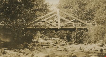
Emory Creek Bridge
https://search.heritageburnaby.ca/link/archivedescription34490
- Repository
- City of Burnaby Archives
- Date
- 1925
- Collection/Fonds
- Burnaby Historical Society fonds
- Description Level
- Item
- Physical Description
- 1 photograph : b&w ; 7.2 x 13.3 cm on page 17.5 x 26.4 cm
- Scope and Content
- Photograph of a wooden bridge spanning Emory Creek. Three people can be seen standing on the bridge and they are identified as R.H.B., E.D., and A.S.D. This photograph appears to have been taken by Arthur Peers, who travelled through the Fraser River Valley and worked on the construction of the T…
- Repository
- City of Burnaby Archives
- Date
- 1925
- Collection/Fonds
- Burnaby Historical Society fonds
- Subseries
- Peers family subseries
- Physical Description
- 1 photograph : b&w ; 7.2 x 13.3 cm on page 17.5 x 26.4 cm
- Description Level
- Item
- Record No.
- 020-197
- Access Restriction
- No restrictions
- Reproduction Restriction
- No restrictions
- Accession Number
- BHS2007-04
- Scope and Content
- Photograph of a wooden bridge spanning Emory Creek. Three people can be seen standing on the bridge and they are identified as R.H.B., E.D., and A.S.D. This photograph appears to have been taken by Arthur Peers, who travelled through the Fraser River Valley and worked on the construction of the Trans-Provincial Highway during the later 1920s.
- Media Type
- Photograph
- Photographer
- Peers, Arthur Francis "Mike"
- Notes
- Title based on caption accompanying photograph
Images
![First Narrows Bridge, [1938] thumbnail](/media/hpo/_Data/_BVM_Images/1996/1996_0006_0233_001.jpg?width=280)
First Narrows Bridge
https://search.heritageburnaby.ca/link/museumdescription19526
- Repository
- Burnaby Village Museum
- Date
- [1938]
- Collection/Fonds
- Hawkshaw family fonds
- Description Level
- Item
- Physical Description
- 1 photograph : sepia ; 6.5 x 9 cm
- Scope and Content
- Photograph of the First Narrows Bridge (Lions Gate Bridge). Photograph is taken from the shore looking west towards the suspension bridge which spans the first narrows of Burrard Inet connecting the City of Vancouver to the North Shore.
- Repository
- Burnaby Village Museum
- Collection/Fonds
- Hawkshaw family fonds
- Description Level
- Item
- Physical Description
- 1 photograph : sepia ; 6.5 x 9 cm
- Scope and Content
- Photograph of the First Narrows Bridge (Lions Gate Bridge). Photograph is taken from the shore looking west towards the suspension bridge which spans the first narrows of Burrard Inet connecting the City of Vancouver to the North Shore.
- Accession Code
- BV996.6.233
- Access Restriction
- No restrictions
- Reproduction Restriction
- No known restrictions
- Date
- [1938]
- Media Type
- Photograph
- Scan Resolution
- 600
- Scan Date
- 2023-02-16
- Notes
- Title based on contents of photograph
- Photograph is part of photograph album BV996.6.1
Images
![First Narrows Bridge, [1938] thumbnail](/media/hpo/_Data/_BVM_Images/1996/1996_0006_0233_001.jpg)
![First Narrows Bridge, [1938] thumbnail](/media/hpo/_Data/_BVM_Images/1996/1996_0006_0234_001.jpg?width=280)
First Narrows Bridge
https://search.heritageburnaby.ca/link/museumdescription19527
- Repository
- Burnaby Village Museum
- Date
- [1938]
- Collection/Fonds
- Hawkshaw family fonds
- Description Level
- Item
- Physical Description
- 1 photograph : sepia ; 6.5 x 9 cm
- Scope and Content
- Photograph of the First Narrows Bridge (Lions Gate Bridge). Photograph is taken from the shore looking west towards the suspension bridge which spans the first narrows of Burrard Inet connecting the City of Vancouver to the North Shore.
- Repository
- Burnaby Village Museum
- Collection/Fonds
- Hawkshaw family fonds
- Description Level
- Item
- Physical Description
- 1 photograph : sepia ; 6.5 x 9 cm
- Scope and Content
- Photograph of the First Narrows Bridge (Lions Gate Bridge). Photograph is taken from the shore looking west towards the suspension bridge which spans the first narrows of Burrard Inet connecting the City of Vancouver to the North Shore.
- Accession Code
- BV996.6.234
- Access Restriction
- No restrictions
- Reproduction Restriction
- No known restrictions
- Date
- [1938]
- Media Type
- Photograph
- Scan Resolution
- 600
- Scan Date
- 2023-02-16
- Notes
- Title based on contents of photograph
- Photograph is part of photograph album BV996.6.1
Images
![First Narrows Bridge, [1938] thumbnail](/media/hpo/_Data/_BVM_Images/1996/1996_0006_0234_001.jpg)
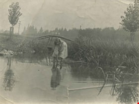
Kitty Hill wading in Deer Lake
https://search.heritageburnaby.ca/link/archivedescription39424
- Repository
- City of Burnaby Archives
- Date
- 1910
- Collection/Fonds
- Peers Family and Hill Family fonds
- Description Level
- Item
- Physical Description
- 1 photograph : b&w ; 7.2 x 10 cm
- Scope and Content
- Photograph of Kitty Hill wading in a small shallow creek. She has her feet submerged, and is dipping her hand in the water while looking up at the photographer. Just behind her is a small log bridge built over the creek, behind which can be seen a street lined with power poles, and a house in the …
- Repository
- City of Burnaby Archives
- Date
- 1910
- Collection/Fonds
- Peers Family and Hill Family fonds
- Physical Description
- 1 photograph : b&w ; 7.2 x 10 cm
- Description Level
- Item
- Record No.
- 477-743
- Access Restriction
- No restrictions
- Reproduction Restriction
- No known restrictions
- Accession Number
- 2007-12
- Scope and Content
- Photograph of Kitty Hill wading in a small shallow creek. She has her feet submerged, and is dipping her hand in the water while looking up at the photographer. Just behind her is a small log bridge built over the creek, behind which can be seen a street lined with power poles, and a house in the far distance, identified as "Broadview". An annotation on the back of the photo reads, "Kitty Hill 1910."
- Media Type
- Photograph
- Notes
- Title based on caption accompanying photograph
- Geographic Access
- Buckingham Avenue
- Deer Lake
- Street Address
- 5730 Buckingham Avenue
- Historic Neighbourhood
- Burnaby Lake (Historic Neighbourhood)
- Planning Study Area
- Morley-Buckingham Area
Images

![Lions Gate Bridge, [1938] thumbnail](/media/hpo/_Data/_Archives_Images/_Unrestricted/371/443-009.jpg?width=280)
Lions Gate Bridge
https://search.heritageburnaby.ca/link/archivedescription38442
- Repository
- City of Burnaby Archives
- Date
- [1938]
- Collection/Fonds
- Burnaby Historical Society fonds
- Description Level
- Item
- Physical Description
- 1 photograph : b&w ; 6.2 x 8.2 cm
- Scope and Content
- Photograph of the Lions Gate Bridge over the Burrard Inlet.
- Repository
- City of Burnaby Archives
- Date
- [1938]
- Collection/Fonds
- Burnaby Historical Society fonds
- Subseries
- Photographs subseries
- Physical Description
- 1 photograph : b&w ; 6.2 x 8.2 cm
- Description Level
- Item
- Record No.
- 443-009
- Access Restriction
- No restrictions
- Reproduction Restriction
- No known restrictions
- Accession Number
- BHS2002-13
- Scope and Content
- Photograph of the Lions Gate Bridge over the Burrard Inlet.
- Media Type
- Photograph
- Notes
- Title based on contents of photograph.
Images
![Lions Gate Bridge, [1938] thumbnail](/media/hpo/_Data/_Archives_Images/_Unrestricted/371/443-009.jpg)