More like 'Government Road'
Narrow Results By
Subject
- Accidents 2
- Aerial Photographs 1
- Agricultural Tools and Equipment - Gardening Equipment 1
- Agriculture - Farms 1
- Agriculture - Fruit and Berries 1
- Animals - Birds 2
- Animals - Cows 1
- Animals - Dogs 9
- Animals - Pigs 1
- Arts - Sculptures 1
- Buildings - Commercial - Hotels and Motels 1
- Buildings - Commercial - Stores 1

Boat coming through locks
https://search.heritageburnaby.ca/link/museumdescription19435
- Repository
- Burnaby Village Museum
- Date
- 11 Oct. 1936
- Collection/Fonds
- Hawkshaw family fonds
- Description Level
- Item
- Physical Description
- 1 photograph : sepia ; 6.5 x 9 cm
- Scope and Content
- Photograph of a boat towing a log boom and coming through the Hiram M. Chittenden Locks (Ballard Locks) in Salmon Bay in Seattle, Washington's Ship Canal. The locks link Lake Washington to Puget Sound. The Salmon Bay Bridge is visible in the background spanning Salmon Bay.
- Repository
- Burnaby Village Museum
- Collection/Fonds
- Hawkshaw family fonds
- Description Level
- Item
- Physical Description
- 1 photograph : sepia ; 6.5 x 9 cm
- Scope and Content
- Photograph of a boat towing a log boom and coming through the Hiram M. Chittenden Locks (Ballard Locks) in Salmon Bay in Seattle, Washington's Ship Canal. The locks link Lake Washington to Puget Sound. The Salmon Bay Bridge is visible in the background spanning Salmon Bay.
- Subjects
- Transportation - Boats
- Geographic Features - Natural Waterways
- Geographic Features - Channels
- Geographic Features - Bays
- Structures - Bridges
- Water Control
- Accession Code
- BV996.6.119
- Access Restriction
- No restrictions
- Reproduction Restriction
- No known restrictions
- Date
- 11 Oct. 1936
- Media Type
- Photograph
- Scan Resolution
- 600
- Scan Date
- 2023-02-06
- Notes
- Title based on contents of photograph
- Caption beneath photograph reads: "COMING IN"
- Caption of album page reads: "Oct 11/36 / THANKSGIVING / SEATTLE"
- Photograph is part of photograph album BV996.6.1
Images


Government locks opening in Seattle
https://search.heritageburnaby.ca/link/museumdescription19434
- Repository
- Burnaby Village Museum
- Date
- 11 Oct. 1936
- Collection/Fonds
- Hawkshaw family fonds
- Description Level
- Item
- Physical Description
- 1 photograph : sepia ; 6.5 x 9 cm
- Scope and Content
- Photograph of Hiram M. Chittenden Locks (Ballard Locks) opening in Salmon Bay, Seattle, Washington's Ship Canal. The locks are opening to allow a boat to come through. The locks link Lake Washington to Puget Sound. The Salmon Bay Bridge is visible in the background spanning Salmon Bay.
- Repository
- Burnaby Village Museum
- Collection/Fonds
- Hawkshaw family fonds
- Description Level
- Item
- Physical Description
- 1 photograph : sepia ; 6.5 x 9 cm
- Scope and Content
- Photograph of Hiram M. Chittenden Locks (Ballard Locks) opening in Salmon Bay, Seattle, Washington's Ship Canal. The locks are opening to allow a boat to come through. The locks link Lake Washington to Puget Sound. The Salmon Bay Bridge is visible in the background spanning Salmon Bay.
- Subjects
- Transportation - Boats
- Geographic Features - Channels
- Geographic Features - Bays
- Structures - Bridges
- Water Control
- Accession Code
- BV996.6.118
- Access Restriction
- No restrictions
- Reproduction Restriction
- No known restrictions
- Date
- 11 Oct. 1936
- Media Type
- Photograph
- Scan Resolution
- 600
- Scan Date
- 2023-02-06
- Notes
- Title based on contents of photograph
- Caption beneath photograph reads: "GOVT LOCKS SEATTLE / OPENING"
- Caption of album page reads: "Oct 11/36 / THANKSGIVING / SEATTLE"
- Photograph is part of photograph album BV996.6.1
Images


Lions Gate
https://search.heritageburnaby.ca/link/museumdescription19538
- Repository
- Burnaby Village Museum
- Date
- 1938
- Collection/Fonds
- Hawkshaw family fonds
- Description Level
- Item
- Physical Description
- 1 photograph : b&w ; 8 x 5.5 cm
- Scope and Content
- Photograph of people swimming at a beach in Stanley Park, Vancouver with a view of The Lions Gate Bridge (First Narrows Bridge) in the background. The Stanley Park seawall is visible along the shore and a ship is visible travelling through Burrard Inlet.
- Repository
- Burnaby Village Museum
- Collection/Fonds
- Hawkshaw family fonds
- Description Level
- Item
- Physical Description
- 1 photograph : b&w ; 8 x 5.5 cm
- Scope and Content
- Photograph of people swimming at a beach in Stanley Park, Vancouver with a view of The Lions Gate Bridge (First Narrows Bridge) in the background. The Stanley Park seawall is visible along the shore and a ship is visible travelling through Burrard Inlet.
- Subjects
- Geographic Features - Beaches
- Sports - Swimming
- Structures - Bridges
- Geographic Features - Inlets
- Geographic Access
- Vancouver
- Accession Code
- BV996.6.245
- Access Restriction
- No restrictions
- Reproduction Restriction
- No known restrictions
- Date
- 1938
- Media Type
- Photograph
- Scan Date
- 2023-02-16
- Notes
- Title based on contents of photograph
- Caption beneath photograph reads: "LIONS GATE"
- Photograph is part of photograph album BV996.6.1
Images


New Brunette River dam construction
https://search.heritageburnaby.ca/link/archivedescription35465
- Repository
- City of Burnaby Archives
- Date
- 1931 (date of original), copied 1986
- Collection/Fonds
- Burnaby Historical Society fonds
- Description Level
- Item
- Physical Description
- 1 photograph : b&w ; 12.7 x 17.8 cm print
- Scope and Content
- Photograph of the construction of new Brunette River dam and Cariboo Road bridge.
- Repository
- City of Burnaby Archives
- Date
- 1931 (date of original), copied 1986
- Collection/Fonds
- Burnaby Historical Society fonds
- Subseries
- Pioneer Tales subseries
- Physical Description
- 1 photograph : b&w ; 12.7 x 17.8 cm print
- Description Level
- Item
- Record No.
- 204-323
- Access Restriction
- No restrictions
- Reproduction Restriction
- No known restrictions
- Accession Number
- BHS1988-03
- Scope and Content
- Photograph of the construction of new Brunette River dam and Cariboo Road bridge.
- Media Type
- Photograph
- Notes
- Title based on contents of photograph
- Historic Neighbourhood
- Burquitlam (Historic Neighbourhood)
- Planning Study Area
- Burnaby Lake Area
Images


Alexandra Bridge in British Columbia
https://search.heritageburnaby.ca/link/archivedescription65748
- Repository
- City of Burnaby Archives
- Date
- 1936
- Collection/Fonds
- Burnaby Historical Society fonds
- Description Level
- Item
- Physical Description
- 1 photograph : b&w hand-tinted into col. ; 17.5 x 24.5 cm [sight] matted in frame 24.5 x 32 cm
- Scope and Content
- Photograph of the Alexandra Bridge in British Columbia. The Alexander Bridge crosses the Fraser Canyon, along the Cariboo Highway, two kilometres north of Spuzzum.
- Repository
- City of Burnaby Archives
- Date
- 1936
- Collection/Fonds
- Burnaby Historical Society fonds
- Subseries
- Ettinger family subseries
- Physical Description
- 1 photograph : b&w hand-tinted into col. ; 17.5 x 24.5 cm [sight] matted in frame 24.5 x 32 cm
- Description Level
- Item
- Record No.
- 428-007
- Access Restriction
- No restrictions
- Reproduction Restriction
- No known restrictions
- Accession Number
- BHS2002-03
- Scope and Content
- Photograph of the Alexandra Bridge in British Columbia. The Alexander Bridge crosses the Fraser Canyon, along the Cariboo Highway, two kilometres north of Spuzzum.
- Media Type
- Photograph
- Photographer
- Edmonds Studio
- Notes
- Title based on contents of photograph
- Note on verso of frame reads: "Spuzzum Bridge / Fraser Canyon"
- Note on recto of matte reads: "Edmonds Studio 1936"
Images


Alexandra Bridge in British Columbia
https://search.heritageburnaby.ca/link/archivedescription85920
- Repository
- City of Burnaby Archives
- Date
- 1933
- Collection/Fonds
- Burnaby Historical Society fonds
- Description Level
- Item
- Physical Description
- 1 photograph : sepia ; 5.5 x 10 cm
- Scope and Content
- Photograph of the Alexandra Bridge in British Columbia. The Alexander Bridge crosses the Fraser Canyon, along the Cariboo Highway, two kilometres north of Spuzzum.
- Repository
- City of Burnaby Archives
- Date
- 1933
- Collection/Fonds
- Burnaby Historical Society fonds
- Subseries
- Ettinger family subseries
- Physical Description
- 1 photograph : sepia ; 5.5 x 10 cm
- Description Level
- Item
- Record No.
- 428-008
- Access Restriction
- No restrictions
- Reproduction Restriction
- No known restrictions
- Accession Number
- BHS2002-03
- Scope and Content
- Photograph of the Alexandra Bridge in British Columbia. The Alexander Bridge crosses the Fraser Canyon, along the Cariboo Highway, two kilometres north of Spuzzum.
- Media Type
- Photograph
- Notes
- Title based on contents of photograph
- Note on verso of photograph reads: "Alexander [sic] Bridge / 1933"
Images

![Bridge and trail in Robert Burnaby Park, [between 1933 and 1947] (date of original), copied 2014 thumbnail](/media/hpo/_Data/_Archives_Images/_Unrestricted/580/581-012.jpg?width=280)
Bridge and trail in Robert Burnaby Park
https://search.heritageburnaby.ca/link/archivedescription88406
- Repository
- City of Burnaby Archives
- Date
- [between 1933 and 1947] (date of original), copied 2014
- Collection/Fonds
- James Massey family fonds
- Description Level
- Item
- Physical Description
- 1 photograph (tiff) : sepia ; 600 dpi
- Scope and Content
- Photograph of a trail in Robert Burnaby Park with a bridge in the middle ground and stairs leading to higher ground. The bridge and trail are surrounded by lush foliage and trees.
- Repository
- City of Burnaby Archives
- Date
- [between 1933 and 1947] (date of original), copied 2014
- Collection/Fonds
- James Massey family fonds
- Physical Description
- 1 photograph (tiff) : sepia ; 600 dpi
- Description Level
- Item
- Record No.
- 581-012
- Access Restriction
- No restrictions
- Reproduction Restriction
- No known restrictions
- Accession Number
- 2014-34
- Scope and Content
- Photograph of a trail in Robert Burnaby Park with a bridge in the middle ground and stairs leading to higher ground. The bridge and trail are surrounded by lush foliage and trees.
- Media Type
- Photograph
- Notes
- Title based on contents of photograph
- Historic Neighbourhood
- East Burnaby (Historic Neighbourhood)
- Planning Study Area
- Lakeview-Mayfield Area
Images
![Bridge and trail in Robert Burnaby Park, [between 1933 and 1947] (date of original), copied 2014 thumbnail](/media/hpo/_Data/_Archives_Images/_Unrestricted/580/581-012.jpg)
![Bridge over the Cottonwood River, [1935] thumbnail](/media/hpo/_Data/_Archives_Images/_Unrestricted/001/020-063.jpg?width=280)
Bridge over the Cottonwood River
https://search.heritageburnaby.ca/link/archivedescription34356
- Repository
- City of Burnaby Archives
- Date
- [1935]
- Collection/Fonds
- Burnaby Historical Society fonds
- Description Level
- Item
- Physical Description
- 1 photograph : b&w ; 5.9 x 11.7 cm
- Scope and Content
- Photograph of the wooden bridge that spanned the Cottonwood River at Cottonwood Flats (between Quesnel and Barkerville). The bridge was built in the mid-thirties.
- Repository
- City of Burnaby Archives
- Date
- [1935]
- Collection/Fonds
- Burnaby Historical Society fonds
- Subseries
- Peers family subseries
- Physical Description
- 1 photograph : b&w ; 5.9 x 11.7 cm
- Description Level
- Item
- Record No.
- 020-063
- Access Restriction
- No restrictions
- Reproduction Restriction
- No known restrictions
- Accession Number
- BHS2007-04
- Scope and Content
- Photograph of the wooden bridge that spanned the Cottonwood River at Cottonwood Flats (between Quesnel and Barkerville). The bridge was built in the mid-thirties.
- Media Type
- Photograph
- Notes
- Title based on caption accompanying photograph
Images
![Bridge over the Cottonwood River, [1935] thumbnail](/media/hpo/_Data/_Archives_Images/_Unrestricted/001/020-063.jpg)
![Burrard Inlet, [1930] thumbnail](/media/hpo/_Data/_Archives_Images/_Unrestricted/371/443-013.jpg?width=280)
Burrard Inlet
https://search.heritageburnaby.ca/link/archivedescription38446
- Repository
- City of Burnaby Archives
- Date
- [1930]
- Collection/Fonds
- Burnaby Historical Society fonds
- Description Level
- Item
- Physical Description
- 1 photograph : b&w ; 6.4 x 9 cm
- Scope and Content
- Photograph looking west from 410 North Hythe Avenue towards Burrard Inlet. The Second Narrows Bridge can be seen faintly in the background.
- Repository
- City of Burnaby Archives
- Date
- [1930]
- Collection/Fonds
- Burnaby Historical Society fonds
- Subseries
- Photographs subseries
- Physical Description
- 1 photograph : b&w ; 6.4 x 9 cm
- Description Level
- Item
- Record No.
- 443-013
- Access Restriction
- No restrictions
- Reproduction Restriction
- No known restrictions
- Accession Number
- BHS2002-13
- Scope and Content
- Photograph looking west from 410 North Hythe Avenue towards Burrard Inlet. The Second Narrows Bridge can be seen faintly in the background.
- Media Type
- Photograph
- Notes
- Title based on contents of photograph
- Geographic Access
- Hythe Avenue North
- Street Address
- 410 Hythe Avenue North
- Historic Neighbourhood
- Capitol Hill (Historic Neighbourhood)
- Planning Study Area
- Capitol Hill Area
Images
![Burrard Inlet, [1930] thumbnail](/media/hpo/_Data/_Archives_Images/_Unrestricted/371/443-013.jpg)
![Burrard Inlet, [1930] thumbnail](/media/hpo/_Data/_Archives_Images/_Unrestricted/371/443-014.jpg?width=280)
Burrard Inlet
https://search.heritageburnaby.ca/link/archivedescription38447
- Repository
- City of Burnaby Archives
- Date
- [1930]
- Collection/Fonds
- Burnaby Historical Society fonds
- Description Level
- Item
- Physical Description
- 1 photograph : b&w ; 6.3 x 9 cm
- Scope and Content
- Photograph taken from 410 North Hythe Avenue looking towards the Burrard Inlet. The Second Narrows Bridge can be seen faintly in the background.
- Repository
- City of Burnaby Archives
- Date
- [1930]
- Collection/Fonds
- Burnaby Historical Society fonds
- Subseries
- Photographs subseries
- Physical Description
- 1 photograph : b&w ; 6.3 x 9 cm
- Description Level
- Item
- Record No.
- 443-014
- Access Restriction
- No restrictions
- Reproduction Restriction
- No known restrictions
- Accession Number
- BHS2002-13
- Scope and Content
- Photograph taken from 410 North Hythe Avenue looking towards the Burrard Inlet. The Second Narrows Bridge can be seen faintly in the background.
- Media Type
- Photograph
- Notes
- Title based on contents of photograph.
- Geographic Access
- Hythe Avenue North
- Street Address
- 410 Hythe Avenue North
- Historic Neighbourhood
- Capitol Hill (Historic Neighbourhood)
- Planning Study Area
- Capitol Hill Area
Images
![Burrard Inlet, [1930] thumbnail](/media/hpo/_Data/_Archives_Images/_Unrestricted/371/443-014.jpg)
![Canadian National Railway Bridge, [between 1930 and 1934] (date of original), copied 1991 thumbnail](/media/hpo/_Data/_Archives_Images/_Unrestricted/370/370-059.jpg?width=280)
Canadian National Railway Bridge
https://search.heritageburnaby.ca/link/archivedescription37471
- Repository
- City of Burnaby Archives
- Date
- [between 1930 and 1934] (date of original), copied 1991
- Collection/Fonds
- Burnaby Historical Society fonds
- Description Level
- Item
- Physical Description
- 1 photograph : b&w ; 2.7 x 4.1 cm print on contact sheet 20.2 x 25.3 cm
- Scope and Content
- Photograph of the Canadian National Railway (CNR) Bridge over the Fraser River open to allow ships through. No boats are visible.
- Repository
- City of Burnaby Archives
- Date
- [between 1930 and 1934] (date of original), copied 1991
- Collection/Fonds
- Burnaby Historical Society fonds
- Subseries
- Burnaby Image Bank subseries
- Physical Description
- 1 photograph : b&w ; 2.7 x 4.1 cm print on contact sheet 20.2 x 25.3 cm
- Description Level
- Item
- Record No.
- 370-059
- Access Restriction
- No restrictions
- Reproduction Restriction
- No known restrictions
- Accession Number
- BHS1999-03
- Scope and Content
- Photograph of the Canadian National Railway (CNR) Bridge over the Fraser River open to allow ships through. No boats are visible.
- Media Type
- Photograph
- Photographer
- Bellinger, Bernard
- Notes
- Title based on contents of photograph
- 1 b&w copy negative accompanying
- Historic Neighbourhood
- Fraser Arm (Historic Neighbourhood)
- Planning Study Area
- Big Bend Area
Images
![Canadian National Railway Bridge, [between 1930 and 1934] (date of original), copied 1991 thumbnail](/media/hpo/_Data/_Archives_Images/_Unrestricted/370/370-059.jpg)
![First Narrows Bridge, [1938] thumbnail](/media/hpo/_Data/_BVM_Images/1996/1996_0006_0233_001.jpg?width=280)
First Narrows Bridge
https://search.heritageburnaby.ca/link/museumdescription19526
- Repository
- Burnaby Village Museum
- Date
- [1938]
- Collection/Fonds
- Hawkshaw family fonds
- Description Level
- Item
- Physical Description
- 1 photograph : sepia ; 6.5 x 9 cm
- Scope and Content
- Photograph of the First Narrows Bridge (Lions Gate Bridge). Photograph is taken from the shore looking west towards the suspension bridge which spans the first narrows of Burrard Inet connecting the City of Vancouver to the North Shore.
- Repository
- Burnaby Village Museum
- Collection/Fonds
- Hawkshaw family fonds
- Description Level
- Item
- Physical Description
- 1 photograph : sepia ; 6.5 x 9 cm
- Scope and Content
- Photograph of the First Narrows Bridge (Lions Gate Bridge). Photograph is taken from the shore looking west towards the suspension bridge which spans the first narrows of Burrard Inet connecting the City of Vancouver to the North Shore.
- Accession Code
- BV996.6.233
- Access Restriction
- No restrictions
- Reproduction Restriction
- No known restrictions
- Date
- [1938]
- Media Type
- Photograph
- Scan Resolution
- 600
- Scan Date
- 2023-02-16
- Notes
- Title based on contents of photograph
- Photograph is part of photograph album BV996.6.1
Images
![First Narrows Bridge, [1938] thumbnail](/media/hpo/_Data/_BVM_Images/1996/1996_0006_0233_001.jpg)
![First Narrows Bridge, [1938] thumbnail](/media/hpo/_Data/_BVM_Images/1996/1996_0006_0234_001.jpg?width=280)
First Narrows Bridge
https://search.heritageburnaby.ca/link/museumdescription19527
- Repository
- Burnaby Village Museum
- Date
- [1938]
- Collection/Fonds
- Hawkshaw family fonds
- Description Level
- Item
- Physical Description
- 1 photograph : sepia ; 6.5 x 9 cm
- Scope and Content
- Photograph of the First Narrows Bridge (Lions Gate Bridge). Photograph is taken from the shore looking west towards the suspension bridge which spans the first narrows of Burrard Inet connecting the City of Vancouver to the North Shore.
- Repository
- Burnaby Village Museum
- Collection/Fonds
- Hawkshaw family fonds
- Description Level
- Item
- Physical Description
- 1 photograph : sepia ; 6.5 x 9 cm
- Scope and Content
- Photograph of the First Narrows Bridge (Lions Gate Bridge). Photograph is taken from the shore looking west towards the suspension bridge which spans the first narrows of Burrard Inet connecting the City of Vancouver to the North Shore.
- Accession Code
- BV996.6.234
- Access Restriction
- No restrictions
- Reproduction Restriction
- No known restrictions
- Date
- [1938]
- Media Type
- Photograph
- Scan Resolution
- 600
- Scan Date
- 2023-02-16
- Notes
- Title based on contents of photograph
- Photograph is part of photograph album BV996.6.1
Images
![First Narrows Bridge, [1938] thumbnail](/media/hpo/_Data/_BVM_Images/1996/1996_0006_0234_001.jpg)
![Harrison Hotel Club House, [between 1935 and 1940] thumbnail](/media/hpo/_Data/_Archives_Images/_Unrestricted/371/428-009.jpg?width=280)
Harrison Hotel Club House
https://search.heritageburnaby.ca/link/archivedescription65749
- Repository
- City of Burnaby Archives
- Date
- [between 1935 and 1940]
- Collection/Fonds
- Burnaby Historical Society fonds
- Description Level
- Item
- Physical Description
- 1 photograph : b&w hand-tinted into col. ; 16.5 x 24 cm [sight] matted in frame 24.5 x 32 cm
- Scope and Content
- Photograph of the 'Harrison Hotel Club House' believed to be in the village of Harrison Hot Springs, British Columbia.
- Repository
- City of Burnaby Archives
- Date
- [between 1935 and 1940]
- Collection/Fonds
- Burnaby Historical Society fonds
- Subseries
- Ettinger family subseries
- Physical Description
- 1 photograph : b&w hand-tinted into col. ; 16.5 x 24 cm [sight] matted in frame 24.5 x 32 cm
- Description Level
- Item
- Record No.
- 428-009
- Access Restriction
- No restrictions
- Reproduction Restriction
- No known restrictions
- Accession Number
- BHS2002-03
- Scope and Content
- Photograph of the 'Harrison Hotel Club House' believed to be in the village of Harrison Hot Springs, British Columbia.
- Subjects
- Structures - Bridges
- Geographic Features - Rivers
- Buildings - Commercial - Hotels and Motels
- Media Type
- Photograph
- Notes
- Title taken from note on verso of frame
- Note on verso of frame reads: "Harrison Hotel / Club House"
- 1 reference photograph accompanying
- Note on verso of reference photograph reads: "Harrison / Club House / approx 1935-40"
- 'Edmonds Studios' as possible photographer
Images
![Harrison Hotel Club House, [between 1935 and 1940] thumbnail](/media/hpo/_Data/_Archives_Images/_Unrestricted/371/428-009.jpg)
![Lions Gate Bridge, [1938] thumbnail](/media/hpo/_Data/_Archives_Images/_Unrestricted/371/443-009.jpg?width=280)
Lions Gate Bridge
https://search.heritageburnaby.ca/link/archivedescription38442
- Repository
- City of Burnaby Archives
- Date
- [1938]
- Collection/Fonds
- Burnaby Historical Society fonds
- Description Level
- Item
- Physical Description
- 1 photograph : b&w ; 6.2 x 8.2 cm
- Scope and Content
- Photograph of the Lions Gate Bridge over the Burrard Inlet.
- Repository
- City of Burnaby Archives
- Date
- [1938]
- Collection/Fonds
- Burnaby Historical Society fonds
- Subseries
- Photographs subseries
- Physical Description
- 1 photograph : b&w ; 6.2 x 8.2 cm
- Description Level
- Item
- Record No.
- 443-009
- Access Restriction
- No restrictions
- Reproduction Restriction
- No known restrictions
- Accession Number
- BHS2002-13
- Scope and Content
- Photograph of the Lions Gate Bridge over the Burrard Inlet.
- Media Type
- Photograph
- Notes
- Title based on contents of photograph.
Images
![Lions Gate Bridge, [1938] thumbnail](/media/hpo/_Data/_Archives_Images/_Unrestricted/371/443-009.jpg)
![Roy Kivisto with Aili and Trudi Rintanen, [between 1937 and 1945] thumbnail](/media/hpo/_Data/_Archives_Images/_Unrestricted/316/337-001.jpg?width=280)
Roy Kivisto with Aili and Trudi Rintanen
https://search.heritageburnaby.ca/link/archivedescription37216
- Repository
- City of Burnaby Archives
- Date
- [between 1937 and 1945]
- Collection/Fonds
- Burnaby Historical Society fonds
- Description Level
- Item
- Physical Description
- 1 photograph : col. ; 10 x 15 cm print
- Scope and Content
- Photograph of Roy Kivisto, Aili Rintanen, and Trudi Rintanen (later Tuomi) sitting on a rock together at the Burrard Inlet squatters' site known as Crabtown. Roy Kivisto was a family friend of the Rintanen's who enjoyed spending the summer on the waterfront. The first version of the Second Narrows …
- Repository
- City of Burnaby Archives
- Date
- [between 1937 and 1945]
- Collection/Fonds
- Burnaby Historical Society fonds
- Subseries
- Trudi Tuomi subseries
- Physical Description
- 1 photograph : col. ; 10 x 15 cm print
- Description Level
- Item
- Record No.
- 337-001
- Access Restriction
- No restrictions
- Reproduction Restriction
- No restrictions
- Accession Number
- BHS1996-20
- Scope and Content
- Photograph of Roy Kivisto, Aili Rintanen, and Trudi Rintanen (later Tuomi) sitting on a rock together at the Burrard Inlet squatters' site known as Crabtown. Roy Kivisto was a family friend of the Rintanen's who enjoyed spending the summer on the waterfront. The first version of the Second Narrows Bridge is visible in the background.
- Media Type
- Photograph
- Notes
- Title based on contents of photograph
- Print is a colour copy of a sepia original
Images
![Roy Kivisto with Aili and Trudi Rintanen, [between 1937 and 1945] thumbnail](/media/hpo/_Data/_Archives_Images/_Unrestricted/316/337-001.jpg)
![Suspension bridge at Hazelton, [1930] thumbnail](/media/hpo/_Data/_Archives_Images/_Unrestricted/001/020-064.jpg?width=280)
Suspension bridge at Hazelton
https://search.heritageburnaby.ca/link/archivedescription34357
- Repository
- City of Burnaby Archives
- Date
- [1930]
- Collection/Fonds
- Burnaby Historical Society fonds
- Description Level
- Item
- Physical Description
- 1 photograph : b&w ; 7.8 x 13 cm
- Scope and Content
- Photograph of a suspension bridge built above a river at a location identified as near Hazelton, BC. A caption included with this picture reads: "Bridge built by Indians at Hazelton." An unidentified man can be seen in the foreground.
- Repository
- City of Burnaby Archives
- Date
- [1930]
- Collection/Fonds
- Burnaby Historical Society fonds
- Subseries
- Peers family subseries
- Physical Description
- 1 photograph : b&w ; 7.8 x 13 cm
- Description Level
- Item
- Record No.
- 020-064
- Access Restriction
- No restrictions
- Reproduction Restriction
- No known restrictions
- Accession Number
- BHS2007-04
- Scope and Content
- Photograph of a suspension bridge built above a river at a location identified as near Hazelton, BC. A caption included with this picture reads: "Bridge built by Indians at Hazelton." An unidentified man can be seen in the foreground.
- Media Type
- Photograph
- Notes
- Title based on contents of photograph
Images
![Suspension bridge at Hazelton, [1930] thumbnail](/media/hpo/_Data/_Archives_Images/_Unrestricted/001/020-064.jpg)
![Suspension bridge at Hazelton, [1930] thumbnail](/media/hpo/_Data/_Archives_Images/_Unrestricted/001/020-065.jpg?width=280)
Suspension bridge at Hazelton
https://search.heritageburnaby.ca/link/archivedescription34358
- Repository
- City of Burnaby Archives
- Date
- [1930]
- Collection/Fonds
- Burnaby Historical Society fonds
- Description Level
- Item
- Physical Description
- 1 photograph : b&w ; 15.8 x 20.4 cm on page 17.4 x 26.4 cm
- Scope and Content
- Photograph of a suspension bridge built above a river at a location identified as near Hazelton, BC. A caption included with this picture reads: "Bridge built by Indians at Hazelton."
- Repository
- City of Burnaby Archives
- Date
- [1930]
- Collection/Fonds
- Burnaby Historical Society fonds
- Subseries
- Peers family subseries
- Physical Description
- 1 photograph : b&w ; 15.8 x 20.4 cm on page 17.4 x 26.4 cm
- Description Level
- Item
- Record No.
- 020-065
- Access Restriction
- No restrictions
- Reproduction Restriction
- No known restrictions
- Accession Number
- BHS2007-04
- Scope and Content
- Photograph of a suspension bridge built above a river at a location identified as near Hazelton, BC. A caption included with this picture reads: "Bridge built by Indians at Hazelton."
- Media Type
- Photograph
- Notes
- Title based on contents of photograph
Images
![Suspension bridge at Hazelton, [1930] thumbnail](/media/hpo/_Data/_Archives_Images/_Unrestricted/001/020-065.jpg)
![Yerba Buena to Oakland, [1939] thumbnail](/media/hpo/_Data/_BVM_Images/1985/1985_6114_0128_001.jpg?width=280)
Yerba Buena to Oakland
https://search.heritageburnaby.ca/link/museumdescription1734
- Repository
- Burnaby Village Museum
- Date
- [1939]
- Collection/Fonds
- Burnaby Village Museum Photograph collection
- Description Level
- Item
- Physical Description
- 1 photograph : b&w ; 5.5 x 8 cm
- Scope and Content
- Photograph of the original Eastern span of San Francisco-Oakland Bay Bridge (built in 1936) taken from Treasure Island. The bridge was constructed in five phases: first the East Span, followed by the tunnel through Yerba Buena Island, and then the West span. This was followed by the I-80 West Appro…
- Repository
- Burnaby Village Museum
- Collection/Fonds
- Burnaby Village Museum Photograph collection
- Description Level
- Item
- Physical Description
- 1 photograph : b&w ; 5.5 x 8 cm
- Scope and Content
- Photograph of the original Eastern span of San Francisco-Oakland Bay Bridge (built in 1936) taken from Treasure Island. The bridge was constructed in five phases: first the East Span, followed by the tunnel through Yerba Buena Island, and then the West span. This was followed by the I-80 West Approach and on- and off-ramps, and finally, the Transbay Terminal in San Francisco.
- Accession Code
- BV985.6114.128
- Access Restriction
- No restrictions
- Reproduction Restriction
- No known restrictions
- Date
- [1939]
- Media Type
- Photograph
- Scan Resolution
- 600
- Scan Date
- 2024-04-02
- Notes
- Title based on note written on verso of photograph
- Handwritten note in black ball-point pen on verso of photograph reads: "Yerba Beuna to Oakland"
- Stamp on verso of photograph reads: "653 F"
- Handwritten note in pencil on verso of photograph crosses out "53" and reads: "41"
Images
![Yerba Buena to Oakland, [1939] thumbnail](/media/hpo/_Data/_BVM_Images/1985/1985_6114_0128_001.jpg)
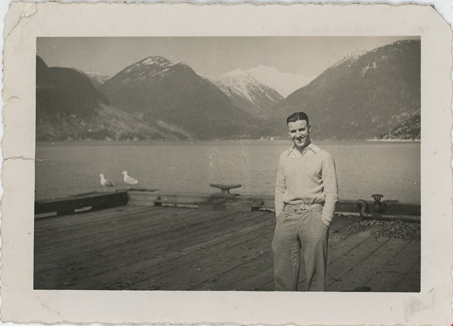
Crichton Hawkshaw standing on dock
https://search.heritageburnaby.ca/link/museumdescription19545
- Repository
- Burnaby Village Museum
- Date
- Apr. 1939
- Collection/Fonds
- Hawkshaw family fonds
- Description Level
- Item
- Physical Description
- 1 photograph : b&w ; 8.5 x 12 cm
- Scope and Content
- Photograph of Crichton Hawkshaw standing on a dock with view of mountains and Howe Sound behind him.
- Repository
- Burnaby Village Museum
- Collection/Fonds
- Hawkshaw family fonds
- Description Level
- Item
- Physical Description
- 1 photograph : b&w ; 8.5 x 12 cm
- Scope and Content
- Photograph of Crichton Hawkshaw standing on a dock with view of mountains and Howe Sound behind him.
- Subjects
- Geographic Features - Mountains
- Geographic Features - Natural Geographic Features
- Structures - Piers and Wharfs
- Accession Code
- BV996.6.252
- Access Restriction
- No restrictions
- Reproduction Restriction
- No known restrictions
- Date
- Apr. 1939
- Media Type
- Photograph
- Scan Date
- 2023-02-16
- Notes
- Title based on contents of photograph
- Caption beneath photograph reads: "April 1939"
- Photograph is part of photograph album BV996.6.1
Images