More like 'Capitol Hill'
Narrow Results By
Subject
- Advertising Medium - Signs and Signboards 3
- Aerial Photographs 2
- Animals 2
- Animals - Birds 6
- Arts - Paintings 5
- Buildings - Civic 3
- Buildings - Civic - City Halls 1
- Buildings - Civic - Museums 3
- Buildings - Commercial 3
- Buildings - Commercial - Restaurants 1
- Buildings - Commercial - Service Stations 3
- Buildings - Commercial - Stores 1

Widening of Scott Road
https://search.heritageburnaby.ca/link/archivedescription56677
- Repository
- City of Burnaby Archives
- Date
- March 1976, published March 24, 1976
- Collection/Fonds
- Columbian Newspaper collection
- Description Level
- Item
- Physical Description
- 1 photograph : b&w ; 7.5 x 14 cm
- Scope and Content
- Photograph of the process of widening Scott Road in Surrey BC. The process was undertaken by the provincial government. Citizens were upset as this process included cutting down century-old trees (stumps of these former trees are visible in this photograph).
- Repository
- City of Burnaby Archives
- Date
- March 1976, published March 24, 1976
- Collection/Fonds
- Columbian Newspaper collection
- Physical Description
- 1 photograph : b&w ; 7.5 x 14 cm
- Description Level
- Item
- Record No.
- 480-531
- Access Restriction
- No restrictions
- Reproduction Restriction
- No restrictions
- Accession Number
- 2003-02
- Scope and Content
- Photograph of the process of widening Scott Road in Surrey BC. The process was undertaken by the provincial government. Citizens were upset as this process included cutting down century-old trees (stumps of these former trees are visible in this photograph).
- Media Type
- Photograph
- Photographer
- King, Basil
- Notes
- Title based on contents of photograph
- Newspaper clipping attached to verso of photograph reads: "Road-widening on Scott Rd. in Surrey has taken its toll of old trees."
Images


Byrne Creek
https://search.heritageburnaby.ca/link/archivedescription36107
- Repository
- City of Burnaby Archives
- Date
- February 7, 1979
- Collection/Fonds
- Burnaby Historical Society fonds
- Description Level
- Item
- Physical Description
- 1 photograph : b&w ; 15 x 19.5 cm
- Scope and Content
- Photograph of Byrne Creek at a road's edge.
- Repository
- City of Burnaby Archives
- Date
- February 7, 1979
- Collection/Fonds
- Burnaby Historical Society fonds
- Subseries
- Columbian Newspaper subseries
- Physical Description
- 1 photograph : b&w ; 15 x 19.5 cm
- Description Level
- Item
- Record No.
- 222-030
- Access Restriction
- No restrictions
- Reproduction Restriction
- Reproduce for fair dealing purposes only
- Accession Number
- BHS1989-19
- Scope and Content
- Photograph of Byrne Creek at a road's edge.
- Media Type
- Photograph
- Photographer
- King, Basil
- Notes
- Title based on contents of photograph
- Newspaper clipping glued to verso of photograph reads: "Byrne Creek...fish habitat and a problem for developers."
- Geographic Access
- Byrne Creek
- Historic Neighbourhood
- Fraser Arm (Historic Neighbourhood)
- Planning Study Area
- Big Bend Area
Images

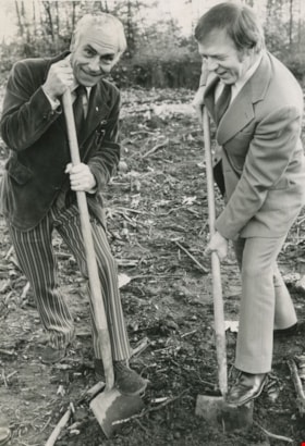
Tony Schmand with Mayor Tom Constable
https://search.heritageburnaby.ca/link/archivedescription45992
- Repository
- City of Burnaby Archives
- Date
- October 1973
- Collection/Fonds
- Columbian Newspaper collection
- Description Level
- Item
- Physical Description
- 1 photograph : b&w ; 20.5 x 14 cm
- Scope and Content
- Photograph of British Columbia Association for the Mentally Retarded president Tony Schmand with Mayor Tom Constable performing the sod turning ceremony for the site of a facility to accomodate the developmentally challenged in Burnaby.
- Repository
- City of Burnaby Archives
- Date
- October 1973
- Collection/Fonds
- Columbian Newspaper collection
- Physical Description
- 1 photograph : b&w ; 20.5 x 14 cm
- Description Level
- Item
- Record No.
- 480-887
- Access Restriction
- No restrictions
- Reproduction Restriction
- Reproduce for fair dealing purposes only
- Accession Number
- 2003-02
- Scope and Content
- Photograph of British Columbia Association for the Mentally Retarded president Tony Schmand with Mayor Tom Constable performing the sod turning ceremony for the site of a facility to accomodate the developmentally challenged in Burnaby.
- Subjects
- Land Clearing
- Ceremonies
- Media Type
- Photograph
- Photographer
- Battistoni, Peter
- Notes
- Title based on contents of photograph
- Geographic Access
- Banff Avenue
Images
Interview with Alekxos Sarter by Kathy Bossort October 16, 2015 - Track 7
https://search.heritageburnaby.ca/link/oralhistory583
- Repository
- City of Burnaby Archives
- Date Range
- 1963-2015
- Length
- 0:13:39
- Summary
- This portion of the interview is about Alekxos Sarter’s views on the origin and subsequent development and resolution of the dispute between SFU and the City of Burnaby over land ownership and land use on Burnaby Mountain.
- Repository
- City of Burnaby Archives
- Summary
- This portion of the interview is about Alekxos Sarter’s views on the origin and subsequent development and resolution of the dispute between SFU and the City of Burnaby over land ownership and land use on Burnaby Mountain.
- Date Range
- 1963-2015
- Length
- 0:13:39
- Subjects
- Geographic Features - Parks
- Government
- Land
- Geographic Access
- Burnaby Mountain Conservation Area
- Interviewer
- Bossort, Kathy
- Interview Date
- October 16, 2015
- Scope and Content
- Recording is of an interview with Alekxos Sarter conducted by Kathy Bossort. Alekxos Sarter was one of 23 participants interviewed as part of the Community Heritage Commission’s Burnaby Mountain Oral History Project. The interview is mainly about the history of setting aside parkland on Burnaby Mountain from Alekxos Sarter’s perspective and experience as employee in the City of Burnaby Parks, Recreation and Cultural Services. The interview provides an excellent explanation of the history and function of kinds of park dedications used by the City of Burnaby; an overview of issues around including the Trans Mountain tank farm in the conservation area; and the background to the land use and ownership disagreement between the City of Burnaby and Simon Fraser University, its resolution, and the subsequent development of SFU’s UniverCity. Alekxos Sarter talks about Richard Bolton, Burnaby’s Acting-Commissioner who was responsible for dedicating the first park on Burnaby Mountain in 1942, and the creation of a park named after him in UniverCity.
- Biographical Notes
- Alekxos Sarter was born in Vancouver in 1961, to Daine and Kasandra Sarter. She grew up in North Vancouver and since 1994 has lived on a sailboat in False Creek. After attending UBC where she studied landscape architecture, she was hired by the City of Burnaby Parks, Recreation and Cultural Services in 1986. Working first in parks design, Alekxos quickly moved into parks planning, her preferred career. As Research Officer she covers research, planning, public consultation, parks and facility inventory, parkland acquisition, among other duties.
- Total Tracks
- 9
- Total Length
- 2:20:47
- Interviewee Name
- Sarter, Alekxos T.
- Interview Location
- City of Burnaby Parks, Recreation and Cultural Services meeting room
- Interviewer Bio
- Kathy Bossort is a retired archivist living in Ladner, BC. She worked at the Delta Museum and Archives after graduating from SLAIS (UBC) in 2001 with Masters degrees in library science and archival studies. Kathy grew up in Calgary, Alberta, and, prior to this career change, she lived in the West Kootenays, earning her living as a cook for BC tourist lodges and work camps. She continues to be interested in oral histories as a way to fill the gaps in the written record and bring richer meaning to history.
- Collection/Fonds
- Community Heritage Commission Special Projects fonds
- Media Type
- Sound Recording
Audio Tracks
Track seven of interview with Alekxos Sarter
Track seven of interview with Alekxos Sarter
https://search.heritageburnaby.ca/media/hpo/_Data/_Archives_Oral_Histories/_Unrestricted/MSS196-005/MSS196-005_Track_7.mp3Interview with Barry Jones by Kathy Bossort December 9, 2015 - Track 4
https://search.heritageburnaby.ca/link/oralhistory667
- Repository
- City of Burnaby Archives
- Date Range
- 1975-1996
- Length
- 0:11:00
- Summary
- This portion of the interview is about Barry Jones’ talking briefly about serving as a trustee on the Burnaby Board of Education from 1975 to 1985 and as NDP MLA from 1986 to 1996, before describing his limited role in the dispute between the City of Burnaby and SFU over control and ownership of la…
- Repository
- City of Burnaby Archives
- Summary
- This portion of the interview is about Barry Jones’ talking briefly about serving as a trustee on the Burnaby Board of Education from 1975 to 1985 and as NDP MLA from 1986 to 1996, before describing his limited role in the dispute between the City of Burnaby and SFU over control and ownership of land on Burnaby Mountain. He talks about how the dispute was resolved and some of the terms in the agreement.
- Date Range
- 1975-1996
- Length
- 0:11:00
- Names
- Burnaby School Board
- Simon Fraser University
- Rankin, Lee A.
- Burnaby Mountain Conservation Area
- Geographic Access
- Burnaby Mountain Conservation Area
- Interviewer
- Bossort, Kathy
- Interview Date
- December 9, 2015
- Scope and Content
- Recording is of an interview with Barry Jones conducted by Kathy Bossort. Barry Jones was one of 23 participants interviewed as part of the Community Heritage Commission’s Burnaby Mountain Oral History Project. The interview is mainly about Barry Jones talking about his home and the conservation area on Burnaby Mountain, and about the negotiations that resulted in the agreement between Simon Fraser University and the City of Burnaby in 1995. He talks about the building of Burnaby Mountain Parkway and its link to the 1995 agreement, and about his experiences with Trans Mountain tank farm and pipeline. He also talks about his education and career as teacher, school board trustee and politician.
- Biographical Notes
- Barry Jones was born 1940 in Princeton, BC. His father moved the family to a home on Georgia Street in North Burnaby in 1944 where Barry grew up. He attended UBC majoring in mathematics and chemistry, and unable to find work in his field, taught two years in northern BC. He liked teaching and returned to school, enrolling in education at the newly opened Simon Fraser University in 1965. He taught one year at Moscrop Secondary School in Burnaby and finished his 25 year teaching career in Coquitlam. Barry served ten years as a Burnaby School board trustee, and then ten years as North Burnaby MLA (NDP) beginning in 1986, serving five years in Official Opposition and five years in government under then-premier Mike Harcourt. During his time in government, Barry Jones successfully lobbied for freedom of information legislation. He also played a role in resolving the dispute between SFU and Burnaby over control and ownership of land on Burnaby Mountain and in creating the Burnaby Mountain Conservation Area in 1995. He continues to live on Burnaby Mountain in a home he bought in 1971.
- Total Tracks
- 7
- Total Length
- 1:06:23
- Interviewee Name
- Jones, J. Barry
- Interview Location
- City of Burnaby City Hall law libary
- Interviewer Bio
- Kathy Bossort is a retired archivist living in Ladner, BC. She worked at the Delta Museum and Archives after graduating from SLAIS (UBC) in 2001 with Masters degrees in library science and archival studies. Kathy grew up in Calgary, Alberta, and, prior to this career change, she lived in the West Kootenays, earning her living as a cook for BC tourist lodges and work camps. She continues to be interested in oral histories as a way to fill the gaps in the written record and bring richer meaning to history.
- Collection/Fonds
- Community Heritage Commission Special Projects fonds
- Media Type
- Sound Recording
Audio Tracks
Track four of interview with Barry Jones
Track four of interview with Barry Jones
https://search.heritageburnaby.ca/media/hpo/_Data/_Archives_Oral_Histories/_Unrestricted/MSS196-015/MSS196-015_Track_4.mp3Interview with Basil Luksun and Jack Belhouse by Kathy Bossort November 24, 2015 - Track 7
https://search.heritageburnaby.ca/link/oralhistory633
- Repository
- City of Burnaby Archives
- Date Range
- 1963-2015
- Length
- 0:22:59
- Summary
- This portion of the interview is about Basil Luksun and Jack Belhouse’s description of the history of the dispute between the City of Burnaby and Simon Fraser University over land ownership and control on Burnaby Mountain. Basil Luksun provides a concise explanation of the differing sides to the di…
- Repository
- City of Burnaby Archives
- Summary
- This portion of the interview is about Basil Luksun and Jack Belhouse’s description of the history of the dispute between the City of Burnaby and Simon Fraser University over land ownership and control on Burnaby Mountain. Basil Luksun provides a concise explanation of the differing sides to the dispute, and both discuss the steps to the resolution, and the planning exercise leading to the SFU OCP and the development of UniverCity.
- Date Range
- 1963-2015
- Length
- 0:22:59
- Names
- Burnaby Mountain Conservation Area
- Simon Fraser University
- Burnaby Planning and Building Department
- Renger, Robert.
- UniverCity
- Subjects
- Government
- Land
- Geographic Features - Parks
- Geographic Access
- Burnaby Mountain Conservation Area
- Interviewer
- Bossort, Kathy
- Interview Date
- November 24, 2015
- Scope and Content
- Recording is of an interview with Basil Luksun and Jack Belhouse conducted by Kathy Bossort. Basil Luksun and Jack Belhouse were two of 23 participants interviewed as part of the Community Heritage Commission’s Burnaby Mountain Oral History Project. The interview is mainly about the history of setting aside parkland by dedication on Burnaby Mountain, the 1974/76 delineation of the conservation area on Burnaby Mountain, and the dispute between Burnaby and Simon Fraser University over land ownership and control on Burnaby Mountain, as discussed by two retired participants in these events from the City of Burnaby’s Planning and Building Department, Basil Luksun and Jack Belhouse. They also talk about their interaction with the public in developing policies, particularly for the 1974 report “The Public Meetings - Phase One”, and the importance of a strong policy base for long range planning and the patience needed to assemble land for large parks. They talk as well about their careers, their close working relationship in the department, and the cooperation between City and SFU staff in the development of UniverCity.
- Biographical Notes
- Basil Luksun was born and educated in South Africa, immigrating to Canada and Burnaby in 1972 to escape the harmful effects of apartheid. He holds a BSc degree from the University of Cape Town and a Post-Graduate Diploma in Town Planning from the University of Witwatersrand. He joined the City of Burnaby’s Planning and Building Department in 1973, working his way up through the organization to Director of the department before retiring after 39 years in 2012. When he started work in the 1970s, the City of Burnaby was focusing on green space planning projects and he takes great pride in these projects as well as the city’s focus on long-term planning. Basil lived in the Capital Hill area from 1972 to 1990. He currently resides in Vancouver and has two sons, Warren and Derek. Jack Belhouse was born in 1946 in Vancouver and attended UBC, York University and SFU (1965-1972), majoring in urban geography. He began working in Burnaby’s planning department as a summer student in 1968, and was offered a full-time position when he graduated from university. He became Director of the Planning and Building Department before retiring after 38 years with the city in 2006. He and Basil Luksun worked closely together in long range planning in the department. Jack lives in Coquitlam with his wife Linda and has two children, Brad and Lori.
- Total Tracks
- 8
- Total Length
- 1:58:23
- Interviewee Name
- Luksun, Basil
- Belhouse, Jack
- Interview Location
- Basil Luksun's home in Vancouver
- Interviewer Bio
- Kathy Bossort is a retired archivist living in Ladner, BC. She worked at the Delta Museum and Archives after graduating from SLAIS (UBC) in 2001 with Masters degrees in library science and archival studies. Kathy grew up in Calgary, Alberta, and, prior to this career change, she lived in the West Kootenays, earning her living as a cook for BC tourist lodges and work camps. She continues to be interested in oral histories as a way to fill the gaps in the written record and bring richer meaning to history.
- Collection/Fonds
- Community Heritage Commission Special Projects fonds
- Media Type
- Sound Recording
Audio Tracks
Track seven of interview with Basil Luksun and Jack Belhouse
Track seven of interview with Basil Luksun and Jack Belhouse
https://search.heritageburnaby.ca/media/hpo/_Data/_Archives_Oral_Histories/_Unrestricted/MSS196-012/MSS196-012_Track_7.mp3Interview with Leonard Evenden and Allen Seager by Kathy Bossort November 18, 2015 - Track 3
https://search.heritageburnaby.ca/link/oralhistory623
- Repository
- City of Burnaby Archives
- Date Range
- 1963-2015
- Length
- 0:17:29
- Summary
- This portion of the interview is about Dr. Evenden and Dr. Seager’s discussion about the relationship between Simon Fraser University and the City of Burnaby, and the origins and development of the dispute over land ownership and control on Burnaby Mountain, and factors that lead to the dispute's r…
- Repository
- City of Burnaby Archives
- Summary
- This portion of the interview is about Dr. Evenden and Dr. Seager’s discussion about the relationship between Simon Fraser University and the City of Burnaby, and the origins and development of the dispute over land ownership and control on Burnaby Mountain, and factors that lead to the dispute's resolution. They also talk about the challenges of SFU’s site for access, housing, and establishing a campus community.
- Date Range
- 1963-2015
- Length
- 0:17:29
- Names
- Simon Fraser University
- Harcourt, Mike
- Jones, J. Barry
- Burnaby Citizen's Association
- Burnaby Mountain Preservation Society
- Subjects
- Geographic Features - Parks
- Government
- Land
- Geographic Access
- Burnaby Mountain Conservation Area
- Interviewer
- Bossort, Kathy
- Interview Date
- November 18, 2015
- Scope and Content
- Recording is of an interview with Dr. Leonard Evenden and Dr. Allen Seager conducted by Kathy Bossort. Leonard Evenden and Allen Seager were two of 23 participants interviewed as part of the Community Heritage Commission’s Burnaby Mountain Oral History Project. The interview is mainly about aspects of Simon Fraser University’s history that is related to its site on Burnaby Mountain, as told by two retired SFU professors, Dr. Evenden of the Geography Department and Dr. Seager of the Department of History. The interview ranges over campus access and housing issues created by the isolated mountain site; the relationship of the university to the local community and the dispute over land ownership and control with the City of Burnaby; SFU’s environmental stewardship; the development of UniverCity; and the future of parkland in the conservation area on Burnaby Mountain.
- Biographical Notes
- Dr. Leonard J. Evenden was born 1937 in Beijing, China, to parents and Salvation Army missionaries Leonard Evenden and Elsie Pearl March. Dr. Evenden attended McMaster University (B.A. 1960), University of Georgia (M.A. 1962) and University of Edinburgh (Ph.D. 1970). He was appointed to Simon Fraser University’s Department of Geography in 1966, shortly after SFU opened in the fall of 1965, and retired in 2002. Dr. Evenden’s research has focused on Canadian urban geography. He edited a collection of essays about Burnaby titled “Suburb of Happy Homes: Burnaby centennial themes” (1995), and directed “Voices of Burnaby”, an SFU/Burnaby Centennial Committee oral history project (1992). Dr. Evenden is married with three children. Dr. Allen Seager was born 1953 in Montreal, Quebec, to parents C.F.B. Seager and Evelyn DeGex Chesam. Dr. Seager is a retired Simon Fraser University professor, being a member of SFU’s Department of History from 1981 to 2014, and has current links with SFU as an instructor for Continuing Studies. His research interests include history of Canada and Western Canada, and labour and working class history, particularly in the coal mining and railway industries. Dr. Seager moved to Burnaby and the Montecito area in 1981 where he continues to live and enjoy the hiking trails on Burnaby Mountain and the amenities at SFU. Dr. Seager is a member of the Burnaby North NDP, and has volunteered with Scouts Canada and the Burnaby Centennial Committee.
- Total Tracks
- 6
- Total Length
- 1:11:28
- Interviewee Name
- Evenden, Leonard J.
- Seager, Allen
- Interview Location
- Clubhouse at Burnaby Mountain Golf Course Restaurant
- Interviewer Bio
- Kathy Bossort is a retired archivist living in Ladner, BC. She worked at the Delta Museum and Archives after graduating from SLAIS (UBC) in 2001 with Masters degrees in library science and archival studies. Kathy grew up in Calgary, Alberta, and, prior to this career change, she lived in the West Kootenays, earning her living as a cook for BC tourist lodges and work camps. She continues to be interested in oral histories as a way to fill the gaps in the written record and bring richer meaning to history.
- Collection/Fonds
- Community Heritage Commission Special Projects fonds
- Media Type
- Sound Recording
Audio Tracks
Track three of interview with Dr. Leonard Evenden and Dr. Allen Seager
Track three of interview with Dr. Leonard Evenden and Dr. Allen Seager
https://search.heritageburnaby.ca/media/hpo/_Data/_Archives_Oral_Histories/_Unrestricted/MSS196-011/MSS196-011_Track_3.mp3Interview with Mayor Derek Corrigan by Kathy Bossort January 28, 2016 - Track 4
https://search.heritageburnaby.ca/link/oralhistory683
- Repository
- City of Burnaby Archives
- Date Range
- 1965-1995
- Length
- 0:12:49
- Summary
- This portion of the interview is about Mayor Corrigan talking about how to describe the relationship between the City of Burnaby and SFU between 1965 and 1995, and about proposals for development on Burnaby Mountain. He also talks about the change in public attitude toward protecting green spaces i…
- Repository
- City of Burnaby Archives
- Summary
- This portion of the interview is about Mayor Corrigan talking about how to describe the relationship between the City of Burnaby and SFU between 1965 and 1995, and about proposals for development on Burnaby Mountain. He also talks about the change in public attitude toward protecting green spaces in the 1970s and the City’s opportunity, awareness, and ability to preserve natural areas.
- Date Range
- 1965-1995
- Length
- 0:12:49
- Subjects
- Geographic Features - Parks
- Government
- Land
- Geographic Access
- Burnaby Mountain Conservation Area
- Interviewer
- Bossort, Kathy
- Interview Date
- January 28, 2016
- Scope and Content
- Recording is of an interview with Mayor Derek Corrigan conducted by Kathy Bossort. Derek Corrigan was one of 23 participants interviewed as part of the Community Heritage Commission’s Burnaby Mountain Oral History Project. The interview is mainly about Mayor Corrigan talking about the history and value of protecting the environment and green space in Burnaby, and the different positions held by the City and SFU about land use and control on Burnaby Mountain between 1964 and 1995. He talks about the increasing awareness that a solution needed to be found that gave certainty to the protection of the conservation area on Burnaby Mountain. Mayor Corrigan also talks about what conservation means to him, the role that the Centennial Pavilion area plays on Burnaby Mountain, and the future for the urban forest on Burnaby Mountain. Other topics include his childhood, education, formative events in his life, and his career in politics.
- Biographical Notes
- Derek Corrigan was born and grew up in Vancouver. He attended a number of elementary schools in East Vancouver, Queen Elizabeth Elementary School (Gr. 4-7) and Sir Charles Tupper High School. He attended UBC, majoring in philosophy and political science, and after travel in Europe, successfully applied to enter law school without completing his bachelors degree. He graduated in 1977, articled with Jim Lorimer in Burnaby and was called to the bar in 1978. In 1977 Derek Corrigan and his wife Kathy moved to Burnaby, first to the Stoney Creek neighborhood and then to a home on the South Slope where they raised their family of four children. Derek Corrigan first ran for Burnaby Council in 1979 with the Burnaby Citizens Association, and after three more tries was elected to council in 1987. He has served Burnaby for 28 years, first as a councillor and then as mayor since 2002. During his career he has served on many committees at the local, regional and national levels.
- Total Tracks
- 9
- Total Length
- 1:31:24
- Interviewee Name
- Corrigan, Derek
- Interview Location
- Mayor’s office at Burnaby City Hall
- Interviewer Bio
- Kathy Bossort is a retired archivist living in Ladner, BC. She worked at the Delta Museum and Archives after graduating from SLAIS (UBC) in 2001 with Masters degrees in library science and archival studies. Kathy grew up in Calgary, Alberta, and, prior to this career change, she lived in the West Kootenays, earning her living as a cook for BC tourist lodges and work camps. She continues to be interested in oral histories as a way to fill the gaps in the written record and bring richer meaning to history.
- Collection/Fonds
- Community Heritage Commission Special Projects fonds
- Media Type
- Sound Recording
Audio Tracks
Track four of interview with Mayor Derek Corrigan
Track four of interview with Mayor Derek Corrigan
https://search.heritageburnaby.ca/media/hpo/_Data/_Archives_Oral_Histories/_Unrestricted/MSS196-018/MSS196-018_Track_4.mp3Interview with Mayor Derek Corrigan by Kathy Bossort January 28, 2016 - Track 5
https://search.heritageburnaby.ca/link/oralhistory684
- Repository
- City of Burnaby Archives
- Date Range
- 1965-1995
- Length
- 0:09:15
- Summary
- This portion of the interview is about Mayor Corrigan talking about the positions held by the City and SFU about land use and control on Burnaby Mountain, and factors contributing to the differences in opinion, including SFU’s isolation and differences in position within SFU itself.
- Repository
- City of Burnaby Archives
- Summary
- This portion of the interview is about Mayor Corrigan talking about the positions held by the City and SFU about land use and control on Burnaby Mountain, and factors contributing to the differences in opinion, including SFU’s isolation and differences in position within SFU itself.
- Date Range
- 1965-1995
- Length
- 0:09:15
- Subjects
- Geographic Features - Parks
- Government
- Land
- Geographic Access
- Burnaby Mountain Conservation Area
- Interviewer
- Bossort, Kathy
- Interview Date
- January 28, 2016
- Scope and Content
- Recording is of an interview with Mayor Derek Corrigan conducted by Kathy Bossort. Derek Corrigan was one of 23 participants interviewed as part of the Community Heritage Commission’s Burnaby Mountain Oral History Project. The interview is mainly about Mayor Corrigan talking about the history and value of protecting the environment and green space in Burnaby, and the different positions held by the City and SFU about land use and control on Burnaby Mountain between 1964 and 1995. He talks about the increasing awareness that a solution needed to be found that gave certainty to the protection of the conservation area on Burnaby Mountain. Mayor Corrigan also talks about what conservation means to him, the role that the Centennial Pavilion area plays on Burnaby Mountain, and the future for the urban forest on Burnaby Mountain. Other topics include his childhood, education, formative events in his life, and his career in politics.
- Biographical Notes
- Derek Corrigan was born and grew up in Vancouver. He attended a number of elementary schools in East Vancouver, Queen Elizabeth Elementary School (Gr. 4-7) and Sir Charles Tupper High School. He attended UBC, majoring in philosophy and political science, and after travel in Europe, successfully applied to enter law school without completing his bachelors degree. He graduated in 1977, articled with Jim Lorimer in Burnaby and was called to the bar in 1978. In 1977 Derek Corrigan and his wife Kathy moved to Burnaby, first to the Stoney Creek neighborhood and then to a home on the South Slope where they raised their family of four children. Derek Corrigan first ran for Burnaby Council in 1979 with the Burnaby Citizens Association, and after three more tries was elected to council in 1987. He has served Burnaby for 28 years, first as a councillor and then as mayor since 2002. During his career he has served on many committees at the local, regional and national levels.
- Total Tracks
- 9
- Total Length
- 1:31:24
- Interviewee Name
- Corrigan, Derek
- Interview Location
- Mayor’s office at Burnaby City Hall
- Interviewer Bio
- Kathy Bossort is a retired archivist living in Ladner, BC. She worked at the Delta Museum and Archives after graduating from SLAIS (UBC) in 2001 with Masters degrees in library science and archival studies. Kathy grew up in Calgary, Alberta, and, prior to this career change, she lived in the West Kootenays, earning her living as a cook for BC tourist lodges and work camps. She continues to be interested in oral histories as a way to fill the gaps in the written record and bring richer meaning to history.
- Collection/Fonds
- Community Heritage Commission Special Projects fonds
- Media Type
- Sound Recording
Audio Tracks
Track five of interview with Mayor Derek Corrigan
Track five of interview with Mayor Derek Corrigan
https://search.heritageburnaby.ca/media/hpo/_Data/_Archives_Oral_Histories/_Unrestricted/MSS196-018/MSS196-018_Track_5.mp3Interview with Mayor Derek Corrigan by Kathy Bossort January 28, 2016 - Track 6
https://search.heritageburnaby.ca/link/oralhistory685
- Repository
- City of Burnaby Archives
- Date Range
- 1965-1995
- Length
- 0:17:56
- Summary
- This portion of the interview is about Mayor Corrigan talking about the City’s awareness by about 1990 for the need to do something to ensure the long range protection of the conservation area on Burnaby Mountain. He talks about the role Council, the Burnaby/Simon Fraser Liaison Committee, the Prov…
- Repository
- City of Burnaby Archives
- Summary
- This portion of the interview is about Mayor Corrigan talking about the City’s awareness by about 1990 for the need to do something to ensure the long range protection of the conservation area on Burnaby Mountain. He talks about the role Council, the Burnaby/Simon Fraser Liaison Committee, the Province and Mike Harcourt’s government, Burnaby Mountain Preservation Society, all contributed to finding a win/win solution for the City and the university.
- Date Range
- 1965-1995
- Length
- 0:17:56
- Names
- Simon Fraser Liaison Committee.
- Harcourt, Mike
- Burnaby Mountain Preservation Society
- Burnaby Mountain Conservation Area
- Simon Fraser University
- UniverCity
- Geographic Access
- Burnaby Mountain Conservation Area
- Interviewer
- Bossort, Kathy
- Interview Date
- January 28, 2016
- Scope and Content
- Recording is of an interview with Mayor Derek Corrigan conducted by Kathy Bossort. Derek Corrigan was one of 23 participants interviewed as part of the Community Heritage Commission’s Burnaby Mountain Oral History Project. The interview is mainly about Mayor Corrigan talking about the history and value of protecting the environment and green space in Burnaby, and the different positions held by the City and SFU about land use and control on Burnaby Mountain between 1964 and 1995. He talks about the increasing awareness that a solution needed to be found that gave certainty to the protection of the conservation area on Burnaby Mountain. Mayor Corrigan also talks about what conservation means to him, the role that the Centennial Pavilion area plays on Burnaby Mountain, and the future for the urban forest on Burnaby Mountain. Other topics include his childhood, education, formative events in his life, and his career in politics.
- Biographical Notes
- Derek Corrigan was born and grew up in Vancouver. He attended a number of elementary schools in East Vancouver, Queen Elizabeth Elementary School (Gr. 4-7) and Sir Charles Tupper High School. He attended UBC, majoring in philosophy and political science, and after travel in Europe, successfully applied to enter law school without completing his bachelors degree. He graduated in 1977, articled with Jim Lorimer in Burnaby and was called to the bar in 1978. In 1977 Derek Corrigan and his wife Kathy moved to Burnaby, first to the Stoney Creek neighborhood and then to a home on the South Slope where they raised their family of four children. Derek Corrigan first ran for Burnaby Council in 1979 with the Burnaby Citizens Association, and after three more tries was elected to council in 1987. He has served Burnaby for 28 years, first as a councillor and then as mayor since 2002. During his career he has served on many committees at the local, regional and national levels.
- Total Tracks
- 9
- Total Length
- 1:31:24
- Interviewee Name
- Corrigan, Derek
- Interview Location
- Mayor’s office at Burnaby City Hall
- Interviewer Bio
- Kathy Bossort is a retired archivist living in Ladner, BC. She worked at the Delta Museum and Archives after graduating from SLAIS (UBC) in 2001 with Masters degrees in library science and archival studies. Kathy grew up in Calgary, Alberta, and, prior to this career change, she lived in the West Kootenays, earning her living as a cook for BC tourist lodges and work camps. She continues to be interested in oral histories as a way to fill the gaps in the written record and bring richer meaning to history.
- Collection/Fonds
- Community Heritage Commission Special Projects fonds
- Media Type
- Sound Recording
Audio Tracks
Track six of interview with Mayor Derek Corrigan
Track six of interview with Mayor Derek Corrigan
https://search.heritageburnaby.ca/media/hpo/_Data/_Archives_Oral_Histories/_Unrestricted/MSS196-018/MSS196-018_Track_6.mp3![300 block of Esmonds, [between 1965 and 1970] thumbnail](/media/hpo/_Data/_Archives_Images/_Unrestricted/316/366-017.jpg?width=280)
300 block of Esmonds
https://search.heritageburnaby.ca/link/archivedescription37388
- Repository
- City of Burnaby Archives
- Date
- [between 1965 and 1970]
- Collection/Fonds
- Burnaby Historical Society fonds
- Description Level
- Item
- Physical Description
- 1 photograph : b&w negative
- Scope and Content
- Photograph taken looking south along the 300 block of Esmonds Avenue.
- Repository
- City of Burnaby Archives
- Date
- [between 1965 and 1970]
- Collection/Fonds
- Burnaby Historical Society fonds
- Subseries
- Municipal record subseries
- Physical Description
- 1 photograph : b&w negative
- Description Level
- Item
- Record No.
- 366-017
- Access Restriction
- No restrictions
- Reproduction Restriction
- Reproduce for fair dealing purposes only
- Accession Number
- BHS1998-12
- Scope and Content
- Photograph taken looking south along the 300 block of Esmonds Avenue.
- Subjects
- Geographic Features - Roads
- Media Type
- Photograph
- Notes
- Title based on contents of photograph
- Geographic Access
- Esmond Avenue
- Historic Neighbourhood
- Vancouver Heights (Historic Neighbourhood)
- Planning Study Area
- Burnaby Heights Area
Images
![300 block of Esmonds, [between 1965 and 1970] thumbnail](/media/hpo/_Data/_Archives_Images/_Unrestricted/316/366-017.jpg)
![3900 Albert Street, [between 1965 and 1970] thumbnail](/media/hpo/_Data/_Archives_Images/_Unrestricted/316/366-018.jpg?width=280)
3900 Albert Street
https://search.heritageburnaby.ca/link/archivedescription37389
- Repository
- City of Burnaby Archives
- Date
- [between 1965 and 1970]
- Collection/Fonds
- Burnaby Historical Society fonds
- Description Level
- Item
- Physical Description
- 1 photograph : b&w negative
- Scope and Content
- Photograph of the north side of 3900 Albert Street, looking west. The Vancouver Heights Baptist Church can be seen to the far right (at the corner of Albert Street and Ingleton Avenue).
- Repository
- City of Burnaby Archives
- Date
- [between 1965 and 1970]
- Collection/Fonds
- Burnaby Historical Society fonds
- Subseries
- Municipal record subseries
- Physical Description
- 1 photograph : b&w negative
- Description Level
- Item
- Record No.
- 366-018
- Access Restriction
- No restrictions
- Reproduction Restriction
- Reproduce for fair dealing purposes only
- Accession Number
- BHS1998-12
- Scope and Content
- Photograph of the north side of 3900 Albert Street, looking west. The Vancouver Heights Baptist Church can be seen to the far right (at the corner of Albert Street and Ingleton Avenue).
- Media Type
- Photograph
- Notes
- Title based on contents of photograph
- Geographic Access
- Ingleton Avenue
- Albert Street
- Street Address
- 3900 Albert Street
- 271 Ingleton Avenue
- 3977 Albert Street
- Historic Neighbourhood
- Vancouver Heights (Historic Neighbourhood)
- Planning Study Area
- Burnaby Heights Area
Images
![3900 Albert Street, [between 1965 and 1970] thumbnail](/media/hpo/_Data/_Archives_Images/_Unrestricted/316/366-018.jpg)
![3900 Albert Street at Ingleton Avenue, [between 1965 and 1970] thumbnail](/media/hpo/_Data/_Archives_Images/_Unrestricted/316/366-019.jpg?width=280)
3900 Albert Street at Ingleton Avenue
https://search.heritageburnaby.ca/link/archivedescription37390
- Repository
- City of Burnaby Archives
- Date
- [between 1965 and 1970]
- Collection/Fonds
- Burnaby Historical Society fonds
- Description Level
- Item
- Physical Description
- 1 photograph : b&w negative
- Scope and Content
- Photograph looking west along the north side of Albert Street from the 3900 Block. At the far right can be seen the Vancouver Heights Baptist Church, at the intersection of Albert and Ingleton Avenue.
- Repository
- City of Burnaby Archives
- Date
- [between 1965 and 1970]
- Collection/Fonds
- Burnaby Historical Society fonds
- Subseries
- Municipal record subseries
- Physical Description
- 1 photograph : b&w negative
- Description Level
- Item
- Record No.
- 366-019
- Access Restriction
- No restrictions
- Reproduction Restriction
- Reproduce for fair dealing purposes only
- Accession Number
- BHS1998-12
- Scope and Content
- Photograph looking west along the north side of Albert Street from the 3900 Block. At the far right can be seen the Vancouver Heights Baptist Church, at the intersection of Albert and Ingleton Avenue.
- Media Type
- Photograph
- Notes
- Title based on contents of photograph.
- Geographic Access
- Albert Street
- Ingleton Avenue
- Street Address
- 3900 Albert Street
- 271 Ingleton Avenue
- Historic Neighbourhood
- Vancouver Heights (Historic Neighbourhood)
- Planning Study Area
- Burnaby Heights Area
Images
![3900 Albert Street at Ingleton Avenue, [between 1965 and 1970] thumbnail](/media/hpo/_Data/_Archives_Images/_Unrestricted/316/366-019.jpg)
![3900 Hastings Street, [between 1965 and 1970] thumbnail](/media/hpo/_Data/_Archives_Images/_Unrestricted/316/366-010.jpg?width=280)
3900 Hastings Street
https://search.heritageburnaby.ca/link/archivedescription37381
- Repository
- City of Burnaby Archives
- Date
- [between 1965 and 1970]
- Collection/Fonds
- Burnaby Historical Society fonds
- Description Level
- Item
- Physical Description
- 1 photograph : b&w negative
- Scope and Content
- Photograph taken looking west along Hastings Street, in front of the 3900 Block.
- Repository
- City of Burnaby Archives
- Date
- [between 1965 and 1970]
- Collection/Fonds
- Burnaby Historical Society fonds
- Subseries
- Municipal record subseries
- Physical Description
- 1 photograph : b&w negative
- Description Level
- Item
- Record No.
- 366-010
- Access Restriction
- No restrictions
- Reproduction Restriction
- Reproduce for fair dealing purposes only
- Accession Number
- BHS1998-12
- Scope and Content
- Photograph taken looking west along Hastings Street, in front of the 3900 Block.
- Media Type
- Photograph
- Notes
- Title based on contents of photograph
- Geographic Access
- Hastings Street
- Historic Neighbourhood
- Vancouver Heights (Historic Neighbourhood)
- Planning Study Area
- Burnaby Heights Area
Images
![3900 Hastings Street, [between 1965 and 1970] thumbnail](/media/hpo/_Data/_Archives_Images/_Unrestricted/316/366-010.jpg)

Burris Street
https://search.heritageburnaby.ca/link/archivedescription36530
- Repository
- City of Burnaby Archives
- Date
- November 1978
- Collection/Fonds
- Burnaby Historical Society fonds
- Description Level
- Item
- Physical Description
- 1 photograph : col. ; 9 x 8.5 cm
- Scope and Content
- Photograph of Burris Street, including the "new" townhouse complex at One Arbour Lane when it was under construction.
- Repository
- City of Burnaby Archives
- Date
- November 1978
- Collection/Fonds
- Burnaby Historical Society fonds
- Subseries
- Lubbock family subseries
- Physical Description
- 1 photograph : col. ; 9 x 8.5 cm
- Description Level
- Item
- Record No.
- 289-019
- Access Restriction
- No restrictions
- Reproduction Restriction
- Reproduce for fair dealing purposes only
- Accession Number
- BHS1992-24
- Scope and Content
- Photograph of Burris Street, including the "new" townhouse complex at One Arbour Lane when it was under construction.
- Media Type
- Photograph
- Notes
- Title based on contents of photograph
- Geographic Access
- Burris Street
- Mayview Circle
- Historic Neighbourhood
- Burnaby Lake (Historic Neighbourhood)
- Planning Study Area
- Morley-Buckingham Area
Images


Crossing Royal Oak & Rumble Street
https://search.heritageburnaby.ca/link/archivedescription93686
- Repository
- City of Burnaby Archives
- Date
- May 19, 1978
- Collection/Fonds
- Burnaby Public Library Contemporary Visual Archive Project
- Description Level
- Item
- Physical Description
- 1 photograph : b&w ; 12.5 x 17.5 cm
- Scope and Content
- Photograph of the intersection of Royal Oak Avenue and Rumble Street. Cars and pedestrians are crossing the intersection, and the signs for businesses TD Bank, Standard Oil/Chevron gas station, Gulf gas station, and Baxter's Market are visible. The photograph is taken from a corner of the intersect…
- Repository
- City of Burnaby Archives
- Date
- May 19, 1978
- Collection/Fonds
- Burnaby Public Library Contemporary Visual Archive Project
- Physical Description
- 1 photograph : b&w ; 12.5 x 17.5 cm
- Description Level
- Item
- Record No.
- 556-643
- Access Restriction
- No restrictions
- Reproduction Restriction
- Reproduce for fair dealing purposes only
- Accession Number
- 2017-57
- Scope and Content
- Photograph of the intersection of Royal Oak Avenue and Rumble Street. Cars and pedestrians are crossing the intersection, and the signs for businesses TD Bank, Standard Oil/Chevron gas station, Gulf gas station, and Baxter's Market are visible. The photograph is taken from a corner of the intersection, facing southeast.
- Subjects
- Geographic Features - Roads
- Advertising Medium - Signs and Signboards
- Buildings - Commercial - Service Stations
- Transportation - Automobiles
- Buildings - Commercial
- Media Type
- Photograph
- Photographer
- van Mannen, Mark
- Notes
- Title taken from project information form
- Accompanied by a project information form and 1 photograph (b&w negative ; 9.5 x 12.5 cm)
- BPL no. 91
- Geographic Access
- Royal Oak Avenue
- Rumble Street
- Historic Neighbourhood
- Alta Vista (Historic Neighbourhood)
- Planning Study Area
- Sussex-Nelson Area
Images


Crossing Royal Oak & Rumble Street
https://search.heritageburnaby.ca/link/archivedescription93687
- Repository
- City of Burnaby Archives
- Date
- May 19, 1978
- Collection/Fonds
- Burnaby Public Library Contemporary Visual Archive Project
- Description Level
- Item
- Physical Description
- 1 photograph : b&w ; 12.5 x 17.5 cm
- Scope and Content
- Photograph of the intersection of Royal Oak Avenue and Rumble Street. Cars and pedestrians are crossing the intersection, and the signs for businesses Grace United Pharmacy, Standard Oil/Chevron gas station, Gulf gas station, and Royal Meats are visible. The photograph is taken from the Gulf gas st…
- Repository
- City of Burnaby Archives
- Date
- May 19, 1978
- Collection/Fonds
- Burnaby Public Library Contemporary Visual Archive Project
- Physical Description
- 1 photograph : b&w ; 12.5 x 17.5 cm
- Description Level
- Item
- Record No.
- 556-644
- Access Restriction
- No restrictions
- Reproduction Restriction
- Reproduce for fair dealing purposes only
- Accession Number
- 2017-57
- Scope and Content
- Photograph of the intersection of Royal Oak Avenue and Rumble Street. Cars and pedestrians are crossing the intersection, and the signs for businesses Grace United Pharmacy, Standard Oil/Chevron gas station, Gulf gas station, and Royal Meats are visible. The photograph is taken from the Gulf gas station parking lot, facing northwest.
- Subjects
- Advertising Medium - Signs and Signboards
- Geographic Features - Roads
- Transportation - Automobiles
- Buildings - Commercial
- Buildings - Commercial - Service Stations
- Media Type
- Photograph
- Photographer
- van Mannen, Mark
- Notes
- Title taken from project information form
- Accompanied by a project information form and 1 photograph (b&w negative ; 9.5 x 12.5 cm)
- BPL no. 92
- Geographic Access
- Royal Oak Avenue
- Rumble Street
- Historic Neighbourhood
- Alta Vista (Historic Neighbourhood)
- Planning Study Area
- Sussex-Nelson Area
Images


Deer Crossing Sign on Road to SFU
https://search.heritageburnaby.ca/link/archivedescription93671
- Repository
- City of Burnaby Archives
- Date
- January 18, 1978
- Collection/Fonds
- Burnaby Public Library Contemporary Visual Archive Project
- Description Level
- Item
- Physical Description
- 1 photograph : b&w ; 12.5 x 17.5 cm
- Scope and Content
- Photograph of the road to Simon Fraser University on Burnaby Mountain, with a deer crossing sign on the right-hand side of the photograph and a car driving ahead. The photograph appears to be taken from a car parked on the shoulder of the road, facing east.
- Repository
- City of Burnaby Archives
- Date
- January 18, 1978
- Collection/Fonds
- Burnaby Public Library Contemporary Visual Archive Project
- Physical Description
- 1 photograph : b&w ; 12.5 x 17.5 cm
- Description Level
- Item
- Record No.
- 556-628
- Access Restriction
- No restrictions
- Reproduction Restriction
- Reproduce for fair dealing purposes only
- Accession Number
- 2017-57
- Scope and Content
- Photograph of the road to Simon Fraser University on Burnaby Mountain, with a deer crossing sign on the right-hand side of the photograph and a car driving ahead. The photograph appears to be taken from a car parked on the shoulder of the road, facing east.
- Names
- Simon Fraser University
- Media Type
- Photograph
- Photographer
- Surridge, Jack
- Notes
- Title taken from project information form
- Accompanied by a project information form and 1 photograph (b&w negative ; 9.5 x 12.5 cm)
- BPL no. 77
- Geographic Access
- University Drive
- Burnaby Mountain Conservation Area
- Planning Study Area
- Burnaby Mountain Area
Images


The Freeway
https://search.heritageburnaby.ca/link/archivedescription45381
- Repository
- City of Burnaby Archives
- Date
- 1973
- Collection/Fonds
- Columbian Newspaper collection
- Description Level
- Item
- Physical Description
- 1 photograph : b&w ; 16 x 24 cm
- Scope and Content
- Photograph of the Freeway (now known as the Trans Canada Highway) with Capitol Hill visible in the background.
- Repository
- City of Burnaby Archives
- Date
- 1973
- Collection/Fonds
- Columbian Newspaper collection
- Physical Description
- 1 photograph : b&w ; 16 x 24 cm
- Description Level
- Item
- Record No.
- 480-276
- Access Restriction
- No restrictions
- Reproduction Restriction
- No restrictions
- Accession Number
- 2003-02
- Scope and Content
- Photograph of the Freeway (now known as the Trans Canada Highway) with Capitol Hill visible in the background.
- Subjects
- Geographic Features - Roads
- Media Type
- Photograph
- Photographer
- King, Basil
- Notes
- Title based on contents of photograph
- Note on recto of photograph reads: "Freeway with Capitol Hill (far right)"
- Geographic Access
- Trans Canada Highway
- Historic Neighbourhood
- Burnaby Lake (Historic Neighbourhood)
Images

![From 1855 18th Avenue, [1972 or 1973] (date of original), copied 1991 thumbnail](/media/hpo/_Data/_Archives_Images/_Unrestricted/370/370-263.jpg?width=280)
From 1855 18th Avenue
https://search.heritageburnaby.ca/link/archivedescription37675
- Repository
- City of Burnaby Archives
- Date
- [1972 or 1973] (date of original), copied 1991
- Collection/Fonds
- Burnaby Historical Society fonds
- Description Level
- Item
- Physical Description
- 1 photograph : b&w ; 3.9 x 3.9 cm print on contact sheet 20.2 x 25.3 cm
- Scope and Content
- Photograph taken from the front of 1855 18th Avenue (later renumbered as the 7000 block of 18th Avenue), looking north down the street in the snow.
- Repository
- City of Burnaby Archives
- Date
- [1972 or 1973] (date of original), copied 1991
- Collection/Fonds
- Burnaby Historical Society fonds
- Subseries
- Burnaby Image Bank subseries
- Physical Description
- 1 photograph : b&w ; 3.9 x 3.9 cm print on contact sheet 20.2 x 25.3 cm
- Description Level
- Item
- Record No.
- 370-263
- Access Restriction
- No restrictions
- Reproduction Restriction
- No restrictions
- Accession Number
- BHS1999-03
- Scope and Content
- Photograph taken from the front of 1855 18th Avenue (later renumbered as the 7000 block of 18th Avenue), looking north down the street in the snow.
- Media Type
- Photograph
- Notes
- Title based on contents of photograph
- 1 b&w copy negative accompanying
- Negative has a pink cast
- Copied from col. photograph
- Geographic Access
- 18th Avenue
- Historic Neighbourhood
- Edmonds (Historic Neighbourhood)
- Planning Study Area
- Stride Avenue Area
Images
![From 1855 18th Avenue, [1972 or 1973] (date of original), copied 1991 thumbnail](/media/hpo/_Data/_Archives_Images/_Unrestricted/370/370-263.jpg)