More like 'Nicomen Dykes'
Narrow Results By
Subject
- Accidents 1
- Accidents - Automobile Accidents 1
- Advertising Medium - Signs and Signboards 40
- Aerial Photographs 41
- Agricultural Tools and Equipment 2
- Agricultural Tools and Equipment - Gardening Equipment 4
- Agricultural Tools and Equipment - Plows 2
- Agriculture 3
- Agriculture - Farms 13
- Agriculture - Fruit and Berries 2
- Animals 4
- Animals - Bears 2

New Brunette Dam construction
https://search.heritageburnaby.ca/link/archivedescription35462
- Repository
- City of Burnaby Archives
- Date
- 1931 (date of original), copied 1986
- Collection/Fonds
- Burnaby Historical Society fonds
- Description Level
- Item
- Physical Description
- 1 photograph : b&w ; 12.7 x 17.8 cm print
- Scope and Content
- Photograph of the construction of new Brunette River dam.
- Repository
- City of Burnaby Archives
- Date
- 1931 (date of original), copied 1986
- Collection/Fonds
- Burnaby Historical Society fonds
- Subseries
- Pioneer Tales subseries
- Physical Description
- 1 photograph : b&w ; 12.7 x 17.8 cm print
- Description Level
- Item
- Record No.
- 204-320
- Access Restriction
- No restrictions
- Reproduction Restriction
- No known restrictions
- Accession Number
- BHS1988-03
- Scope and Content
- Photograph of the construction of new Brunette River dam.
- Media Type
- Photograph
- Notes
- Title based on contents of photograph
- Historic Neighbourhood
- Burquitlam (Historic Neighbourhood)
- Planning Study Area
- Burnaby Lake Area
Images

New Brunette River dam construction
https://search.heritageburnaby.ca/link/archivedescription35465
- Repository
- City of Burnaby Archives
- Date
- 1931 (date of original), copied 1986
- Collection/Fonds
- Burnaby Historical Society fonds
- Description Level
- Item
- Physical Description
- 1 photograph : b&w ; 12.7 x 17.8 cm print
- Scope and Content
- Photograph of the construction of new Brunette River dam and Cariboo Road bridge.
- Repository
- City of Burnaby Archives
- Date
- 1931 (date of original), copied 1986
- Collection/Fonds
- Burnaby Historical Society fonds
- Subseries
- Pioneer Tales subseries
- Physical Description
- 1 photograph : b&w ; 12.7 x 17.8 cm print
- Description Level
- Item
- Record No.
- 204-323
- Access Restriction
- No restrictions
- Reproduction Restriction
- No known restrictions
- Accession Number
- BHS1988-03
- Scope and Content
- Photograph of the construction of new Brunette River dam and Cariboo Road bridge.
- Media Type
- Photograph
- Notes
- Title based on contents of photograph
- Historic Neighbourhood
- Burquitlam (Historic Neighbourhood)
- Planning Study Area
- Burnaby Lake Area
Images

![New Kingsway and Nelson traffic lights, [2003] thumbnail](/media/hpo/_Data/_Archives_Images/_Unrestricted/535/535-1818.jpg?width=280)
New Kingsway and Nelson traffic lights
https://search.heritageburnaby.ca/link/archivedescription96113
- Repository
- City of Burnaby Archives
- Date
- [2003]
- Collection/Fonds
- Burnaby NewsLeader photograph collection
- Description Level
- Item
- Physical Description
- 1 photograph (tiff) : col.
- Scope and Content
- Photograph of an electrician carrying a new LED traffic light over his head at the intersection of Kingsway and Nelson.
- Repository
- City of Burnaby Archives
- Date
- [2003]
- Collection/Fonds
- Burnaby NewsLeader photograph collection
- Physical Description
- 1 photograph (tiff) : col.
- Description Level
- Item
- Record No.
- 535-1818
- Access Restriction
- No restrictions
- Reproduction Restriction
- No restrictions
- Accession Number
- 2018-12
- Scope and Content
- Photograph of an electrician carrying a new LED traffic light over his head at the intersection of Kingsway and Nelson.
- Subjects
- Construction
- Geographic Features - Roads
- Media Type
- Photograph
- Photographer
- Bartel, Mario
- Notes
- Title based on caption
- Collected by editorial for use in a January 2003 issue of the Burnaby NewsLeader
- Caption from metadata: "Bruce Quigley, of Cobra Electric, carries one of the new LED traffic lights to be installed by his partner, Chongor Lovey, at the corner of Kingsway and Nelson, in Burnaby. The city is replacing the lights at 195 intersections with the new, energy-efficient signals."
- Geographic Access
- Kingsway
- Nelson Avenue
- Historic Neighbourhood
- Central Park (Historic Neighbourhood)
- Planning Study Area
- Maywood Area
Images
![New Kingsway and Nelson traffic lights, [2003] thumbnail](/media/hpo/_Data/_Archives_Images/_Unrestricted/535/535-1818.jpg)

Oakland's Containment Ponds
https://search.heritageburnaby.ca/link/archivedescription91708
- Repository
- City of Burnaby Archives
- Date
- June 11, 1994
- Collection/Fonds
- Doreen Lawson fonds
- Description Level
- File
- Physical Description
- 20 photographs : col. slides ; 35 mm
- Scope and Content
- File consists of photographs of the containment ponds located on Oakland Street. Photographs depict the shallow ponds and surrounding area, as well as concrete storm drains and a raised wooden walkway and its supports. The creek adjacent to the ponds has not been identified.
- Repository
- City of Burnaby Archives
- Date
- June 11, 1994
- Collection/Fonds
- Doreen Lawson fonds
- Physical Description
- 20 photographs : col. slides ; 35 mm
- Description Level
- File
- Record No.
- 618-026
- Access Restriction
- No restrictions
- Reproduction Restriction
- No restrictions
- Accession Number
- 2015-15
- Scope and Content
- File consists of photographs of the containment ponds located on Oakland Street. Photographs depict the shallow ponds and surrounding area, as well as concrete storm drains and a raised wooden walkway and its supports. The creek adjacent to the ponds has not been identified.
- Media Type
- Photograph
- Photographer
- Lawson, Doreen A.
- Notes
- Transcribed title
- Title transcribed from note on recto of slide frame of photograph 618-026-19
- Geographic Access
- Oakland Street
Images

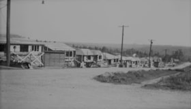
Parker Street, Napier Street and William Street
https://search.heritageburnaby.ca/link/archivedescription34208
- Repository
- City of Burnaby Archives
- Date
- June 25, 1947
- Collection/Fonds
- Burnaby Historical Society fonds
- Description Level
- Item
- Physical Description
- 1 photograph : b&w negative ; 6.8 x 11.4 cm
- Scope and Content
- Photograph of the 4200 blocks of Parker Street, Napier Street, William Street, and Charles Street with completed houses. This is part of the Willingdon Heights subdivision site.
- Repository
- City of Burnaby Archives
- Date
- June 25, 1947
- Collection/Fonds
- Burnaby Historical Society fonds
- Subseries
- Alfred Bingham subseries
- Physical Description
- 1 photograph : b&w negative ; 6.8 x 11.4 cm
- Description Level
- Item
- Record No.
- 010-124
- Access Restriction
- No restrictions
- Reproduction Restriction
- No known restrictions
- Accession Number
- BHS2007-04
- Scope and Content
- Photograph of the 4200 blocks of Parker Street, Napier Street, William Street, and Charles Street with completed houses. This is part of the Willingdon Heights subdivision site.
- Media Type
- Photograph
- Photographer
- Bingham, Alfred "Alf"
- Notes
- Title based on contents of photograph
- Geographic Access
- Parker Street
- Napier Street
- Charles Street
- William Street
Images

![Parkland, [1919] thumbnail](/media/hpo/_Data/_BVM_Images/1974/197500330003k.jpg?width=280)
Parkland
https://search.heritageburnaby.ca/link/museumdescription3495
- Repository
- Burnaby Village Museum
- Date
- [1919]
- Collection/Fonds
- Burnaby Village Museum Photograph collection
- Description Level
- Item
- Physical Description
- 1 photograph : b&w ; 13 x 8 cm
- Scope and Content
- Photograph of unidentified parkland with two steam-powered pile drivers visible in the distance.
- Repository
- Burnaby Village Museum
- Collection/Fonds
- Burnaby Village Museum Photograph collection
- Description Level
- Item
- Physical Description
- 1 photograph : b&w ; 13 x 8 cm
- Scope and Content
- Photograph of unidentified parkland with two steam-powered pile drivers visible in the distance.
- Accession Code
- HV975.33.3k
- Access Restriction
- No restrictions
- Date
- [1919]
- Media Type
- Photograph
- Scan Resolution
- 600
- Scan Date
- 2/2/2010
- Scale
- 100
- Notes
- Title based on contents of photograph
- Image from personal photograph album of Tom "Tommy" Irvine (HV975.33.3)
Images
![Parkland, [1919] thumbnail](/media/hpo/_Data/_BVM_Images/1974/197500330003k.jpg)
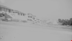
Rosser Avenue and William Street
https://search.heritageburnaby.ca/link/archivedescription34185
- Repository
- City of Burnaby Archives
- Date
- May 26, 1947
- Collection/Fonds
- Burnaby Historical Society fonds
- Description Level
- Item
- Physical Description
- 1 photograph : b&w negative ; 6.8 x 11.4 cm
- Scope and Content
- Photograph of Rosser Avenue and William Street with the road and cleared land in the foreground, and house construction and houses in the background. This is part of the Willingdon Heights subdivision site.
- Repository
- City of Burnaby Archives
- Date
- May 26, 1947
- Collection/Fonds
- Burnaby Historical Society fonds
- Subseries
- Alfred Bingham subseries
- Physical Description
- 1 photograph : b&w negative ; 6.8 x 11.4 cm
- Description Level
- Item
- Record No.
- 010-102
- Access Restriction
- No restrictions
- Reproduction Restriction
- No known restrictions
- Accession Number
- BHS2007-04
- Scope and Content
- Photograph of Rosser Avenue and William Street with the road and cleared land in the foreground, and house construction and houses in the background. This is part of the Willingdon Heights subdivision site.
- Media Type
- Photograph
- Photographer
- Bingham, Alfred "Alf"
- Notes
- Title based on contents of photograph
- Geographic Access
- Rosser Avenue
- William Street
Images
![Rower and dredger on Burnaby Lake, [1999] thumbnail](/media/hpo/_Data/_Archives_Images/_Unrestricted/535/535-3310.jpg?width=280)
Rower and dredger on Burnaby Lake
https://search.heritageburnaby.ca/link/archivedescription98232
- Repository
- City of Burnaby Archives
- Date
- [1999]
- Collection/Fonds
- Burnaby NewsLeader photograph collection
- Description Level
- Item
- Physical Description
- 1 photograph (tiff) : col.
- Scope and Content
- Photograph of an unidentified rower rowing on Burnaby Lake as a dredger works in the lake in the background.
- Repository
- City of Burnaby Archives
- Date
- [1999]
- Collection/Fonds
- Burnaby NewsLeader photograph collection
- Physical Description
- 1 photograph (tiff) : col.
- Description Level
- Item
- Record No.
- 535-3310
- Access Restriction
- No restrictions
- Reproduction Restriction
- No restrictions
- Accession Number
- 2018-12
- Scope and Content
- Photograph of an unidentified rower rowing on Burnaby Lake as a dredger works in the lake in the background.
- Subjects
- Recreational Activities - Boating
- Construction Tools and Equipment
- Geographic Features - Lakes and Ponds
- Media Type
- Photograph
- Notes
- Title based on original file name
- Collected by editorial for use in an August 1999 issue of the Burnaby NewsLeader
- Geographic Access
- Burnaby Lake
- Burnaby Lake Regional Nature Park
- Historic Neighbourhood
- Burnaby Lake (Historic Neighbourhood)
- Planning Study Area
- Burnaby Lake Area
Images
![Rower and dredger on Burnaby Lake, [1999] thumbnail](/media/hpo/_Data/_Archives_Images/_Unrestricted/535/535-3310.jpg)
![Steam powered pile driver, [1919] thumbnail](/media/hpo/_Data/_BVM_Images/1974/197500330003b.jpg?width=280)
Steam powered pile driver
https://search.heritageburnaby.ca/link/museumdescription3477
- Repository
- Burnaby Village Museum
- Date
- [1919]
- Collection/Fonds
- Burnaby Village Museum Photograph collection
- Description Level
- Item
- Physical Description
- 1 photograph : sepia ; 13.5 x 8 cm
- Scope and Content
- Photograph of a steam powered pile driver taking piles and laying them up on the tower. The pile driver then hammers the piles one by one into the riverbed. A mooring dolphin is visible in the foreground.
- Repository
- Burnaby Village Museum
- Collection/Fonds
- Burnaby Village Museum Photograph collection
- Description Level
- Item
- Physical Description
- 1 photograph : sepia ; 13.5 x 8 cm
- Scope and Content
- Photograph of a steam powered pile driver taking piles and laying them up on the tower. The pile driver then hammers the piles one by one into the riverbed. A mooring dolphin is visible in the foreground.
- Accession Code
- HV975.33.3b
- Access Restriction
- No restrictions
- Date
- [1919]
- Media Type
- Photograph
- Scan Resolution
- 600
- Scan Date
- 2/2/2010
- Scale
- 100
- Notes
- Title based on contents of photograph
- Image from personal photograph album of Tom "Tommy" Irvine (HV975.33.3)
Images
![Steam powered pile driver, [1919] thumbnail](/media/hpo/_Data/_BVM_Images/1974/197500330003b.jpg)
![Steam powered pile driver, [1919] thumbnail](/media/hpo/_Data/_BVM_Images/1974/197500330003z.jpg?width=280)
Steam powered pile driver
https://search.heritageburnaby.ca/link/museumdescription3511
- Repository
- Burnaby Village Museum
- Date
- [1919]
- Collection/Fonds
- Burnaby Village Museum Photograph collection
- Description Level
- Item
- Physical Description
- 1 photograph : sepia ; 13.5 x 8 cm
- Scope and Content
- Photograph of a steam powered pile driver taking piles and laying them up on the tower. The pile driver then hammers the piles one by one into the riverbed.
- Repository
- Burnaby Village Museum
- Collection/Fonds
- Burnaby Village Museum Photograph collection
- Description Level
- Item
- Physical Description
- 1 photograph : sepia ; 13.5 x 8 cm
- Scope and Content
- Photograph of a steam powered pile driver taking piles and laying them up on the tower. The pile driver then hammers the piles one by one into the riverbed.
- Accession Code
- HV975.33.3z
- Access Restriction
- No restrictions
- Date
- [1919]
- Media Type
- Photograph
- Scan Resolution
- 600
- Scan Date
- 2/2/2010
- Scale
- 100
- Notes
- Title based on contents of photograph
- Image from personal photograph album of Tom "Tommy" Irvine (HV975.33.3)
Images
![Steam powered pile driver, [1919] thumbnail](/media/hpo/_Data/_BVM_Images/1974/197500330003z.jpg)
![Westlawn Drive, [1953] thumbnail](/media/hpo/_Data/_Archives_Images/_Unrestricted/371/401-001.jpg?width=280)
Westlawn Drive
https://search.heritageburnaby.ca/link/archivedescription38304
- Repository
- City of Burnaby Archives
- Date
- [1953]
- Collection/Fonds
- Burnaby Historical Society fonds
- Description Level
- Item
- Physical Description
- 1 photograph : b&w ; 20.3 x 24.8 cm
- Scope and Content
- Photograph of Westlawn Drive, in the Brentwood area, under construction. A number of houses can be seen in various stages of construction and the road is unpaved.
- Repository
- City of Burnaby Archives
- Date
- [1953]
- Collection/Fonds
- Burnaby Historical Society fonds
- Subseries
- Jim Wolf subseries
- Physical Description
- 1 photograph : b&w ; 20.3 x 24.8 cm
- Description Level
- Item
- Record No.
- 401-001
- Access Restriction
- No restrictions
- Reproduction Restriction
- Reproduce for fair dealing purposes only
- Accession Number
- BHS2000-11
- Scope and Content
- Photograph of Westlawn Drive, in the Brentwood area, under construction. A number of houses can be seen in various stages of construction and the road is unpaved.
- Subjects
- Construction
- Geographic Features - Roads
- Media Type
- Photograph
- Notes
- Title based on contents of photograph.
- Geographic Access
- Westlawn Drive
- Planning Study Area
- Brentwood Area
Images
![Westlawn Drive, [1953] thumbnail](/media/hpo/_Data/_Archives_Images/_Unrestricted/371/401-001.jpg)
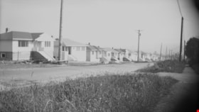
William Street
https://search.heritageburnaby.ca/link/archivedescription34231
- Repository
- City of Burnaby Archives
- Date
- August 12, 1947
- Collection/Fonds
- Burnaby Historical Society fonds
- Description Level
- Item
- Physical Description
- 1 photograph : b&w negative ; 6.8 x 11.4 cm
- Scope and Content
- Photograph of the 4100 block of William Street with houses under construction nearing completion on left side of street. This is part of the Willingdon Heights subdivision site.
- Repository
- City of Burnaby Archives
- Date
- August 12, 1947
- Collection/Fonds
- Burnaby Historical Society fonds
- Subseries
- Alfred Bingham subseries
- Physical Description
- 1 photograph : b&w negative ; 6.8 x 11.4 cm
- Description Level
- Item
- Record No.
- 010-143
- Access Restriction
- No restrictions
- Reproduction Restriction
- No known restrictions
- Accession Number
- BHS2007-04
- Scope and Content
- Photograph of the 4100 block of William Street with houses under construction nearing completion on left side of street. This is part of the Willingdon Heights subdivision site.
- Media Type
- Photograph
- Photographer
- Bingham, Alfred "Alf"
- Notes
- Title based on contents of photograph
- Geographic Access
- William Street
Images


William Street and Carleton Avenue
https://search.heritageburnaby.ca/link/archivedescription34249
- Repository
- City of Burnaby Archives
- Date
- August 30, 1947
- Collection/Fonds
- Burnaby Historical Society fonds
- Description Level
- Item
- Physical Description
- 1 photograph : b&w negative ; 6.8 x 11.4 cm
- Scope and Content
- Photograph of William Street and Carleton Avenue with a man inside a bulldozer-like machine clearing land. This is part of the Willingdon Heights subdivision site.
- Repository
- City of Burnaby Archives
- Date
- August 30, 1947
- Collection/Fonds
- Burnaby Historical Society fonds
- Subseries
- Alfred Bingham subseries
- Physical Description
- 1 photograph : b&w negative ; 6.8 x 11.4 cm
- Description Level
- Item
- Record No.
- 010-161
- Access Restriction
- No restrictions
- Reproduction Restriction
- No known restrictions
- Accession Number
- BHS2007-04
- Scope and Content
- Photograph of William Street and Carleton Avenue with a man inside a bulldozer-like machine clearing land. This is part of the Willingdon Heights subdivision site.
- Subjects
- Land Clearing
- Construction Tools and Equipment
- Geographic Features - Roads
- Occupations - Labourers
- Media Type
- Photograph
- Photographer
- Bingham, Alfred "Alf"
- Notes
- Title based on contents of photograph
- Geographic Access
- William Street
- Carleton Avenue
Images

William Street and Gilmore Avenue
https://search.heritageburnaby.ca/link/archivedescription34175
- Repository
- City of Burnaby Archives
- Date
- May 9, 1947
- Collection/Fonds
- Burnaby Historical Society fonds
- Description Level
- Item
- Physical Description
- 1 photograph : b&w negative ; 6.8 x 11.2 cm
- Scope and Content
- Photograph of the William Street and Gilmore Avenue intersection in the foreground and houses under construction on the left side of the road. This is part of the Willingdon Heights subdivision site.
- Repository
- City of Burnaby Archives
- Date
- May 9, 1947
- Collection/Fonds
- Burnaby Historical Society fonds
- Subseries
- Alfred Bingham subseries
- Physical Description
- 1 photograph : b&w negative ; 6.8 x 11.2 cm
- Description Level
- Item
- Record No.
- 010-092
- Access Restriction
- No restrictions
- Reproduction Restriction
- No known restrictions
- Accession Number
- BHS2007-04
- Scope and Content
- Photograph of the William Street and Gilmore Avenue intersection in the foreground and houses under construction on the left side of the road. This is part of the Willingdon Heights subdivision site.
- Media Type
- Photograph
- Photographer
- Bingham, Alfred "Alf"
- Notes
- Title based on contents of photograph
- Geographic Access
- William Street
- Gilmore Avenue
Images

William Street and Gilmore Avenue
https://search.heritageburnaby.ca/link/archivedescription34251
- Repository
- City of Burnaby Archives
- Date
- August 30, 1947
- Collection/Fonds
- Burnaby Historical Society fonds
- Description Level
- Item
- Physical Description
- 1 photograph : b&w negative ; 6.8 x 11.5 cm
- Scope and Content
- Photograph of William Street and Gilmore Avenue with completed houses on the left side of the street and a sidewalk on the right side. This is part of the Willingdon Heights subdivision site.
- Repository
- City of Burnaby Archives
- Date
- August 30, 1947
- Collection/Fonds
- Burnaby Historical Society fonds
- Subseries
- Alfred Bingham subseries
- Physical Description
- 1 photograph : b&w negative ; 6.8 x 11.5 cm
- Description Level
- Item
- Record No.
- 010-163
- Access Restriction
- No restrictions
- Reproduction Restriction
- No known restrictions
- Accession Number
- BHS2007-04
- Scope and Content
- Photograph of William Street and Gilmore Avenue with completed houses on the left side of the street and a sidewalk on the right side. This is part of the Willingdon Heights subdivision site.
- Media Type
- Photograph
- Photographer
- Bingham, Alfred "Alf"
- Notes
- Title based on contents of photograph
- Geographic Access
- William Street
- Gilmore Avenue
Images

William Street and Rosser Avenue
https://search.heritageburnaby.ca/link/archivedescription34224
- Repository
- City of Burnaby Archives
- Date
- July 31, 1947
- Collection/Fonds
- Burnaby Historical Society fonds
- Description Level
- Item
- Physical Description
- 1 photograph : b&w negative ; 6.8 x 11.1 cm
- Scope and Content
- Photograph of the intersection of William Street and Rosser Avenue. Houses under construction can be seen in the background. This is part of the Willingdon Heights subdivision site.
- Repository
- City of Burnaby Archives
- Date
- July 31, 1947
- Collection/Fonds
- Burnaby Historical Society fonds
- Subseries
- Alfred Bingham subseries
- Physical Description
- 1 photograph : b&w negative ; 6.8 x 11.1 cm
- Description Level
- Item
- Record No.
- 010-139-2
- Access Restriction
- No restrictions
- Reproduction Restriction
- No known restrictions
- Accession Number
- BHS2007-04
- Scope and Content
- Photograph of the intersection of William Street and Rosser Avenue. Houses under construction can be seen in the background. This is part of the Willingdon Heights subdivision site.
- Media Type
- Photograph
- Photographer
- Bingham, Alfred "Alf"
- Notes
- Title based on contents of photograph
- Geographic Access
- William Street
- Rosser Avenue
Images

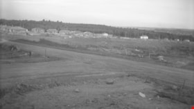
Willingdon Avenue and William Street
https://search.heritageburnaby.ca/link/archivedescription34184
- Repository
- City of Burnaby Archives
- Date
- May 20, 1947
- Collection/Fonds
- Burnaby Historical Society fonds
- Description Level
- Item
- Physical Description
- 1 photograph : b&w negative ; 6.8 x 11.2 cm
- Scope and Content
- Photograph of Willingdon Avenue and William Street with the road in the foreground, lumber and cleared land in the centre, and houses in the background. This is part of the Willingdon Heights subdivision site.
- Repository
- City of Burnaby Archives
- Date
- May 20, 1947
- Collection/Fonds
- Burnaby Historical Society fonds
- Subseries
- Alfred Bingham subseries
- Physical Description
- 1 photograph : b&w negative ; 6.8 x 11.2 cm
- Description Level
- Item
- Record No.
- 010-101
- Access Restriction
- No restrictions
- Reproduction Restriction
- No known restrictions
- Accession Number
- BHS2007-04
- Scope and Content
- Photograph of Willingdon Avenue and William Street with the road in the foreground, lumber and cleared land in the centre, and houses in the background. This is part of the Willingdon Heights subdivision site.
- Media Type
- Photograph
- Photographer
- Bingham, Alfred "Alf"
- Notes
- Title based on contents of photograph
- Geographic Access
- Willingdon Avenue
- William Street
Images
![Willingdon Heights subdivision, [1947] thumbnail](/media/hpo/_Data/_Archives_Images/_Unrestricted/001/010-139-1.jpg?width=280)
Willingdon Heights subdivision
https://search.heritageburnaby.ca/link/archivedescription39766
- Repository
- City of Burnaby Archives
- Date
- [1947]
- Collection/Fonds
- Burnaby Historical Society fonds
- Description Level
- Item
- Physical Description
- 1 photograph : b&w negative ; 6.8 x 11.1 cm
- Scope and Content
- Photograph of the street intersection at William and Rosser in the Willingdon Heights subdivision. Houses under construction can be seen in the background.
- Repository
- City of Burnaby Archives
- Date
- [1947]
- Collection/Fonds
- Burnaby Historical Society fonds
- Subseries
- Alfred Bingham subseries
- Physical Description
- 1 photograph : b&w negative ; 6.8 x 11.1 cm
- Description Level
- Item
- Record No.
- 010-139-1
- Access Restriction
- No restrictions
- Reproduction Restriction
- No known restrictions
- Accession Number
- BHS2007-04
- Scope and Content
- Photograph of the street intersection at William and Rosser in the Willingdon Heights subdivision. Houses under construction can be seen in the background.
- Media Type
- Photograph
- Photographer
- Bingham, Alfred "Alf"
- Notes
- Title based on contents of photograph
- Geographic Access
- William Street
- Rosser Avenue
Images
![Willingdon Heights subdivision, [1947] thumbnail](/media/hpo/_Data/_Archives_Images/_Unrestricted/001/010-139-1.jpg)
![Burnaby creek conservationists, [2002] thumbnail](/media/hpo/_Data/_Archives_Images/_Unrestricted/535/535-1959-1.jpg?width=280)
Burnaby creek conservationists
https://search.heritageburnaby.ca/link/archivedescription96276
- Repository
- City of Burnaby Archives
- Date
- [2002]
- Collection/Fonds
- Burnaby NewsLeader photograph collection
- Description Level
- File
- Physical Description
- 4 photographs (tiff) : col.
- Scope and Content
- File contains photographs of volunteer conservationists with the Eagle Creek Streamkeepers, Byrne Creek Streamkeepers, and Sapperton Fish & Game Club at work in the Lake City area by Eagle Creek and the Brunette River. Photographs depict Nick Kvenich, of the Eagle Creek Streamkeepers, in a creek; m…
- Repository
- City of Burnaby Archives
- Date
- [2002]
- Collection/Fonds
- Burnaby NewsLeader photograph collection
- Physical Description
- 4 photographs (tiff) : col.
- Description Level
- File
- Record No.
- 535-1959
- Access Restriction
- No restrictions
- Reproduction Restriction
- No restrictions
- Accession Number
- 2018-12
- Scope and Content
- File contains photographs of volunteer conservationists with the Eagle Creek Streamkeepers, Byrne Creek Streamkeepers, and Sapperton Fish & Game Club at work in the Lake City area by Eagle Creek and the Brunette River. Photographs depict Nick Kvenich, of the Eagle Creek Streamkeepers, in a creek; members of the Byrne Creek Streamkeepers observing a storm drain; and Elmer Rudolf feeding fish at a Sapperton Fish & Game Club hatchery.
- Subjects
- Geographic Features - Creeks
- Geographic Features - Lakes and Ponds
- Geographic Features - Ravines
- Geographic Features - Streams
- Media Type
- Photograph
- Photographer
- Bartel, Mario
- Notes
- Title based on caption
- Collected by editorial for use in a March 2002 issue of the Burnaby NewsLeader
- Caption from metadata for 535-1959-1: "Nick Kvenich is one of the founding members of the Eagle Creek Streamkeepers, which is looking to preserve the habitat of the creek that runs down from Squint Lake into a ravine below the Lake City industrial area."
- Caption from metadata for 535-1959-2: "Joan Carne (r) and Louise Towell, of the Byrne Creek Streamkeepers, examine a storm drain in an industrial area above the creek. The habitat faces constant pressure from businesses and homeowners who pour solvents, soaps and substances into the drains without thought to the consequences."
- Caption from metadata for 535-1959-3: "Nick Kvenich, one of the founding members of the Eagle Creek Streamkeepers, climbs through a fallen tree that is blocking a trail that runs alongside the creek, in a ravine below the Lake City industrial area. Although the tree will eventually be cleared by the GVRD, Kvenich says he prefers if such obstacles be left alone, as they would discourage people who might abuse the habitat."
- Caption from metadata for 535-1959-4: "Elmer Rudolf feeds a new batch of coho fry at the Sapperton Fish & Game Club's hatchery, near the Brunette River. The fry are normally fed by a timed conveyor belt, but that is supplemented by hand feedings to give the weaker fish a chance."
- Geographic Access
- Brunette River
- Eagle Creek
- Planning Study Area
- Lake City Area
Images
![Burnaby creek conservationists, [2002] thumbnail](/media/hpo/_Data/_Archives_Images/_Unrestricted/535/535-1959-1.jpg)
![View of lake, [191-] thumbnail](/media/hpo/_Data/_BVM_Images/2022/2022_0032_0093_001.jpg?width=280)
View of lake
https://search.heritageburnaby.ca/link/museumdescription19671
- Repository
- Burnaby Village Museum
- Date
- [191-]
- Collection/Fonds
- Esther Love Stanley fonds
- Description Level
- Item
- Physical Description
- 1 photograph : b&w ; 8.5 x 11 cm
- Scope and Content
- Photograph of view of lake with forest and shoreline (could be Stave Lake or Pitt Lake).
- Repository
- Burnaby Village Museum
- Collection/Fonds
- Esther Love Stanley fonds
- Description Level
- Item
- Physical Description
- 1 photograph : b&w ; 8.5 x 11 cm
- Scope and Content
- Photograph of view of lake with forest and shoreline (could be Stave Lake or Pitt Lake).
- Subjects
- Geographic Features - Natural Waterways
- Geographic Features
- Geographic Features - Natural Geographic Features
- Accession Code
- BV022.32.93
- Access Restriction
- No restrictions
- Reproduction Restriction
- No known restrictions
- Date
- [191-]
- Media Type
- Photograph
- Scan Resolution
- 600
- Scan Date
- 2023-04-04
- Notes
- Title based on contents of photograph
- Photograph is part of Esther Love Stanley photograph album 1 (BV022.32.1)
Images
![View of lake, [191-] thumbnail](/media/hpo/_Data/_BVM_Images/2022/2022_0032_0093_001.jpg)