More like 'Rosser Avenue and Napier Street'
Narrow Results By
Subject
- Accidents - Automobile Accidents 1
- Advertising Medium 3
- Advertising Medium - Signs and Signboards 93
- Aerial Photographs 29
- Agricultural Tools and Equipment - Plows 3
- Agriculture 2
- Agriculture - Crops 2
- Agriculture - Farms 51
- Agriculture - Fruit and Berries 6
- Agriculture - Poultry 4
- Animals 1
- Animals - Birds 2
![Anderson and Phillips Builders, [between 1910 and 1914] thumbnail](/media/hpo/_Data/_Archives_Images/_Unrestricted/487/487-029.jpg?width=280)
Anderson and Phillips Builders
https://search.heritageburnaby.ca/link/archivedescription57728
- Repository
- City of Burnaby Archives
- Date
- [between 1910 and 1914]
- Collection/Fonds
- J.W. Phillips fonds
- Description Level
- Item
- Physical Description
- 1 photograph : b&w glass negative ; 11 x 15.5 cm
- Scope and Content
- Photograph of a newly constructed house with land clearing debris and labourers working in the yard. A sign on the house reads; "Anderson and Phillips Builders", although the location and the specific individuals are unidentified (items no. 487-022 and 487-032 depict this house completed).
- Repository
- City of Burnaby Archives
- Date
- [between 1910 and 1914]
- Collection/Fonds
- J.W. Phillips fonds
- Physical Description
- 1 photograph : b&w glass negative ; 11 x 15.5 cm
- Material Details
- Emulsion measures 11 x 15.5 cm on the glass; entire glass plate measures 12 x 16 cm
- Description Level
- Item
- Record No.
- 487-029
- Access Restriction
- No restrictions
- Reproduction Restriction
- No known restrictions
- Accession Number
- 2008-18
- Scope and Content
- Photograph of a newly constructed house with land clearing debris and labourers working in the yard. A sign on the house reads; "Anderson and Phillips Builders", although the location and the specific individuals are unidentified (items no. 487-022 and 487-032 depict this house completed).
- Media Type
- Photograph
- Photographer
- Phillips, James William "Jim"
- Notes
- Title based on contents of photograph
Images
![Anderson and Phillips Builders, [between 1910 and 1914] thumbnail](/media/hpo/_Data/_Archives_Images/_Unrestricted/487/487-029.jpg)

B.G. Walker house
https://search.heritageburnaby.ca/link/archivedescription35002
- Repository
- City of Burnaby Archives
- Date
- 1910 (date of original), copied 1986
- Collection/Fonds
- Burnaby Historical Society fonds
- Description Level
- Item
- Physical Description
- 1 photograph : b&w postcard ; 8.4 x 13.8 cm
- Scope and Content
- Photographic postcard of the B.G. Walker house, Edmonds Street and Kingsway. Note the cedar stumps in background.
- Repository
- City of Burnaby Archives
- Date
- 1910 (date of original), copied 1986
- Collection/Fonds
- Burnaby Historical Society fonds
- Subseries
- Patterson family subseries
- Physical Description
- 1 photograph : b&w postcard ; 8.4 x 13.8 cm
- Description Level
- Item
- Record No.
- 171-023
- Access Restriction
- Open access
- Reproduction Restriction
- No known restrictions
- Accession Number
- BHS1986-20
- Scope and Content
- Photographic postcard of the B.G. Walker house, Edmonds Street and Kingsway. Note the cedar stumps in background.
- Media Type
- Photograph
- Notes
- Title based on contents of photograph
- Geographic Access
- Edmonds Street
- Kingsway
- Historic Neighbourhood
- Edmonds (Historic Neighbourhood)
Images


Gilmore Avenue and Douglas Road
https://search.heritageburnaby.ca/link/archivedescription34164
- Repository
- City of Burnaby Archives
- Date
- May 1, 1947
- Collection/Fonds
- Burnaby Historical Society fonds
- Description Level
- Item
- Physical Description
- 1 photograph : b&w negative ; 6.8 x 11.8 cm
- Scope and Content
- Photograph of cleared land at Gilmore Avenue and Douglas Road. Houses under construction can be seen in the background. This is part of the Willingdon Heights subdivision site.
- Repository
- City of Burnaby Archives
- Date
- May 1, 1947
- Collection/Fonds
- Burnaby Historical Society fonds
- Subseries
- Alfred Bingham subseries
- Physical Description
- 1 photograph : b&w negative ; 6.8 x 11.8 cm
- Description Level
- Item
- Record No.
- 010-081
- Access Restriction
- No restrictions
- Reproduction Restriction
- No known restrictions
- Accession Number
- BHS2007-04
- Scope and Content
- Photograph of cleared land at Gilmore Avenue and Douglas Road. Houses under construction can be seen in the background. This is part of the Willingdon Heights subdivision site.
- Subjects
- Industries - Construction
- Buildings - Residential - Houses
- Land Clearing
- Geographic Features - Roads
- Media Type
- Photograph
- Photographer
- Bingham, Alfred "Alf"
- Notes
- Title based on contents of photograph
- Geographic Access
- Gilmore Avenue
- Douglas Road
Images


Gilmore Avenue and Kitchener Street
https://search.heritageburnaby.ca/link/archivedescription34148
- Repository
- City of Burnaby Archives
- Date
- April 20, 1947
- Collection/Fonds
- Burnaby Historical Society fonds
- Description Level
- Item
- Physical Description
- 1 photograph : b&w negative ; 6.8 x 11.4 cm
- Scope and Content
- Photograph of Gilmore Avenue and Kitchener Street with cleared land and the beginning of house construction. This is part of the Willingdon Heights subdivision site.
- Repository
- City of Burnaby Archives
- Date
- April 20, 1947
- Collection/Fonds
- Burnaby Historical Society fonds
- Subseries
- Alfred Bingham subseries
- Physical Description
- 1 photograph : b&w negative ; 6.8 x 11.4 cm
- Description Level
- Item
- Record No.
- 010-064
- Access Restriction
- No restrictions
- Reproduction Restriction
- No known restrictions
- Accession Number
- BHS2007-04
- Scope and Content
- Photograph of Gilmore Avenue and Kitchener Street with cleared land and the beginning of house construction. This is part of the Willingdon Heights subdivision site.
- Media Type
- Photograph
- Photographer
- Bingham, Alfred "Alf"
- Notes
- Title based on contents of photograph
- Geographic Access
- Gilmore Avenue
- Kitchener Street
Images

, copied 1978 thumbnail](/media/hpo/_Data/_BVM_Images/1978/1978_0001_0003_001.jpg?width=280)
Haszard house
https://search.heritageburnaby.ca/link/museumdescription449
- Repository
- Burnaby Village Museum
- Date
- [190-](date of original), copied 1978
- Collection/Fonds
- Burnaby Village Museum Photograph collection
- Description Level
- Item
- Physical Description
- 1 photograph : b&w ; 20.2 x 25.2 cm print
- Scope and Content
- Photograph of a house in a clearing just on the outskirts of densely wooded area. There is a wooden fence around the property, and in front of the house is a dirt road. There are small piles of logs along the road side. An earlier catalogue record identifies this house as the Haszard house that was…
- Repository
- Burnaby Village Museum
- Collection/Fonds
- Burnaby Village Museum Photograph collection
- Description Level
- Item
- Physical Description
- 1 photograph : b&w ; 20.2 x 25.2 cm print
- Scope and Content
- Photograph of a house in a clearing just on the outskirts of densely wooded area. There is a wooden fence around the property, and in front of the house is a dirt road. There are small piles of logs along the road side. An earlier catalogue record identifies this house as the Haszard house that was located across the street from the property of the Sprott Farm. The photograph was taken from Douglas Road (later renamed in part Canada Way). It is also noted that the Sprott family lived in the Haszard house while their home, named "Dovecote" was being completed.
- Geographic Access
- Douglas Road
- Canada Way
- Accession Code
- HV978.1.3
- Access Restriction
- No restrictions
- Reproduction Restriction
- No known restrictions
- Date
- [190-](date of original), copied 1978
- Media Type
- Photograph
- Historic Neighbourhood
- Burnaby Lake (Historic Neighbourhood)
- Scan Resolution
- 600
- Scan Date
- 2023-07-25
- Notes
- Title based on contents of photograph
Images
, copied 1978 thumbnail](/media/hpo/_Data/_BVM_Images/1978/1978_0001_0003_001.jpg)

Kitchener Street
https://search.heritageburnaby.ca/link/archivedescription34154
- Repository
- City of Burnaby Archives
- Date
- April 20, 1947
- Collection/Fonds
- Burnaby Historical Society fonds
- Description Level
- Item
- Physical Description
- 1 photograph : b&w negative ; 6.8 x 11.4 cm
- Scope and Content
- Photograph of the 4200 block of Kitchener Street as cleared land. House construction can be seen in the background on the left. This is part of the Willingdon Heights subdivision site.
- Repository
- City of Burnaby Archives
- Date
- April 20, 1947
- Collection/Fonds
- Burnaby Historical Society fonds
- Subseries
- Alfred Bingham subseries
- Physical Description
- 1 photograph : b&w negative ; 6.8 x 11.4 cm
- Description Level
- Item
- Record No.
- 010-071
- Access Restriction
- No restrictions
- Reproduction Restriction
- No known restrictions
- Accession Number
- BHS2007-04
- Scope and Content
- Photograph of the 4200 block of Kitchener Street as cleared land. House construction can be seen in the background on the left. This is part of the Willingdon Heights subdivision site.
- Media Type
- Photograph
- Photographer
- Bingham, Alfred "Alf"
- Notes
- Title based on contents of photograph
- Geographic Access
- Kitchener Street
Images


Land clearing machines
https://search.heritageburnaby.ca/link/archivedescription34108
- Repository
- City of Burnaby Archives
- Date
- March 16, 1947
- Collection/Fonds
- Burnaby Historical Society fonds
- Description Level
- Item
- Physical Description
- 1 photograph : b&w negative ; 6.8 x 11.4 cm
- Scope and Content
- Photograph of land clearing machines at 4124 Napier Street. Partially constructed houses and lumber are visible, and a sign on the side of a bulldozer reads "Holmes and Wilson Trucking." This is part of the Willingdon Heights subdivision site.
- Repository
- City of Burnaby Archives
- Date
- March 16, 1947
- Collection/Fonds
- Burnaby Historical Society fonds
- Subseries
- Alfred Bingham subseries
- Physical Description
- 1 photograph : b&w negative ; 6.8 x 11.4 cm
- Description Level
- Item
- Record No.
- 010-024
- Access Restriction
- No restrictions
- Reproduction Restriction
- No known restrictions
- Accession Number
- BHS2007-04
- Scope and Content
- Photograph of land clearing machines at 4124 Napier Street. Partially constructed houses and lumber are visible, and a sign on the side of a bulldozer reads "Holmes and Wilson Trucking." This is part of the Willingdon Heights subdivision site.
- Media Type
- Photograph
- Photographer
- Bingham, Alfred "Alf"
- Notes
- Title based on contents of photograph
- Geographic Access
- Napier Street
- Street Address
- 4124 Napier Street
Images


Leer family
https://search.heritageburnaby.ca/link/archivedescription35195
- Repository
- City of Burnaby Archives
- Date
- 1911
- Collection/Fonds
- Burnaby Historical Society fonds
- Description Level
- Item
- Physical Description
- 1 photograph : b&w ; 12.7 x 17.8 cm print
- Scope and Content
- Photograph of the Leer family. From left to right: Richard Hedges, George Leer, Sarah Leer, and Ethel Leer. George Leer and his wife would be grandparents of Mayor William Lewarne. This photograph was taken in front of the Leer family home at Portland Street and McGregor Avenue.
- Repository
- City of Burnaby Archives
- Date
- 1911
- Collection/Fonds
- Burnaby Historical Society fonds
- Subseries
- Pioneer Tales subseries
- Physical Description
- 1 photograph : b&w ; 12.7 x 17.8 cm print
- Description Level
- Item
- Record No.
- 204-052
- Access Restriction
- No restrictions
- Reproduction Restriction
- No known restrictions
- Accession Number
- BHS1988-03
- Scope and Content
- Photograph of the Leer family. From left to right: Richard Hedges, George Leer, Sarah Leer, and Ethel Leer. George Leer and his wife would be grandparents of Mayor William Lewarne. This photograph was taken in front of the Leer family home at Portland Street and McGregor Avenue.
- Media Type
- Photograph
- Notes
- Title based on contents of photograph
- Geographic Access
- Portland Street
- McGregor Avenue
- Historic Neighbourhood
- Alta-Vista (Historic Neighbourhood)
- Planning Study Area
- Sussex-Nelson Area
Images


Madison Avenue
https://search.heritageburnaby.ca/link/archivedescription34243
- Repository
- City of Burnaby Archives
- Date
- August 20, 1947
- Collection/Fonds
- Burnaby Historical Society fonds
- Description Level
- Item
- Physical Description
- 1 photograph : b&w negative ; 6.8 x 11.4 cm
- Scope and Content
- Photograph of Madison Avenue (east) with the road and cleared land in the foreground, and houses in the background. This is part of the Willingdon Heights subdivision site.
- Repository
- City of Burnaby Archives
- Date
- August 20, 1947
- Collection/Fonds
- Burnaby Historical Society fonds
- Subseries
- Alfred Bingham subseries
- Physical Description
- 1 photograph : b&w negative ; 6.8 x 11.4 cm
- Description Level
- Item
- Record No.
- 010-155
- Access Restriction
- No restrictions
- Reproduction Restriction
- No known restrictions
- Accession Number
- BHS2007-04
- Scope and Content
- Photograph of Madison Avenue (east) with the road and cleared land in the foreground, and houses in the background. This is part of the Willingdon Heights subdivision site.
- Media Type
- Photograph
- Photographer
- Bingham, Alfred "Alf"
- Notes
- Title based on contents of photograph
- Geographic Access
- Madison Avenue
Images


Madison Avenue
https://search.heritageburnaby.ca/link/archivedescription34244
- Repository
- City of Burnaby Archives
- Date
- August 20, 1947
- Collection/Fonds
- Burnaby Historical Society fonds
- Description Level
- Item
- Physical Description
- 1 photograph : b&w negative ; 6.8 x 11.4 cm
- Scope and Content
- Photograph of Madison Avenue (southeast) with the road and cleared land in the foreground, and houses in the background. This is part of the Willingdon Heights subdivision site.
- Repository
- City of Burnaby Archives
- Date
- August 20, 1947
- Collection/Fonds
- Burnaby Historical Society fonds
- Subseries
- Alfred Bingham subseries
- Physical Description
- 1 photograph : b&w negative ; 6.8 x 11.4 cm
- Description Level
- Item
- Record No.
- 010-156
- Access Restriction
- No restrictions
- Reproduction Restriction
- No known restrictions
- Accession Number
- BHS2007-04
- Scope and Content
- Photograph of Madison Avenue (southeast) with the road and cleared land in the foreground, and houses in the background. This is part of the Willingdon Heights subdivision site.
- Media Type
- Photograph
- Photographer
- Bingham, Alfred "Alf"
- Notes
- Title based on contents of photograph
- Geographic Access
- Madison Avenue
Images


Madison Avenue and Kitchener Street
https://search.heritageburnaby.ca/link/archivedescription34240
- Repository
- City of Burnaby Archives
- Date
- August 20, 1947
- Collection/Fonds
- Burnaby Historical Society fonds
- Description Level
- Item
- Physical Description
- 1 photograph : b&w negative ; 6.8 x 13.1 cm
- Scope and Content
- Photograph of the 4200 block of Kitchener Street at Madison Avenue with cleared land and brush in foreground, and a bulldozer, lumber and houses under construction in background. This is part of the Willingdon Heights subdivision site.
- Repository
- City of Burnaby Archives
- Date
- August 20, 1947
- Collection/Fonds
- Burnaby Historical Society fonds
- Subseries
- Alfred Bingham subseries
- Physical Description
- 1 photograph : b&w negative ; 6.8 x 13.1 cm
- Description Level
- Item
- Record No.
- 010-152
- Access Restriction
- No restrictions
- Reproduction Restriction
- No known restrictions
- Accession Number
- BHS2007-04
- Scope and Content
- Photograph of the 4200 block of Kitchener Street at Madison Avenue with cleared land and brush in foreground, and a bulldozer, lumber and houses under construction in background. This is part of the Willingdon Heights subdivision site.
- Media Type
- Photograph
- Photographer
- Bingham, Alfred "Alf"
- Notes
- Title based on contents of photograph
- Geographic Access
- Kitchener Street
Images

![Newly constructed house, [between 1910 and 1914] thumbnail](/media/hpo/_Data/_Archives_Images/_Unrestricted/487/487-015.jpg?width=280)
Newly constructed house
https://search.heritageburnaby.ca/link/archivedescription57711
- Repository
- City of Burnaby Archives
- Date
- [between 1910 and 1914]
- Collection/Fonds
- J.W. Phillips fonds
- Description Level
- Item
- Physical Description
- 1 photograph : b&w glass negative ; 11 x 15.5 cm
- Scope and Content
- Photograph of a man sitting at the side of a newly constructed house, most likely in the Capitol Hill neighbourhood of Burnaby.
- Repository
- City of Burnaby Archives
- Date
- [between 1910 and 1914]
- Collection/Fonds
- J.W. Phillips fonds
- Physical Description
- 1 photograph : b&w glass negative ; 11 x 15.5 cm
- Material Details
- Emulsion measures 11 x 15.5 cm on the glass; entire glass plate measures 12 x 16 cm
- Description Level
- Item
- Record No.
- 487-015
- Access Restriction
- No restrictions
- Reproduction Restriction
- No known restrictions
- Accession Number
- 2008-18
- Scope and Content
- Photograph of a man sitting at the side of a newly constructed house, most likely in the Capitol Hill neighbourhood of Burnaby.
- Media Type
- Photograph
- Photographer
- Phillips, James William "Jim"
- Notes
- Title based on contents of photograph
- Historic Neighbourhood
- Central Park (Historic Neighbourhood)
- Planning Study Area
- Capitol Hill Area
Images
![Newly constructed house, [between 1910 and 1914] thumbnail](/media/hpo/_Data/_Archives_Images/_Unrestricted/487/487-015.jpg)

William Street and Carleton Avenue
https://search.heritageburnaby.ca/link/archivedescription34250
- Repository
- City of Burnaby Archives
- Date
- August 30, 1947
- Collection/Fonds
- Burnaby Historical Society fonds
- Description Level
- Item
- Physical Description
- 1 photograph : b&w negative ; 6.8 x 11.1 cm
- Scope and Content
- Photograph of William Street and Carleton Avenue with cleared land in the centre of the photograph and houses on the streets on either side. This is part of the Willingdon Heights subdivision site.
- Repository
- City of Burnaby Archives
- Date
- August 30, 1947
- Collection/Fonds
- Burnaby Historical Society fonds
- Subseries
- Alfred Bingham subseries
- Physical Description
- 1 photograph : b&w negative ; 6.8 x 11.1 cm
- Description Level
- Item
- Record No.
- 010-162
- Access Restriction
- No restrictions
- Reproduction Restriction
- No known restrictions
- Accession Number
- BHS2007-04
- Scope and Content
- Photograph of William Street and Carleton Avenue with cleared land in the centre of the photograph and houses on the streets on either side. This is part of the Willingdon Heights subdivision site.
- Media Type
- Photograph
- Photographer
- Bingham, Alfred "Alf"
- Notes
- Title based on contents of photograph
- Geographic Access
- William Street
- Carleton Avenue
Images

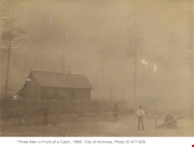
Three men in front of a cabin
https://search.heritageburnaby.ca/link/archivedescription39510
- Repository
- City of Burnaby Archives
- Date
- 1889
- Collection/Fonds
- Peers Family and Hill Family fonds
- Description Level
- Item
- Physical Description
- 1 photograph : b&w ; 10 x 14 cm on page 21.5 x 28 cm (pasted in album)
- Scope and Content
- Photograph of three men standing outside a fence next to a log cabin. The man standing to the right with the white shirt may be Claude Hill, but the others are unidentified. This cabin may have belonged to early Burnaby resident Charles Sprott. During the late 1880s and early 1890s, Charles Sprott…
- Repository
- City of Burnaby Archives
- Date
- 1889
- Collection/Fonds
- Peers Family and Hill Family fonds
- Physical Description
- 1 photograph : b&w ; 10 x 14 cm on page 21.5 x 28 cm (pasted in album)
- Description Level
- Item
- Record No.
- 477-829
- Access Restriction
- No restrictions
- Reproduction Restriction
- No known restrictions
- Accession Number
- 2007-12
- Scope and Content
- Photograph of three men standing outside a fence next to a log cabin. The man standing to the right with the white shirt may be Claude Hill, but the others are unidentified. This cabin may have belonged to early Burnaby resident Charles Sprott. During the late 1880s and early 1890s, Charles Sprott settled on a piece of land in Murrayville (Langley) near the border with the United States. When his cabin burned down in 1891, Sprott moved to Burnaby where another former Murrayville resident, Claude Hill had also relocated.
- Media Type
- Photograph
- Notes
- Title based on contents of photograph
Images

7026 Kingsway
https://search.heritageburnaby.ca/link/archivedescription94304
- Repository
- City of Burnaby Archives
- Date
- January 1994
- Collection/Fonds
- Grover, Elliott & Co. Ltd. fonds
- Description Level
- File
- Physical Description
- 19 photographs : col. negatives ; 35 mm
- Scope and Content
- Photographs of commercial and undeveloped properties located in the 7100 block of Kingsway, including Middlegate Honda, with mid-rise towers visible in the background.
- Repository
- City of Burnaby Archives
- Date
- January 1994
- Collection/Fonds
- Grover, Elliott & Co. Ltd. fonds
- Physical Description
- 19 photographs : col. negatives ; 35 mm
- Description Level
- File
- Record No.
- 622-089
- Access Restriction
- No restrictions
- Reproduction Restriction
- No restrictions
- Accession Number
- 2017-39
- Scope and Content
- Photographs of commercial and undeveloped properties located in the 7100 block of Kingsway, including Middlegate Honda, with mid-rise towers visible in the background.
- Media Type
- Photograph
- Notes
- Transcribed title
- Title transcribed from envelope photographs were originally housed in
- File no. 94-028-B
- Photographer identified as "L.D."
- Geographic Access
- Kingsway
- Historic Neighbourhood
- Edmonds (Historic Neighbourhood)
- Planning Study Area
- Stride Avenue Area
1160 Douglas Rd
https://search.heritageburnaby.ca/link/archivedescription94327
- Repository
- City of Burnaby Archives
- Date
- December 1994
- Collection/Fonds
- Grover, Elliott & Co. Ltd. fonds
- Description Level
- File
- Physical Description
- 22 photographs : col. negatives ; 35 mm
- Scope and Content
- Photographs of the exterior of a three-storey commerical building located at 1160 Douglas Road.
- Repository
- City of Burnaby Archives
- Date
- December 1994
- Collection/Fonds
- Grover, Elliott & Co. Ltd. fonds
- Physical Description
- 22 photographs : col. negatives ; 35 mm
- Description Level
- File
- Record No.
- 622-112
- Access Restriction
- No restrictions
- Reproduction Restriction
- No restrictions
- Accession Number
- 2017-39
- Scope and Content
- Photographs of the exterior of a three-storey commerical building located at 1160 Douglas Road.
- Media Type
- Photograph
- Photographer
- Young, Richard
- Notes
- Transcribed title
- Title transcribed from envelope photographs were originally housed in
- File no. 94-424-B
- Geographic Access
- Douglas Road
- Street Address
- 1160 Douglas Road
- Historic Neighbourhood
- Vancouver Heights (Historic Neighbourhood)
- Planning Study Area
- Willingdon Heights Area
8980 Fraserwood Crt
https://search.heritageburnaby.ca/link/archivedescription94326
- Repository
- City of Burnaby Archives
- Date
- December 1994
- Collection/Fonds
- Grover, Elliott & Co. Ltd. fonds
- Description Level
- File
- Physical Description
- 24 photographs : col. negatives ; 35 mm
- Scope and Content
- Photographs of an undeveloped property located at 8980 Fraserwood Court. A Sutton Group real estate sign on the property advertises the site as the Fraserwood Corporate Centre with strata warehouse and office flex space. File also contains photographs of the commerical building adjacent to the si…
- Repository
- City of Burnaby Archives
- Date
- December 1994
- Collection/Fonds
- Grover, Elliott & Co. Ltd. fonds
- Physical Description
- 24 photographs : col. negatives ; 35 mm
- Description Level
- File
- Record No.
- 622-111
- Access Restriction
- No restrictions
- Reproduction Restriction
- No restrictions
- Accession Number
- 2017-39
- Scope and Content
- Photographs of an undeveloped property located at 8980 Fraserwood Court. A Sutton Group real estate sign on the property advertises the site as the Fraserwood Corporate Centre with strata warehouse and office flex space. File also contains photographs of the commerical building adjacent to the site.
- Media Type
- Photograph
- Notes
- Transcribed title
- Title transcribed from envelope photographs were originally housed in
- File no. 94-422-B
- Photographer identified as "L.D."
- Geographic Access
- Fraserwood Court
- Street Address
- 8980 Fraserwood Court
- Historic Neighbourhood
- Fraser Arm (Historic Neighbourhood)
- Planning Study Area
- Big Bend Area
Burnaby
https://search.heritageburnaby.ca/link/archivedescription93751
- Repository
- City of Burnaby Archives
- Date
- 1991
- Collection/Fonds
- Grover, Elliott & Co. Ltd. fonds
- Description Level
- File
- Physical Description
- 43 photographs : col. negatives ; 35 mm
- Scope and Content
- Photographs of the exterior of a single-storey industrial building and surrounding undeveloped property. A sign on the building reads "Bauer". The location of the building has not been identified.
- Repository
- City of Burnaby Archives
- Date
- 1991
- Collection/Fonds
- Grover, Elliott & Co. Ltd. fonds
- Physical Description
- 43 photographs : col. negatives ; 35 mm
- Description Level
- File
- Record No.
- 622-036
- Access Restriction
- No restrictions
- Reproduction Restriction
- No restrictions
- Accession Number
- 2017-39
- Scope and Content
- Photographs of the exterior of a single-storey industrial building and surrounding undeveloped property. A sign on the building reads "Bauer". The location of the building has not been identified.
- Subjects
- Buildings - Industrial
- Land Clearing
- Media Type
- Photograph
- Notes
- Transcribed title
- Title transcribed from envelope photographs were originally housed in
- File no. 91-452-B
![Clearing for shopping centre, [1958] thumbnail](/media/hpo/_Data/_Archives_Images/_Unrestricted/559/564-002.jpg?width=280)
Clearing for shopping centre
https://search.heritageburnaby.ca/link/archivedescription85130
- Repository
- City of Burnaby Archives
- Date
- [1958]
- Collection/Fonds
- Ben Bradley collection
- Description Level
- Item
- Physical Description
- 1 photograph : b&w ; 8.2 x 11.5 cm
- Scope and Content
- Photograph of land being cleared for the Brentwood Mall with Burnaby mountain in the background.
- Repository
- City of Burnaby Archives
- Date
- [1958]
- Collection/Fonds
- Ben Bradley collection
- Physical Description
- 1 photograph : b&w ; 8.2 x 11.5 cm
- Description Level
- Item
- Record No.
- 564-002
- Access Restriction
- No restrictions
- Reproduction Restriction
- Reproduce for fair dealing purposes only
- Accession Number
- 2013-30
- Scope and Content
- Photograph of land being cleared for the Brentwood Mall with Burnaby mountain in the background.
- Subjects
- Buildings - Commercial
- Land Clearing
- Media Type
- Photograph
- Notes
- Transcribed title
- Note on verso reads: "Clearing for shopping centre"
- Street Address
- 4567 Lougheed Highway
- Planning Study Area
- Brentwood Area
Images
![Clearing for shopping centre, [1958] thumbnail](/media/hpo/_Data/_Archives_Images/_Unrestricted/559/564-002.jpg)
![Clearing for shopping centre, [1958] thumbnail](/media/hpo/_Data/_Archives_Images/_Unrestricted/559/564-003.jpg?width=280)
Clearing for shopping centre
https://search.heritageburnaby.ca/link/archivedescription85131
- Repository
- City of Burnaby Archives
- Date
- [1958]
- Collection/Fonds
- Ben Bradley collection
- Description Level
- Item
- Physical Description
- 1 photograph : b&w ; 8.2 x 11.5 cm
- Scope and Content
- Photograph with tree stumps, rocks and dirt of land being cleared for the Brentwood Mall.
- Repository
- City of Burnaby Archives
- Date
- [1958]
- Collection/Fonds
- Ben Bradley collection
- Physical Description
- 1 photograph : b&w ; 8.2 x 11.5 cm
- Description Level
- Item
- Record No.
- 564-003
- Access Restriction
- No restrictions
- Reproduction Restriction
- Reproduce for fair dealing purposes only
- Accession Number
- 2013-30
- Scope and Content
- Photograph with tree stumps, rocks and dirt of land being cleared for the Brentwood Mall.
- Subjects
- Buildings - Commercial
- Land Clearing
- Media Type
- Photograph
- Notes
- Title based on contents of photograph
- Street Address
- 4567 Lougheed Highway
- Planning Study Area
- Brentwood Area
Images
![Clearing for shopping centre, [1958] thumbnail](/media/hpo/_Data/_Archives_Images/_Unrestricted/559/564-003.jpg)