More like 'Stride family home'
Narrow Results By
Decade
- 2020s 105
- 2010s 49
- 2000s 462
- 1990s 390
- 1980s 412
- 1970s 1188
- 1960s 392
- 1950s 670
- 1940s 779
- 1930s 682
- 1920s 666
- 1910s 700
- 1900s 277
- 1890s 49
- 1880s 54
- 1870s 5
- 1860s 3
- 1850s 3
- 1840s 1
- 1830s 1
- 1820s 1
- 1810s 1
- 1800s 1
- 1790s 1
- 1780s 1
- 1770s 1
- 1760s 1
- 1750s 1
- 1740s 1
- 1730s 1
- 1720s 1
- 1710s 1
- 1700s 1
- 1690s 1
- 1680s 1
- 1670s 1
- 1660s 1
- 1650s 1
- 1640s 1
- 1630s 1
- 1620s 1
- 1610s 1
- 1600s 1
- 1520s 1
Subject
- Academic Disciplines 1
- Accidents 6
- Accidents - Automobile Accidents 10
- Accidents - Train Accidents 9
- Adornment - Jewelry 1
- Advertising Medium 5
- Advertising Medium - Poster 1
- Advertising Medium - Signs and Signboards 104
- Aerial Photographs 27
- Agricultural Tools and Equipment 5
- Agricultural Tools and Equipment - Gardening Equipment 2
- Agricultural Tools and Equipment - Plows 9
![Some of our homes, [1907] thumbnail](/media/hpo/_Data/_Archives_Images/_Unrestricted/371/411-006.jpg?width=280)
Some of our homes
https://search.heritageburnaby.ca/link/archivedescription38347
- Repository
- City of Burnaby Archives
- Date
- [1907]
- Collection/Fonds
- Burnaby Historical Society fonds
- Description Level
- Item
- Physical Description
- 1 photograph : b&w postcard ; 8.5 x 14 cm
- Scope and Content
- Photographic postcard of three houses at Barnet as well as the railway station. A caption on the card reads: "Some of our homes / Barnet B.C."
- Repository
- City of Burnaby Archives
- Date
- [1907]
- Collection/Fonds
- Burnaby Historical Society fonds
- Subseries
- Charles Lee subseries
- Physical Description
- 1 photograph : b&w postcard ; 8.5 x 14 cm
- Description Level
- Item
- Record No.
- 411-006
- Access Restriction
- No restrictions
- Reproduction Restriction
- No known restrictions
- Accession Number
- BHS2000-13
- Scope and Content
- Photographic postcard of three houses at Barnet as well as the railway station. A caption on the card reads: "Some of our homes / Barnet B.C."
- Subjects
- Buildings - Residential - Houses
- Documentary Artifacts - Postcards
- Buildings - Commercial - Train Stations
- Media Type
- Photograph
- Notes
- Title taken from caption
- Geographic Access
- Barnet Village
- Barnet Road
- Street Address
- 8181 Barnet Road
- Historic Neighbourhood
- Barnet (Historic Neighbourhood)
- Planning Study Area
- Burnaby Mountain Area
Images
![Some of our homes, [1907] thumbnail](/media/hpo/_Data/_Archives_Images/_Unrestricted/371/411-006.jpg)
![A Pretty Dwelling, Barnet, [191-] thumbnail](/media/hpo/_Data/_Archives_Images/_Unrestricted/540/540-027.jpg?width=280)
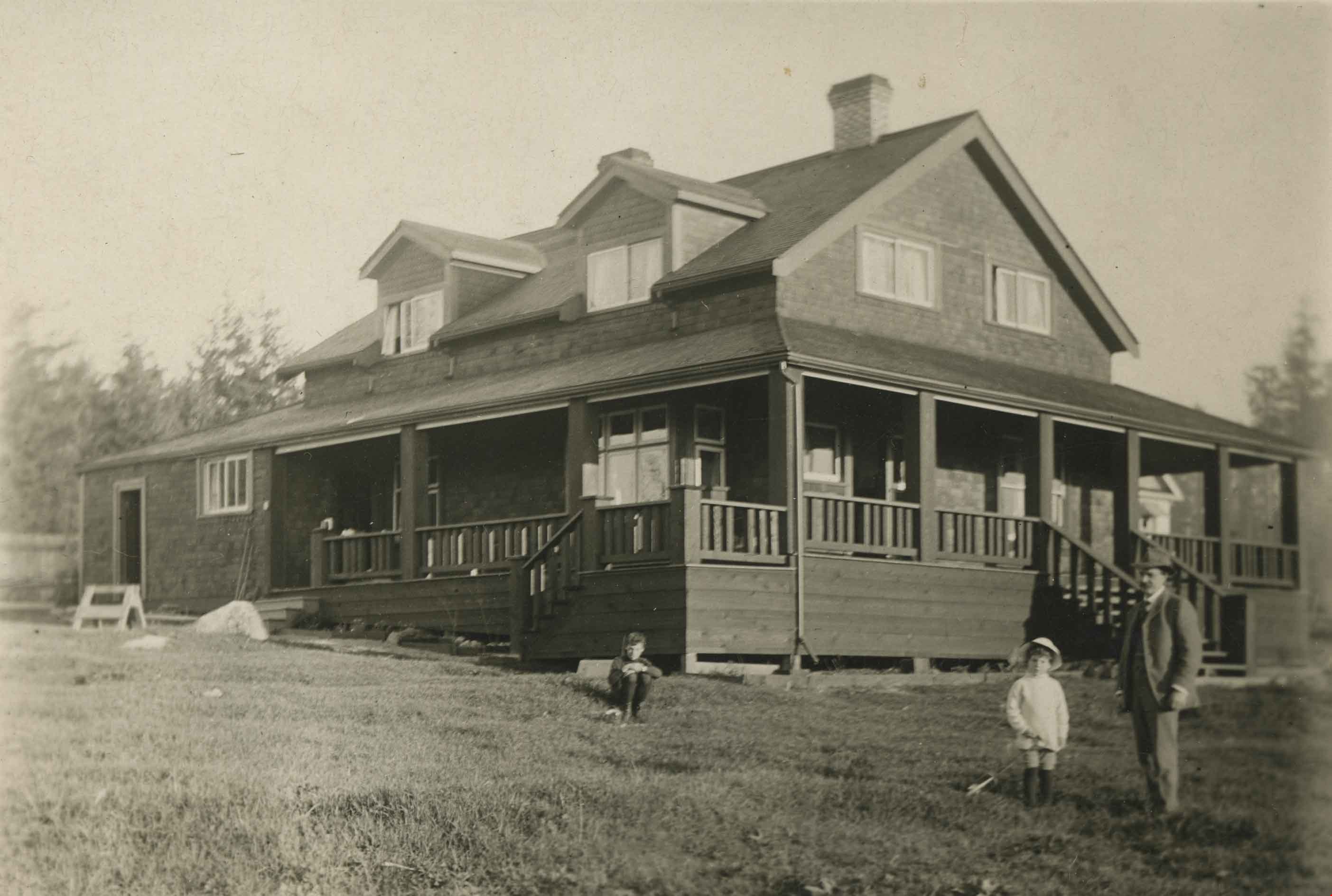
A Pretty Dwelling, Barnet
https://search.heritageburnaby.ca/link/archivedescription73619
- Repository
- City of Burnaby Archives
- Date
- [191-]
- Collection/Fonds
- LaFavor Family fonds
- Description Level
- Item
- Physical Description
- 1 photograph : sepia postcard ; 8.5 x 14 cm
- Scope and Content
- Photographic postcard of house in Barnet, BC, in which the image is entitled "A Pretty Dwelling."
- Repository
- City of Burnaby Archives
- Date
- [191-]
- Collection/Fonds
- LaFavor Family fonds
- Physical Description
- 1 photograph : sepia postcard ; 8.5 x 14 cm
- Description Level
- Item
- Record No.
- 540-027
- Access Restriction
- No restrictions
- Reproduction Restriction
- No restrictions
- Accession Number
- 2007-03
- Scope and Content
- Photographic postcard of house in Barnet, BC, in which the image is entitled "A Pretty Dwelling."
- Subjects
- Documentary Artifacts - Postcards
- Buildings - Residential - Houses
- Industries - Logging/lumber
- Names
- Barnet Mill
- Media Type
- Photograph
- Notes
- Transcribed title
- Geographic Access
- Barnet Village
- Texaco Drive
- Historic Neighbourhood
- Barnet (Historic Neighbourhood)
- Planning Study Area
- Burnaby Mountain Area
Images
![A Pretty Dwelling, Barnet, [191-] thumbnail](/media/hpo/_Data/_Archives_Images/_Unrestricted/540/540-027.jpg)
![A Pretty Dwelling, Barnet B.C., [1907] thumbnail](/media/hpo/_Data/_Archives_Images/_Unrestricted/371/411-008.jpg?width=280)
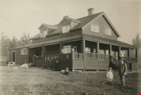
A Pretty Dwelling, Barnet B.C.
https://search.heritageburnaby.ca/link/archivedescription38349
- Repository
- City of Burnaby Archives
- Date
- [1907]
- Collection/Fonds
- Burnaby Historical Society fonds
- Description Level
- Item
- Physical Description
- 1 photograph : sepia postcard ; 8.5 x 14 cm
- Scope and Content
- Photograph of the front garden and exterior of the North Pacific Lumber Co. (NPLC) Manager's house at Barnet. The caption on the card reads: "A Pretty Dwelling, Barnet B.C."
- Repository
- City of Burnaby Archives
- Date
- [1907]
- Collection/Fonds
- Burnaby Historical Society fonds
- Subseries
- Charles Lee subseries
- Physical Description
- 1 photograph : sepia postcard ; 8.5 x 14 cm
- Description Level
- Item
- Record No.
- 411-008
- Access Restriction
- No restrictions
- Reproduction Restriction
- No known restrictions
- Accession Number
- BHS2000-13
- Scope and Content
- Photograph of the front garden and exterior of the North Pacific Lumber Co. (NPLC) Manager's house at Barnet. The caption on the card reads: "A Pretty Dwelling, Barnet B.C."
- Media Type
- Photograph
- Notes
- Title taken from caption
- Geographic Access
- Barnet Village
- Barnet Road
- Street Address
- 8181 Barnet Road
- Historic Neighbourhood
- Barnet (Historic Neighbourhood)
- Planning Study Area
- Burnaby Mountain Area
Images
![A Pretty Dwelling, Barnet B.C., [1907] thumbnail](/media/hpo/_Data/_Archives_Images/_Unrestricted/371/411-008.jpg)

B.G. Walker house
https://search.heritageburnaby.ca/link/archivedescription35002
- Repository
- City of Burnaby Archives
- Date
- 1910 (date of original), copied 1986
- Collection/Fonds
- Burnaby Historical Society fonds
- Description Level
- Item
- Physical Description
- 1 photograph : b&w postcard ; 8.4 x 13.8 cm
- Scope and Content
- Photographic postcard of the B.G. Walker house, Edmonds Street and Kingsway. Note the cedar stumps in background.
- Repository
- City of Burnaby Archives
- Date
- 1910 (date of original), copied 1986
- Collection/Fonds
- Burnaby Historical Society fonds
- Subseries
- Patterson family subseries
- Physical Description
- 1 photograph : b&w postcard ; 8.4 x 13.8 cm
- Description Level
- Item
- Record No.
- 171-023
- Access Restriction
- Open access
- Reproduction Restriction
- No known restrictions
- Accession Number
- BHS1986-20
- Scope and Content
- Photographic postcard of the B.G. Walker house, Edmonds Street and Kingsway. Note the cedar stumps in background.
- Media Type
- Photograph
- Notes
- Title based on contents of photograph
- Geographic Access
- Edmonds Street
- Kingsway
- Historic Neighbourhood
- Edmonds (Historic Neighbourhood)
Images

![Fred Holdsworth and his wife in front of their house, [1912] thumbnail](/media/hpo/_Data/_BVM_Images/1977/198000120001.jpg?width=280)
Fred Holdsworth and his wife in front of their house
https://search.heritageburnaby.ca/link/museumdescription3029
- Repository
- Burnaby Village Museum
- Date
- [1912]
- Collection/Fonds
- Burnaby Village Museum Photograph collection
- Description Level
- Item
- Physical Description
- 1 photograph : b&w postcard ; 13.9 x 8.5 cm
- Scope and Content
- Photographic postcard of Fred Holdsworth and his wife standing outside their Neville Street Home. The house is two storeys with an attic with windows. The porch is elevated with steep stairs leading to the front door, which is on the second floor. They are both standing with their hands on their hi…
- Repository
- Burnaby Village Museum
- Collection/Fonds
- Burnaby Village Museum Photograph collection
- Description Level
- Item
- Physical Description
- 1 photograph : b&w postcard ; 13.9 x 8.5 cm
- Scope and Content
- Photographic postcard of Fred Holdsworth and his wife standing outside their Neville Street Home. The house is two storeys with an attic with windows. The porch is elevated with steep stairs leading to the front door, which is on the second floor. They are both standing with their hands on their hips. There are variant spellings of "Holdsworth" used in the notes in the accession file. They are "Houldsworth" and "Hallsworth." The 1937 British Columbia directory lists a Fred Houldsworth at 3345 Neville Street, Burnaby. The address was later renumbered 5249 Neville Street.
- Geographic Access
- Neville Street
- Street Address
- 5249 Neville Street
- Accession Code
- HV980.12.1
- Access Restriction
- No restrictions
- Reproduction Restriction
- May be restricted by third party rights
- Date
- [1912]
- Media Type
- Photograph
- Historic Neighbourhood
- Alta-Vista (Historic Neighbourhood)
- Planning Study Area
- Clinton-Glenwood Area
- Scan Resolution
- 600
- Scan Date
- 2023-09-12
- Notes
- Title based on contents of photograph
Images
![Fred Holdsworth and his wife in front of their house, [1912] thumbnail](/media/hpo/_Data/_BVM_Images/1977/198000120001.jpg)
Greyfriars
https://search.heritageburnaby.ca/link/archivedescription34294
- Repository
- City of Burnaby Archives
- Date
- 1912
- Collection/Fonds
- Burnaby Historical Society fonds
- Description Level
- Item
- Physical Description
- 1 photograph : b&w postcard ; 8.8 x 13.5 cm
- Scope and Content
- Photographic postcard of "Greyfriars," the F.J. Peers House in the Burnaby Lake area. Standing in front of the home are two children and a man who may be Francis J. Peers. The children are unidentified.
- Repository
- City of Burnaby Archives
- Date
- 1912
- Collection/Fonds
- Burnaby Historical Society fonds
- Subseries
- Peers family subseries
- Physical Description
- 1 photograph : b&w postcard ; 8.8 x 13.5 cm
- Description Level
- Item
- Record No.
- 020-001
- Access Restriction
- No restrictions
- Reproduction Restriction
- No known restrictions
- Accession Number
- BHS2007-04
- Scope and Content
- Photographic postcard of "Greyfriars," the F.J. Peers House in the Burnaby Lake area. Standing in front of the home are two children and a man who may be Francis J. Peers. The children are unidentified.
- Names
- Peers, Francis J.
- Media Type
- Photograph
- Notes
- Title based on contents of photograph
- Geographic Access
- Rugby Street
- Street Address
- 5289 Rugby Avenue
- Historic Neighbourhood
- Burnaby Lake (Historic Neighbourhood)
- Planning Study Area
- Morley-Buckingham Area
Images
![Holdsworth House on Neville Street, [1912] thumbnail](/media/hpo/_Data/_BVM_Images/1977/198000120002.jpg?width=280)
Holdsworth House on Neville Street
https://search.heritageburnaby.ca/link/museumdescription3030
- Repository
- Burnaby Village Museum
- Date
- [1912]
- Collection/Fonds
- Burnaby Village Museum Photograph collection
- Description Level
- Item
- Physical Description
- 1 photograph : sepia postcard ; 8.8 x 13.8 cm
- Scope and Content
- Photographic postcard of the Holdsworth house on Neville Street. The house is two storeys with an attic with windows. The porch is elevated with steep stairs leading to the front door, which is on the second floor. There is a woman standing in the porch, looking towards the photographer. Another ho…
- Repository
- Burnaby Village Museum
- Collection/Fonds
- Burnaby Village Museum Photograph collection
- Description Level
- Item
- Physical Description
- 1 photograph : sepia postcard ; 8.8 x 13.8 cm
- Scope and Content
- Photographic postcard of the Holdsworth house on Neville Street. The house is two storeys with an attic with windows. The porch is elevated with steep stairs leading to the front door, which is on the second floor. There is a woman standing in the porch, looking towards the photographer. Another house is visible right beside the Holdsworth house. There are variant spellings of "Holdsworth" used in the notes in the accession file. They are "Houldsworth" and "Hallsworth." The 1937 British Columbia directory lists a Fred Houldsworth at 3345 Neville Street, Burnaby. The address was later renumbered 5249 Neville Street.
- Geographic Access
- Neville Street
- Street Address
- 5249 Neville Street
- Accession Code
- HV980.12.2
- Access Restriction
- No restrictions
- Reproduction Restriction
- May be restricted by third party rights
- Date
- [1912]
- Media Type
- Photograph
- Historic Neighbourhood
- Alta-Vista (Historic Neighbourhood)
- Planning Study Area
- Clinton-Glenwood Area
- Scan Resolution
- 600
- Scan Date
- 2023-09-12
- Notes
- Title based on contents of photograph
Images
![Holdsworth House on Neville Street, [1912] thumbnail](/media/hpo/_Data/_BVM_Images/1977/198000120002.jpg)
![Home of Arthur Lobley and his wife, [1915] thumbnail](/media/hpo/_Data/_BVM_Images/1976/1976_0236_0001_001.jpg?width=280)
Home of Arthur Lobley and his wife
https://search.heritageburnaby.ca/link/museumdescription893
- Repository
- Burnaby Village Museum
- Date
- [1915]
- Collection/Fonds
- Burnaby Village Museum Photograph collection
- Description Level
- Item
- Physical Description
- 1 photograph : b&w postcard ; 9.0 x 13.9 cm
- Scope and Content
- Photographic postcard of a large three storey house with brick chimney and front balcony, with steps leading up to it. There are vegetable gardens around the house and a small tool shed on the left. There is an "x" marked on the left side of the photograph, with an annotation on the back reading: "…
- Repository
- Burnaby Village Museum
- Collection/Fonds
- Burnaby Village Museum Photograph collection
- Description Level
- Item
- Physical Description
- 1 photograph : b&w postcard ; 9.0 x 13.9 cm
- Scope and Content
- Photographic postcard of a large three storey house with brick chimney and front balcony, with steps leading up to it. There are vegetable gardens around the house and a small tool shed on the left. There is an "x" marked on the left side of the photograph, with an annotation on the back reading: "This is one side of house; x where front baclony is." Another annotation on the back of the photograph reads: "Home of Mr. and Mrs. Arthur Lobley on Marlborough Ave. S. Burnaby (just off Kingsway). Lobley Park named after Mr. Lobley." Arthur Lobley is credited for opening the Royal Oak Road to the tram station at Royal Oak in 1897, in George Green's book, "History of Burnaby," pg. 134.
- Geographic Access
- Marlborough Avenue
- Kingsway
- Accession Code
- HV976.236.1
- Access Restriction
- No restrictions
- Reproduction Restriction
- No known restrictions
- Date
- [1915]
- Media Type
- Photograph
- Historic Neighbourhood
- Central Park (Historic Neighbourhood)
- Planning Study Area
- Marlborough Area
- Scan Resolution
- 600
- Scan Date
- 2023-06-27
- Notes
- Title based on contents of photograph
Images
![Home of Arthur Lobley and his wife, [1915] thumbnail](/media/hpo/_Data/_BVM_Images/1976/1976_0236_0001_001.jpg)

Neville Street by Royal Oak
https://search.heritageburnaby.ca/link/museumdescription3031
- Repository
- Burnaby Village Museum
- Date
- 1912
- Collection/Fonds
- Burnaby Village Museum Photograph collection
- Description Level
- Item
- Physical Description
- 1 photograph : sepia postcard ; 8.8 x 13.9 cm
- Scope and Content
- Photographic postcard of Neville Street just off Royal Oak Avenue. The street is a dirt road lined with residential buildings on one side and eletric power poles on the other side. The Holdsworth house is seen being constructed on the left. There is scaffolding on the side of the building and a cle…
- Repository
- Burnaby Village Museum
- Collection/Fonds
- Burnaby Village Museum Photograph collection
- Description Level
- Item
- Physical Description
- 1 photograph : sepia postcard ; 8.8 x 13.9 cm
- Scope and Content
- Photographic postcard of Neville Street just off Royal Oak Avenue. The street is a dirt road lined with residential buildings on one side and eletric power poles on the other side. The Holdsworth house is seen being constructed on the left. There is scaffolding on the side of the building and a cleared lot beside the house. here are variant spellings of "Holdsworth" used in the notes in the accession file. They are "Houldsworth" and "Hallsworth." The 1937 British Columbia directory lists a Fred Houldsworth at 3345 Neville Street, Burnaby. The address was later renumbered 5249 Neville Street. An annotation on the back of the postcard reads: "Nevil [sic] Street - 1912 - Just off Royal Oak."
- Subjects
- Buildings - Residential - Houses
- Documentary Artifacts - Postcards
- Geographic Features - Roads
- Geographic Access
- Neville Street
- Royal Oak Avenue
- Accession Code
- HV980.12.3
- Access Restriction
- No restrictions
- Reproduction Restriction
- May be restricted by third party rights
- Date
- 1912
- Media Type
- Photograph
- Historic Neighbourhood
- Alta-Vista (Historic Neighbourhood)
- Planning Study Area
- Clinton-Glenwood Area
- Scan Resolution
- 600
- Scan Date
- 2023-09-12
- Notes
- Title based on contents of photograph
Images

![Some of Our Homes, Barnet, [1912] thumbnail](/media/Hpo/_Data/_Archives_Images/_Unrestricted/001/015-014.jpg?width=280)
Some of Our Homes, Barnet
https://search.heritageburnaby.ca/link/archivedescription39782
- Repository
- City of Burnaby Archives
- Date
- [1912]
- Collection/Fonds
- Burnaby Historical Society fonds
- Description Level
- Item
- Physical Description
- 1 photograph : b&w postcard ; 8.5 x 13.8 cm
- Scope and Content
- Photograph on a postcard shows row of houses along a street at Barnet Village. The postcard is postmarked July 30, 1912, Barnet, from Evelyn, who had travelled to Barnet, to her mother, Mrs. John Laity in Port Hammond, BC.
- Repository
- City of Burnaby Archives
- Date
- [1912]
- Collection/Fonds
- Burnaby Historical Society fonds
- Subseries
- Photographs subseries
- Physical Description
- 1 photograph : b&w postcard ; 8.5 x 13.8 cm
- Description Level
- Item
- Record No.
- 015-014
- Access Restriction
- No restrictions
- Reproduction Restriction
- No known restrictions
- Accession Number
- BHS2007-04
- Scope and Content
- Photograph on a postcard shows row of houses along a street at Barnet Village. The postcard is postmarked July 30, 1912, Barnet, from Evelyn, who had travelled to Barnet, to her mother, Mrs. John Laity in Port Hammond, BC.
- Subjects
- Buildings - Residential - Houses
- Documentary Artifacts - Postcards
- Geographic Features - Roads
- Names
- Barnet Mill
- Media Type
- Photograph
- Notes
- Caption at bottom of photograph reads, "Some of our homes, Barnet, B.C."
- Geographic Access
- Barnet Village
- Texaco Drive
- Street Address
- 8059 Texaco Drive
- Historic Neighbourhood
- Barnet (Historic Neighbourhood)
- Planning Study Area
- Burnaby Mountain Area
Images
![Some of Our Homes, Barnet, [1912] thumbnail](/media/Hpo/_Data/_Archives_Images/_Unrestricted/001/015-014.jpg)

5990 Irmin Street
https://search.heritageburnaby.ca/link/archivedescription98685
- Repository
- City of Burnaby Archives
- Date
- 2022
- Collection/Fonds
- Disappearing Burnaby collection
- Description Level
- Item
- Physical Description
- 1 photograph (jpeg) : col.
- Scope and Content
- Photograph of a multi-storey house located at 5990 Irmin Street. The photograph depicts of the exterior of the house at dusk; a light is on in one of the house's rooms and a vehicle is parked in the house's driveway next to a portable garage. A "For Sale" sign on the edge of the property reads: "Fu…
- Repository
- City of Burnaby Archives
- Date
- 2022
- Collection/Fonds
- Disappearing Burnaby collection
- Physical Description
- 1 photograph (jpeg) : col.
- Description Level
- Item
- Record No.
- 634-032
- Access Restriction
- No restrictions
- Reproduction Restriction
- No restrictions
- Accession Number
- 2022-14
- Scope and Content
- Photograph of a multi-storey house located at 5990 Irmin Street. The photograph depicts of the exterior of the house at dusk; a light is on in one of the house's rooms and a vehicle is parked in the house's driveway next to a portable garage. A "For Sale" sign on the edge of the property reads: "Future Development Land." Another house is visible in the background. The house was constructed in 1923 and is nearby to 7530 Buller Avenue.
- Media Type
- Photograph
- Photographer
- Cheung, Nakita
- Notes
- Title taken from the associated blog post
- Associated blog post: https://disappearingburnaby.wordpress.com/2022/06/30/william-esther-burdick-residence/
- Geographic Access
- Irmin Street
- Street Address
- 5990 Irmin Street
- Historic Neighbourhood
- Alta Vista (Historic Neighbourhood)
- Planning Study Area
- Clinton-Glenwood Area
Images


Venables Street
https://search.heritageburnaby.ca/link/archivedescription52845
- Repository
- City of Burnaby Archives
- Date
- 1981
- Collection/Fonds
- Harold H. Johnston fonds
- Description Level
- Item
- Physical Description
- 1 photograph (jpeg) : b&w
- Scope and Content
- Photograph of a woman standing next to two children on a tricycle on Venables Street. A man is on the far right standing next to a parked car. Three of the people in the photograph are identified by first name only as Sharron, Andrea and Frank. The photograph was most likely taken near the Johnston…
- Repository
- City of Burnaby Archives
- Date
- 1981
- Collection/Fonds
- Harold H. Johnston fonds
- Physical Description
- 1 photograph (jpeg) : b&w
- Description Level
- Item
- Record No.
- 483-102
- Access Restriction
- No restrictions
- Reproduction Restriction
- No reproduction permitted
- Accession Number
- 2008-08
- Scope and Content
- Photograph of a woman standing next to two children on a tricycle on Venables Street. A man is on the far right standing next to a parked car. Three of the people in the photograph are identified by first name only as Sharron, Andrea and Frank. The photograph was most likely taken near the Johnston family home at 4447 Venables Street.
- Subjects
- Transportation - Automobiles
- Transportation - Bicycles
- Buildings - Residential - Houses
- Geographic Features - Roads
- Media Type
- Photograph
- Photographer
- Johnston, Harold H.
- Notes
- Title based on contents of photograph
- Geographic Access
- Venables Street
- Historic Neighbourhood
- Vancouver Heights (Historic Neighbourhood)
- Planning Study Area
- Willingdon Heights Area
Images

![The Fair Haven, [between 1950 and 1957] thumbnail](/media/Hpo/_Data/_Archives_Images/_Unrestricted/251/305-001.jpg?width=280)
The Fair Haven
https://search.heritageburnaby.ca/link/archivedescription36597
- Repository
- City of Burnaby Archives
- Date
- [between 1950 and 1957]
- Collection/Fonds
- Burnaby Historical Society fonds
- Description Level
- Item
- Physical Description
- 1 photograph : col. postcard ; 9 x 14 cm
- Scope and Content
- Aerial photographic postcard of "the Fair Haven," a group of United Church homes for Senior Citizens. The road in the foreground is Rumble Street, and the long road to the right is Sussex Avenue. The small forest behind "the Fair Haven" is the David Gary Park.
- Repository
- City of Burnaby Archives
- Date
- [between 1950 and 1957]
- Collection/Fonds
- Burnaby Historical Society fonds
- Subseries
- Vera Jackson Pel subseries
- Physical Description
- 1 photograph : col. postcard ; 9 x 14 cm
- Description Level
- Item
- Record No.
- 305-001
- Access Restriction
- No restrictions
- Reproduction Restriction
- Reproduce for fair dealing purposes only
- Accession Number
- BHS1992-46
- Scope and Content
- Aerial photographic postcard of "the Fair Haven," a group of United Church homes for Senior Citizens. The road in the foreground is Rumble Street, and the long road to the right is Sussex Avenue. The small forest behind "the Fair Haven" is the David Gary Park.
- Subjects
- Aerial Photographs
- Documentary Artifacts - Postcards
- Buildings - Residential - Seniors Housing
- Names
- Fair Haven
- Media Type
- Photograph
- Notes
- Typewritten note on verso of postcard reads: "AERIAL VIEW/ 'The Fairhaven', Burnaby BC / United Church Homes for Senior Citizens / 4341 Rumble St., Burnaby, BC"
- Handwritten note on verso of postcard reads: ""The road in the foreground is Rumble Street. The long road to the right is Sussex Avenue. The road, going up, on the left, barely visible is McKay Avenue = lower corner. Behind Fair Haven is the future David Gary Park cleared in the late 1950's - then more trees were felled in October 1962 with Hurricane Freda (blown over, uprooted trees) that left the park as it is today in 1993. The top row of little (5) white cottages were moved from the N.W. corner of Willingdon and Kingsway where Old Orchard Mall is now - they were part of Old Orchard Auto Villas, the first Fair Havens. Note: All cottages on right side of Lodge have been moved to Vancouver Island in 1991 for Motel units - by barge."
- Printed on verso of postcard: "Traveltime product, made in Vancouver, Canada, by Grant-Mann Lithographers Ltd."
- Geographic Access
- Rumble Street
- Street Address
- 4341 Rumble Street
- Historic Neighbourhood
- Alta-Vista (Historic Neighbourhood)
- Planning Study Area
- Sussex-Nelson Area
Images
![The Fair Haven, [between 1950 and 1957] thumbnail](/media/Hpo/_Data/_Archives_Images/_Unrestricted/251/305-001.jpg)
![The Men's Quarters, [191-] thumbnail](/media/hpo/_Data/_Archives_Images/_Unrestricted/540/540-026.jpg?width=280)
The Men's Quarters
https://search.heritageburnaby.ca/link/archivedescription73618
- Repository
- City of Burnaby Archives
- Date
- [191-]
- Collection/Fonds
- LaFavor Family fonds
- Description Level
- Item
- Physical Description
- 1 photograph : sepia postcard ; 8.5 x 14 cm
- Scope and Content
- Photographic postcard of the men's quarters for those who worked at the North Pacific Lumber Company in Barnet, BC. Burrard Inlet is also depicted in the background of the image.
- Repository
- City of Burnaby Archives
- Date
- [191-]
- Collection/Fonds
- LaFavor Family fonds
- Physical Description
- 1 photograph : sepia postcard ; 8.5 x 14 cm
- Description Level
- Item
- Record No.
- 540-026
- Access Restriction
- No restrictions
- Reproduction Restriction
- No restrictions
- Accession Number
- 2007-03
- Scope and Content
- Photographic postcard of the men's quarters for those who worked at the North Pacific Lumber Company in Barnet, BC. Burrard Inlet is also depicted in the background of the image.
- Subjects
- Documentary Artifacts - Postcards
- Buildings - Residential - Apartments
- Industries - Forestry
- Industries - Logging/lumber
- Names
- Barnet Mill
- Media Type
- Photograph
- Notes
- Transcribed title
- Geographic Access
- Barnet Village
- Texaco Drive
- Street Address
- 8059 Texaco Drive
- Historic Neighbourhood
- Barnet (Historic Neighbourhood)
- Planning Study Area
- Burnaby Mountain Area
Images
![The Men's Quarters, [191-] thumbnail](/media/hpo/_Data/_Archives_Images/_Unrestricted/540/540-026.jpg)
![CPR Depot, Barnet, BC, [191-] thumbnail](/media/hpo/_Data/_Archives_Images/_Unrestricted/540/540-002.jpg?width=280)
CPR Depot, Barnet, BC
https://search.heritageburnaby.ca/link/archivedescription73594
- Repository
- City of Burnaby Archives
- Date
- [191-]
- Collection/Fonds
- LaFavor Family fonds
- Description Level
- Item
- Physical Description
- 1 photograph : sepia postcard ; 8.5 x 14 cm
- Scope and Content
- Photographic postcard depicting a train at the C.P.R. Depot in Barnet Village, Burnaby.
- Repository
- City of Burnaby Archives
- Date
- [191-]
- Collection/Fonds
- LaFavor Family fonds
- Physical Description
- 1 photograph : sepia postcard ; 8.5 x 14 cm
- Description Level
- Item
- Record No.
- 540-002
- Access Restriction
- No restrictions
- Reproduction Restriction
- No restrictions
- Accession Number
- 2007-03
- Scope and Content
- Photographic postcard depicting a train at the C.P.R. Depot in Barnet Village, Burnaby.
- Subjects
- Documentary Artifacts - Postcards
- Transportation - Rail
- Buildings - Commercial - Train Stations
- Media Type
- Photograph
- Photographer
- Canadian Photo Company
- Notes
- Transcribed title
- Geographic Access
- Barnet Village
- Barnet Road
- Street Address
- 8181 Barnet Road
- Historic Neighbourhood
- Barnet (Historic Neighbourhood)
- Planning Study Area
- Burnaby Mountain Area
Images
![CPR Depot, Barnet, BC, [191-] thumbnail](/media/hpo/_Data/_Archives_Images/_Unrestricted/540/540-002.jpg)
![The Depot. Barnet BC, [1907] thumbnail](/media/hpo/_Data/_Archives_Images/_Unrestricted/371/411-007.jpg?width=280)
The Depot. Barnet BC
https://search.heritageburnaby.ca/link/archivedescription38348
- Repository
- City of Burnaby Archives
- Date
- [1907]
- Collection/Fonds
- Burnaby Historical Society fonds
- Description Level
- Item
- Physical Description
- 1 photograph : b&w postcard ; 8.5 x 1 4cm
- Scope and Content
- Photographic postcard of a Canadian Pacific Railway train pulling into the train station at Barnet. The caption on the bottom of the card reads: "The Depot. Barnet B.C."
- Repository
- City of Burnaby Archives
- Date
- [1907]
- Collection/Fonds
- Burnaby Historical Society fonds
- Subseries
- Charles Lee subseries
- Physical Description
- 1 photograph : b&w postcard ; 8.5 x 1 4cm
- Description Level
- Item
- Record No.
- 411-007
- Access Restriction
- No restrictions
- Reproduction Restriction
- No known restrictions
- Accession Number
- BHS2000-13
- Scope and Content
- Photographic postcard of a Canadian Pacific Railway train pulling into the train station at Barnet. The caption on the bottom of the card reads: "The Depot. Barnet B.C."
- Subjects
- Documentary Artifacts - Postcards
- Transportation - Rail
- Buildings - Commercial - Train Stations
- Media Type
- Photograph
- Notes
- Title taken from caption
- Geographic Access
- Barnet Village
- Barnet Road
- Street Address
- 8181 Barnet Road
- Historic Neighbourhood
- Barnet (Historic Neighbourhood)
- Planning Study Area
- Burnaby Mountain Area
Images
![The Depot. Barnet BC, [1907] thumbnail](/media/hpo/_Data/_Archives_Images/_Unrestricted/371/411-007.jpg)
![Steady Work and Keep, [191-] thumbnail](/media/hpo/_Data/_Archives_Images/_Unrestricted/540/540-029.jpg?width=280)
Steady Work and Keep
https://search.heritageburnaby.ca/link/archivedescription73621
- Repository
- City of Burnaby Archives
- Date
- [191-]
- Collection/Fonds
- LaFavor Family fonds
- Description Level
- Item
- Physical Description
- 1 photograph : sepia postcard ; 8.2 x 13.5 cm
- Scope and Content
- Photographic postcard of the mill in Barnet Village, BC. The image is captioned "Steady work and Keep, Barnet, BC." The Barnet Mill was called the North Pacific Lumber Company from 1889 to 1914.
- Repository
- City of Burnaby Archives
- Date
- [191-]
- Collection/Fonds
- LaFavor Family fonds
- Physical Description
- 1 photograph : sepia postcard ; 8.2 x 13.5 cm
- Description Level
- Item
- Record No.
- 540-029
- Access Restriction
- No restrictions
- Reproduction Restriction
- No restrictions
- Accession Number
- 2007-03
- Scope and Content
- Photographic postcard of the mill in Barnet Village, BC. The image is captioned "Steady work and Keep, Barnet, BC." The Barnet Mill was called the North Pacific Lumber Company from 1889 to 1914.
- Subjects
- Documentary Artifacts - Postcards
- Industries - Forestry
- Buildings - Industrial - Mills
- Animals - Horses
- Transportation - Carts
- Names
- Barnet Mill
- Media Type
- Photograph
- Photographer
- Timms Photographic Co.
- Notes
- Transcribed title
- Geographic Access
- Barnet Village
- Texaco Drive
- Historic Neighbourhood
- Barnet (Historic Neighbourhood)
- Planning Study Area
- Burnaby Mountain Area
Images
![Steady Work and Keep, [191-] thumbnail](/media/hpo/_Data/_Archives_Images/_Unrestricted/540/540-029.jpg)
![3830 Hazel Street, [ca. 1945] (date of original), copied 1991 thumbnail](/media/hpo/_Data/_Archives_Images/_Unrestricted/370/370-747.jpg?width=280)
3830 Hazel Street
https://search.heritageburnaby.ca/link/archivedescription38160
- Repository
- City of Burnaby Archives
- Date
- [ca. 1945] (date of original), copied 1991
- Collection/Fonds
- Burnaby Historical Society fonds
- Description Level
- Item
- Physical Description
- 1 photograph : b&w ; 3.0 x 5.4 cm print on contact sheet 20.1 x 26.3 cm
- Scope and Content
- Photograph of the view from 3830 Hazel Street (later renumbered 4662 Hazel Street) in the snow. Spud Murphy's car, a Desoto, can be seen in the street and the George family's house is in the background.
- Repository
- City of Burnaby Archives
- Date
- [ca. 1945] (date of original), copied 1991
- Collection/Fonds
- Burnaby Historical Society fonds
- Subseries
- Burnaby Image Bank subseries
- Physical Description
- 1 photograph : b&w ; 3.0 x 5.4 cm print on contact sheet 20.1 x 26.3 cm
- Description Level
- Item
- Record No.
- 370-747
- Access Restriction
- No restrictions
- Reproduction Restriction
- No known restrictions
- Accession Number
- BHS1999-03
- Scope and Content
- Photograph of the view from 3830 Hazel Street (later renumbered 4662 Hazel Street) in the snow. Spud Murphy's car, a Desoto, can be seen in the street and the George family's house is in the background.
- Media Type
- Photograph
- Notes
- Title based on contents of photograph
- 1 b&w copy negative accompanying
- Negative has a pink cast
- Geographic Access
- Hazel Street
- Street Address
- 4662 Hazel Street
- Historic Neighbourhood
- Central Park (Historic Neighbourhood)
- Planning Study Area
- Marlborough Area
Images
![3830 Hazel Street, [ca. 1945] (date of original), copied 1991 thumbnail](/media/hpo/_Data/_Archives_Images/_Unrestricted/370/370-747.jpg)
![4674 Southlawn Drive, [ca. 1954] (date of original), copied 1991 thumbnail](/media/hpo/_Data/_Archives_Images/_Unrestricted/370/370-462.jpg?width=280)
4674 Southlawn Drive
https://search.heritageburnaby.ca/link/archivedescription37874
- Repository
- City of Burnaby Archives
- Date
- [ca. 1954] (date of original), copied 1991
- Collection/Fonds
- Burnaby Historical Society fonds
- Description Level
- Item
- Physical Description
- 1 photograph : b&w ; 2.5 x 3.7 cm print on contact sheet 20.1 x 26.7 cm
- Scope and Content
- Photograph of the view from 4674 Southlawn Drive, facing north. A car and houses across the street can be seen. Capitol Hill is visible in the distance.
- Repository
- City of Burnaby Archives
- Date
- [ca. 1954] (date of original), copied 1991
- Collection/Fonds
- Burnaby Historical Society fonds
- Subseries
- Burnaby Image Bank subseries
- Physical Description
- 1 photograph : b&w ; 2.5 x 3.7 cm print on contact sheet 20.1 x 26.7 cm
- Description Level
- Item
- Record No.
- 370-462
- Access Restriction
- No restrictions
- Reproduction Restriction
- No restrictions
- Accession Number
- BHS1999-03
- Scope and Content
- Photograph of the view from 4674 Southlawn Drive, facing north. A car and houses across the street can be seen. Capitol Hill is visible in the distance.
- Media Type
- Photograph
- Notes
- Title based on contents of photograph
- 1 b&w copy negative accompanying
- Negative has a pink cast
- Geographic Access
- Southlawn Drive
- Planning Study Area
- Brentwood Area
Images
![4674 Southlawn Drive, [ca. 1954] (date of original), copied 1991 thumbnail](/media/hpo/_Data/_Archives_Images/_Unrestricted/370/370-462.jpg)
![Andrew Johnson house and family, [1913] thumbnail](/media/hpo/_Data/_Archives_Images/_Unrestricted/316/335-001.jpg?width=280)
Andrew Johnson house and family
https://search.heritageburnaby.ca/link/archivedescription37198
- Repository
- City of Burnaby Archives
- Date
- [1913]
- Collection/Fonds
- Burnaby Historical Society fonds
- Description Level
- Item
- Physical Description
- 1 photograph : sepia ; 11.5 x 16.5 cm, mounted on board 21.5 x 27 cm
- Scope and Content
- Photograph of Andrew M. Johnson, his wife Margaret and their child Andrew Sloane Johnson holding on to their dog, in a chauffeured car, parked in front of their house.
- Repository
- City of Burnaby Archives
- Date
- [1913]
- Collection/Fonds
- Burnaby Historical Society fonds
- Subseries
- Andrew Johnson subseries
- Physical Description
- 1 photograph : sepia ; 11.5 x 16.5 cm, mounted on board 21.5 x 27 cm
- Description Level
- Item
- Record No.
- 335-001
- Access Restriction
- No restrictions
- Reproduction Restriction
- No known restrictions
- Accession Number
- BHS1997-16
- Scope and Content
- Photograph of Andrew M. Johnson, his wife Margaret and their child Andrew Sloane Johnson holding on to their dog, in a chauffeured car, parked in front of their house.
- Media Type
- Photograph
- Notes
- Title based on contents of photograph
- 1 b&w copy negative accompanying
- Geographic Access
- Kingsway
- Street Address
- 5152 Kingsway
- Historic Neighbourhood
- Central Park (Historic Neighbourhood)
- Planning Study Area
- Marlborough Area
Images
![Andrew Johnson house and family, [1913] thumbnail](/media/hpo/_Data/_Archives_Images/_Unrestricted/316/335-001.jpg)