Narrow Results By
![Division II at West Burnaby School, [1906 or 1907] thumbnail](/media/hpo/_Data/_BVM_Images/1990/199900020042.jpg?width=280)
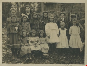
Division II at West Burnaby School
https://search.heritageburnaby.ca/link/museumdescription1354
- Repository
- Burnaby Village Museum
- Date
- [1906 or 1907]
- Collection/Fonds
- Burnaby Village Museum Photograph collection
- Description Level
- Item
- Physical Description
- 1 photograph : sepia postcard ; 7.5 x 13 cm
- Scope and Content
- Photographic postcard of Division II at West Burnaby School (later renamed Kingsway West School) sitting and standing outside. Standing in the back on the far left is John Robertson, fourth from the left is Lillian Bond, beside her is [first name unknown] Barber, Eva Coburne, Mabel Ralph, [first na…
- Repository
- Burnaby Village Museum
- Collection/Fonds
- Burnaby Village Museum Photograph collection
- Description Level
- Item
- Physical Description
- 1 photograph : sepia postcard ; 7.5 x 13 cm
- Scope and Content
- Photographic postcard of Division II at West Burnaby School (later renamed Kingsway West School) sitting and standing outside. Standing in the back on the far left is John Robertson, fourth from the left is Lillian Bond, beside her is [first name unknown] Barber, Eva Coburne, Mabel Ralph, [first name unknown] Bramble, George Robertson, Mabel Rowlinson, unidentified, Georgina Bell, Bright Robertson and Fred Bond. Fourth from the left in the second row is Glen McMaster, sixth is Lois Rumble (later Wilson), beside her is Margaret Creamer, Gladys Bisset, Amy Sandell, unidentified, Elgin Robertson, unidentified and Bill Smith. Sitting in the front row, third from the left is Goldie Ralph, beside her is Edith Marten, unidentified, Jessie Robertson, [first name unknown] McMaster, Grace Marten, Elsie Wilson, Beatrice Barber, Dora Barber, Jean Ross and Dolly Smith. Miss Annie Theresa Forrest is standing on the far left behind her students (next to her is a partially visible bicycle).
- Subjects
- Occupations - Teachers
- Names
- Barber, Dora
- Bell, Georgina
- Bisset, Gladys
- Bond, Fred
- Bond, Lillian
- Coburne, Eva
- Creamer, Margaret
- Forrest, Annie Theresa
- Marten, Edith
- Marten, Grace
- McMaster, Glen
- Ralph, Goldie
- Ralph, Mabel
- Robertson, Bright
- Robertson, Elgin
- Robertson, George
- Robertson, Jessie
- Robertson, John
- Ross, Jean
- Rowlinson, Mabel
- Wilson, Lois Rumble
- Sandell, Amy
- Smith, Bill
- Smith, Dolly
- Wilson, Elsie
- Kingsway West School
- Geographic Access
- Kingsway
- Street Address
- 4800 Kingsway
- Accession Code
- BV999.2.42
- Access Restriction
- No restrictions
- Reproduction Restriction
- May be restricted by third party rights
- Date
- [1906 or 1907]
- Media Type
- Photograph
- Historic Neighbourhood
- Central Park (Historic Neighbourhood)
- Planning Study Area
- Maywood Area
- Related Material
- For another photograph of 2nd Division at West Burnaby School / Kingsway West School, see BV999.2.41
- Scan Resolution
- 600
- Scan Date
- 08-Jun-09
- Scale
- 100
- Photographer
- Barrowclough, George Alfred
- Notes
- Title based on contents of photograph
- Note in black ink on verso of photograph reads: "1907"
- Note in pencil on border on verso of photograph reads: "19 absent."
Images
![Division II at West Burnaby School, [1906 or 1907] thumbnail](/media/hpo/_Data/_BVM_Images/1990/199900020042.jpg)
Division II at West Burnaby School
https://search.heritageburnaby.ca/link/museumdescription4030
- Repository
- Burnaby Village Museum
- Date
- [1906 or 1907]
- Collection/Fonds
- Burnaby Village Museum Photograph collection
- Description Level
- Item
- Physical Description
- 1 photograph : sepia postcard ; 7.5 x 13 cm
- Scope and Content
- Photographic postcard of Division II at West Burnaby School (later renamed Kingsway West School) sitting and standing outside. Standing in the back on the far left is John Robertson, fourth from the left is Lillian Bond, beside her is [first name unknown] Barber, Eva Coburne, Mabel Ralph, [first na…
- Repository
- Burnaby Village Museum
- Collection/Fonds
- Burnaby Village Museum Photograph collection
- Description Level
- Item
- Physical Description
- 1 photograph : sepia postcard ; 7.5 x 13 cm
- Scope and Content
- Photographic postcard of Division II at West Burnaby School (later renamed Kingsway West School) sitting and standing outside. Standing in the back on the far left is John Robertson, fourth from the left is Lillian Bond, beside her is [first name unknown] Barber, Eva Coburne, Mabel Ralph, [first name unknown] Bramble, George Robertson, Mabel Rowlinson, unidentified, Georgina Bell, Bright Robertson and Fred Bond. Fourth from the left in the second row is Glen McMaster, sixth is Lois Rumble (later Wilson), beside her is Margaret Creamer, Gladys Bisset, Amy Sandell, unidentified, Elgin Robertson, unidentified and Bill Smith. Sitting in the front row, third from the left is Goldie Ralph, beside her is Edith Marten, unidentified, Jessie Robertson, [first name unknown] McMaster, Grace Marten, Elsie Wilson, Beatrice Barber, Dora Barber, Jean Ross and Dolly Smith. Miss Annie Theresa Forrest is standing on the far left behind her students (next to her is a partially visible bicycle).
- Subjects
- Occupations - Teachers
- Names
- Barber, Dora
- Bell, Georgina
- Bisset, Gladys
- Bond, Fred
- Bond, Lillian
- Coburne, Eva
- Creamer, Margaret
- Forrest, Annie Theresa
- Marten, Edith
- Marten, Grace
- McMaster, Glen
- Ralph, Goldie
- Ralph, Mabel
- Robertson, Bright
- Robertson, Elgin
- Robertson, George
- Robertson, Jessie
- Robertson, John
- Ross, Jean
- Rowlinson, Mabel
- Wilson, Lois Rumble
- Sandell, Amy
- Smith, Bill
- Smith, Dolly
- Wilson, Elsie
- Kingsway West School
- Geographic Access
- Kingsway
- Street Address
- 4800 Kingsway
- Accession Code
- BV017.8.1
- Access Restriction
- No restrictions
- Reproduction Restriction
- No known restrictions
- Date
- [1906 or 1907]
- Media Type
- Photograph
- Historic Neighbourhood
- Central Park (Historic Neighbourhood)
- Planning Study Area
- Maywood Area
- Related Material
- For another photograph of 2nd Division at West Burnaby School / Kingsway West School, see BV999.2.41
- Notes
- Title based on contents of photograph
- Note in black ink on verso of photograph reads: "1907"
- Note in black ink on border on verso of photograph reads: "19 pupils not here."
- Note in pencil on border on verso of photograph reads: "X 5 4."
- Note in pencil on recto of photograph reads: "47 +19".
- Note in black ink on recto of photograph reads: "Miss A.T. Forrest. / Burnaby.School. / B.C.".
Dundonald School class
https://search.heritageburnaby.ca/link/museumdescription1368
- Repository
- Burnaby Village Museum
- Date
- 1906
- Collection/Fonds
- Burnaby Village Museum Photograph collection
- Description Level
- Item
- Physical Description
- 1 photograph : b&w ; 9 x 12 cm, mounted on card 18 x 23 cm
- Scope and Content
- Photograph of a class of eleven girls and two boys standing outside with their teacher Miss Annie Forrest at the Dundonald School. The students pictured in the photograph are; Maggie Byrne, Annie Thrussell, Nellie Woollard, Gussie Woollard, Elwood Bent and Tommy Brawnlie, Blanche Woollard, [first n…
- Repository
- Burnaby Village Museum
- Collection/Fonds
- Burnaby Village Museum Photograph collection
- Description Level
- Item
- Physical Description
- 1 photograph : b&w ; 9 x 12 cm, mounted on card 18 x 23 cm
- Scope and Content
- Photograph of a class of eleven girls and two boys standing outside with their teacher Miss Annie Forrest at the Dundonald School. The students pictured in the photograph are; Maggie Byrne, Annie Thrussell, Nellie Woollard, Gussie Woollard, Elwood Bent and Tommy Brawnlie, Blanche Woollard, [first name unknown] Brawnlie, Ethel Thrussell, Norah Byrne, Mary Byrne, Bessie Woollard and Alice Woollard. Later called Fraser Arm School, Dundonald School was the fourth school built in Burnaby.
- Subjects
- Occupations - Teachers
- Names
- Dundonald School
- Forrest, Annie Theresa
- Byrne, Margaret "Maggie"
- Thrussell, Annie
- Woollard, Nellie
- Woollard, Gussie
- Bent, Elwood
- Brawnlie, Tommy
- Woollard, Blanche
- Thrussell, Ethel
- Descoteau, Norah Irene Byrne
- Byrne, Mary
- Woollard, Bessie
- Woollard, Alice
- Geographic Access
- Marine Drive
- Street Address
- 5787 Marine Drive
- Accession Code
- BV999.2.58
- Access Restriction
- No restrictions
- Reproduction Restriction
- May be restricted by third party rights
- Date
- 1906
- Media Type
- Photograph
- Historic Neighbourhood
- Fraser Arm (Historic Neighbourhood)
- Planning Study Area
- Clinton-Glenwood Area
- Related Material
- For a copy print from BC archives of the same image, but cropped differently, see HV976.40.3
- Scan Resolution
- 600
- Scan Date
- 08-Jun-09
- Scale
- 100
- Notes
- Title based on contents of photograph
- Note on verso of photograph reads: "Dundonald School. 1906 Left to Right. Maggie Byrne, Annie Thrussell, Nellie Wollard, Gussie Woollard, Elwood Bent, Tommy Brawnlie, Blanche Woollard, Brawnlie, Ethel Thrussell, Nora Byrne, Mary Byrne Bessie Woollard, Alice Woollard."
- Note in pencil on recto of photograph reads: "1906"
Images

Fred K. Leggett family fonds
https://search.heritageburnaby.ca/link/museumdescription18773
- Repository
- Burnaby Village Museum
- Date
- [1900]-1993, predominant [1900-1947]
- Collection/Fonds
- Fred K. Leggett family fonds
- Description Level
- Fonds
- Physical Description
- 16 photographs + 1 videocassette
- Scope and Content
- Fonds consists of a collection of photographs of the Leggett family, the C.W. Parker no. 119 carousel, the Lone Star Circus, a film created by family members that documents the opening day of the C.W. Parker no. 119 carousel at Burnaby Village Museum along with photographs of Parker Carousel "Carry…
- Repository
- Burnaby Village Museum
- Collection/Fonds
- Fred K. Leggett family fonds
- Description Level
- Fonds
- Physical Description
- 16 photographs + 1 videocassette
- Scope and Content
- Fonds consists of a collection of photographs of the Leggett family, the C.W. Parker no. 119 carousel, the Lone Star Circus, a film created by family members that documents the opening day of the C.W. Parker no. 119 carousel at Burnaby Village Museum along with photographs of Parker Carousel "Carry Us All" in Alum Rock San Jose.
- History
- Fred Kirk Leggett was the first owner of the C.W. Parker no. 119 carousel. Fred and Norvie Leggett had six children including, Norvie, Fred D., Leon, Dedie and Ralph. The eldest daughter (name unknown) of F.K. and Norvie Leggett died in 1911. In 1913 the carousel was sold to Fred K. Leggett of Houston Texas for $5,886.00 and was originally equipped with a steam engine and ""wishbones/grass-hopper/jumping horse"" mechanisms. It toured Texas for two years with the Lone Star Circus until 1915 when the machine was shipped back to the factory. It is believed that the machine was rebuilt by the factory with fancier horses and heavier rounding boards referred to as the “Superior” style. Some of the horses were built around 1917 and some between 1920 and 1922. The factory records consulted do not tell for certain where the machine went between 1915 and 1936, possibly to San Jose, California from 1918 until 1922 and then to San Francisco California, or Tacoma, Washington. The carousel was installed at Happyland in the nineteen thirties and then moved to Playland and the PNE. In 1989 "The Lower Mainland Association of Friends of the Vancouver Carousel" came together save the carousel from destruction. With a lot of hard work, the help of the Government of British Columbia and the support of the Municipality of Burnaby, the carousel was purchased. Funds were also raised by The Friends of the Carousel to pay for the restoration, and Burnaby agreed to build a new pavilion for it as a Centennial project. The Centennial Parker Carousel (C.W. Parker no. 119 carousel) and the Don Wrigley Pavilion where the carousel is housed, opened at Burnaby Village Museum on March 25, 1993. The eldest daughter of F.K. Leggett, Norvie Leggett Frame and other members of the Leggett family were in attendance for the opening of the newly restored carousel at Burnaby Village Museum in 1993.
- Responsibility
- Frame, Norvie Leggett
- Accession Code
- BV993.18
- BV993.51
- BV004.94
- BV005.49
- BV005.63
- Date
- [1900]-1993, predominant [1900-1947]
- Media Type
- Photograph
- Moving Images
- Arrangement
- Fonds is arranged by subject from various donations that orignated from the Leggett family.
- Notes
- Title based on contents of fonds
- Contact Burnaby Village Museum to view video content
![Survey and Subdivision plans in New Westminster District Group 2 - Surrey, Delta
, [1898-1910] thumbnail](/media/hpo/_Data/_BVM_Cartographic_Material/1977/1977_0093_0078_001.jpg?width=280)
Survey and Subdivision plans in New Westminster District Group 2 - Surrey, Delta
https://search.heritageburnaby.ca/link/museumdescription7047
- Repository
- Burnaby Village Museum
- Date
- [1898-1910]
- Collection/Fonds
- Burnaby Village Museum Map collection
- Description Level
- File
- Physical Description
- 10 plans : graphite and ink on paper and linen; various sizes mounted on 2 sides of cardboard 76 x 102 cm
- Scope and Content
- File consists of a large board with four plans in New Westminster District mounted on one side and six plans mounted on the other side. Side A: 1. Plan : black ink on paper with colour (no formal title). Plan covers area in New Westminster District, Group 2 situated along the south shore of the …
- Repository
- Burnaby Village Museum
- Collection/Fonds
- Burnaby Village Museum Map collection
- Description Level
- File
- Physical Description
- 10 plans : graphite and ink on paper and linen; various sizes mounted on 2 sides of cardboard 76 x 102 cm
- Material Details
- Scales vary
- Indexed number on tape on edge of board reads "78"
- Scope and Content
- File consists of a large board with four plans in New Westminster District mounted on one side and six plans mounted on the other side. Side A: 1. Plan : black ink on paper with colour (no formal title). Plan covers area in New Westminster District, Group 2 situated along the south shore of the Fraser River identified as "Indian Reserve / Turner 1868" situated in District Lot 1 between District Lot 2 identified as "Mohun's Line" and "Herring's Line" bordered by lots B and A. Includes note "see plan of subdivision of Lots 3 & 4 Gr. 2". (Geographic location: Surrey) 2. Plan : graphite on paper ; Title reads: "B5N R2W, Sec.26_Sec. 28 / Sec. 35_Sec.36". Plan covers a 60 acre parcel in Sec. 35 with Yale wagon road to the south. Scale: 6 chains = 1 inch (Geographic location: Surrey) 3. Plan : black ink on paper ; Title reads: "Survey for Proposed Highway in Indian Reserve Surrey". Plan covers area of land to the northwest of Lot 2 along the shore of the Fraser River and identfies route of proposed highway, proposed tramway as well at the Great Northern Railway and bridge. Scale: 2 chains = 1 inch 4. Plan : black ink on red lined graphing paper ; Title reads: "Sketch Plan Showing Section of Great Northern R. of W. at Point of Crossing of Proposed Ditch". Plan covers area of Lot 2 in New Westminster District, Group 2. (Surrey) Scale: 1 inch = 5 feet. (Geographic location: Surrey) Side B: 1. Plan : black ink on paper ; Title reads: "Plan of Subdivision of a Portion of Section 13, TP2, Surrey Municipality, New Westminster District, B.C.". Plan covers land bordered by Coast Meridian Road (to the east), Bose Road (to the south) and Pike Road (to the west). Surveyed for D.S. Bayners, Nov. 24, 1908. Scale: 5 chains= 1 inch 2. Plan : black ink on linen with colour ; Title reads: "Traverse of the Waterline in front of Lots 3 and 4, Group 2, New Westminster District with G.N. Railway Right of Way". Plan covers area along the southern shore of the Fraser River with a road crossing the Great Northern Railway and leading to a wharf. Scale: 100 feet = 1 inch (Geographic location: Surrey) 3. Plan : black ink on paper ; Title reads: "Survey of the South Boundary of Sec. 12, Township 2, New Westminster District". Plan covers area south of Bose Road and west of Coast Meridean Road and north of McClellen Road. Scale: 400 feet = 1 inch. Sec.12 (Geographic location: Surrey) 4. Plan : graphite on paper ; Title reads: "Plan of Subdivisioin of a part of S.E. 1/4 of Sec. 7, TP 8". Plan covers area of Section 7 in New Westminster District, Group 2, Township 8. Streets are identified running through lot including, Langley Ave., Robinson Ave, Melrose Ave., Hawthorne Ave., Broadway, Bond Ave., Mable Ave., Breene Ave. and McLelland Ave. and Clover Valley Road. Scale: 200 feet = 1 inch. Note in black ink reads: See Bd. 166 for blue print. (Geographic location: Surrey) 5. Plan : graphite on linen ; Title reads: "Sec.20, B5N R2W". Plan covers area north of Yale Road and is subdivided into parts identified as A, B, C, D, E, and unknown. (Geographic location: Surrey) 6. Plan : black ink and graphite on paper ; (no formal title) Plan covers lots surveyed along Ladner Road identified as A, B and Lots 13, 12 and 11. [Geographic location: Delta]
- Accession Code
- HV977.93.78
- Access Restriction
- No restrictions
- Reproduction Restriction
- No known restrictions
- Date
- [1898-1910]
- Media Type
- Cartographic Material
- Scan Resolution
- 600
- Scan Date
- 2023-06-26
- Notes
- Title based on contents of file
- Note re plans 1A & 3A: The sight of Brownsville was also the former site of the Qayqayt First Nation and one of the main summer villages of the Kwantlen and ʷməθkʷəy̓əm (Musqueam) peoples
- Scale is measured in chains and feet. (One chain equals 792 inches)
Zoomable Images
![Survey and Subdivision plans in New Westminster District Group 2 - Surrey, Delta
, [1898-1910] thumbnail](/media/hpo/_Data/_BVM_Cartographic_Material/1977/1977_0093_0078_003_seadragon/1977_0093_0078_003.jpg?w=280)
Survey and Subdivision plans in New Westminster District Group 2 - Surrey, Delta , [1898-1910]
Zoom into Image