Narrow Results By
Subject
- Agriculture - Farms 1
- Buildings - Commercial - Train Stations 1
- Buildings - Recreational 3
- Buildings - Religious - Churches 1
- Buildings - Residential - Houses 3
- Buildings - Schools 2
- Occupations - Farmers 1
- Plants - Trees 2
- Recreational Activities - Golf 3
- Transportation - Electric Railroads 1
- Transportation - Horses 1
- Transportation - Tractors 2
![William Brenchley house, [between 1890 and 1895] (date of original), copied 1985 thumbnail](/media/hpo/_Data/_Archives_Images/_Unrestricted/126/146-001.jpg?width=280)
William Brenchley house
https://search.heritageburnaby.ca/link/archivedescription34863
- Repository
- City of Burnaby Archives
- Date
- [between 1890 and 1895] (date of original), copied 1985
- Collection/Fonds
- Burnaby Historical Society fonds
- Description Level
- Item
- Physical Description
- 1 photograph : b&w ; 8.8 x 12.5 cm print
- Scope and Content
- Photograph of the exterior of the house of William Brenchley at 10th Avenue and Kingsway, northeast corner. A number of people are standing outside. Partially cleared land can be seen in the background.
- Repository
- City of Burnaby Archives
- Date
- [between 1890 and 1895] (date of original), copied 1985
- Collection/Fonds
- Burnaby Historical Society fonds
- Subseries
- W.E. Brenchley subseries
- Physical Description
- 1 photograph : b&w ; 8.8 x 12.5 cm print
- Description Level
- Item
- Record No.
- 146-001
- Access Restriction
- No restrictions
- Reproduction Restriction
- No known restrictions
- Accession Number
- BHS1985-16
- Scope and Content
- Photograph of the exterior of the house of William Brenchley at 10th Avenue and Kingsway, northeast corner. A number of people are standing outside. Partially cleared land can be seen in the background.
- Subjects
- Buildings - Residential - Houses
- Media Type
- Photograph
- Notes
- Title based on contents of photograph
- Geographic Access
- 10th Avenue
- Kingsway
- Historic Neighbourhood
- Edmonds (Historic Neighbourhood)
- Planning Study Area
- Edmonds Area
Images
![William Brenchley house, [between 1890 and 1895] (date of original), copied 1985 thumbnail](/media/hpo/_Data/_Archives_Images/_Unrestricted/126/146-001.jpg)
![William Brenchley farm, [between 1890 and 1895] (date of original), copied 1985 thumbnail](/media/hpo/_Data/_Archives_Images/_Unrestricted/126/146-002.jpg?width=280)
William Brenchley farm
https://search.heritageburnaby.ca/link/archivedescription34864
- Repository
- City of Burnaby Archives
- Date
- [between 1890 and 1895] (date of original), copied 1985
- Collection/Fonds
- Burnaby Historical Society fonds
- Description Level
- Item
- Physical Description
- 1 photograph : b&w ; 8.8 x 12.5 cm print
- Scope and Content
- Photograph of a farm hand and horse team inside a large stump, taken on William Brenchley's farm. The farm was located at the northeast corner of Kingsway and 10th Avenue.
- Repository
- City of Burnaby Archives
- Date
- [between 1890 and 1895] (date of original), copied 1985
- Collection/Fonds
- Burnaby Historical Society fonds
- Subseries
- W.E. Brenchley subseries
- Physical Description
- 1 photograph : b&w ; 8.8 x 12.5 cm print
- Description Level
- Item
- Record No.
- 146-002
- Access Restriction
- No restrictions
- Reproduction Restriction
- No known restrictions
- Accession Number
- BHS1985-16
- Scope and Content
- Photograph of a farm hand and horse team inside a large stump, taken on William Brenchley's farm. The farm was located at the northeast corner of Kingsway and 10th Avenue.
- Media Type
- Photograph
- Photographer
- Thompson, S.J.
- Notes
- Title based on contents of photograph
- Geographic Access
- 10th Avenue
- Kingsway
- Historic Neighbourhood
- Edmonds (Historic Neighbourhood)
- Planning Study Area
- Edmonds Area
Images
![William Brenchley farm, [between 1890 and 1895] (date of original), copied 1985 thumbnail](/media/hpo/_Data/_Archives_Images/_Unrestricted/126/146-002.jpg)
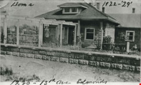
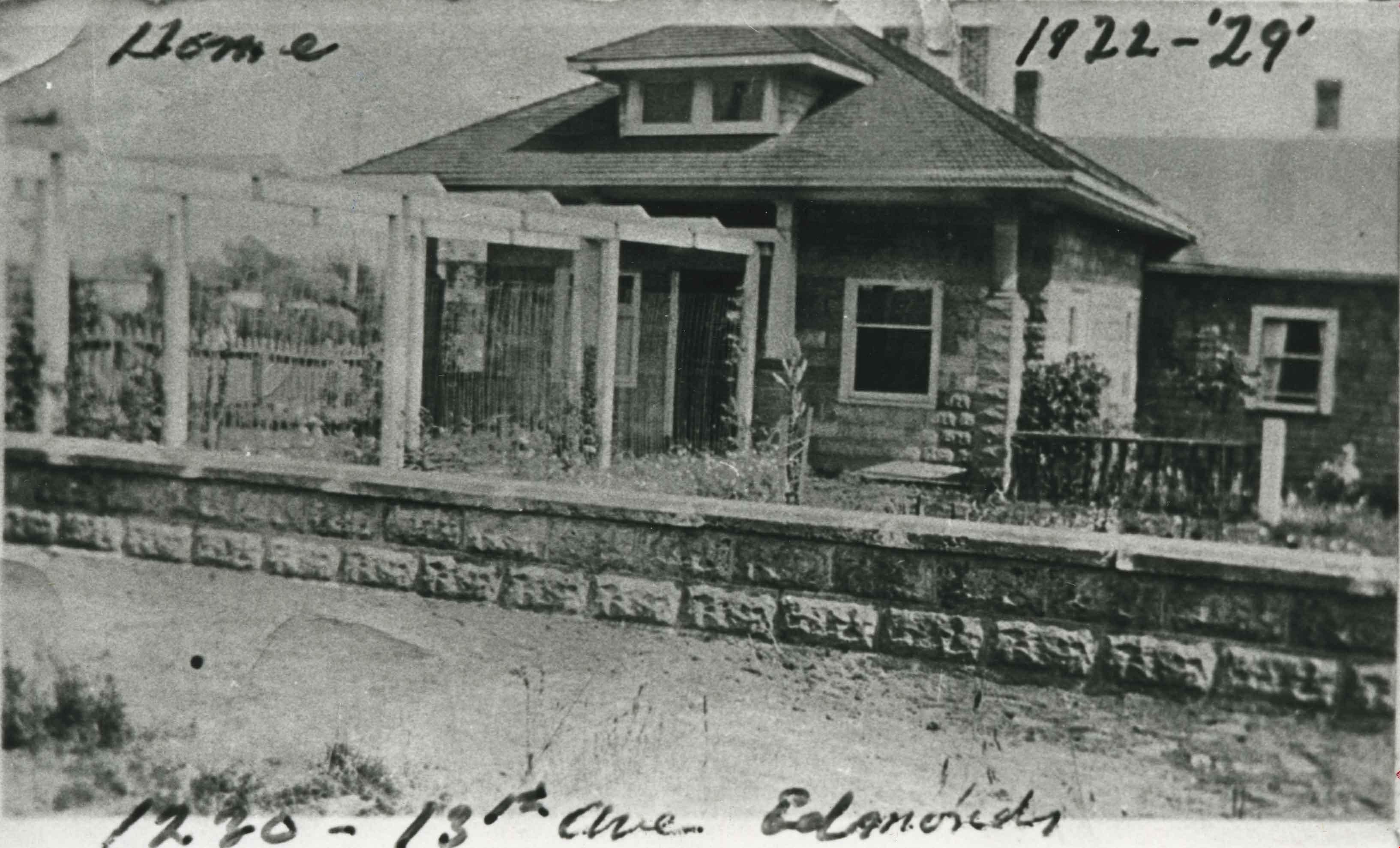
Winch family home
https://search.heritageburnaby.ca/link/archivedescription35714
- Repository
- City of Burnaby Archives
- Date
- 1922 (date of original), copied 1986
- Collection/Fonds
- Burnaby Historical Society fonds
- Description Level
- Item
- Physical Description
- 1 photograph : b&w ; 12.7 x 17.8 cm print
- Scope and Content
- Photograph of the Winch family home, 1230-13th Avenue, East Burnaby. Harold Winch lived here between 1922 and 1929, and Ernie Winch for a longer period. Note the wisteria arbor along the front walk.
- Repository
- City of Burnaby Archives
- Date
- 1922 (date of original), copied 1986
- Collection/Fonds
- Burnaby Historical Society fonds
- Subseries
- Pioneer Tales subseries
- Physical Description
- 1 photograph : b&w ; 12.7 x 17.8 cm print
- Description Level
- Item
- Record No.
- 204-572
- Access Restriction
- No restrictions
- Reproduction Restriction
- No known restrictions
- Accession Number
- BHS1988-03
- Scope and Content
- Photograph of the Winch family home, 1230-13th Avenue, East Burnaby. Harold Winch lived here between 1922 and 1929, and Ernie Winch for a longer period. Note the wisteria arbor along the front walk.
- Subjects
- Buildings - Residential - Houses
- Media Type
- Photograph
- Notes
- Title based on contents of photograph
- Annotations on top and bottom of photograph read, "Home 1922-29" and "1230-13th Ave Edmonds"
- Geographic Access
- 13th Avenue
- Street Address
- 7376 13th Avenue
- Historic Neighbourhood
- Edmonds (Historic Neighbourhood)
- Planning Study Area
- Stride Avenue Area
Images
![Interurban trams, [1930] (date of original), copied 1986 thumbnail](/media/hpo/_Data/_Archives_Images/_Unrestricted/204/204-367.jpg?width=280)
Interurban trams
https://search.heritageburnaby.ca/link/archivedescription35509
- Repository
- City of Burnaby Archives
- Date
- [1930] (date of original), copied 1986
- Collection/Fonds
- Burnaby Historical Society fonds
- Description Level
- Item
- Physical Description
- 1 photograph : b&w ; 12.7 x 17.8 cm print
- Scope and Content
- Photograph of Connaught Hill station on the Central Park Interurban right-of-way at 10th Avenue. To the right, a spur line to the gravel pit used as ballast on tract beds near the Stride garbage dump. The Skytrain maintenance centre was later located there.
- Repository
- City of Burnaby Archives
- Date
- [1930] (date of original), copied 1986
- Collection/Fonds
- Burnaby Historical Society fonds
- Subseries
- Pioneer Tales subseries
- Physical Description
- 1 photograph : b&w ; 12.7 x 17.8 cm print
- Description Level
- Item
- Record No.
- 204-367
- Access Restriction
- No restrictions
- Reproduction Restriction
- No known restrictions
- Accession Number
- BHS1988-03
- Scope and Content
- Photograph of Connaught Hill station on the Central Park Interurban right-of-way at 10th Avenue. To the right, a spur line to the gravel pit used as ballast on tract beds near the Stride garbage dump. The Skytrain maintenance centre was later located there.
- Media Type
- Photograph
- Notes
- Title based on contents of photograph
- Geographic Access
- 10th Avenue
- Central Park Interurban line
- Historic Neighbourhood
- Edmonds (Historic Neighbourhood)
- Planning Study Area
- Edmonds Area
Images
![Interurban trams, [1930] (date of original), copied 1986 thumbnail](/media/hpo/_Data/_Archives_Images/_Unrestricted/204/204-367.jpg)

Silvanovicz family
https://search.heritageburnaby.ca/link/archivedescription36850
- Repository
- City of Burnaby Archives
- Date
- 1934
- Collection/Fonds
- Burnaby Historical Society fonds
- Description Level
- Item
- Physical Description
- 1 photograph : b&w ; 9 x 13 cm print
- Scope and Content
- Photograph of the first Silvanovicz family home at 2109 Willard Street (old street numbering system). Members of the Sivanovicz family are in front, left to right: Helen (daughter), Mary (mother), and Alex (son).
- Repository
- City of Burnaby Archives
- Date
- 1934
- Collection/Fonds
- Burnaby Historical Society fonds
- Subseries
- Burnaby Centennial Anthology subseries
- Physical Description
- 1 photograph : b&w ; 9 x 13 cm print
- Description Level
- Item
- Record No.
- 315-308
- Access Restriction
- No restrictions
- Reproduction Restriction
- No known restrictions
- Accession Number
- BHS1994-04
- Scope and Content
- Photograph of the first Silvanovicz family home at 2109 Willard Street (old street numbering system). Members of the Sivanovicz family are in front, left to right: Helen (daughter), Mary (mother), and Alex (son).
- Media Type
- Photograph
- Notes
- Title based on contents of photograph
- Geographic Access
- Willard Street
- 12th Avenue
- 10th Avenue
- Historic Neighbourhood
- Fraser Arm (Historic Neighbourhood)
- Planning Study Area
- Big Bend Area
Images

![Houses along Tenth Avenue, [1948] (date of original); 2013 (date of duplication) thumbnail](/media/hpo/_Data/_Archives_Images/_Unrestricted/550/557-033.jpg?width=280)
Houses along Tenth Avenue
https://search.heritageburnaby.ca/link/archivedescription78783
- Repository
- City of Burnaby Archives
- Date
- [1948] (date of original); 2013 (date of duplication)
- Collection/Fonds
- Walker family fonds
- Description Level
- Item
- Physical Description
- 1 photograph (jpeg) : b&w ; 96 dpi
- Scope and Content
- Photograph of houses along Tenth Avenue in Burnaby. Visible in front of the houses is a section of the land belonging to Scotty Walker and the Lady of Mercy Brothers.
- Repository
- City of Burnaby Archives
- Date
- [1948] (date of original); 2013 (date of duplication)
- Collection/Fonds
- Walker family fonds
- Physical Description
- 1 photograph (jpeg) : b&w ; 96 dpi
- Description Level
- Item
- Record No.
- 557-033
- Access Restriction
- No restrictions
- Reproduction Restriction
- No known restrictions
- Accession Number
- 2013-15
- Scope and Content
- Photograph of houses along Tenth Avenue in Burnaby. Visible in front of the houses is a section of the land belonging to Scotty Walker and the Lady of Mercy Brothers.
- Subjects
- Buildings - Residential - Houses
- Media Type
- Photograph
- Notes
- Title based on contents of photograph
- Geographic Access
- 10th Avenue
- Historic Neighbourhood
- Edmonds (Historic Neighbourhood)
- Planning Study Area
- Edmonds Area
Images
![Houses along Tenth Avenue, [1948] (date of original); 2013 (date of duplication) thumbnail](/media/hpo/_Data/_Archives_Images/_Unrestricted/550/557-033.jpg)

The Moody Tree
https://search.heritageburnaby.ca/link/archivedescription36085
- Repository
- City of Burnaby Archives
- Date
- 1948
- Collection/Fonds
- Burnaby Historical Society fonds
- Description Level
- Item
- Physical Description
- 1 photograph : b&w ; 17 x 12.5 cm
- Scope and Content
- Photograph of the Moody Tree, a European Ash, which was presented by Colonel Moody to Mr. and Mrs. William Holmes and planted by Mrs. Holmes in the fall of 1861. The home of Mr & Mrs W. Holmes is visible in the background. This tree is on Lot 1, beside the Brunette, at the eastern side of Colby Str…
- Repository
- City of Burnaby Archives
- Date
- 1948
- Collection/Fonds
- Burnaby Historical Society fonds
- Subseries
- Columbian Newspaper subseries
- Physical Description
- 1 photograph : b&w ; 17 x 12.5 cm
- Description Level
- Item
- Record No.
- 222-008
- Access Restriction
- No restrictions
- Reproduction Restriction
- No known restrictions
- Accession Number
- BHS1989-19
- Scope and Content
- Photograph of the Moody Tree, a European Ash, which was presented by Colonel Moody to Mr. and Mrs. William Holmes and planted by Mrs. Holmes in the fall of 1861. The home of Mr & Mrs W. Holmes is visible in the background. This tree is on Lot 1, beside the Brunette, at the eastern side of Colby Street and a few feet from the New Westminister border.
- Subjects
- Plants - Trees
- Media Type
- Photograph
- Notes
- Title based on contents of photograph
- Stamp of copyright on verso of photograph
- Glued to the verso is a photocopy of the photograph with information typed below, identifing the tree as "The Moody Tree"
- Geographic Access
- 10th Avenue
- North Road
- Planning Study Area
- Cariboo-Armstrong Area
Images

![Inter-City Golf Range, [1952] (date of original); 2013 (date of annotation) thumbnail](/media/hpo/_Data/_Archives_Images/_Unrestricted/550/557-035.jpg?width=280)
Inter-City Golf Range
https://search.heritageburnaby.ca/link/archivedescription78785
- Repository
- City of Burnaby Archives
- Date
- [1952] (date of original); 2013 (date of annotation)
- Collection/Fonds
- Walker family fonds
- Description Level
- Item
- Physical Description
- 1 photograph (jpeg) : b&w ; 96 dpi
- Scope and Content
- Photograph of members of the Walker family teeing off at the Inter-City Golf Range annotated with date, title and identification key.
- Repository
- City of Burnaby Archives
- Date
- [1952] (date of original); 2013 (date of annotation)
- Collection/Fonds
- Walker family fonds
- Physical Description
- 1 photograph (jpeg) : b&w ; 96 dpi
- Description Level
- Item
- Record No.
- 557-035
- Access Restriction
- No restrictions
- Reproduction Restriction
- No known restrictions
- Accession Number
- 2013-15
- Scope and Content
- Photograph of members of the Walker family teeing off at the Inter-City Golf Range annotated with date, title and identification key.
- Media Type
- Photograph
- Notes
- Transcribed title
- Geographic Access
- 10th Avenue
- Historic Neighbourhood
- Edmonds (Historic Neighbourhood)
- Planning Study Area
- Edmonds Area
Images
![Inter-City Golf Range, [1952] (date of original); 2013 (date of annotation) thumbnail](/media/hpo/_Data/_Archives_Images/_Unrestricted/550/557-035.jpg)
![Inter-City Golf Driving Range clubhouse, [1954] (date of original); 2013 (date of duplication) thumbnail](/media/hpo/_Data/_Archives_Images/_Unrestricted/550/557-024.jpg?width=280)
Inter-City Golf Driving Range clubhouse
https://search.heritageburnaby.ca/link/archivedescription78773
- Repository
- City of Burnaby Archives
- Date
- [1954] (date of original); 2013 (date of duplication)
- Collection/Fonds
- Walker family fonds
- Description Level
- Item
- Physical Description
- 1 photograph (jpeg) : b&w ; 300 dpi
- Scope and Content
- Photograph of a tractor attempting to move the Inter-City Golf Driving Range's clubhouse.
- Repository
- City of Burnaby Archives
- Date
- [1954] (date of original); 2013 (date of duplication)
- Collection/Fonds
- Walker family fonds
- Physical Description
- 1 photograph (jpeg) : b&w ; 300 dpi
- Description Level
- Item
- Record No.
- 557-024
- Access Restriction
- No restrictions
- Reproduction Restriction
- No known restrictions
- Accession Number
- 2013-15
- Scope and Content
- Photograph of a tractor attempting to move the Inter-City Golf Driving Range's clubhouse.
- Media Type
- Photograph
- Notes
- Title based on contents of photograph
- Geographic Access
- 10th Avenue
- Historic Neighbourhood
- Edmonds (Historic Neighbourhood)
- Planning Study Area
- Edmonds Area
Images
![Inter-City Golf Driving Range clubhouse, [1954] (date of original); 2013 (date of duplication) thumbnail](/media/hpo/_Data/_Archives_Images/_Unrestricted/550/557-024.jpg)
![Inter-City Golf Driving Range clubhouse, [1954] (date of original); 2013 (date of duplication) thumbnail](/media/hpo/_Data/_Archives_Images/_Unrestricted/550/557-025.jpg?width=280)
Inter-City Golf Driving Range clubhouse
https://search.heritageburnaby.ca/link/archivedescription78774
- Repository
- City of Burnaby Archives
- Date
- [1954] (date of original); 2013 (date of duplication)
- Collection/Fonds
- Walker family fonds
- Description Level
- Item
- Physical Description
- 1 photograph (jpeg) : b&w ; 300 dpi
- Scope and Content
- Photograph of a tractor attempting to move the Inter-City Golf Driving Range's clubhouse.
- Repository
- City of Burnaby Archives
- Date
- [1954] (date of original); 2013 (date of duplication)
- Collection/Fonds
- Walker family fonds
- Physical Description
- 1 photograph (jpeg) : b&w ; 300 dpi
- Description Level
- Item
- Record No.
- 557-025
- Access Restriction
- No restrictions
- Reproduction Restriction
- No known restrictions
- Accession Number
- 2013-15
- Scope and Content
- Photograph of a tractor attempting to move the Inter-City Golf Driving Range's clubhouse.
- Media Type
- Photograph
- Notes
- Title based on contents of photograph
- Geographic Access
- 10th Avenue
- Historic Neighbourhood
- Edmonds (Historic Neighbourhood)
- Planning Study Area
- Edmonds Area
Images
![Inter-City Golf Driving Range clubhouse, [1954] (date of original); 2013 (date of duplication) thumbnail](/media/hpo/_Data/_Archives_Images/_Unrestricted/550/557-025.jpg)

Running track at Saint Thomas More Collegiate
https://search.heritageburnaby.ca/link/archivedescription78788
- Repository
- City of Burnaby Archives
- Date
- 2001 (date of original); 2013 (date of annotation)
- Collection/Fonds
- Walker family fonds
- Description Level
- Item
- Physical Description
- 1 photograph (jpeg) : col. ; 300 dpi
- Scope and Content
- Photograph of the running track at Saint Thomas More Collegiate with Our Lady of Mercy Parish visible in the background.
- Repository
- City of Burnaby Archives
- Date
- 2001 (date of original); 2013 (date of annotation)
- Collection/Fonds
- Walker family fonds
- Physical Description
- 1 photograph (jpeg) : col. ; 300 dpi
- Description Level
- Item
- Record No.
- 557-038
- Access Restriction
- No restrictions
- Reproduction Restriction
- No known restrictions
- Accession Number
- 2013-15
- Scope and Content
- Photograph of the running track at Saint Thomas More Collegiate with Our Lady of Mercy Parish visible in the background.
- Subjects
- Buildings - Religious - Churches
- Media Type
- Photograph
- Notes
- Title based on contents of photograph
- Geographic Access
- 10th Avenue
- Historic Neighbourhood
- Edmonds (Historic Neighbourhood)
- Planning Study Area
- Edmonds Area
Images


Running track at Saint Thomas More Collegiate
https://search.heritageburnaby.ca/link/archivedescription78789
- Repository
- City of Burnaby Archives
- Date
- 2001 (date of original); 2013 (date of annotation)
- Collection/Fonds
- Walker family fonds
- Description Level
- Item
- Physical Description
- 1 photograph (jpeg) : col. ; 300 dpi
- Scope and Content
- Photograph of the running track at Saint Thomas More Collegiate with the school visible in the background.
- Repository
- City of Burnaby Archives
- Date
- 2001 (date of original); 2013 (date of annotation)
- Collection/Fonds
- Walker family fonds
- Physical Description
- 1 photograph (jpeg) : col. ; 300 dpi
- Description Level
- Item
- Record No.
- 557-039
- Access Restriction
- No restrictions
- Reproduction Restriction
- No known restrictions
- Accession Number
- 2013-15
- Scope and Content
- Photograph of the running track at Saint Thomas More Collegiate with the school visible in the background.
- Subjects
- Buildings - Schools
- Media Type
- Photograph
- Notes
- Title based on contents of photograph
- Geographic Access
- 10th Avenue
- Historic Neighbourhood
- Edmonds (Historic Neighbourhood)
- Planning Study Area
- Edmonds Area
Images


Running track at Saint Thomas More Collegiate
https://search.heritageburnaby.ca/link/archivedescription78790
- Repository
- City of Burnaby Archives
- Date
- 2001 (date of original); 2013 (date of annotation)
- Collection/Fonds
- Walker family fonds
- Description Level
- Item
- Physical Description
- 1 photograph (jpeg) : col. ; 96 dpi
- Scope and Content
- Photograph of the running track at Saint Thomas More Collegiate with the school visible in the background.
- Repository
- City of Burnaby Archives
- Date
- 2001 (date of original); 2013 (date of annotation)
- Collection/Fonds
- Walker family fonds
- Physical Description
- 1 photograph (jpeg) : col. ; 96 dpi
- Description Level
- Item
- Record No.
- 557-040
- Access Restriction
- No restrictions
- Reproduction Restriction
- No known restrictions
- Accession Number
- 2013-15
- Scope and Content
- Photograph of the running track at Saint Thomas More Collegiate with the school visible in the background.
- Subjects
- Buildings - Schools
- Media Type
- Photograph
- Notes
- Title based on contents of photograph
- Geographic Access
- 10th Avenue
- Historic Neighbourhood
- Edmonds (Historic Neighbourhood)
- Planning Study Area
- Edmonds Area
Images
