Narrow Results By

Bird's Eye View of the Burnaby Lake Area
https://search.heritageburnaby.ca/link/museumdescription15144
- Repository
- Burnaby Village Museum
- Date
- 1977
- Collection/Fonds
- Century Park Museum Association fonds
- Description Level
- Item
- Physical Description
- 1 map : b&w print on paper ; 43 x 63.5 cm
- Scope and Content
- Item consists of a map titled "Birds Eye View of the Burnaby Lake Area Circa 1910". The overview of the Burnaby Lake area was compiled and drawn at Heritage Village by curator John Adams and artist, Carol Swan. The map identifies the Burnaby Lake inter-urban tram line; roads including: Sperling Ave…
- Repository
- Burnaby Village Museum
- Collection/Fonds
- Century Park Museum Association fonds
- Description Level
- Item
- Physical Description
- 1 map : b&w print on paper ; 43 x 63.5 cm
- Material Details
- Scale indeterminable
- Scope and Content
- Item consists of a map titled "Birds Eye View of the Burnaby Lake Area Circa 1910". The overview of the Burnaby Lake area was compiled and drawn at Heritage Village by curator John Adams and artist, Carol Swan. The map identifies the Burnaby Lake inter-urban tram line; roads including: Sperling Avenue (Pole Line Road); Gilpin Avenue; Douglas Road; trail to Vancouver Westminster Road (Kingsway); Buckingham Avenue; Haszard Street; various farms and residences including: Charles Sprott "Norland"; H.T. Ceperley "Fairacres"; Claude Hill's "Brookfield farm" and "Broadview"; F.J. Hart's "Avalon"; Miss Woodward's former and new home, school and post office; Councillor Edgar's hunting cabin; Edgar Sprott's "Mayfield farm" and "Mayfield Lodge"; F.J. Peers "Greyfriars"; Arthur de Windt Haszard; Bernard Hill's boathouse as well as other landmarks including: Doran's Mill; tram stations; Burnaby Lake Store; logging camps; wood cutter's shacks; ice houses; cranberry bog; Still Creek; Deer Lake; Burnaby Lake; Deer Lake Creek; Provincial Government Reserve Proposed Hospital (later Oakalla Prison).
- Creator
- Adams, John
- Swan, Carol
- Names
- Hill, Arthur Claude
- Sprott, Charles Frederick
- Sprott, Louis "Edgar"
- Hart, Frederick John, 1884-1945
- Ceperley, H.T.
- Woodward, Maude
- Woodward, Harriet
- Peers, Francis J.
- Haszard, Arthur de Windt
- Hill, Bernard R.
- Geographic Access
- Deer Lake Avenue
- Sperling Avenue
- Haszard Street
- Buckingham Avenue
- Accession Code
- BV021.1.3
- Access Restriction
- No restrictions
- Reproduction Restriction
- No known restrictions
- Date
- 1977
- Media Type
- Cartographic Material
- Historic Neighbourhood
- Burnaby Lake (Historic Neighbourhood)
- Planning Study Area
- Burnaby Lake Area
- Related Material
- See also: Life with the Moores of Hart House : pioneer days on Burnaby's Deer Lake
- Scan Resolution
- 600
- Scan Date
- 2021-11-12
- Scale
- 100
- Notes
- Transcribed title
- Compiled by John Adams; illustration by Carol Swan
- The map depicts the Burnaby Lake Tram Line as being double tracked, whereas in reality it was single tracked.
- Map is part of the book "Life with the Moores of Hart House : pioneer days on Burnaby's Deer Lake https://search.heritageburnaby.ca/permalink/museumlibrary6314-102
Images


Bird's Eye View of the Burnaby Lake Area
https://search.heritageburnaby.ca/link/museumdescription17543
- Repository
- Burnaby Village Museum
- Date
- 1977
- Collection/Fonds
- Century Park Museum Association fonds
- Description Level
- Item
- Physical Description
- 1 map : b&w print with watercolour ; 43 x 63.5 cm
- Scope and Content
- Item consists of a map titled "Birds Eye View of the Burnaby Lake Area Circa 1910". The overview of the Burnaby Lake area was compiled and drawn at Heritage Village by curator John Adams and artist, Carol Swan. The map identifies the Burnaby Lake inter-urban tram line; roads including: Sperling Ave…
- Repository
- Burnaby Village Museum
- Collection/Fonds
- Century Park Museum Association fonds
- Description Level
- Item
- Physical Description
- 1 map : b&w print with watercolour ; 43 x 63.5 cm
- Material Details
- Scale indeterminable
- Scope and Content
- Item consists of a map titled "Birds Eye View of the Burnaby Lake Area Circa 1910". The overview of the Burnaby Lake area was compiled and drawn at Heritage Village by curator John Adams and artist, Carol Swan. The map identifies the Burnaby Lake inter-urban tram line; roads including: Sperling Avenue (Pole Line Road); Gilpin Avenue; Douglas Road; trail to Vancouver Westminster Road (Kingsway); Buckingham Avenue; Haszard Street; various farms and residences including: Charles Sprott "Norland"; H.T. Ceperley "Fairacres"; Claude Hill's "Brookfield farm" and "Broadview"; F.J. Hart's "Avalon"; Miss Woodward's former and new home, school and post office; Councillor Edgar's hunting cabin; Edgar Sprott's "Mayfield farm" and "Mayfield Lodge"; F.J. Peers "Greyfriars"; Arthur de Windt Haszard; Bernard Hill's boathouse as well as other landmarks including: Doran's Mill; tram stations; Burnaby Lake Store; logging camps; wood cutter's shacks; ice houses; cranberry bog; Still Creek; Deer Lake; Burnaby Lake; Deer Lake Creek; Provincial Government Reserve Proposed Hospital (later Oakalla Prison).
- Creator
- Adams, John
- Swan, Carol
- Names
- Hill, Arthur Claude
- Sprott, Charles Frederick
- Sprott, Louis "Edgar"
- Hart, Frederick John, 1884-1945
- Ceperley, H.T.
- Woodward, Maude
- Woodward, Harriet
- Peers, Francis J.
- Haszard, Arthur de Windt
- Hill, Bernard R.
- Geographic Access
- Deer Lake Avenue
- Sperling Avenue
- Haszard Street
- Buckingham Avenue
- Accession Code
- BV021.1.4
- Access Restriction
- No restrictions
- Reproduction Restriction
- No known restrictions
- Date
- 1977
- Media Type
- Cartographic Material
- Historic Neighbourhood
- Burnaby Lake (Historic Neighbourhood)
- Planning Study Area
- Burnaby Lake Area
- Related Material
- See also: Life with the Moores of Hart House : pioneer days on Burnaby's Deer Lake
- Scan Resolution
- 600
- Scan Date
- 2021-11-12
- Scale
- 100
- Notes
- Transcribed title
- Compiled by John Adams; illustration by Carol Swan
- The map depicts the Burnaby Lake Tram Line as being double tracked, whereas in reality it was single tracked.
- Map is part of the book "Life with the Moores of Hart House : pioneer days on Burnaby's Deer Lake https://search.heritageburnaby.ca/permalink/museumlibrary6314-102
- This is a print made from original illustration and appears to be hand-coloured with watercolour at a later date.
Images

![Burnaby Lake School, [1925] thumbnail](/media/hpo/_Data/_Archives_Images/_Unrestricted/477/477-458.jpg?width=280)
Burnaby Lake School
https://search.heritageburnaby.ca/link/archivedescription39139
- Repository
- City of Burnaby Archives
- Date
- [1925]
- Collection/Fonds
- Peers Family and Hill Family fonds
- Description Level
- Item
- Physical Description
- 1 photograph : b&w ; 7.5 x 12 cm on page 24.5 x 32.5 cm (pasted in album)
- Scope and Content
- Photograph of students at "Miss Harry's" private school at Burnaby Lake. Harriet Woodward and her sister, Maude, ran a school and a post office out of their home for many years and were early residents of the area. Identified in the photograph are: Harriet Woodward who is standing to the far right…
- Repository
- City of Burnaby Archives
- Date
- [1925]
- Collection/Fonds
- Peers Family and Hill Family fonds
- Physical Description
- 1 photograph : b&w ; 7.5 x 12 cm on page 24.5 x 32.5 cm (pasted in album)
- Description Level
- Item
- Record No.
- 477-458
- Access Restriction
- No restrictions
- Reproduction Restriction
- No known restrictions
- Accession Number
- 2007-12
- Scope and Content
- Photograph of students at "Miss Harry's" private school at Burnaby Lake. Harriet Woodward and her sister, Maude, ran a school and a post office out of their home for many years and were early residents of the area. Identified in the photograph are: Harriet Woodward who is standing to the far right at the top of the stairs (with white shirt), her mother Julia Woodward beside her (with black shirt) and her sister Maude Woodward, standing to the far left (with striped shirt). In the second row standing first on the left is Molly Lamb Boback. The rest are unidentified.
- Media Type
- Photograph
- Notes
- Title based on contents of photograph
- Geographic Access
- Sperling Avenue
- Street Address
- 5195 Sperling Avenue
- Historic Neighbourhood
- Burnaby Lake (Historic Neighbourhood)
- Planning Study Area
- Morley-Buckingham Area
Images
![Burnaby Lake School, [1925] thumbnail](/media/hpo/_Data/_Archives_Images/_Unrestricted/477/477-458.jpg)

First School at Burnaby Lake
https://search.heritageburnaby.ca/link/archivedescription39549
- Repository
- City of Burnaby Archives
- Date
- 1909
- Collection/Fonds
- Peers Family and Hill Family fonds
- Description Level
- Item
- Physical Description
- 1 photograph : b&w ; 12.5 x 17 cm on page 21.5 x 28 cm (pasted in album)
- Scope and Content
- Photograph of Harriet Woodward and her class of students outside the Woodward home near Deer Lake which served as the first school and post office in the Burnaby Lake area; (l to r): Harriet Woodward (Miss Harry), Bob Peers, Melvin Mawhinney, Muriel Sprott, Kitty Hill, Beatrice Clayton and Arthur P…
- Repository
- City of Burnaby Archives
- Date
- 1909
- Collection/Fonds
- Peers Family and Hill Family fonds
- Physical Description
- 1 photograph : b&w ; 12.5 x 17 cm on page 21.5 x 28 cm (pasted in album)
- Description Level
- Item
- Record No.
- 477-868
- Access Restriction
- No restrictions
- Reproduction Restriction
- No known restrictions
- Accession Number
- 2007-12
- Scope and Content
- Photograph of Harriet Woodward and her class of students outside the Woodward home near Deer Lake which served as the first school and post office in the Burnaby Lake area; (l to r): Harriet Woodward (Miss Harry), Bob Peers, Melvin Mawhinney, Muriel Sprott, Kitty Hill, Beatrice Clayton and Arthur Peers. The cottage was a prefabricated building designed by J.J. Mahoney and architect Joseph Bowman and was manufactured in Vancouver by the B.C. Mills Timber and Trading Company and erected here is 1904. The cottage was enlarged with several additions until 1912 when the Woodwards built a new house.
- Subjects
- Buildings - Residential - Houses
- Buildings - Public - Post Offices
- Buildings - Schools
- Occupations - Teachers
- Names
- Clayton, Beatrice
- Mawhinney, Melvin
- Peers, Arthur Francis "Mike"
- Peers, Katherine Maude Hill "Kitty"
- Peers, William John "Bob"
- Sprott, Muriel
- Woodward, Harriet
- Media Type
- Photograph
- Notes
- Title based on caption accompanying photograph
- Geographic Access
- Sperling Avenue
- Street Address
- 5141 Sperling Avenue
- Historic Neighbourhood
- Burnaby Lake (Historic Neighbourhood)
- Planning Study Area
- Morley-Buckingham Area
Images

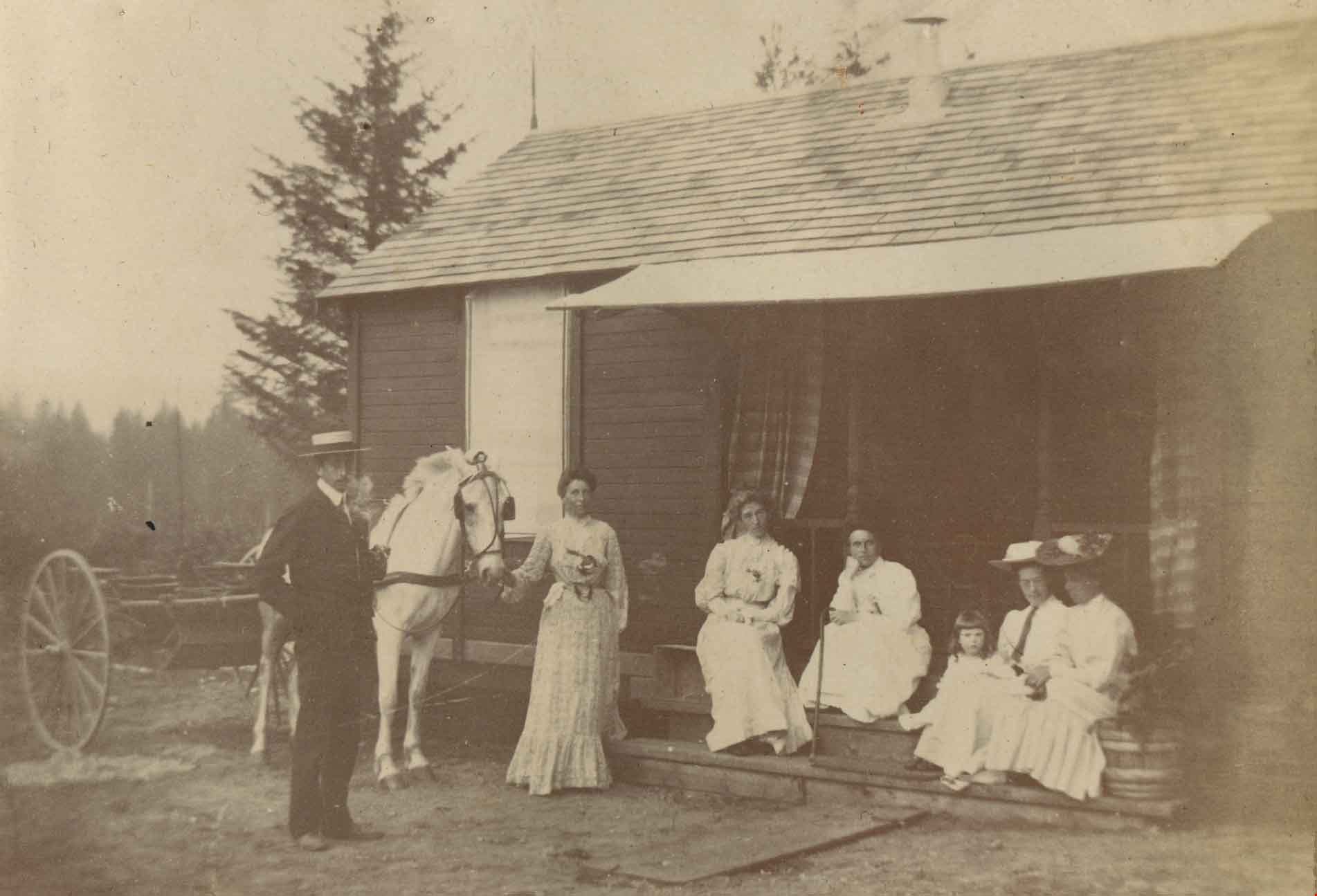
Maude and Harriet Woodward's cottage
https://search.heritageburnaby.ca/link/archivedescription39570
- Repository
- City of Burnaby Archives
- Date
- 1906
- Collection/Fonds
- Peers Family and Hill Family fonds
- Description Level
- Item
- Physical Description
- 1 photograph : b&w ; 5.2 x 8.2 cm on page 21.5 x 28 cm (pasted in album)
- Scope and Content
- Photograph of a group of people in front of Maude and Harriet Woodward's cottage. This house was a prefabricated cottage erected in 1904. The cottages were designed by J.J. Mahoney and architect Joseph Bowman and were manufactured in Vancouver by the B.C. Mills Timber and Trading Company. Maude Wo…
- Repository
- City of Burnaby Archives
- Date
- 1906
- Collection/Fonds
- Peers Family and Hill Family fonds
- Physical Description
- 1 photograph : b&w ; 5.2 x 8.2 cm on page 21.5 x 28 cm (pasted in album)
- Description Level
- Item
- Record No.
- 477-889
- Access Restriction
- No restrictions
- Reproduction Restriction
- No known restrictions
- Accession Number
- 2007-12
- Scope and Content
- Photograph of a group of people in front of Maude and Harriet Woodward's cottage. This house was a prefabricated cottage erected in 1904. The cottages were designed by J.J. Mahoney and architect Joseph Bowman and were manufactured in Vancouver by the B.C. Mills Timber and Trading Company. Maude Woodward established a post-office here which was operated by her sister, Harriet. Harriet also began a small private school here, the first in Burnaby Lake. The cottage was enlarged with several additions until 1912 when the Woodwards built a new house. Shown here are (l t r): Charles Frederick Sprott, Frances Schou, Lucy Christine Sprott (nee Schou), Harriet Woodward, Kitty Hill, Maude Woodward and Annie Hill.
- Subjects
- Buildings - Residential - Cabins
- Transportation - Horses
- Transportation - Wagons
- Occupations - Teachers
- Officials - Mayors and Reeves
- Names
- Hill, Annie Sara Kenrick
- Peers, Katherine Maude Hill "Kitty"
- Schou, Frances
- Sprott, Lucy Christine Schou
- Sprott, Charles Frederick
- Woodward, Harriet
- Woodward, Maude
- Media Type
- Photograph
- Notes
- Title based on contents of photograph
- Geographic Access
- Sperling Avenue
- Street Address
- 5141 Sperling Avenue
- Historic Neighbourhood
- Burnaby Lake (Historic Neighbourhood)
- Planning Study Area
- Morley-Buckingham Area
Images

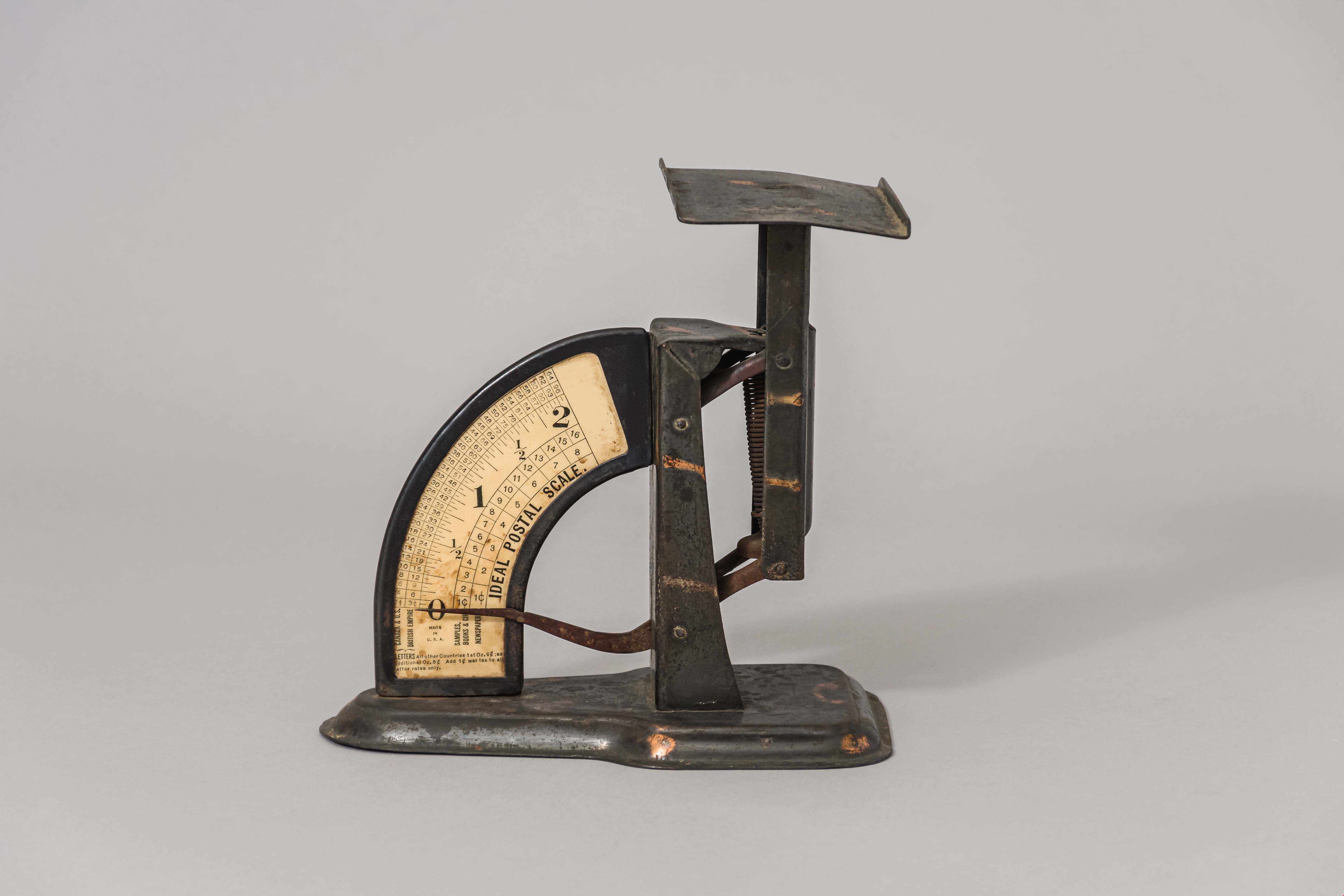
postal scale
https://search.heritageburnaby.ca/link/museumartifact15965
- Repository
- Burnaby Village Museum
- Accession Code
- HV983.61.3
- Description
- Postal scale, "IDEAL POSTAL SCALE"
- Object History
- Postal scale used by Harriet Woodward at the Burnaby Lake Post Office. The Burnaby Lake Post Office was run out of the Woodward cottage, owned by Harriet and Maude Woodward. The cottage was a prefabricated cottage erected in 1904. Harriet also began a small private school in the cottage, the first in Burnaby Lake. The cottage was enlarged with several additions until 1912 when the Woodwards built a new house.
- Classification
- Weights and Measurements Tools and Equipment - Scales
- Object Term
- Scale, Postal
- Geographic Access
- Sperling Avenue
- Street Address
- 5141 Sperling Avenue
- Historic Neighbourhood
- Burnaby Lake (Historic Neighbourhood)
- Planning Study Area
- Morley-Buckingham Area
Images