Narrow Results By
Subject
- Advertising Medium - Signs and Signboards 6
- Aerial Photographs 1
- Agriculture - Farms 2
- Agriculture - Fruit and Berries 2
- Animals - Cows 1
- Animals - Dogs 3
- Animals - Goats 2
- Animals - Poultry 3
- Building Components 8
- Buildings - Agricultural 1
- Buildings - Agricultural - Barns 1
- Buildings - Agricultural - Greenhouses 2
Creator
- Bartel, Mario 4
- Bellinger, Bernard 11
- Bowman & Cullerne 1
- British Columbia Underwriters' Association 3
- Chapman, Fred 1
- Cheung, Nakita 3
- Dominion Photo Company 1
- Henderson, Norman M. "Norm" 1
- McCarron, John 5
- Norton, Paul 10
- Plan Department, British Columbia Insurance Underwriters' Association 3
- Printed on back of postcard: "Pub. by Living Colour Advertising Agencies, 809 21st St., New West'r, BC - 526-6612" and "Made in Canada / Dexter Color, Canada Ltd., Cornwall, Ontario" 1
Tile
https://search.heritageburnaby.ca/link/museumartifact90826
- Repository
- Burnaby Village Museum
- Accession Code
- BV020.40.17
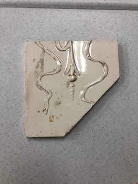
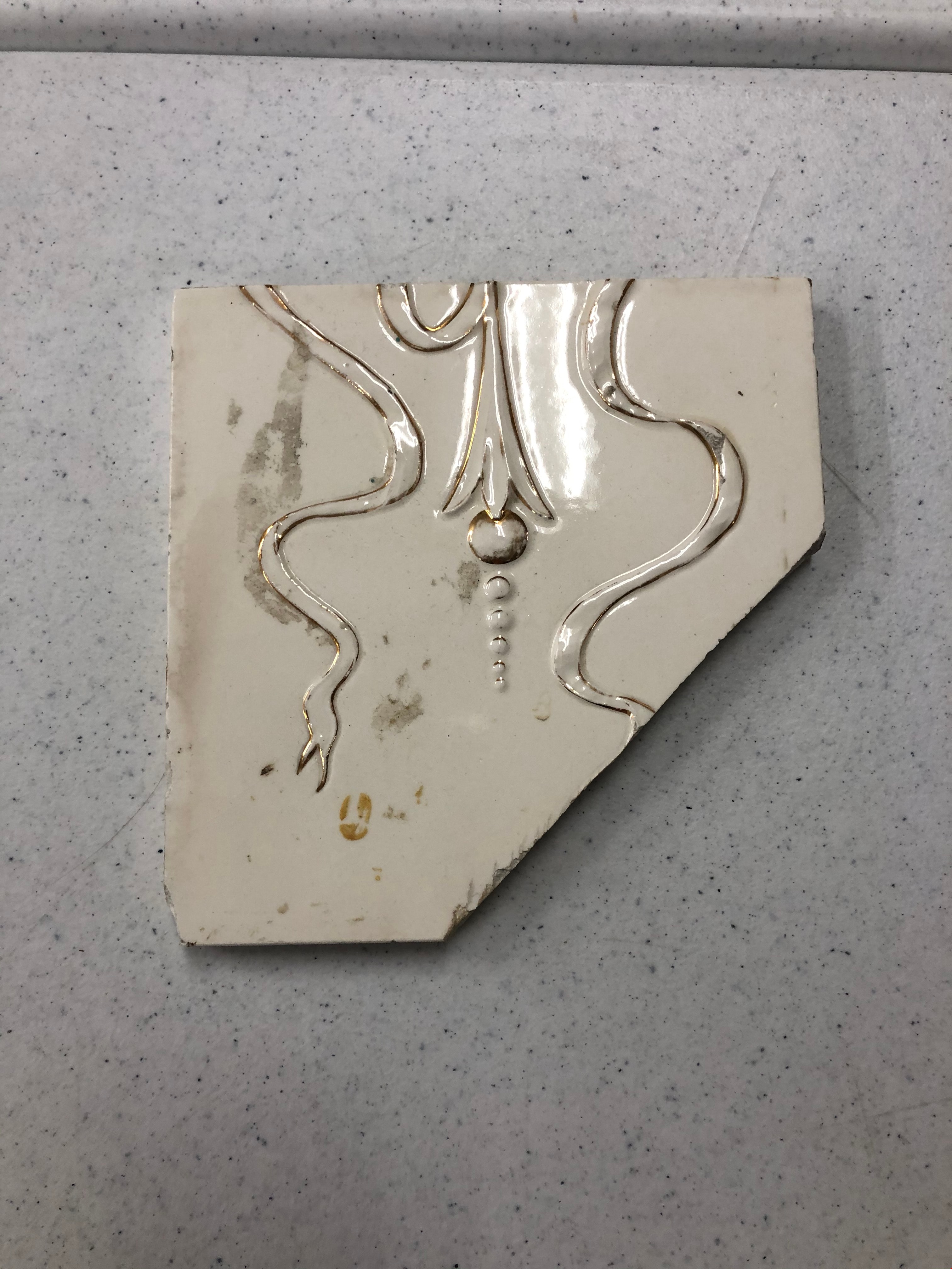
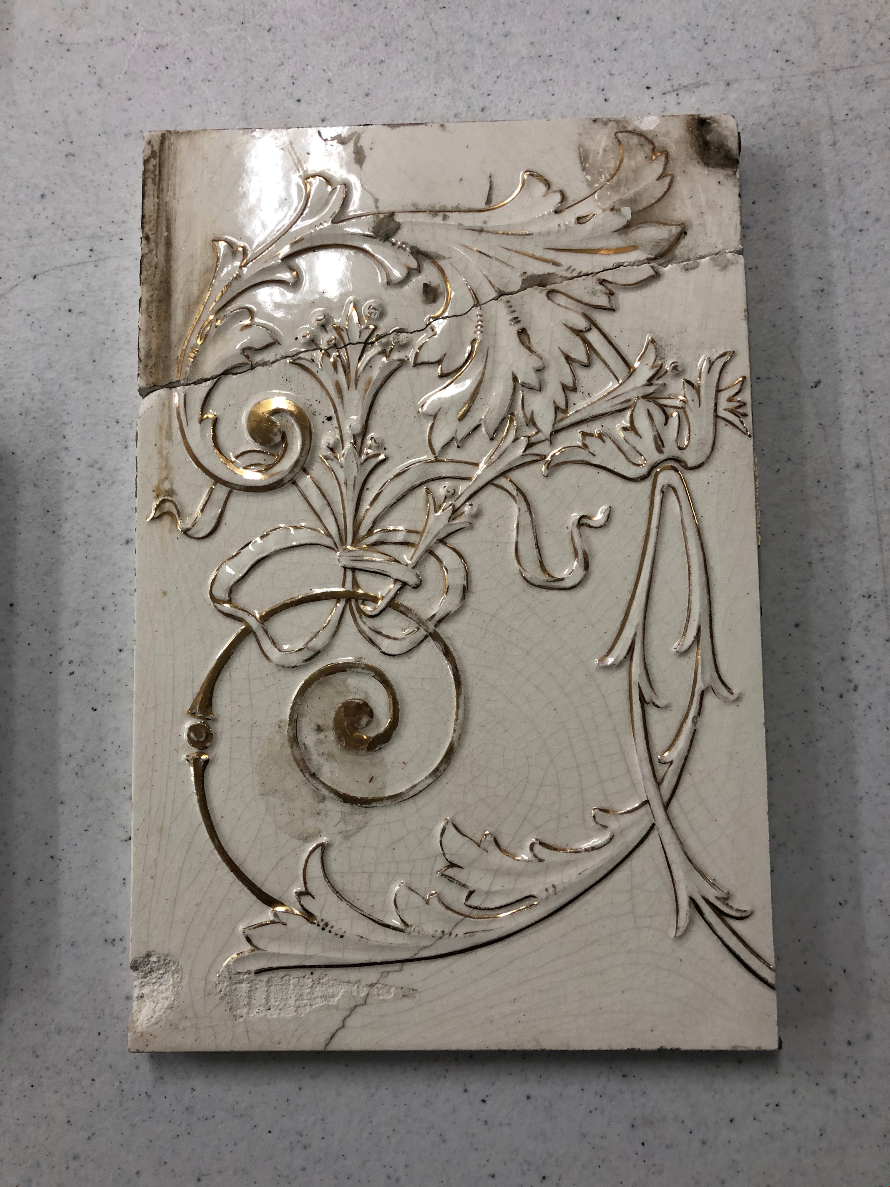
- Description
- White ceramic tile with gold design. The design is made up of a gold flower hanging down the centre with six circles coming from the opening of the bell shape. There are two tendrils of ribbon framing either side of the flower in an "S" shape. One end of the ribbon is cut like the end of a snake's tongue. There is a clean diagonal break, nearly a quarter of the whole tile.
- Object History
- These tiles are from Glenedward Mansion, built in 1912. It was built at 3412 Kingsway, which later became 5152 Kingsway. They were salvaged when the mansion was demolished in the 1990s.
- Category
- 01. Built Environment Objects
- Classification
- Building Components - - Surface Elements
- Object Term
- Tile, Decorative
- Measurements
- 6" x 6"
- Subjects
- Building Components
- Buildings - Heritage
- Historic Neighbourhood
- Edmonds (Historic Neighbourhood)
- Planning Study Area
- Windsor Area
Images
Tile
https://search.heritageburnaby.ca/link/museumartifact90827
- Repository
- Burnaby Village Museum
- Accession Code
- BV020.40.18
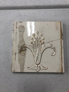
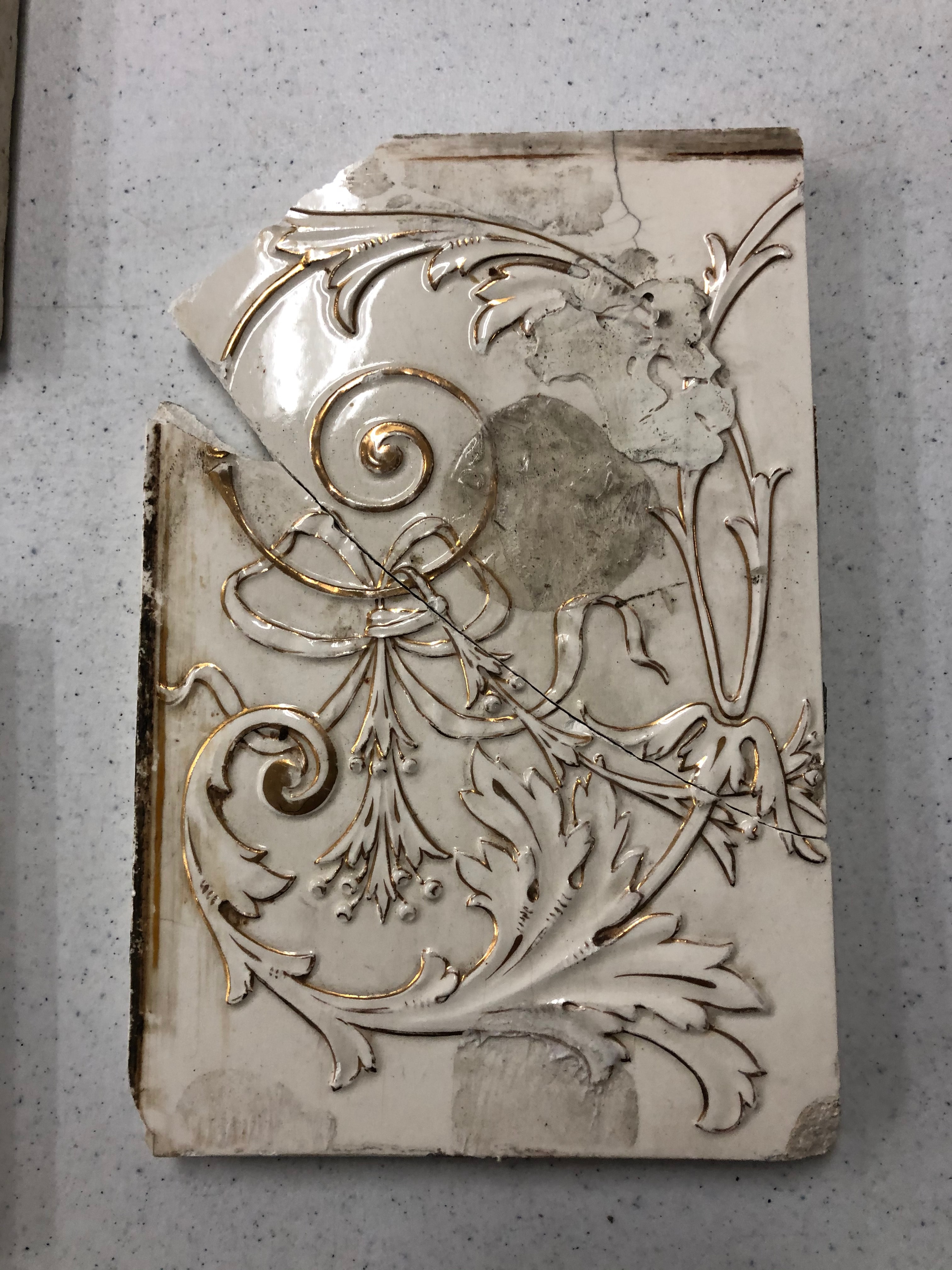
- Description
- White ceramic tile with gold design. The design is made up of one flower with two petals curled and splaying out to the right and left side, with two smaller petals in the centre. The flower is resting on a decorative leaf design at the base of the tile. Thirteen stamens with round tips are coming out of the flower. There is a brown stain down the left hands side. There is a clean diagonal break through the middle of the tile.
- Object History
- These tiles are from Glenedward Mansion, built in 1912. It was built at 3412 Kingsway, which later became 5152 Kingsway. They were salvaged when the mansion was demolished in the 1990s.
- Category
- 01. Built Environment Objects
- Classification
- Building Components - - Surface Elements
- Object Term
- Tile, Decorative
- Colour
- White
- Gold
- Measurements
- 6" x 6"
- Subjects
- Building Components
- Buildings - Heritage
- Historic Neighbourhood
- Edmonds (Historic Neighbourhood)
- Planning Study Area
- Windsor Area
Images

Tile
https://search.heritageburnaby.ca/link/museumartifact90830
- Repository
- Burnaby Village Museum
- Accession Code
- BV020.40.19
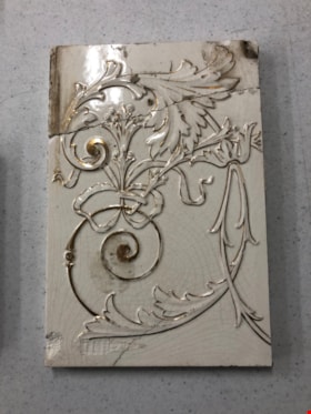
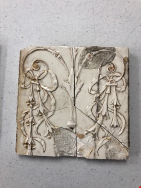
- Description
- White ceramic tile with gold design. The design is made up of two flowers attached to a gold curled tendril. At the top, a large flower follows the curled line. the line conitnues out of the centre of the flower and splits into two leafy tendrils. One of the leaves has a thick gold curl coming from it. A ribbon with a flower is tied to this gold curl (nearest to the bottom of the tile), and has six stamens coming from the flower. The tile has a wiggled split in the top quarter of the tile, bisecting the large flower.
- Object History
- These tiles are from Glenedward Mansion, built in 1912. It was built at 3412 Kingsway, which later became 5152 Kingsway. They were salvaged when the mansion was demolished in the 1990s.
- Category
- 01. Built Environment Objects
- Classification
- Building Components - - Surface Elements
- Object Term
- Tile, Decorative
- Colour
- White
- Gold
- Measurements
- 8" h x 6" w
- Subjects
- Building Components
- Buildings - Heritage
- Historic Neighbourhood
- Edmonds (Historic Neighbourhood)
- Planning Study Area
- Windsor Area
Images

Tile
https://search.heritageburnaby.ca/link/museumartifact90833
- Repository
- Burnaby Village Museum
- Accession Code
- BV020.40.20
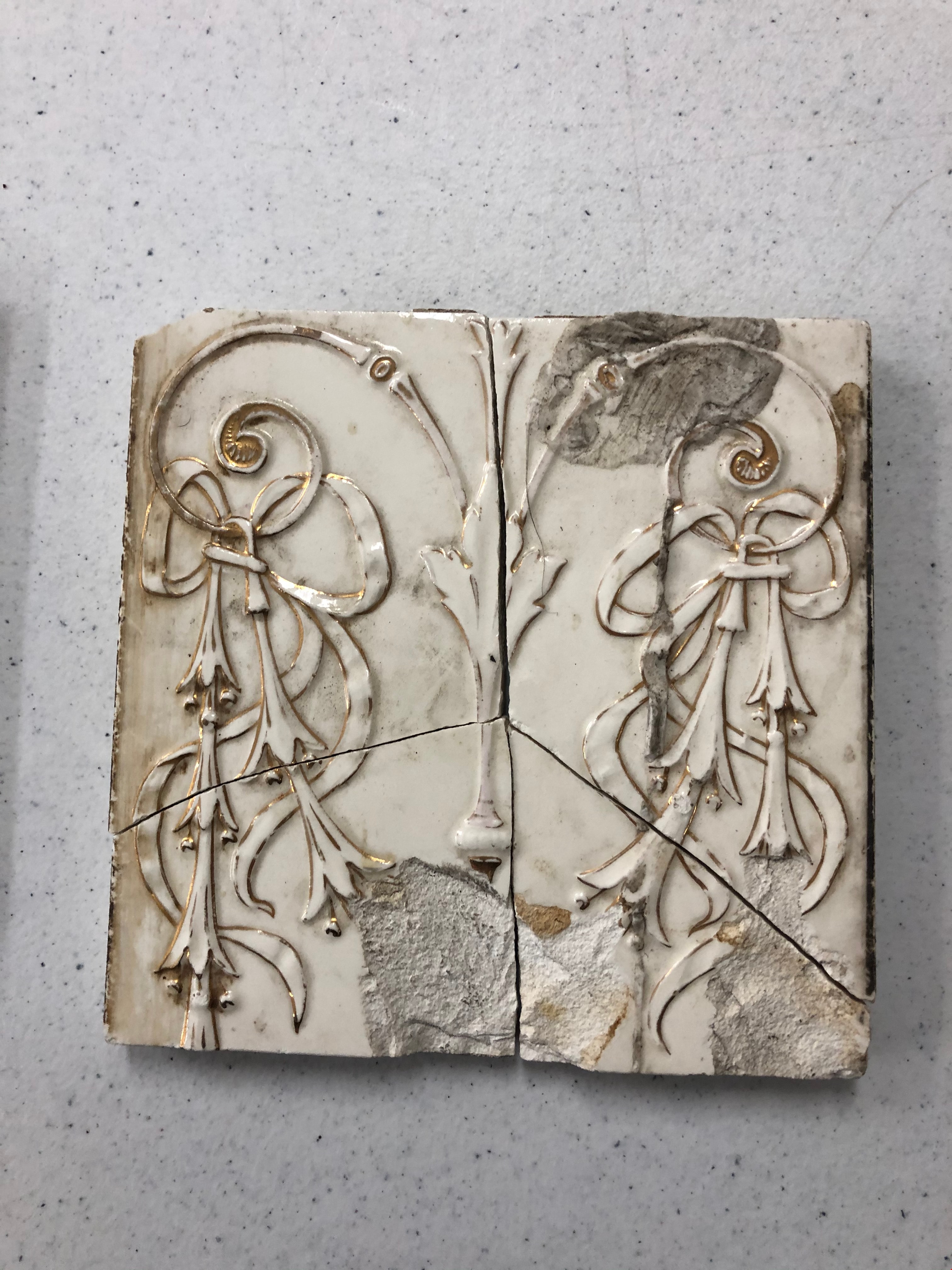
- Description
- White ceramic tile with gold design. The design is made up of two flowers attached to a gold curled tendril. At the top, a large flower follows the curled line. the line conitnues out of the centre of the flower and splits into two leafy tendrils. One of the leaves has a thick gold curl coming from it. A ribbon with a flower is tied to this gold curl (nearest to the bottom of the tile), and has six stamens coming from the flower. There is a large brown circular stain and lots of gray stains, the colour of dry wall putty. The tile has a clean diagonal split across the centre right near to where the ribbon attaches to the gold curl. The bottom corner is missing with another clean diagonal split, and small triangular piece missing along the largest split.
- Object History
- These tiles are from Glenedward Mansion, built in 1912. It was built at 3412 Kingsway, which later became 5152 Kingsway. They were salvaged when the mansion was demolished in the 1990s.
- Category
- 01. Built Environment Objects
- Classification
- Building Components - - Surface Elements
- Object Term
- Tile, Decorative
- Colour
- White
- Gold
- Measurements
- 8" h x 6" w
- Subjects
- Building Components
- Buildings - Heritage
- Historic Neighbourhood
- Edmonds (Historic Neighbourhood)
- Planning Study Area
- Windsor Area
Images
Tile
https://search.heritageburnaby.ca/link/museumartifact90836
- Repository
- Burnaby Village Museum
- Accession Code
- BV020.40.21
- Description
- White ceramic tile with gold design. The design is made up of a gold line down the centre with a leaf comprising the top half. Two gold curls emerge from either side of the line. Six bell-shaped flowers hang from these gold curls on each side and are tied with a ribbon. There is a large brown stain on the top right corner with two rough chips out of the bottom. This tile is split into nearly 4 equal parts.
- Object History
- These tiles are from Glenedward Mansion, built in 1912. It was built at 3412 Kingsway, which later became 5152 Kingsway. They were salvaged when the mansion was demolished in the 1990s.
- Category
- 01. Built Environment Objects
- Classification
- Building Components - - Surface Elements
- Object Term
- Tile, Decorative
- Colour
- White
- Gold
- Measurements
- 6" x 6"
- Subjects
- Building Components
- Buildings - Heritage
- Historic Neighbourhood
- Edmonds (Historic Neighbourhood)
- Planning Study Area
- Windsor Area
Images
![Triangle Conduit and Cable Ltd., [1960] thumbnail](/media/Hpo/_Data/_Archives_Images/_Unrestricted/001/112-001.jpg?width=280)
Triangle Conduit and Cable Ltd.
https://search.heritageburnaby.ca/link/archivedescription34708
- Repository
- City of Burnaby Archives
- Date
- [1960]
- Collection/Fonds
- Burnaby Historical Society fonds
- Description Level
- Item
- Physical Description
- 1 photograph : b&w ; 20 x 25 cm
- Scope and Content
- Photograph of the exterior of Triangle Conduit and Cable Ltd. at 7515 Gilley Avenue. A sign on the front of the building reads, "Triangle Conduit & Cable (Canada) Ltd." and the door is numbered 1902.
- Repository
- City of Burnaby Archives
- Date
- [1960]
- Collection/Fonds
- Burnaby Historical Society fonds
- Subseries
- Photographs subseries
- Physical Description
- 1 photograph : b&w ; 20 x 25 cm
- Description Level
- Item
- Record No.
- 112-001
- Access Restriction
- No restrictions
- Reproduction Restriction
- Reproduce for fair dealing purposes only
- Accession Number
- BHS2007-04
- Scope and Content
- Photograph of the exterior of Triangle Conduit and Cable Ltd. at 7515 Gilley Avenue. A sign on the front of the building reads, "Triangle Conduit & Cable (Canada) Ltd." and the door is numbered 1902.
- Subjects
- Buildings - Industrial
- Media Type
- Photograph
- Photographer
- Dominion Photo Company
- Notes
- Title based on contents of photograph
- Bottom left corner of photograph reads, "38891 Dominion Photo Co., Vancouver, B.C."
- Geographic Access
- Gilley Avenue
- Street Address
- 7515 Gilley Avenue
- Historic Neighbourhood
- Edmonds (Historic Neighbourhood)
- Planning Study Area
- Windsor Area
Images
![Triangle Conduit and Cable Ltd., [1960] thumbnail](/media/Hpo/_Data/_Archives_Images/_Unrestricted/001/112-001.jpg)

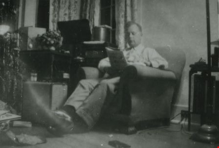
"Tubby" Heath
https://search.heritageburnaby.ca/link/archivedescription38030
- Repository
- City of Burnaby Archives
- Date
- 25 Dec. 1944 (date of original), copied 1991
- Collection/Fonds
- Burnaby Historical Society fonds
- Description Level
- Item
- Physical Description
- 1 photograph : b&w ; 2.9 x 4.2 cm print on contact sheet 20.6 x 26.3 cm
- Scope and Content
- Photograph of Arthur "Tubby" Heath sitting in the living room of the Le Grove house at 2224 Antrim Avenue (later renumbered 6957 Antrim Avenue) on Christmas day.
- Repository
- City of Burnaby Archives
- Date
- 25 Dec. 1944 (date of original), copied 1991
- Collection/Fonds
- Burnaby Historical Society fonds
- Subseries
- Burnaby Image Bank subseries
- Physical Description
- 1 photograph : b&w ; 2.9 x 4.2 cm print on contact sheet 20.6 x 26.3 cm
- Description Level
- Item
- Record No.
- 370-617
- Access Restriction
- No restrictions
- Reproduction Restriction
- No known restrictions
- Accession Number
- BHS1999-03
- Scope and Content
- Photograph of Arthur "Tubby" Heath sitting in the living room of the Le Grove house at 2224 Antrim Avenue (later renumbered 6957 Antrim Avenue) on Christmas day.
- Subjects
- Holidays - Christmas
- Names
- Heath, Arthur "Tubby"
- Media Type
- Photograph
- Notes
- Title based on contents of photograph
- 1 b&w copy negative accompanying
- Negative has a pink cast
- Geographic Access
- Antrim Avenue
- Street Address
- 6957 Antrim Avenue
- Historic Neighbourhood
- Central Park (Historic Neighbourhood)
- Planning Study Area
- Windsor Area
Images
![Tubby Heath and Anne Le Grove, [1945] (date of original), copied 1991 thumbnail](/media/hpo/_Data/_Archives_Images/_Unrestricted/370/370-615.jpg?width=280)
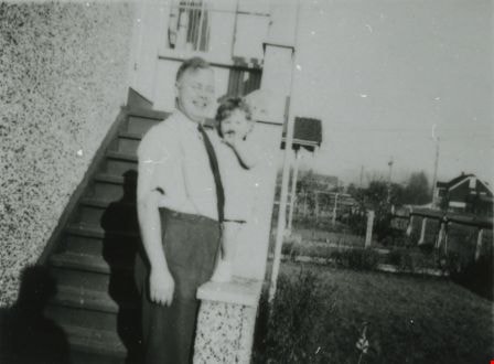
Tubby Heath and Anne Le Grove
https://search.heritageburnaby.ca/link/archivedescription38028
- Repository
- City of Burnaby Archives
- Date
- [1945] (date of original), copied 1991
- Collection/Fonds
- Burnaby Historical Society fonds
- Description Level
- Item
- Physical Description
- 1 photograph : b&w ; 2.8 x 3.8 cm print on contact sheet 20.6 x 26.3 cm
- Scope and Content
- Photograph of (left to right) Arthur "Tubby" Heath and Anne Le Grove standing outside of 2224 Antrim Avenue (later renumbered 6957 Antrim Avenue).
- Repository
- City of Burnaby Archives
- Date
- [1945] (date of original), copied 1991
- Collection/Fonds
- Burnaby Historical Society fonds
- Subseries
- Burnaby Image Bank subseries
- Physical Description
- 1 photograph : b&w ; 2.8 x 3.8 cm print on contact sheet 20.6 x 26.3 cm
- Description Level
- Item
- Record No.
- 370-615
- Access Restriction
- No restrictions
- Reproduction Restriction
- No known restrictions
- Accession Number
- BHS1999-03
- Scope and Content
- Photograph of (left to right) Arthur "Tubby" Heath and Anne Le Grove standing outside of 2224 Antrim Avenue (later renumbered 6957 Antrim Avenue).
- Media Type
- Photograph
- Notes
- Title based on contents of photograph
- 1 b&w copy negative accompanying
- Negative has a pink cast
- Geographic Access
- Antrim Avenue
- Street Address
- 6957 Antrim Avenue
- Historic Neighbourhood
- Central Park (Historic Neighbourhood)
- Planning Study Area
- Windsor Area
Images
![Tubby Heath and Anne Le Grove, [1945] (date of original), copied 1991 thumbnail](/media/hpo/_Data/_Archives_Images/_Unrestricted/370/370-615.jpg)
Tubby Heath and Anne Le Grove
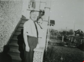
https://search.heritageburnaby.ca/link/archivedescription38036
- Repository
- City of Burnaby Archives
- Date
- December 10, 1944 (date of original), copied 1991
- Collection/Fonds
- Burnaby Historical Society fonds
- Description Level
- Item
- Physical Description
- 1 photograph : b&w ; 2.9 x 4.0 cm print on contact sheet 20.6 x 26.3 cm
- Scope and Content
- Photograph of (left to right) Arthur "Tubby" Heath and Anne Le Grove standing outside of 2224 Antrim Avenue (later renumbered 6957 Antrim Avenue).
- Repository
- City of Burnaby Archives
- Date
- December 10, 1944 (date of original), copied 1991
- Collection/Fonds
- Burnaby Historical Society fonds
- Subseries
- Burnaby Image Bank subseries
- Physical Description
- 1 photograph : b&w ; 2.9 x 4.0 cm print on contact sheet 20.6 x 26.3 cm
- Description Level
- Item
- Record No.
- 370-623
- Access Restriction
- No restrictions
- Reproduction Restriction
- No known restrictions
- Accession Number
- BHS1999-03
- Scope and Content
- Photograph of (left to right) Arthur "Tubby" Heath and Anne Le Grove standing outside of 2224 Antrim Avenue (later renumbered 6957 Antrim Avenue).
- Media Type
- Photograph
- Notes
- Title based on contents of photograph
- 1 b&w copy negative accompanying
- Negative has a pink cast
- Geographic Access
- Antrim Avenue
- Street Address
- 6957 Antrim Avenue
- Historic Neighbourhood
- Central Park (Historic Neighbourhood)
- Planning Study Area
- Windsor Area
Images
![Gilley Brothers Logging team, [1895]. . thumbnail](/media/hpo/_Data/_Archives_Images/_Unrestricted/371/461-003.jpg?width=280)
Vancouver Road (Kingsway)
https://search.heritageburnaby.ca/link/landmark729
- Repository
- Burnaby Heritage Planning
- Associated Dates
- 1860
- Heritage Value
- The street we know as Kingsway is one of the legacies of the Royal Engineers' military defences for New Westminster. The fear of an American attack prompted the construction of the False Creek trail - later known as Vancouver Road and now Kingsway - in 1860 to connect the capital city to the ice-free salt water harbour at English Bay.
- Historic Neighbourhood
- Central Park (Historic Neighbourhood)
- Edmonds (Historic Neighbourhood)
- Planning Study Area
- Maywood Area
- Marlborough Area
- Windsor Area
- Kingsway-Beresford Area
- Stride Avenue Area
- Edmonds Area
Images
![Gilley Brothers Logging team, [1895]. . thumbnail](/media/hpo/_Data/_Archives_Images/_Unrestricted/371/461-003.jpg)

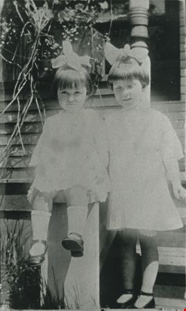
Viola and Mary Cram
https://search.heritageburnaby.ca/link/archivedescription35706
- Repository
- City of Burnaby Archives
- Date
- 1922 (date of original), copied 1986
- Collection/Fonds
- Burnaby Historical Society fonds
- Description Level
- Item
- Physical Description
- 1 photograph : b&w ; 12.7 x 17.8 cm print
- Scope and Content
- Photograph of sisters (left to right) Viola and Mary Cram, in front of the family home at Kingsway and what is now 6515 Denbigh Avenue. Mary Cram is five years old.
- Repository
- City of Burnaby Archives
- Date
- 1922 (date of original), copied 1986
- Collection/Fonds
- Burnaby Historical Society fonds
- Subseries
- Pioneer Tales subseries
- Physical Description
- 1 photograph : b&w ; 12.7 x 17.8 cm print
- Description Level
- Item
- Record No.
- 204-564
- Access Restriction
- No restrictions
- Reproduction Restriction
- No known restrictions
- Accession Number
- BHS1988-03
- Scope and Content
- Photograph of sisters (left to right) Viola and Mary Cram, in front of the family home at Kingsway and what is now 6515 Denbigh Avenue. Mary Cram is five years old.
- Names
- Cram, Viola
- Vogt, Mary Cram
- Media Type
- Photograph
- Notes
- Title based on contents of photograph
- Geographic Access
- Denbigh Avenue
- Street Address
- 6515 Denbigh Avenue
- Historic Neighbourhood
- Central Park (Historic Neighbourhood)
- Planning Study Area
- Windsor Area
Images
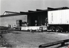
Warehouse on Gilley Avenue
https://search.heritageburnaby.ca/link/archivedescription79368
- Repository
- City of Burnaby Archives
- Date
- September 16, 1976
- Collection/Fonds
- Burnaby Public Library Contemporary Visual Archive Project
- Description Level
- Item
- Physical Description
- 1 photograph : b&w ; 11 x 16 cm mounted on cardboard
- Scope and Content
- Photograph shows men unloading truck at warehouse at 7515 Gilley Avenue. The warehouse, at the time of the photograph, was owned by Miloni Food Importers. Miloni Food Importers was previously located on Hastings Street and was founded around 1956.
- Repository
- City of Burnaby Archives
- Date
- September 16, 1976
- Collection/Fonds
- Burnaby Public Library Contemporary Visual Archive Project
- Physical Description
- 1 photograph : b&w ; 11 x 16 cm mounted on cardboard
- Description Level
- Item
- Record No.
- 556-267
- Access Restriction
- No restrictions
- Reproduction Restriction
- Reproduce for fair dealing purposes only
- Accession Number
- 2013-13
- Scope and Content
- Photograph shows men unloading truck at warehouse at 7515 Gilley Avenue. The warehouse, at the time of the photograph, was owned by Miloni Food Importers. Miloni Food Importers was previously located on Hastings Street and was founded around 1956.
- Subjects
- Buildings - Industrial
- Names
- Miloni Food Importers
- Media Type
- Photograph
- Photographer
- Ross, Martha
- Notes
- Scope note taken directly from BPL photograph description.
- 1 b&w copy negative : 10 x 12.5 cm accompanying
- Geographic Access
- Gilley Avenue
- Street Address
- 7515 Gilley Avenue
- Planning Study Area
- Windsor Area
Images

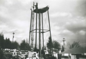
Water tower being dismantled
https://search.heritageburnaby.ca/link/archivedescription36964
- Repository
- City of Burnaby Archives
- Date
- 1948 (date of original), copied 1992
- Collection/Fonds
- Burnaby Historical Society fonds
- Description Level
- Item
- Physical Description
- 1 photograph : b&w ; 8.8 x 12.7 cm print
- Scope and Content
- Photograph of a water tower being dismantled on the east side of Royal Oak Avenue and Kingsway.
- Repository
- City of Burnaby Archives
- Date
- 1948 (date of original), copied 1992
- Collection/Fonds
- Burnaby Historical Society fonds
- Subseries
- Burnaby Centennial Anthology subseries
- Physical Description
- 1 photograph : b&w ; 8.8 x 12.7 cm print
- Description Level
- Item
- Record No.
- 315-422
- Access Restriction
- No restrictions
- Reproduction Restriction
- No known restrictions
- Accession Number
- BHS1994-04
- Scope and Content
- Photograph of a water tower being dismantled on the east side of Royal Oak Avenue and Kingsway.
- Subjects
- Structures - Water Tanks and Towers
- Media Type
- Photograph
- Notes
- Title based on contents of photograph
- Geographic Access
- Royal Oak Avenue
- Kingsway
- Historic Neighbourhood
- Central Park (Historic Neighbourhood)
- Planning Study Area
- Windsor Area
Images
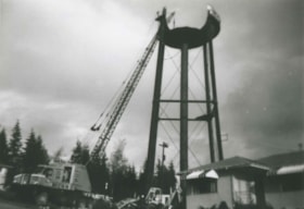
Water tower being dismantled
https://search.heritageburnaby.ca/link/archivedescription36965
- Repository
- City of Burnaby Archives
- Date
- 1948 (date of original), copied 1992
- Collection/Fonds
- Burnaby Historical Society fonds
- Description Level
- Item
- Physical Description
- 1 photograph : b&w ; 8.8 x 12.7 cm print
- Scope and Content
- Photograph of a water tower being dismantled by crane on the east side of Royal Oak Avenue and Kingsway.
- Repository
- City of Burnaby Archives
- Date
- 1948 (date of original), copied 1992
- Collection/Fonds
- Burnaby Historical Society fonds
- Subseries
- Burnaby Centennial Anthology subseries
- Physical Description
- 1 photograph : b&w ; 8.8 x 12.7 cm print
- Description Level
- Item
- Record No.
- 315-423
- Access Restriction
- No restrictions
- Reproduction Restriction
- No known restrictions
- Accession Number
- BHS1994-04
- Scope and Content
- Photograph of a water tower being dismantled by crane on the east side of Royal Oak Avenue and Kingsway.
- Subjects
- Structures - Water Tanks and Towers
- Media Type
- Photograph
- Notes
- Title based on contents of photograph
- Geographic Access
- Royal Oak Avenue
- Kingsway
- Historic Neighbourhood
- Central Park (Historic Neighbourhood)
- Planning Study Area
- Windsor Area
Images

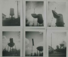
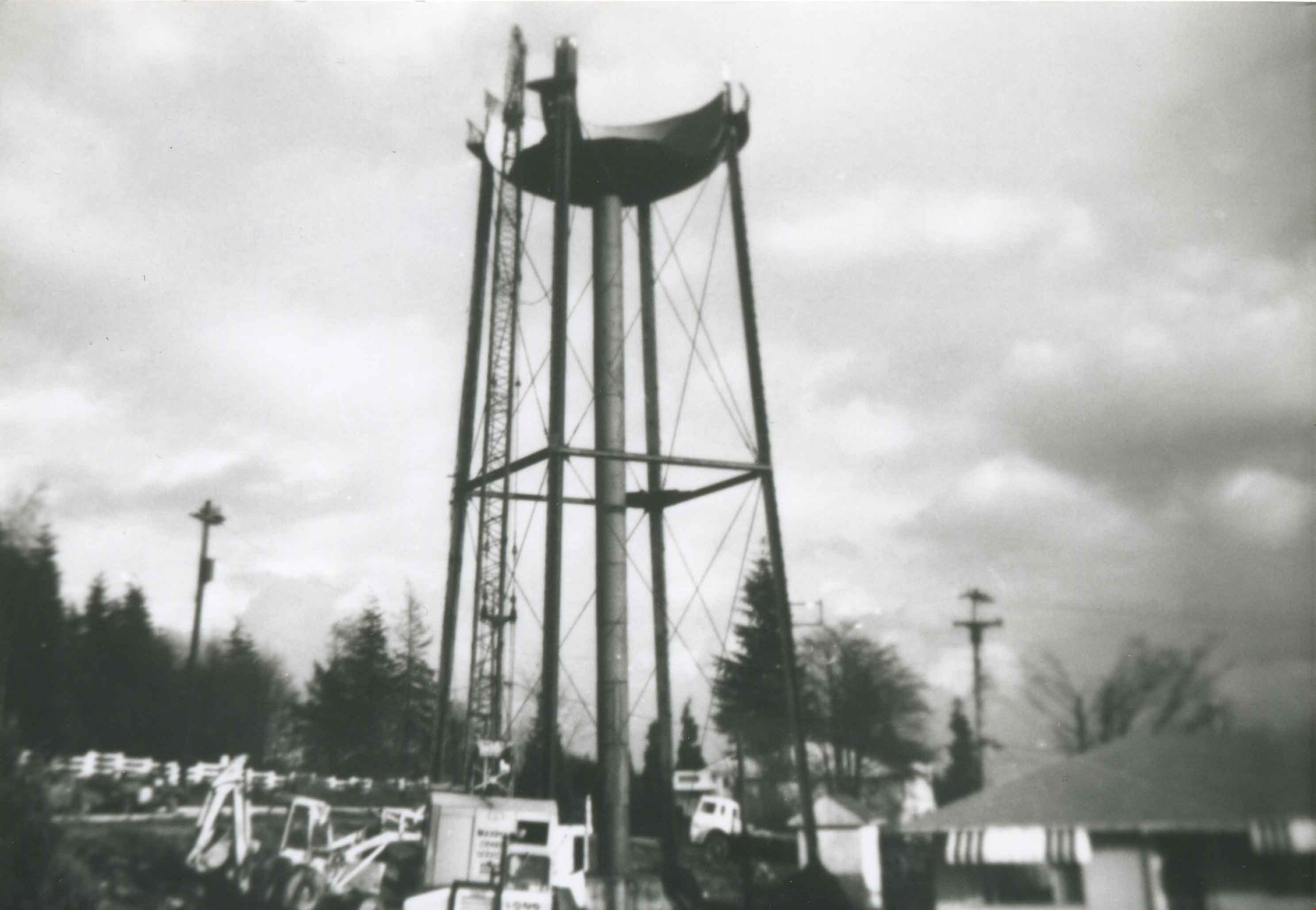
Water tower being dismantled
https://search.heritageburnaby.ca/link/archivedescription36966
- Repository
- City of Burnaby Archives
- Date
- 1948 (date of original), copied 1992
- Collection/Fonds
- Burnaby Historical Society fonds
- Description Level
- Item
- Physical Description
- 1 photograph : b&w ; 8.6 x 10.3 cm print
- Scope and Content
- Photograph of a series of six photographs of a water tower being dismantled on the east side of Royal Oak Avenue and Kingsway.
- Repository
- City of Burnaby Archives
- Date
- 1948 (date of original), copied 1992
- Collection/Fonds
- Burnaby Historical Society fonds
- Subseries
- Burnaby Centennial Anthology subseries
- Physical Description
- 1 photograph : b&w ; 8.6 x 10.3 cm print
- Description Level
- Item
- Record No.
- 315-424
- Access Restriction
- No restrictions
- Reproduction Restriction
- No known restrictions
- Accession Number
- BHS1994-04
- Scope and Content
- Photograph of a series of six photographs of a water tower being dismantled on the east side of Royal Oak Avenue and Kingsway.
- Subjects
- Structures - Water Tanks and Towers
- Media Type
- Photograph
- Notes
- Title based on contents of photograph
- Geographic Access
- Royal Oak Avenue
- Kingsway
- Historic Neighbourhood
- Central Park (Historic Neighbourhood)
- Planning Study Area
- Windsor Area
Images


Williamson children
https://search.heritageburnaby.ca/link/archivedescription35403
- Repository
- City of Burnaby Archives
- Date
- 1922 (date of original), copied 1986
- Collection/Fonds
- Burnaby Historical Society fonds
- Description Level
- Item
- Physical Description
- 1 photograph : b&w ; 12.7 x 17.8 cm print
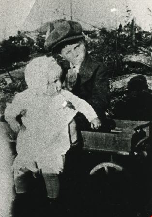
- Scope and Content
- Photograph of Harry Williamson and Marjorie Williamson sitting in a wagon at 6965 Antrim Avenue. In the background can be seen charred trees that were destroyed by a brush fire which swept the Antrim Avenue property in 1922. Harry and Marjorie were the children of Minnie Sharples Williamson.
- Repository
- City of Burnaby Archives
- Date
- 1922 (date of original), copied 1986
- Collection/Fonds
- Burnaby Historical Society fonds
- Subseries
- Pioneer Tales subseries
- Physical Description
- 1 photograph : b&w ; 12.7 x 17.8 cm print
- Description Level
- Item
- Record No.
- 204-260
- Access Restriction
- No restrictions
- Reproduction Restriction
- No known restrictions
- Accession Number
- BHS1988-03
- Scope and Content
- Photograph of Harry Williamson and Marjorie Williamson sitting in a wagon at 6965 Antrim Avenue. In the background can be seen charred trees that were destroyed by a brush fire which swept the Antrim Avenue property in 1922. Harry and Marjorie were the children of Minnie Sharples Williamson.
- Subjects
- Transportation - Wagons
- Media Type
- Photograph
- Notes
- Title based on contents of photograph
- Geographic Access
- Antrim Avenue
- Street Address
- 6965 Antrim Avenue
- Historic Neighbourhood
- Central Park (Historic Neighbourhood)
- Planning Study Area
- Windsor Area
Images
![Williamson family home, [1922] (date of original), copied 1986 thumbnail](/media/hpo/_Data/_Archives_Images/_Unrestricted/204/204-259.jpg?width=280)
Williamson family home
https://search.heritageburnaby.ca/link/archivedescription35402
- Repository
- City of Burnaby Archives
- Date
- [1922] (date of original), copied 1986
- Collection/Fonds
- Burnaby Historical Society fonds
- Description Level
- Item
- Physical Description
- 1 photograph : b&w ; 12.7 x 17.8 cm print
- Scope and Content
- Photograph of the original Williamson shack at 6965 Antrim Avenue. This building later became a chicken house when another family home was built. Mr. Williamson is standing with his wife Minnie Williamson (nee Sharples) who is holding their baby daughter, Marjorie.
- Repository
- City of Burnaby Archives
- Date
- [1922] (date of original), copied 1986
- Collection/Fonds
- Burnaby Historical Society fonds
- Subseries
- Pioneer Tales subseries
- Physical Description
- 1 photograph : b&w ; 12.7 x 17.8 cm print
- Description Level
- Item
- Record No.
- 204-259
- Access Restriction
- No restrictions
- Reproduction Restriction
- No known restrictions
- Accession Number
- BHS1988-03
- Scope and Content
- Photograph of the original Williamson shack at 6965 Antrim Avenue. This building later became a chicken house when another family home was built. Mr. Williamson is standing with his wife Minnie Williamson (nee Sharples) who is holding their baby daughter, Marjorie.
- Subjects
- Buildings - Residential - Houses
- Media Type
- Photograph
- Notes
- Title based on contents of photograph
- Geographic Access
- Antrim Avenue
- Street Address
- 6965 Antrim Avenue
- Historic Neighbourhood
- Central Park (Historic Neighbourhood)
- Planning Study Area
- Windsor Area
Images
![Williamson family home, [1922] (date of original), copied 1986 thumbnail](/media/hpo/_Data/_Archives_Images/_Unrestricted/204/204-259.jpg)

Williamson family home
https://search.heritageburnaby.ca/link/archivedescription35404
- Repository
- City of Burnaby Archives
- Date
- 1930 (date of original), copied 1986
- Collection/Fonds
- Burnaby Historical Society fonds
- Description Level
- Item
- Physical Description
- 1 photograph : b&w ; 12.7 x 17.8 cm print
- Scope and Content
- Photograph of the completed Williamson family home at 6965 Antrim Avenue. Pictured (left to right) Marjorie Williamson and Elsie Williamson, daughters of Mr. Williamson and Mrs. Minnie Williamson, who built the home.
- Repository
- City of Burnaby Archives
- Date
- 1930 (date of original), copied 1986
- Collection/Fonds
- Burnaby Historical Society fonds
- Subseries
- Pioneer Tales subseries
- Physical Description
- 1 photograph : b&w ; 12.7 x 17.8 cm print
- Description Level
- Item
- Record No.
- 204-261
- Access Restriction
- No restrictions
- Reproduction Restriction
- No known restrictions
- Accession Number
- BHS1988-03
- Scope and Content
- Photograph of the completed Williamson family home at 6965 Antrim Avenue. Pictured (left to right) Marjorie Williamson and Elsie Williamson, daughters of Mr. Williamson and Mrs. Minnie Williamson, who built the home.
- Subjects
- Toys - Dolls
- Media Type
- Photograph
- Notes
- Title based on contents of photograph
- Geographic Access
- Antrim Avenue
- Street Address
- 6965 Antrim Avenue
- Historic Neighbourhood
- Central Park (Historic Neighbourhood)
- Planning Study Area
- Windsor Area
Images

Windsor Area Community School Project
https://search.heritageburnaby.ca/link/councilreport27297
- Repository
- City of Burnaby Archives
- Report ID
- 19127
- Meeting Date
- 21-Jan-1974
- Format
- Council - Manager's Report
- Manager's Report No.
- 5
- Item No.
- 13
- Collection/Fonds
- City Council and Office of the City Clerk fonds
- Repository
- City of Burnaby Archives
- Report ID
- 19127
- Meeting Date
- 21-Jan-1974
- Format
- Council - Manager's Report
- Manager's Report No.
- 5
- Item No.
- 13
- Collection/Fonds
- City Council and Office of the City Clerk fonds
Documents

Windsor Neighbourhood
https://search.heritageburnaby.ca/link/landmark803
- Repository
- Burnaby Heritage Planning
- Associated Dates
- 1955-2008
- Heritage Value
- The Windsor Neighbourhood comprises a number of different districts with different characteristics. To the north, stretching to the border of the Deer Lake Park, is the primarily residential area that was developed after the building boom of the 1950s and now consists of a mix of single-family and multi-family housing. To the south, from Kingsway to the Skytrain line, an industrial area was maintained along with a significant commercial corridor along Kingsway. In recent years, the growth and development of this area has been guided by the Royal Oak Community Plan adopted by Council in 1999.
- Planning Study Area
- Windsor Area
Images
