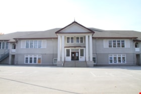
Brantford Elementary School
https://search.heritageburnaby.ca/link/landmark809
- Repository
- Burnaby Heritage Planning
- Geographic Access
- Brantford Avenue
- Associated Dates
- 1965
- Heritage Value
- As housing developments extended north from Kingsway, pupil enrolments grew at Windsor and at Morley Schools so Brantford was built equidistant from the two to help ease enrolment problems. Brantford Elementary school opened in 1965 and was similar in structure to other schools built in Burnaby during this period - no basements, no second stories and no high stairways. Classrooms were built in a line and could easily be added to as enrolments increased. Brantford had room additions in 1969.
- Historic Neighbourhood
- Edmonds (Historic Neighbourhood)
- Planning Study Area
- Kingsway-Beresford Area
- Street Address
- 6512 Brantford Avenue
- Street View URL
- Google Maps Street View
Images
Jubilee Grove Arch
https://search.heritageburnaby.ca/link/landmark533
- Repository
- Burnaby Heritage Planning
- Description
- The Jubilee Grove Arch sits at the corner of Kingsway and Patterson Avenue. Located within Central Park, the ceremonial arch and its decorative plantings provide a visual anchor to the northeast corner and entry point to the park.
- Associated Dates
- 1939
- Formal Recognition
- Heritage Designation, Community Heritage Register
- Street View URL
- Google Maps Street View
- Repository
- Burnaby Heritage Planning
- Geographic Access
- Imperial Street
- Associated Dates
- 1939
- Formal Recognition
- Heritage Designation, Community Heritage Register
- Enactment Type
- Bylaw No. 9807
- Enactment Date
- 23/11/1992
- Description
- The Jubilee Grove Arch sits at the corner of Kingsway and Patterson Avenue. Located within Central Park, the ceremonial arch and its decorative plantings provide a visual anchor to the northeast corner and entry point to the park.
- Heritage Value
- Jubilee Grove Arch was dedicated as part of the municipality’s celebration of the Jubilee of the coronation of King George V and was dedicated during Burnaby’s annual May Day celebrations in 1935. Much of the construction work was carried out by local citizens under the direction of the Burnaby Engineering Department through a Depression era work relief program that provided a way for local residents to pay their taxes. The garden was also chosen as the site for the ceremonial planting of an oak tree from the Royal Forest at Windsor, in honor of the Coronation of King George VI and Queen Elizabeth in 1937. The original bronze garden dedication plaque and oak tree remain at the site today. The decorative stone arch was erected in 1939 as a symbol of Burnaby's, and the Lower Mainland of British Columbia’s, strong ties to the English monarchy at the time, and the arch’s unveiling during May Day ceremonies shows the social role that such a commemorative feature played both to the local government and people of Burnaby. It was erected just prior to the Royal Visit of 1939, the first time that reigning British monarchs had travelled to Canada. Built of Haddington Island sandstone, the arch itself was reconstructed from a salvaged architectural element of a historic Vancouver landmark. The arch originally framed the entrance door to the Vancouver Club building in Vancouver, built in 1893-94 on West Hastings Street and designed by architect C.O. Wickenden. The building was demolished in 1930, however the arch was stored and rebuilt as the focal point of the Jubilee Grove after being bought by the Municipality of Burnaby. The work was undertaken by Italian-born stone mason Rizieri Stefanini (1879-1954), the owner of Burnaby Monumental Works. The re-use of the arch symbolizes the close tie between Vancouver and Burnaby and the joint evolution of the neighbouring cities.
- Defining Elements
- The Jubilee Grove Arch has character-defining elements that recognize it both as a remnant of a past building and as a new and individual structure. These include its: - axial diagonal placement and prominent corner location marking one of the entries to Central Park - visibility and accessibility as a public monument - hand carved stone blocks of Haddington Island sandstone - decorative twisted-rope motif carved to outline the arch - supporting rusticated sidewalls with planting urns - original bronze dedication plaque - flanking ornamental gardens - Royal Oak tree and plaque
- Historic Neighbourhood
- Central Park (Historic Neighbourhood)
- Planning Study Area
- Maywood Area
- Organization
- City of Burnaby
- Architect
- C.O. Wickenden
- Function
- Primary Current--Park Fixture
- Primary Historic--Park Fixture
- Community
- Burnaby
- Cadastral Identifier
- P.I.D. No. 017-767-172 Legal Description: Block B of Lot 2 Except Firstly: Part on Plan 8669 and Secondly: Part on Plan LMP4689 District Lot 151, Group 1, New Westminster District, Plan 3443
- Boundaries
- The property (Central Park) is a municipally-owned park that lies at the western edge of Burnaby, between 49th Avenue to the south, Kingsway to the north, Boundary Road to the west and Patterson Avenue to the east.
- Area
- 853,403.82
- Contributing Resource
- Structure
- Landscape Feature
- Ownership
- Public (local)
- Documentation
- Heritage Site Files: PC77000 20. City of Burnaby Planning and Building Department, 4949 Canada Way, Burnaby, B.C., V5G 1M2
- Names
- Burnaby Monumental Works
- Street Address
- 3883 Imperial Street
- Street View URL
- Google Maps Street View
Images
Kingsway
https://search.heritageburnaby.ca/link/landmark775
- Repository
- Burnaby Heritage Planning
- Associated Dates
- 1913
- Heritage Value
- The years 1911-1912 saw great expansion and settlement in Burnaby and large public works projects were undertaken to service the growing community. One project that was determined to be a necessity was the construction of a proper highway between New Westminster and Vancouver. The Province and the Municipality agreed to share the costs of construction (with Burnaby paying 25% and the Province 75%) and so Kingsway was built to improve the current Vancouver Road. The road was named after the famous King's Way in London, England.
- Historic Neighbourhood
- Central Park (Historic Neighbourhood)
- Edmonds (Historic Neighbourhood)
- Planning Study Area
- Maywood Area
- Marlborough Area
- Windsor Area
- Kingsway-Beresford Area
- Stride Avenue Area
- Edmonds Area
Images
Nelson Avenue School
https://search.heritageburnaby.ca/link/landmark625
- Repository
- Burnaby Heritage Planning
- Description
- School building.
- Associated Dates
- 1927
- Street View URL
- Google Maps Street View
- Repository
- Burnaby Heritage Planning
- Geographic Access
- Irmin Street
- Associated Dates
- 1927
- Description
- School building.
- Heritage Value
- Nelson Avenue School was established in 1912 to serve the Alta Vista district of Burnaby. Architects Bowman & Cullerne designed this Classical Revival style school which was built as the annex to the original school building in 1927 and was a twin structure to the original Windsor Street School building. It once featured a columned porch but has been altered with a coat of stucco over the original main floor siding and replacement windows. It still retains its distinctive hipped roof with a domed octagonal roof ventilator. Harold Cullerne (1890-1976) joined J.H. Bowman (1864-1943) in a partnership that lasted from 1919 to 1934. The firm specialized in school design, and their project list includes Seaforth School (1922, now relocated to Burnaby Village Museum), Burnaby North High School (1923), and Windsor Street School (1924).
- Locality
- Alta Vista
- Historic Neighbourhood
- Alta Vista (Historic Neighbourhood)
- Planning Study Area
- Sussex-Nelson Area
- Architect
- Bowman & Cullerne
- Contributing Resource
- Building
- Street Address
- 4850 Irmin Street
- Street View URL
- Google Maps Street View
Images
Rosser Elementary School
https://search.heritageburnaby.ca/link/landmark636
- Repository
- Burnaby Heritage Planning
- Description
- School building.
- Associated Dates
- 1923
- Other Names
- NORTH BURNABY HIGH SCHOOL
- Street View URL
- Google Maps Street View
- Repository
- Burnaby Heritage Planning
- Other Names
- NORTH BURNABY HIGH SCHOOL
- Geographic Access
- Pandora Street
- Associated Dates
- 1923
- Description
- School building.
- Heritage Value
- Originally built as North Burnaby High School, this eight-room school became Rosser Avenue School in 1945. It has been altered with replacement windows, the application of stucco over the original siding and an addition, but has retained its historical form, including a hipped roof with half-timbered gables and a domed roof ventilator. The Rosser Elementary School was designed by the architectural firm of Bowman & Cullerne, who specialized in school design. The firm’s projects include Seaforth School (1922, now relocated to Burnaby Village Museum), Windsor Street School (1923), and Nelson Avenue School (1927).
- Locality
- Vancouver Heights
- Historic Neighbourhood
- Vancouver Heights (Historic Neighbourhood)
- Planning Study Area
- Burnaby Heights Area
- Architect
- Bowman and Cullerne
- Area
- 10579.94
- Contributing Resource
- Building
- Street Address
- 4375 Pandora Street
- Street View URL
- Google Maps Street View
Images
Vancouver Road (Kingsway)
https://search.heritageburnaby.ca/link/landmark729
- Repository
- Burnaby Heritage Planning
- Associated Dates
- 1860
- Heritage Value
- The street we know as Kingsway is one of the legacies of the Royal Engineers' military defences for New Westminster. The fear of an American attack prompted the construction of the False Creek trail - later known as Vancouver Road and now Kingsway - in 1860 to connect the capital city to the ice-free salt water harbour at English Bay.
- Historic Neighbourhood
- Central Park (Historic Neighbourhood)
- Edmonds (Historic Neighbourhood)
- Planning Study Area
- Maywood Area
- Marlborough Area
- Windsor Area
- Kingsway-Beresford Area
- Stride Avenue Area
- Edmonds Area
Images
Windsor Neighbourhood
https://search.heritageburnaby.ca/link/landmark803
- Repository
- Burnaby Heritage Planning
- Associated Dates
- 1955-2008
- Heritage Value
- The Windsor Neighbourhood comprises a number of different districts with different characteristics. To the north, stretching to the border of the Deer Lake Park, is the primarily residential area that was developed after the building boom of the 1950s and now consists of a mix of single-family and multi-family housing. To the south, from Kingsway to the Skytrain line, an industrial area was maintained along with a significant commercial corridor along Kingsway. In recent years, the growth and development of this area has been guided by the Royal Oak Community Plan adopted by Council in 1999.
- Planning Study Area
- Windsor Area
Images
Windsor Street School
https://search.heritageburnaby.ca/link/landmark659
- Repository
- Burnaby Heritage Planning
- Description
- School building.
- Associated Dates
- 1924
- Street View URL
- Google Maps Street View
- Repository
- Burnaby Heritage Planning
- Geographic Access
- Imperial Street
- Associated Dates
- 1924
- Description
- School building.
- Heritage Value
- This school was built to replace Kingsway East School, which became part of Burnaby South High School. Architects Bowman & Cullerne designed the school in 1924; additions were made in 1927. The school features a distinctive double-height gabled entrance, a broad hipped roof and an octagonal rooftop ventilator. The Windsor Street School was designed by the architectural firm of Bowman & Cullerne, who specialized in school design. The firm’s projects include Seaforth School (1922, now relocated to Burnaby Village Museum), Burnaby North High School (1923), and Nelson Avenue School (1927).
- Locality
- Edmonds
- Historic Neighbourhood
- Edmonds (Historic Neighbourhood)
- Planning Study Area
- Windsor Area
- Architect
- Bowman & Cullerne
- Area
- 3716.12
- Contributing Resource
- Building
- Street Address
- 6166 Imperial Street
- Street View URL
- Google Maps Street View


![Gilley Brothers Logging team, [1895]. . thumbnail](/media/hpo/_Data/_Archives_Images/_Unrestricted/371/461-003.jpg?width=280)

