Narrow Results By
Subject
- Advertising Medium - Signs and Signboards 6
- Aerial Photographs 1
- Agriculture - Farms 2
- Agriculture - Fruit and Berries 2
- Animals - Cows 1
- Animals - Dogs 3
- Animals - Goats 2
- Animals - Poultry 3
- Building Components 8
- Buildings - Agricultural 1
- Buildings - Agricultural - Barns 1
- Buildings - Agricultural - Greenhouses 2
Creator
- Bartel, Mario 4
- Bellinger, Bernard 11
- Bowman & Cullerne 1
- British Columbia Underwriters' Association 3
- Chapman, Fred 1
- Cheung, Nakita 3
- Dominion Photo Company 1
- Henderson, Norman M. "Norm" 1
- McCarron, John 5
- Norton, Paul 10
- Plan Department, British Columbia Insurance Underwriters' Association 3
- Printed on back of postcard: "Pub. by Living Colour Advertising Agencies, 809 21st St., New West'r, BC - 526-6612" and "Made in Canada / Dexter Color, Canada Ltd., Cornwall, Ontario" 1

Harry and Hannah Sellers
https://search.heritageburnaby.ca/link/archivedescription35236
- Repository
- City of Burnaby Archives
- Date
- 1917 (date of original), copied 1986
- Collection/Fonds
- Burnaby Historical Society fonds
- Description Level
- Item
- Physical Description
- 1 photograph : b&w ; 12.7 x 17.8 cm print
- Scope and Content
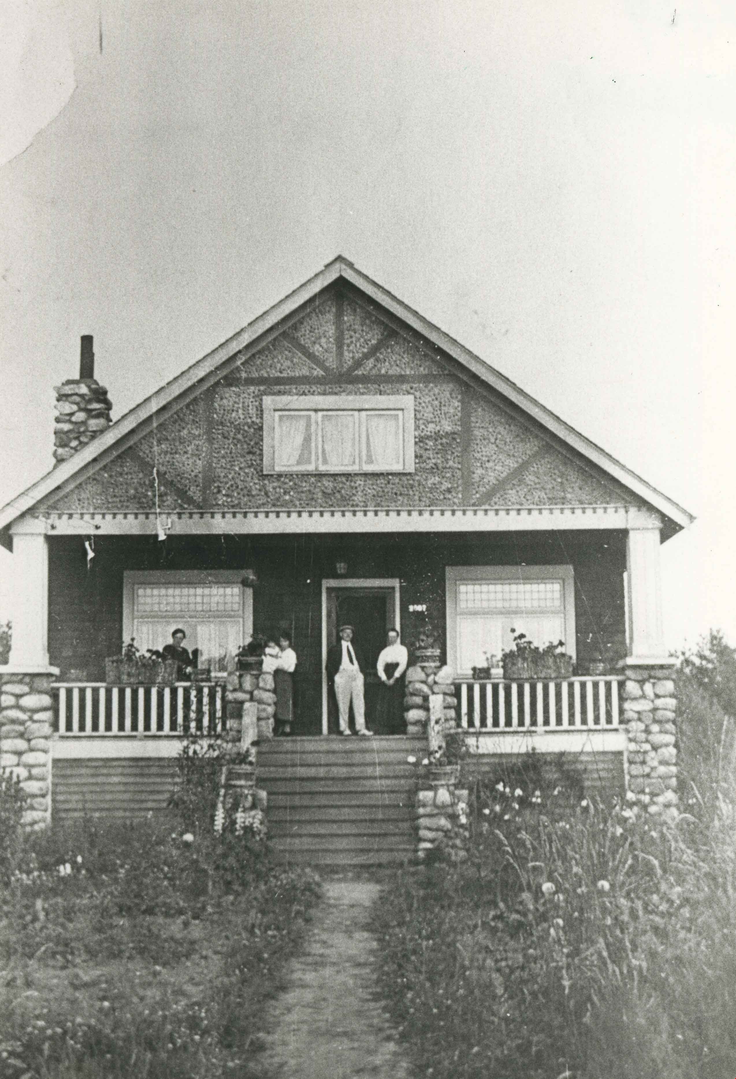
- Photograph of Harry Sellers and wife Hannah Sellers, with other family members. They rented this house at Imperial Street and Royal Oak for $10.00 per month after being married. Rent was raised to $12.00 during the next six years. They moved into their own home in 1923.
- Repository
- City of Burnaby Archives
- Date
- 1917 (date of original), copied 1986
- Collection/Fonds
- Burnaby Historical Society fonds
- Subseries
- Pioneer Tales subseries
- Physical Description
- 1 photograph : b&w ; 12.7 x 17.8 cm print
- Description Level
- Item
- Record No.
- 204-093
- Access Restriction
- No restrictions
- Reproduction Restriction
- No known restrictions
- Accession Number
- BHS1988-03
- Scope and Content
- Photograph of Harry Sellers and wife Hannah Sellers, with other family members. They rented this house at Imperial Street and Royal Oak for $10.00 per month after being married. Rent was raised to $12.00 during the next six years. They moved into their own home in 1923.
- Subjects
- Buildings - Residential - Houses
- Media Type
- Photograph
- Notes
- Title based on contents of photograph
- Geographic Access
- Royal Oak Avenue
- Street Address
- 6756 Royal Oak Avenue
- Historic Neighbourhood
- Central Park (Historic Neighbourhood)
- Planning Study Area
- Windsor Area
Images
Highland Park station dinky store
https://search.heritageburnaby.ca/link/archivedescription35770
- Repository
- City of Burnaby Archives
- Date
- 1935
- Collection/Fonds
- Burnaby Historical Society fonds
- Description Level
- Item
- Physical Description
- 1 photograph : b&w ; 12.7 x 17.8 cm print
- Scope and Content
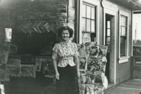
- Photograph of the "dinky" store (so-called because of its small size) at Highland Park Interurban station at Buller Avenue. In front: Margaret Thould. Lionel Thould, who opened this store, later opened a similar store at Fraser Arm Interurban station and gave up the Highland Park store when buses…
- Repository
- City of Burnaby Archives
- Date
- 1935
- Collection/Fonds
- Burnaby Historical Society fonds
- Subseries
- Pioneer Tales subseries
- Physical Description
- 1 photograph : b&w ; 12.7 x 17.8 cm print
- Description Level
- Item
- Record No.
- 204-628
- Access Restriction
- No restrictions
- Reproduction Restriction
- No known restrictions
- Accession Number
- BHS1988-03
- Scope and Content
- Photograph of the "dinky" store (so-called because of its small size) at Highland Park Interurban station at Buller Avenue. In front: Margaret Thould. Lionel Thould, who opened this store, later opened a similar store at Fraser Arm Interurban station and gave up the Highland Park store when buses replaced first street cars, then Interurban trams.
- Media Type
- Photograph
- Notes
- Title based on contents of photograph
- Geographic Access
- Buller Avenue
- Central Park Interurban line
- Planning Study Area
- Windsor Area
Images

![Home Station at Royal Oak and Kingsway, [1950] (date of original), copied [1999] thumbnail](/media/hpo/_Data/_BVM_Images/1990/199900180001.jpg?width=280)
Home Station at Royal Oak and Kingsway
https://search.heritageburnaby.ca/link/museumdescription1381
- Repository
- Burnaby Village Museum
- Date
- [1950] (date of original), copied [1999]
- Collection/Fonds
- Burnaby Village Museum Photograph collection
- Description Level
- Item
- Physical Description
- 1 photograph : sepia ; 15 x 25.5 cm laser print
- Scope and Content
- Photograph of Home Station owned by Ted Hopper located at Royal Oak and Kingsway. Edward Tarling is visible operating a Model 'C' Oliver tractor to clear the snow out front.
- Repository
- Burnaby Village Museum
- Collection/Fonds
- Burnaby Village Museum Photograph collection
- Description Level
- Item
- Physical Description
- 1 photograph : sepia ; 15 x 25.5 cm laser print
- Scope and Content
- Photograph of Home Station owned by Ted Hopper located at Royal Oak and Kingsway. Edward Tarling is visible operating a Model 'C' Oliver tractor to clear the snow out front.
- Names
- Tarling, Edward
- Geographic Access
- Royal Oak Avenue
- Kingsway
- Accession Code
- BV999.18.1
- Access Restriction
- Restricted access
- Reproduction Restriction
- May be restricted by third party rights
- Date
- [1950] (date of original), copied [1999]
- Media Type
- Photograph
- Historic Neighbourhood
- Central Park (Historic Neighbourhood)
- Planning Study Area
- Windsor Area
- Scan Resolution
- 600
- Scan Date
- 08-Jun-09
- Scale
- 100
- Notes
- Title based on contents of photograph
- Note on recto of laser print reads: "HOME STATION - AT ROYAL OAK & Kingway [sic] (Now SAFEWAY) BURNABY STATION OWNED BY MR. TED HOPPER - - 1950 - ED TARLING OPERATING 'C' model OLIVER TRACTOR"
Images
![Home Station at Royal Oak and Kingsway, [1950] (date of original), copied [1999] thumbnail](/media/hpo/_Data/_BVM_Images/1990/199900180001.jpg)
House at 6590 Randolph Avenue
https://search.heritageburnaby.ca/link/archivedescription78972
- Repository
- City of Burnaby Archives
- Date
- September 16,1976
- Collection/Fonds
- Burnaby Public Library Contemporary Visual Archive Project
- Description Level
- Item
- Physical Description
- 1 photograph : b&w ; 11 x 16 cm mounted on cardboard
- Scope and Content
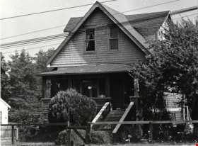
- Photograph shows a house at 6590 Randolph Avenue. The McLeod family dog, Fluffy, is lying on the front steps.
- Repository
- City of Burnaby Archives
- Date
- September 16,1976
- Collection/Fonds
- Burnaby Public Library Contemporary Visual Archive Project
- Physical Description
- 1 photograph : b&w ; 11 x 16 cm mounted on cardboard
- Description Level
- Item
- Record No.
- 556-057
- Access Restriction
- No restrictions
- Reproduction Restriction
- Reproduce for fair dealing purposes only
- Accession Number
- 2013-13
- Scope and Content
- Photograph shows a house at 6590 Randolph Avenue. The McLeod family dog, Fluffy, is lying on the front steps.
- Media Type
- Photograph
- Photographer
- Norton, Paul
- Notes
- Scope note taken directly from BPL photograph description.
- Second sentence created from information provided in comments feature
- 1 b&w copy negative : 10 x 12.5 cm accompanying
- Geographic Access
- Randolph Avenue
- Planning Study Area
- Windsor Area
Images
![Ida Le Grove, [1939] (date of original), copied 1991 thumbnail](/media/hpo/_Data/_Archives_Images/_Unrestricted/370/370-606.jpg?width=280)
Ida Le Grove
https://search.heritageburnaby.ca/link/archivedescription38019
- Repository
- City of Burnaby Archives
- Date
- [1939] (date of original), copied 1991
- Collection/Fonds
- Burnaby Historical Society fonds
- Description Level
- Item
- Physical Description
- 1 photograph : b&w ; 2.4 x 4.3 cm print on contact sheet 20.6 x 26.9 cm
- Scope and Content
- Photograph of Mrs. Ida Le Grove standing outside of 2224 Antrim Avenue (later renumbered 6957 Antrim Avenue).
- Repository
- City of Burnaby Archives
- Date
- [1939] (date of original), copied 1991
- Collection/Fonds
- Burnaby Historical Society fonds
- Subseries
- Burnaby Image Bank subseries
- Physical Description
- 1 photograph : b&w ; 2.4 x 4.3 cm print on contact sheet 20.6 x 26.9 cm
- Description Level
- Item
- Record No.
- 370-606
- Access Restriction
- No restrictions
- Reproduction Restriction
- No known restrictions
- Accession Number
- BHS1999-03
- Scope and Content
- Photograph of Mrs. Ida Le Grove standing outside of 2224 Antrim Avenue (later renumbered 6957 Antrim Avenue).
- Names
- Le Grove, Ida
- Media Type
- Photograph
- Notes
- Title based on contents of photograph
- 1 b&w copy negative accompanying
- Negative has a pink cast
- Geographic Access
- Antrim Avenue
- Street Address
- 6957 Antrim Avenue
- Historic Neighbourhood
- Central Park (Historic Neighbourhood)
- Planning Study Area
- Windsor Area
Images
![Ida Le Grove, [1939] (date of original), copied 1991 thumbnail](/media/hpo/_Data/_Archives_Images/_Unrestricted/370/370-606.jpg)
![Ida Le Grove, [1939] (date of original), copied 1991 thumbnail](/media/hpo/_Data/_Archives_Images/_Unrestricted/370/370-652.jpg?width=280)
Ida Le Grove
https://search.heritageburnaby.ca/link/archivedescription38065
- Repository
- City of Burnaby Archives
- Date
- [1939] (date of original), copied 1991
- Collection/Fonds
- Burnaby Historical Society fonds
- Description Level
- Item
- Physical Description
- 1 photograph : b&w ; 3.1 x 4.6 cm print on contact sheet 20.4 x 26.5 cm
- Scope and Content
- Photograph of Ida Le Grove at the back of 2224 Antrim Avenue (later renumbered 6957 Antrim Avenue).
- Repository
- City of Burnaby Archives
- Date
- [1939] (date of original), copied 1991
- Collection/Fonds
- Burnaby Historical Society fonds
- Subseries
- Burnaby Image Bank subseries
- Physical Description
- 1 photograph : b&w ; 3.1 x 4.6 cm print on contact sheet 20.4 x 26.5 cm
- Description Level
- Item
- Record No.
- 370-652
- Access Restriction
- No restrictions
- Reproduction Restriction
- No known restrictions
- Accession Number
- BHS1999-03
- Scope and Content
- Photograph of Ida Le Grove at the back of 2224 Antrim Avenue (later renumbered 6957 Antrim Avenue).
- Names
- Le Grove, Ida
- Media Type
- Photograph
- Notes
- Title based on contents of photograph
- 1 b&w copy negative accompanying
- Negative has a pink cast
- Geographic Access
- Antrim Avenue
- Street Address
- 6957 Antrim Avenue
- Historic Neighbourhood
- Central Park (Historic Neighbourhood)
- Planning Study Area
- Windsor Area
Images
![Ida Le Grove, [1939] (date of original), copied 1991 thumbnail](/media/hpo/_Data/_Archives_Images/_Unrestricted/370/370-652.jpg)
![Ida Le Grove and Evelyn Le Grove, [1939] (date of original), copied 1991 thumbnail](/media/hpo/_Data/_Archives_Images/_Unrestricted/370/370-605.jpg?width=280)
Ida Le Grove and Evelyn Le Grove
https://search.heritageburnaby.ca/link/archivedescription38018
- Repository
- City of Burnaby Archives
- Date
- [1939] (date of original), copied 1991
- Collection/Fonds
- Burnaby Historical Society fonds
- Description Level
- Item
- Physical Description
- 1 photograph : b&w ; 2.4 x 4.3 cm print on contact sheet 20.6 x 26.9 cm
- Scope and Content
- Photograph of Mrs. Ida Le Grove and Evelyn Le Grove standing outside of 2224 Antrim Avenue (later renumbered 6957 Antrim Avenue).
- Repository
- City of Burnaby Archives
- Date
- [1939] (date of original), copied 1991
- Collection/Fonds
- Burnaby Historical Society fonds
- Subseries
- Burnaby Image Bank subseries
- Physical Description
- 1 photograph : b&w ; 2.4 x 4.3 cm print on contact sheet 20.6 x 26.9 cm
- Description Level
- Item
- Record No.
- 370-605
- Access Restriction
- No restrictions
- Reproduction Restriction
- No known restrictions
- Accession Number
- BHS1999-03
- Scope and Content
- Photograph of Mrs. Ida Le Grove and Evelyn Le Grove standing outside of 2224 Antrim Avenue (later renumbered 6957 Antrim Avenue).
- Media Type
- Photograph
- Notes
- Title based on contents of photograph
- 1 b&w copy negative accompanying
- Negative has a pink cast
- Historic Neighbourhood
- Central Park (Historic Neighbourhood)
- Planning Study Area
- Windsor Area
Images
![Ida Le Grove and Evelyn Le Grove, [1939] (date of original), copied 1991 thumbnail](/media/hpo/_Data/_Archives_Images/_Unrestricted/370/370-605.jpg)
![Ida Le Grove and Lyle Le Grove, [1939] (date of original), copied 1991 thumbnail](/media/hpo/_Data/_Archives_Images/_Unrestricted/370/370-607.jpg?width=280)
Ida Le Grove and Lyle Le Grove
https://search.heritageburnaby.ca/link/archivedescription38020
- Repository
- City of Burnaby Archives
- Date
- [1939] (date of original), copied 1991
- Collection/Fonds
- Burnaby Historical Society fonds
- Description Level
- Item
- Physical Description
- 1 photograph : b&w ; 2.5 x 4.4 cm print on contact sheet 20.6 x 26.9 cm
- Scope and Content
- Photograph of Mrs. Ida Le Grove and Lyle Le Grove standing outside of 2224 Antrim Avenue (later renumbered 6957 Antrim Avenue).
- Repository
- City of Burnaby Archives
- Date
- [1939] (date of original), copied 1991
- Collection/Fonds
- Burnaby Historical Society fonds
- Subseries
- Burnaby Image Bank subseries
- Physical Description
- 1 photograph : b&w ; 2.5 x 4.4 cm print on contact sheet 20.6 x 26.9 cm
- Description Level
- Item
- Record No.
- 370-607
- Access Restriction
- No restrictions
- Reproduction Restriction
- No known restrictions
- Accession Number
- BHS1999-03
- Scope and Content
- Photograph of Mrs. Ida Le Grove and Lyle Le Grove standing outside of 2224 Antrim Avenue (later renumbered 6957 Antrim Avenue).
- Media Type
- Photograph
- Notes
- Title based on contents of photograph
- 1 b&w copy negative accompanying
- Negative has a pink cast
- Geographic Access
- Antrim Avenue
- Street Address
- 6957 Antrim Avenue
- Historic Neighbourhood
- Central Park (Historic Neighbourhood)
- Planning Study Area
- Windsor Area
Images
![Ida Le Grove and Lyle Le Grove, [1939] (date of original), copied 1991 thumbnail](/media/hpo/_Data/_Archives_Images/_Unrestricted/370/370-607.jpg)
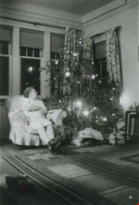
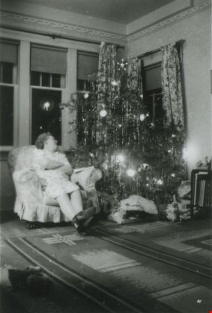
Ida Le Grove beside a Christmas Tree
https://search.heritageburnaby.ca/link/archivedescription38070
- Repository
- City of Burnaby Archives
- Date
- Dec. 1943 (date of original), copied 1991
- Collection/Fonds
- Burnaby Historical Society fonds
- Description Level
- Item
- Physical Description
- 1 photograph : b&w ; 4.3 x 2.9 cm print on contact sheet 20.2 x 26.2 cm
- Scope and Content
- Photograph of Ida Le Grove seated in a chair beside a Christmas tree at 2224 Antrim Avenue (later renumbered 6957 Antrim Avenue).
- Repository
- City of Burnaby Archives
- Date
- Dec. 1943 (date of original), copied 1991
- Collection/Fonds
- Burnaby Historical Society fonds
- Subseries
- Burnaby Image Bank subseries
- Physical Description
- 1 photograph : b&w ; 4.3 x 2.9 cm print on contact sheet 20.2 x 26.2 cm
- Description Level
- Item
- Record No.
- 370-657
- Access Restriction
- No restrictions
- Reproduction Restriction
- No known restrictions
- Accession Number
- BHS1999-03
- Scope and Content
- Photograph of Ida Le Grove seated in a chair beside a Christmas tree at 2224 Antrim Avenue (later renumbered 6957 Antrim Avenue).
- Subjects
- Holidays - Christmas
- Names
- Le Grove, Ida
- Media Type
- Photograph
- Notes
- Title based on contents of photograph
- 1 b&w copy negative accompanying
- Negative has a pink cast
- Geographic Access
- Antrim Avenue
- Street Address
- 6957 Antrim Avenue
- Historic Neighbourhood
- Central Park (Historic Neighbourhood)
- Planning Study Area
- Windsor Area
Images
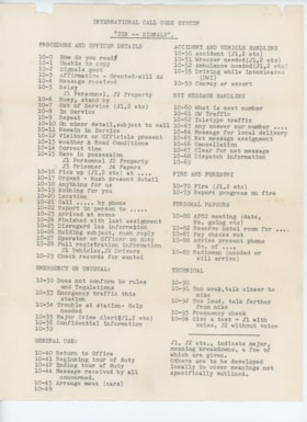
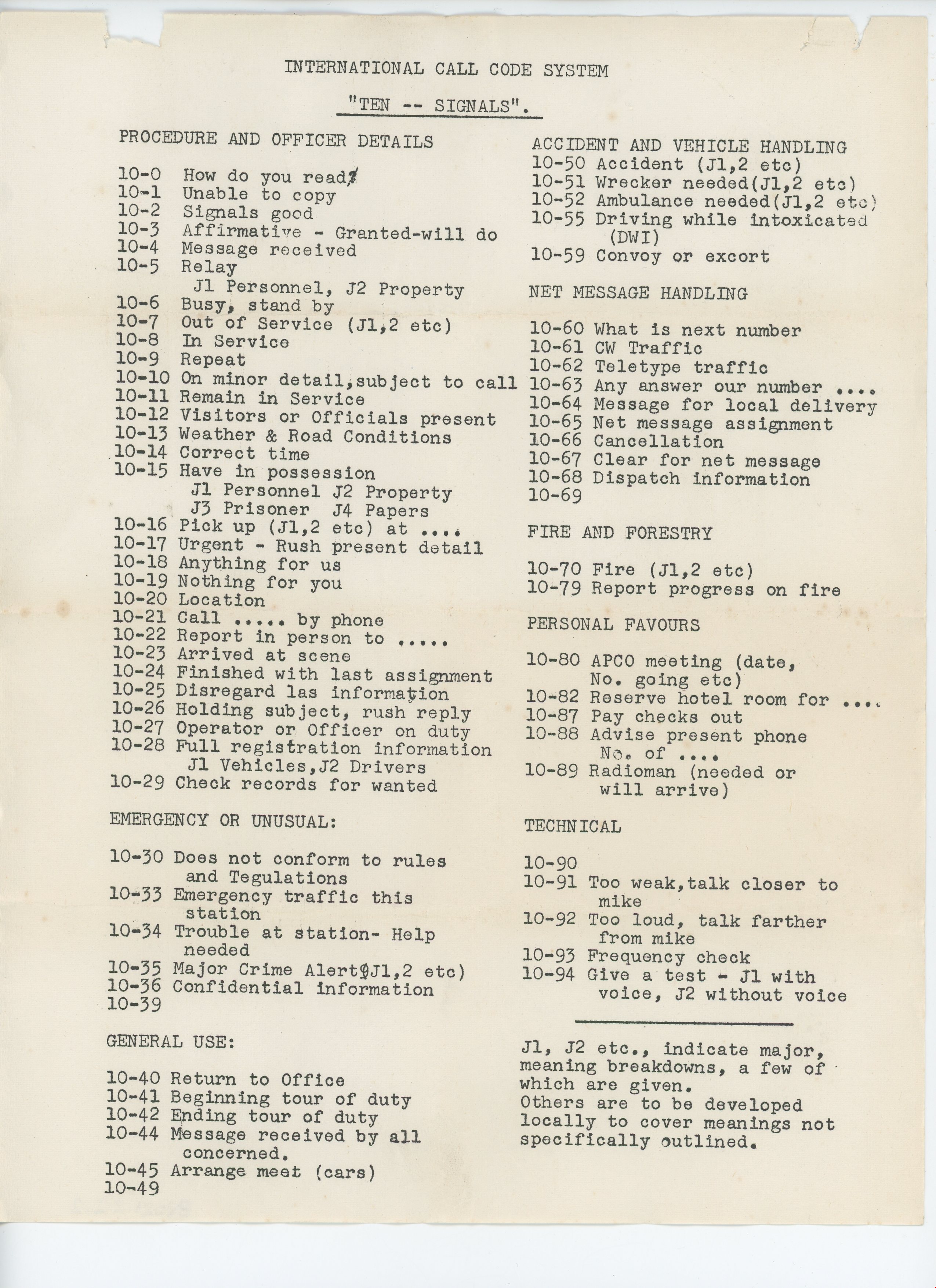
international call codes paper
https://search.heritageburnaby.ca/link/museumartifact91450
- Repository
- Burnaby Village Museum
- Accession Code
- BV021.22.2
- Description
- Paper listing several radio signals used by the Civil Defense department. Paper is creased and yellowing especially around edges and folds.
- Object History
- This “Ten – Signals” paper was donated alongside the audio-amplification set, belonging to Mr. Edward Fountain. The signals represented on the paper were used in training volunteers in the Burnaby Civil Defence Department, of which Mr. Fountain was named Director/ Coordinator in 1952. The Burnaby Civil Defense Department was established in order to disseminate information guiding the public on how to react in response to the impending threat of nuclear war and Russian bombers. In the early 1950’s, this education centered primarily on evacuation, as members of the public were expected to prepare and essentially fend for themselves in the event of a nuclear attack. Training took place throughout the City of Burnaby and in the surrounding regions, as the Civil Defence departments of several municipalities (namely the City of Vancouver and the City of New Westminster) partnered together in evacuation and recovery training, where the use of instructional training papers such as this would come into play.
- Category
- 08. Communication Artifacts
- Classification
- Visual Communication T&E
- Object Term
- Paperwork
- Colour
- White
- Measurements
- height: 28.2 cm width: 22 cm
- Subjects
- Communication Artifacts
- Names
- Fountain, Edward
- Geographic Access
- Burnaby Lake
- Planning Study Area
- Windsor Area
Images
![Jack Cole, Anne Le Grove and Ida Le Grove, [1944] (date of original), copied 1991 thumbnail](/media/hpo/_Data/_Archives_Images/_Unrestricted/370/370-614.jpg?width=280)
Jack Cole, Anne Le Grove and Ida Le Grove
https://search.heritageburnaby.ca/link/archivedescription38027
- Repository
- City of Burnaby Archives
- Date
- [1944] (date of original), copied 1991
- Collection/Fonds
- Burnaby Historical Society fonds
- Description Level
- Item
- Physical Description
- 1 photograph : b&w ; 2.6 x 3.4 cm print on contact sheet 20.6 x 26.3 cm
- Scope and Content
- Photograph of (left to right) Jack Cole, baby Anne Le Grove and Ida Le Grove outside of 2224 Antrim Avenue (later renumbered 6957 Antrim Avenue). Laundry can be seen on the line in the upper left of the photo.
- Repository
- City of Burnaby Archives
- Date
- [1944] (date of original), copied 1991
- Collection/Fonds
- Burnaby Historical Society fonds
- Subseries
- Burnaby Image Bank subseries
- Physical Description
- 1 photograph : b&w ; 2.6 x 3.4 cm print on contact sheet 20.6 x 26.3 cm
- Description Level
- Item
- Record No.
- 370-614
- Access Restriction
- No restrictions
- Reproduction Restriction
- No known restrictions
- Accession Number
- BHS1999-03
- Scope and Content
- Photograph of (left to right) Jack Cole, baby Anne Le Grove and Ida Le Grove outside of 2224 Antrim Avenue (later renumbered 6957 Antrim Avenue). Laundry can be seen on the line in the upper left of the photo.
- Media Type
- Photograph
- Notes
- Title based on contents of photograph
- 1 b&w copy negative accompanying
- Negative has a pink cast
- Geographic Access
- Antrim Avenue
- Street Address
- 6957 Antrim Avenue
- Historic Neighbourhood
- Central Park (Historic Neighbourhood)
- Planning Study Area
- Windsor Area
Images
![Jack Cole, Anne Le Grove and Ida Le Grove, [1944] (date of original), copied 1991 thumbnail](/media/hpo/_Data/_Archives_Images/_Unrestricted/370/370-614.jpg)
James McMahon
https://search.heritageburnaby.ca/link/archivedescription35257
- Repository
- City of Burnaby Archives
- Date
- 1923 (date of original), copied 1986
- Collection/Fonds
- Burnaby Historical Society fonds
- Description Level
- Item
- Physical Description
- 1 photograph : b&w ; 12.7 x 17.8 cm print
- Scope and Content
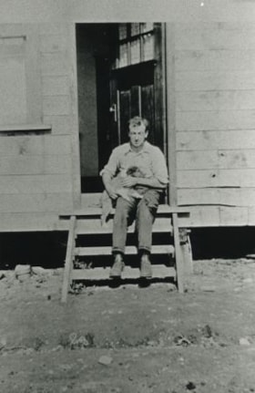
- Photograph of James McMahon on the front steps of the house he built at 2691 Waltham Avenue with a dog in his arms (later renumbered 6658 Waltham Avenue).
- Repository
- City of Burnaby Archives
- Date
- 1923 (date of original), copied 1986
- Collection/Fonds
- Burnaby Historical Society fonds
- Subseries
- Pioneer Tales subseries
- Physical Description
- 1 photograph : b&w ; 12.7 x 17.8 cm print
- Description Level
- Item
- Record No.
- 204-114
- Access Restriction
- No restrictions
- Reproduction Restriction
- No known restrictions
- Accession Number
- BHS1988-03
- Scope and Content
- Photograph of James McMahon on the front steps of the house he built at 2691 Waltham Avenue with a dog in his arms (later renumbered 6658 Waltham Avenue).
- Subjects
- Animals - Dogs
- Names
- McMahon, James
- Media Type
- Photograph
- Notes
- Title based on contents of photograph
- Geographic Access
- Waltham Avenue
- Street Address
- 6558 Waltham Avenue
- Historic Neighbourhood
- Central Park (Historic Neighbourhood)
- Planning Study Area
- Windsor Area
Images

![James Smith house, [1907] thumbnail](/media/hpo/_Data/_Archives_Images/_Unrestricted/126/137-001.jpg?width=280)
James Smith house
https://search.heritageburnaby.ca/link/archivedescription34808
- Repository
- City of Burnaby Archives
- Date
- [1907]
- Collection/Fonds
- Burnaby Historical Society fonds
- Description Level
- Item
- Physical Description
- 1 photograph : b&w ; 10.0 x 14.0 cm mounted on 17.7 x 22.cm cardboard
- Scope and Content
- Photograph of the exterior of the James Smith house, 6186 Royal Oak Avenue. A woman and two girls are seated on the porch stairs. The accession description states that the house is a B.C. Mills Prefab erected in 1907 by Mr. and Mrs. Smith.
- Repository
- City of Burnaby Archives
- Date
- [1907]
- Collection/Fonds
- Burnaby Historical Society fonds
- Subseries
- Grace Pletcher subseries
- Physical Description
- 1 photograph : b&w ; 10.0 x 14.0 cm mounted on 17.7 x 22.cm cardboard
- Description Level
- Item
- Record No.
- 137-001
- Access Restriction
- No restrictions
- Reproduction Restriction
- No known restrictions
- Accession Number
- BHS1985-06
- Scope and Content
- Photograph of the exterior of the James Smith house, 6186 Royal Oak Avenue. A woman and two girls are seated on the porch stairs. The accession description states that the house is a B.C. Mills Prefab erected in 1907 by Mr. and Mrs. Smith.
- Subjects
- Buildings - Residential - Houses
- Media Type
- Photograph
- Notes
- Title based on contents of photograph
- Annotations on the back of the cardboard read, "With love from Agnes" and "Mrs H Rolfe / Charles Rd. / South Portland / Maine."
- Geographic Access
- Royal Oak Avenue
- Street Address
- 6186 Royal Oak Avenue
- Historic Neighbourhood
- Central Park (Historic Neighbourhood)
- Planning Study Area
- Windsor Area
Images
![James Smith house, [1907] thumbnail](/media/hpo/_Data/_Archives_Images/_Unrestricted/126/137-001.jpg)

Jim Pattison Courtesy Chevrolet
https://search.heritageburnaby.ca/link/archivedescription79252
- Repository
- City of Burnaby Archives
- Date
- October 9, 1976
- Collection/Fonds
- Burnaby Public Library Contemporary Visual Archive Project
- Description Level
- Item
- Physical Description
- 1 photograph : b&w ; 11 x 16 cm mounted on cardboard
- Scope and Content
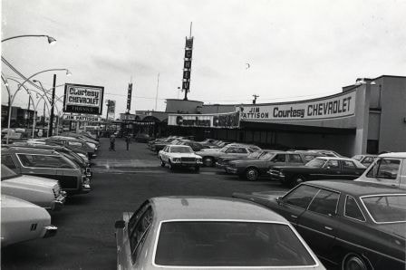
- Photograph shows cars in the lot of the Jim Pattison Courtesy Chevrolet at 5405 Kingsway. The building was originally Dueck's and was built in 1958 by Thompson, Berwick and Pratt.
- Repository
- City of Burnaby Archives
- Date
- October 9, 1976
- Collection/Fonds
- Burnaby Public Library Contemporary Visual Archive Project
- Physical Description
- 1 photograph : b&w ; 11 x 16 cm mounted on cardboard
- Description Level
- Item
- Record No.
- 556-222
- Access Restriction
- No restrictions
- Reproduction Restriction
- Reproduce for fair dealing purposes only
- Accession Number
- 2013-13
- Scope and Content
- Photograph shows cars in the lot of the Jim Pattison Courtesy Chevrolet at 5405 Kingsway. The building was originally Dueck's and was built in 1958 by Thompson, Berwick and Pratt.
- Media Type
- Photograph
- Photographer
- McCarron, John
- Notes
- Scope note taken directly from BPL photograph description.
- 1 b&w copy negative : 10 x 12.5 cm accompanying
- Geographic Access
- Kingsway
- Street Address
- 5405 Kingsway
- Historic Neighbourhood
- Central Park (Historic Neighbourhood)
- Planning Study Area
- Windsor Area
Images
Kejac's Steak and Burger Pit
https://search.heritageburnaby.ca/link/archivedescription79324
- Repository
- City of Burnaby Archives
- Date
- October 9, 1976
- Collection/Fonds
- Burnaby Public Library Contemporary Visual Archive Project
- Description Level
- Item
- Physical Description
- 1 photograph : b&w ; 11 x 16 cm mounted on cardboard
- Scope and Content
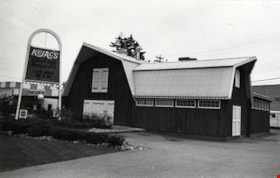
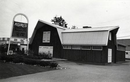
- Photograph shows Kejac's Steak and Burger Pit at 6040 Kingsway. It was originally called the Red Barn.
- Repository
- City of Burnaby Archives
- Date
- October 9, 1976
- Collection/Fonds
- Burnaby Public Library Contemporary Visual Archive Project
- Physical Description
- 1 photograph : b&w ; 11 x 16 cm mounted on cardboard
- Description Level
- Item
- Record No.
- 556-240
- Access Restriction
- No restrictions
- Reproduction Restriction
- Reproduce for fair dealing purposes only
- Accession Number
- 2013-13
- Scope and Content
- Photograph shows Kejac's Steak and Burger Pit at 6040 Kingsway. It was originally called the Red Barn.
- Subjects
- Buildings - Commercial - Restaurants
- Media Type
- Photograph
- Photographer
- McCarron, John
- Notes
- Scope note taken directly from BPL photograph description.
- 1 b&w copy negative : 10 x 12.5 cm accompanying
- Geographic Access
- Kingsway
- Street Address
- 6040 Kingsway
- Planning Study Area
- Windsor Area
Images

Kingcrest Animal Hospital
https://search.heritageburnaby.ca/link/archivedescription93693
- Repository
- City of Burnaby Archives
- Date
- June 4, 1978
- Collection/Fonds
- Burnaby Public Library Contemporary Visual Archive Project
- Description Level
- Item
- Physical Description
- 1 photograph : b&w ; 12.5 x 17.5 cm
- Scope and Content
- Photograph of the parking lot and exterior of a single-storey building with a sign advertising the Kingcrest Animal Hospital, located at Kingsway and Sperling. The photograph is taken from across the street, facing south.
- Repository
- City of Burnaby Archives
- Date
- June 4, 1978
- Collection/Fonds
- Burnaby Public Library Contemporary Visual Archive Project
- Physical Description
- 1 photograph : b&w ; 12.5 x 17.5 cm
- Description Level
- Item
- Record No.
- 556-650
- Access Restriction
- No restrictions
- Reproduction Restriction
- Reproduce for fair dealing purposes only
- Accession Number
- 2017-57
- Scope and Content
- Photograph of the parking lot and exterior of a single-storey building with a sign advertising the Kingcrest Animal Hospital, located at Kingsway and Sperling. The photograph is taken from across the street, facing south.
- Subjects
- Buildings - Commercial
- Media Type
- Photograph
- Photographer
- Chapman, Fred
- Notes
- Title taken from project information form
- Accompanied by a project information form and 1 photograph (b&w negative ; 9.5 x 12.5 cm)
- BPL no. 98
- Geographic Access
- Kingsway
- Sperling Avenue
- Historic Neighbourhood
- Edmonds (Historic Neighbourhood)
- Planning Study Area
- Windsor Area
Images


Kingsview Apartments
https://search.heritageburnaby.ca/link/archivedescription98669
- Repository
- City of Burnaby Archives
- Date
- 2022
- Collection/Fonds
- Disappearing Burnaby collection
- Description Level
- Item
- Physical Description
- 1 photograph (jpeg) : col.
- Scope and Content
- Photograph of the entrance and exterior of Kingsview Apartments, an apartment building located at 6187 Kingsway. The photograph depicts the building at night and in the rain. The hallways and stairwells of the three-storey apartment building are illuminated. The building was constructed in 1977.
- Repository
- City of Burnaby Archives
- Date
- 2022
- Collection/Fonds
- Disappearing Burnaby collection
- Physical Description
- 1 photograph (jpeg) : col.
- Description Level
- Item
- Record No.
- 634-016
- Access Restriction
- No restrictions
- Reproduction Restriction
- No restrictions
- Accession Number
- 2022-14
- Scope and Content
- Photograph of the entrance and exterior of Kingsview Apartments, an apartment building located at 6187 Kingsway. The photograph depicts the building at night and in the rain. The hallways and stairwells of the three-storey apartment building are illuminated. The building was constructed in 1977.
- Media Type
- Photograph
- Photographer
- Cheung, Nakita
- Notes
- Title taken from the associated blog post
- Associated blog post: https://disappearingburnaby.wordpress.com/2022/06/01/oasis/
- Geographic Access
- Kingsway
- Street Address
- 6187 Kingsway
- Historic Neighbourhood
- Central Park (Historic Neighbourhood)
- Planning Study Area
- Windsor Area
Images

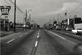
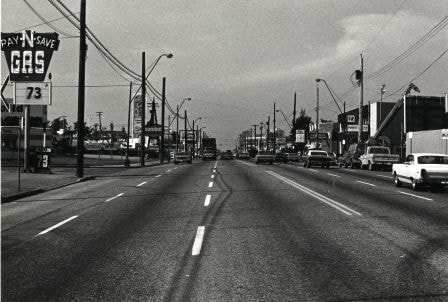
Kingsway
https://search.heritageburnaby.ca/link/archivedescription79986
- Repository
- City of Burnaby Archives
- Date
- September 10, 1976
- Collection/Fonds
- Burnaby Public Library Contemporary Visual Archive Project
- Description Level
- Item
- Physical Description
- 1 photograph : b&w ; 11 x 16 cm mounted on cardboard
- Scope and Content
- Photograph shows the view looking northwest along the 5500 block of Kingsway.
- Repository
- City of Burnaby Archives
- Date
- September 10, 1976
- Collection/Fonds
- Burnaby Public Library Contemporary Visual Archive Project
- Physical Description
- 1 photograph : b&w ; 11 x 16 cm mounted on cardboard
- Description Level
- Item
- Record No.
- 556-542
- Access Restriction
- No restrictions
- Reproduction Restriction
- Reproduce for fair dealing purposes only
- Accession Number
- 2013-13
- Scope and Content
- Photograph shows the view looking northwest along the 5500 block of Kingsway.
- Media Type
- Photograph
- Photographer
- Norton, Paul
- Notes
- Scope note taken directly from BPL photograph description.
- 1 b&w copy negative : 10 x 12.5 cm accompanying
- Geographic Access
- Kingsway
- Planning Study Area
- Windsor Area
Images

Kingsway
https://search.heritageburnaby.ca/link/landmark775
- Repository
- Burnaby Heritage Planning
- Associated Dates
- 1913
- Heritage Value
- The years 1911-1912 saw great expansion and settlement in Burnaby and large public works projects were undertaken to service the growing community. One project that was determined to be a necessity was the construction of a proper highway between New Westminster and Vancouver. The Province and the Municipality agreed to share the costs of construction (with Burnaby paying 25% and the Province 75%) and so Kingsway was built to improve the current Vancouver Road. The road was named after the famous King's Way in London, England.
- Historic Neighbourhood
- Central Park (Historic Neighbourhood)
- Edmonds (Historic Neighbourhood)
- Planning Study Area
- Maywood Area
- Marlborough Area
- Windsor Area
- Kingsway-Beresford Area
- Stride Avenue Area
- Edmonds Area
Images

![Kingsway, [1914] thumbnail](/media/hpo/_Data/_BVM_Images/1971/197200110022.jpg?width=280)
Kingsway
https://search.heritageburnaby.ca/link/museumdescription3108
- Repository
- Burnaby Village Museum
- Date
- [1914]
- Collection/Fonds
- Burnaby Village Museum Photograph collection
- Description Level
- Item
- Physical Description
- 1 photograph : b&w glass negative ; 15.8 x 21.1 cm
- Scope and Content
- Photograph of a paved street lined on both sides with curbs and electric poles. There appears to be a car in the distance, as well as an idustrial building on the right-hand side of the road. An earlier catalogue record from 1988 conjectures that the street is Kingsway, probably in Burnaby, between…
- Repository
- Burnaby Village Museum
- Collection/Fonds
- Burnaby Village Museum Photograph collection
- Description Level
- Item
- Physical Description
- 1 photograph : b&w glass negative ; 15.8 x 21.1 cm
- Scope and Content
- Photograph of a paved street lined on both sides with curbs and electric poles. There appears to be a car in the distance, as well as an idustrial building on the right-hand side of the road. An earlier catalogue record from 1988 conjectures that the street is Kingsway, probably in Burnaby, between Sperling Avenue and Royal Oak, looking South, and that the building is possibly the Macadam making plant for the company which paved Kingsway.
- Subjects
- Geographic Features - Roads
- Geographic Access
- Kingsway
- Sperling Avenue
- Royal Oak Avenue
- Accession Code
- HV972.11.22
- Access Restriction
- No restrictions
- Reproduction Restriction
- No known restrictions
- Date
- [1914]
- Media Type
- Photograph
- Planning Study Area
- Windsor Area
- Scan Resolution
- 300
- Scan Date
- 14/8/2006
- Scale
- 100
- Notes
- Title based on contents of photograph
- 1 b&w contact print accompanying negative
Images
![Kingsway, [1914] thumbnail](/media/hpo/_Data/_BVM_Images/1971/197200110022.jpg)