Narrow Results By
5200 Oakmount Cr.
https://search.heritageburnaby.ca/link/archivedescription94313
- Repository
- City of Burnaby Archives
- Date
- June 1994
- Collection/Fonds
- Grover, Elliott & Co. Ltd. fonds
- Description Level
- File
- Physical Description
- 23 photographs : col. negatives ; 35 mm
- Scope and Content
- Photographs of an undeveloped property located at 5200 Oakmount Crescent - an address that no longer exists.
- Repository
- City of Burnaby Archives
- Date
- June 1994
- Collection/Fonds
- Grover, Elliott & Co. Ltd. fonds
- Physical Description
- 23 photographs : col. negatives ; 35 mm
- Description Level
- File
- Record No.
- 622-098
- Access Restriction
- No restrictions
- Reproduction Restriction
- No restrictions
- Accession Number
- 2017-39
- Scope and Content
- Photographs of an undeveloped property located at 5200 Oakmount Crescent - an address that no longer exists.
- Subjects
- Land Clearing
- Media Type
- Photograph
- Notes
- Transcribed title
- Title transcribed from envelope photographs were originally housed in
- File no. 94-236-B
- Photographer identified as "J.C."
- Geographic Access
- Oakmount Crescent
- Historic Neighbourhood
- Central Park (Historic Neighbourhood)
- Planning Study Area
- Windsor Area
5608-5628 Imperial Street
https://search.heritageburnaby.ca/link/archivedescription94343
- Repository
- City of Burnaby Archives
- Date
- July 1995
- Collection/Fonds
- Grover, Elliott & Co. Ltd. fonds
- Description Level
- File
- Physical Description
- 25 photographs : col. negatives ; 35 mm
- Scope and Content
- Photographs of the commerical buildings located along the 5600 block of Imperial Street and the intersection at Imperial Street and Macpherson Avenue.
- Repository
- City of Burnaby Archives
- Date
- July 1995
- Collection/Fonds
- Grover, Elliott & Co. Ltd. fonds
- Physical Description
- 25 photographs : col. negatives ; 35 mm
- Description Level
- File
- Record No.
- 622-128
- Access Restriction
- No restrictions
- Reproduction Restriction
- No restrictions
- Accession Number
- 2017-39
- Scope and Content
- Photographs of the commerical buildings located along the 5600 block of Imperial Street and the intersection at Imperial Street and Macpherson Avenue.
- Media Type
- Photograph
- Notes
- Transcribed title
- Title transcribed from envelope photographs were originally housed in
- File no. 95-263-B
- Geographic Access
- Imperial Street
- MacPherson Avenue
- Street Address
- 5608 Imperial Street
- 5628 Imperial Street
- Historic Neighbourhood
- Central Park (Historic Neighbourhood)
- Planning Study Area
- Windsor Area
7050 Buller Ave
https://search.heritageburnaby.ca/link/archivedescription93884
- Repository
- City of Burnaby Archives
- Date
- March 1993
- Collection/Fonds
- Grover, Elliott & Co. Ltd. fonds
- Description Level
- File
- Physical Description
- 25 photographs : col. negatives ; 35 mm
- Scope and Content
- Photographs of an industrial building located at 7050 Buller Avenue taken from Buller Avenue and Beresford Street.
- Repository
- City of Burnaby Archives
- Date
- March 1993
- Collection/Fonds
- Grover, Elliott & Co. Ltd. fonds
- Physical Description
- 25 photographs : col. negatives ; 35 mm
- Description Level
- File
- Record No.
- 622-067
- Access Restriction
- No restrictions
- Reproduction Restriction
- No restrictions
- Accession Number
- 2017-39
- Scope and Content
- Photographs of an industrial building located at 7050 Buller Avenue taken from Buller Avenue and Beresford Street.
- Media Type
- Photograph
- Photographer
- Young, Richard
- Notes
- Transcribed title
- Title transcribed from envelope photographs were originally housed in
- File no. 93-109-B
- Geographic Access
- Buller Avenue
- Beresford Street
- Street Address
- 7050 Buller Avenue
- Planning Study Area
- Windsor Area
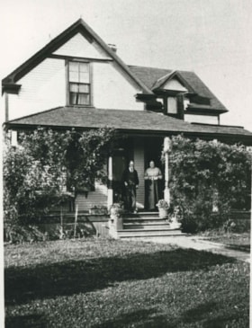
![James Smith house, [1907] thumbnail](/media/hpo/_Data/_Archives_Images/_Unrestricted/126/137-001.jpg?width=280)
James Smith house
https://search.heritageburnaby.ca/link/archivedescription34808
- Repository
- City of Burnaby Archives
- Date
- [1907]
- Collection/Fonds
- Burnaby Historical Society fonds
- Description Level
- Item
- Physical Description
- 1 photograph : b&w ; 10.0 x 14.0 cm mounted on 17.7 x 22.cm cardboard
- Scope and Content
- Photograph of the exterior of the James Smith house, 6186 Royal Oak Avenue. A woman and two girls are seated on the porch stairs. The accession description states that the house is a B.C. Mills Prefab erected in 1907 by Mr. and Mrs. Smith.
- Repository
- City of Burnaby Archives
- Date
- [1907]
- Collection/Fonds
- Burnaby Historical Society fonds
- Subseries
- Grace Pletcher subseries
- Physical Description
- 1 photograph : b&w ; 10.0 x 14.0 cm mounted on 17.7 x 22.cm cardboard
- Description Level
- Item
- Record No.
- 137-001
- Access Restriction
- No restrictions
- Reproduction Restriction
- No known restrictions
- Accession Number
- BHS1985-06
- Scope and Content
- Photograph of the exterior of the James Smith house, 6186 Royal Oak Avenue. A woman and two girls are seated on the porch stairs. The accession description states that the house is a B.C. Mills Prefab erected in 1907 by Mr. and Mrs. Smith.
- Subjects
- Buildings - Residential - Houses
- Media Type
- Photograph
- Notes
- Title based on contents of photograph
- Annotations on the back of the cardboard read, "With love from Agnes" and "Mrs H Rolfe / Charles Rd. / South Portland / Maine."
- Geographic Access
- Royal Oak Avenue
- Street Address
- 6186 Royal Oak Avenue
- Historic Neighbourhood
- Central Park (Historic Neighbourhood)
- Planning Study Area
- Windsor Area
Images
![James Smith house, [1907] thumbnail](/media/hpo/_Data/_Archives_Images/_Unrestricted/126/137-001.jpg)
![Lancelot Grimmer house, [1905] thumbnail](/media/hpo/_Data/_Archives_Images/_Unrestricted/251/290-001.jpg?width=280)
Lancelot Grimmer house
https://search.heritageburnaby.ca/link/archivedescription36531
- Repository
- City of Burnaby Archives
- Date
- [1905]
- Collection/Fonds
- Burnaby Historical Society fonds
- Description Level
- Item
- Physical Description
- 1 photograph : b&w ; 9 x 13 cm print
- Scope and Content
- Photograph of Martha Jane, Irene & Cynthia (Martha Jane's sister) Grimmer standing on the front porch of the Lancelot and Martha Jane Grimmer House.
- Repository
- City of Burnaby Archives
- Date
- [1905]
- Collection/Fonds
- Burnaby Historical Society fonds
- Subseries
- Grimmer family subseries
- Physical Description
- 1 photograph : b&w ; 9 x 13 cm print
- Description Level
- Item
- Record No.
- 290-001
- Access Restriction
- No restrictions
- Reproduction Restriction
- No known restrictions
- Accession Number
- BHS1992-26
- Scope and Content
- Photograph of Martha Jane, Irene & Cynthia (Martha Jane's sister) Grimmer standing on the front porch of the Lancelot and Martha Jane Grimmer House.
- Subjects
- Buildings - Residential - Houses
- Media Type
- Photograph
- Notes
- Title based on contents of photograph
- Geographic Access
- Grimmer Street
- Historic Neighbourhood
- Central Park (Historic Neighbourhood)
- Planning Study Area
- Windsor Area
Images
![Lancelot Grimmer house, [1905] thumbnail](/media/hpo/_Data/_Archives_Images/_Unrestricted/251/290-001.jpg)
![Police officer at Royal Oak and Kingsway, [1999] thumbnail](/media/hpo/_Data/_Archives_Images/_Unrestricted/535/535-3258.jpg?width=280)
Police officer at Royal Oak and Kingsway
https://search.heritageburnaby.ca/link/archivedescription98180
- Repository
- City of Burnaby Archives
- Date
- [1999]
- Collection/Fonds
- Burnaby NewsLeader photograph collection
- Description Level
- Item
- Physical Description
- 1 photograph (tiff) : col.
- Scope and Content
- Photograph of a Burnaby RCMP officer wearing a reflective vest and standing on the sidewalk by a bus stop on Kingsway, across the street from a Safeway, at the intersection of Royal Oak Avenue and Kingsway.
- Repository
- City of Burnaby Archives
- Date
- [1999]
- Collection/Fonds
- Burnaby NewsLeader photograph collection
- Physical Description
- 1 photograph (tiff) : col.
- Description Level
- Item
- Record No.
- 535-3258
- Access Restriction
- No restrictions
- Reproduction Restriction
- No restrictions
- Accession Number
- 2018-12
- Scope and Content
- Photograph of a Burnaby RCMP officer wearing a reflective vest and standing on the sidewalk by a bus stop on Kingsway, across the street from a Safeway, at the intersection of Royal Oak Avenue and Kingsway.
- Subjects
- Occupations - Police Officers
- Geographic Features - Roads
- Buildings - Commercial - Grocery Stores
- Media Type
- Photograph
- Notes
- Title based on contents of photograph
- Collected by editorial for use in a July 1999 issue of the Burnaby NewsLeader
- Geographic Access
- Kingsway
- Royal Oak Avenue
- Historic Neighbourhood
- Central Park (Historic Neighbourhood)
- Planning Study Area
- Windsor Area
Images
![Police officer at Royal Oak and Kingsway, [1999] thumbnail](/media/hpo/_Data/_Archives_Images/_Unrestricted/535/535-3258.jpg)
Tidball-Cram family home
https://search.heritageburnaby.ca/link/archivedescription35605
- Repository
- City of Burnaby Archives
- Date
- 1908 (date of original), copied 1986
- Collection/Fonds
- Burnaby Historical Society fonds
- Description Level
- Item
- Physical Description
- 1 photograph : b&w ; 12.7 x 17.8 cm print
- Scope and Content
- Photograph of the Tidball-Cram family home, 3267Kingsway (later renumbered 5489 Kingsway) at Denbigh Avenue (Denbigh did not exist at the time; the area was the family's orchard). Grandfather Tidball (left) and Grandmother Tidball (right) are on the porch. The Tidball's daughter and son-in-law, Ali…
- Repository
- City of Burnaby Archives
- Date
- 1908 (date of original), copied 1986
- Collection/Fonds
- Burnaby Historical Society fonds
- Subseries
- Pioneer Tales subseries
- Physical Description
- 1 photograph : b&w ; 12.7 x 17.8 cm print
- Description Level
- Item
- Record No.
- 204-463
- Access Restriction
- No restrictions
- Reproduction Restriction
- No known restrictions
- Accession Number
- BHS1988-03
- Scope and Content
- Photograph of the Tidball-Cram family home, 3267Kingsway (later renumbered 5489 Kingsway) at Denbigh Avenue (Denbigh did not exist at the time; the area was the family's orchard). Grandfather Tidball (left) and Grandmother Tidball (right) are on the porch. The Tidball's daughter and son-in-law, Alice and William Cram, and their family joined the Tidballs on their farm after moving to Burnaby from the United States. The Crams and Tidballs produced and sold fruit, produce, honey, and cottage cheese.
- Subjects
- Buildings - Residential - Houses
- Media Type
- Photograph
- Notes
- Title based on contents of photograph
- Geographic Access
- Kingsway
- Street Address
- 5489 Kingsway
- Historic Neighbourhood
- Central Park (Historic Neighbourhood)
- Planning Study Area
- Windsor Area
Images


Windsor Neighbourhood
https://search.heritageburnaby.ca/link/landmark803
- Repository
- Burnaby Heritage Planning
- Associated Dates
- 1955-2008
- Heritage Value
- The Windsor Neighbourhood comprises a number of different districts with different characteristics. To the north, stretching to the border of the Deer Lake Park, is the primarily residential area that was developed after the building boom of the 1950s and now consists of a mix of single-family and multi-family housing. To the south, from Kingsway to the Skytrain line, an industrial area was maintained along with a significant commercial corridor along Kingsway. In recent years, the growth and development of this area has been guided by the Royal Oak Community Plan adopted by Council in 1999.
- Planning Study Area
- Windsor Area
Images
