Narrow Results By
Subject
- Advertising Medium - Signs and Signboards 6
- Aerial Photographs 1
- Agriculture - Farms 2
- Agriculture - Fruit and Berries 2
- Animals - Cows 1
- Animals - Dogs 3
- Animals - Goats 2
- Animals - Poultry 3
- Building Components 8
- Buildings - Agricultural 1
- Buildings - Agricultural - Barns 1
- Buildings - Agricultural - Greenhouses 2
Creator
- Bartel, Mario 4
- Bellinger, Bernard 11
- Bowman & Cullerne 1
- British Columbia Underwriters' Association 3
- Chapman, Fred 1
- Cheung, Nakita 3
- Dominion Photo Company 1
- Henderson, Norman M. "Norm" 1
- McCarron, John 5
- Norton, Paul 10
- Plan Department, British Columbia Insurance Underwriters' Association 3
- Printed on back of postcard: "Pub. by Living Colour Advertising Agencies, 809 21st St., New West'r, BC - 526-6612" and "Made in Canada / Dexter Color, Canada Ltd., Cornwall, Ontario" 1
Burnaby South Secondary School yearbook : 1926-1927
https://search.heritageburnaby.ca/link/museumlibrary7509
- Repository
- Burnaby Village Museum
- Collection
- Special Collection
- Material Type
- Book
- Accession Code
- BV020.7.2
- Call Number
- 373.71 BUR 1927
- Place of Publication
- Burnaby, B.C.
- Publisher
- Burnaby South Secondary School
- Publication Date
- 1927
- Printer
- Lionel Ward & Co. Ltd.
- Library Subject (LOC)
- School yearbooks--1920-1929
- Schools--British Columbia--Burnaby
- School yearbooks
- Historic Neighbourhood
- Central Park (Historic Neighbourhood)
- Planning Study Area
- Windsor Area
- Geographic Access
- Rumble Street
- Street Address
- 5455 Rumble Street
- Object History
- This yearbook belonged to Lauretta Roberts.
- Notes
- High school annual for Burnaby South
Sellers family home
https://search.heritageburnaby.ca/link/archivedescription35237
- Repository
- City of Burnaby Archives
- Date
- 1928 (date of original), copied 1986
- Collection/Fonds
- Burnaby Historical Society fonds
- Description Level
- Item
- Physical Description
- 1 photograph : b&w ; 12.7 x 17.8 cm print
- Scope and Content
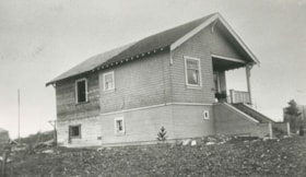
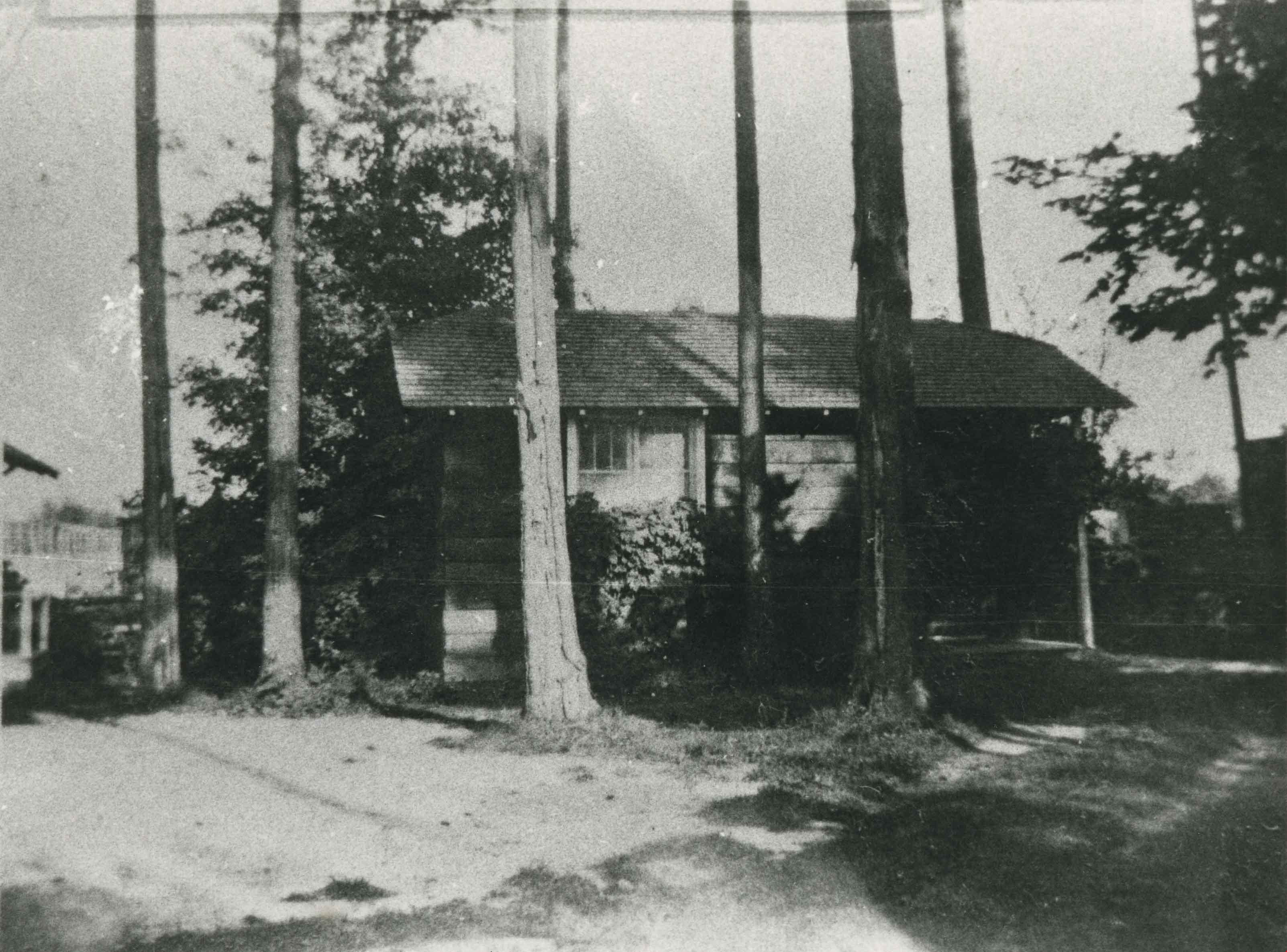
- Photograph of the completed Sellers family home at 3130 Princess Street (later 5680 Lane Street) which was finished in 1928. The home was built by Harry Sellers from 1923-1928. The family lived in the front portion while still working on the rest of the house.
- Repository
- City of Burnaby Archives
- Date
- 1928 (date of original), copied 1986
- Collection/Fonds
- Burnaby Historical Society fonds
- Subseries
- Pioneer Tales subseries
- Physical Description
- 1 photograph : b&w ; 12.7 x 17.8 cm print
- Description Level
- Item
- Record No.
- 204-094
- Access Restriction
- No restrictions
- Reproduction Restriction
- No known restrictions
- Accession Number
- BHS1988-03
- Scope and Content
- Photograph of the completed Sellers family home at 3130 Princess Street (later 5680 Lane Street) which was finished in 1928. The home was built by Harry Sellers from 1923-1928. The family lived in the front portion while still working on the rest of the house.
- Subjects
- Buildings - Residential - Houses
- Media Type
- Photograph
- Notes
- Title based on contents of photograph
- Geographic Access
- Lane Street
- Street Address
- 5680 Lane Street
- Historic Neighbourhood
- Central Park (Historic Neighbourhood)
- Planning Study Area
- Windsor Area
Images

McMahon chickens
https://search.heritageburnaby.ca/link/archivedescription35261
- Repository
- City of Burnaby Archives
- Date
- 1928 (date of original), copied 1986
- Collection/Fonds
- Burnaby Historical Society fonds
- Description Level
- Item
- Physical Description
- 1 photograph : b&w ; 12.7 x 17.8 cm print
- Scope and Content
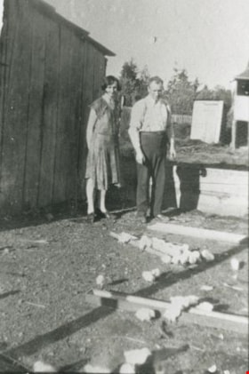
- Photograph of baby chicks on the McMahon property on Waltham Avenue, later numbered 6558 Waltham Avenue. A woman and man are standing behind them.
- Repository
- City of Burnaby Archives
- Date
- 1928 (date of original), copied 1986
- Collection/Fonds
- Burnaby Historical Society fonds
- Subseries
- Pioneer Tales subseries
- Physical Description
- 1 photograph : b&w ; 12.7 x 17.8 cm print
- Description Level
- Item
- Record No.
- 204-118
- Access Restriction
- No restrictions
- Reproduction Restriction
- No known restrictions
- Accession Number
- BHS1988-03
- Scope and Content
- Photograph of baby chicks on the McMahon property on Waltham Avenue, later numbered 6558 Waltham Avenue. A woman and man are standing behind them.
- Subjects
- Animals - Poultry
- Media Type
- Photograph
- Notes
- Title based on contents of photograph
- Geographic Access
- Waltham Avenue
- Street Address
- 6558 Waltham Avenue
- Historic Neighbourhood
- Central Park (Historic Neighbourhood)
- Planning Study Area
- Windsor Area
Images


Painting Centre Line on Kingsway
https://search.heritageburnaby.ca/link/museumdescription65
- Repository
- Burnaby Village Museum
- Date
- 1928 (date of original), copied 1971
- Collection/Fonds
- Burnaby Village Museum Photograph collection
- Description Level
- Item
- Physical Description
- 1 photograph : b&w ; 15.0 x 25.2 cm print
- Scope and Content
- Photograph of Frank Warburton sitting backwards on a plank attached to the front of a car, as it is being driven. The make of the car is unidentified, but has wooden spoked wheels, running boards, and a soft convertible top. Mr. Warburton is painting the centre line on Kingsway. The photograph is…
- Repository
- Burnaby Village Museum
- Collection/Fonds
- Burnaby Village Museum Photograph collection
- Description Level
- Item
- Physical Description
- 1 photograph : b&w ; 15.0 x 25.2 cm print
- Scope and Content
- Photograph of Frank Warburton sitting backwards on a plank attached to the front of a car, as it is being driven. The make of the car is unidentified, but has wooden spoked wheels, running boards, and a soft convertible top. Mr. Warburton is painting the centre line on Kingsway. The photograph is taken 1928 at corner of Grimmer and Kingsway. In the background of the photograph, to the left, there are residential houses with a parked car, and to the right, is a tall gas pump.
- Names
- Warburton, Frank
- Geographic Access
- Kingsway
- Grimmer Street
- Accession Code
- HV971.173.1
- Access Restriction
- No restrictions
- Reproduction Restriction
- No known restrictions
- Date
- 1928 (date of original), copied 1971
- Media Type
- Photograph
- Historic Neighbourhood
- Central Park (Historic Neighbourhood)
- Planning Study Area
- Windsor Area
- Scan Resolution
- 600
- Scan Date
- 2023-03-28
- Notes
- Title based on contents of photograph
- The information in scope and content taken from earlier catalgue record from 1976, and verified by various accession and donation paperworks
Images

Burnaby South Secondary School yearbook : 1927-1928
https://search.heritageburnaby.ca/link/museumlibrary5328
- Repository
- Burnaby Village Museum
- Collection
- Special Collection
- Material Type
- Book
- Accession Code
- BV005.79.1
- Call Number
- 373.71 BUR 1928
- Place of Publication
- Burnaby, B.C.
- Publisher
- Burnaby South Secondary School
- Publication Date
- 1928
- Printer
- Lionel Ward & Co. Ltd.
- Physical Description
- 48 p. : ill., ports. ; 16 x 23 cm.
- Library Subject (LOC)
- School yearbooks--1920-1929
- Schools--British Columbia--Burnaby
- School yearbooks
- Historic Neighbourhood
- Central Park (Historic Neighbourhood)
- Planning Study Area
- Windsor Area
- Geographic Access
- Rumble Street
- Street Address
- 5455 Rumble Street
- Notes
- High school annual for South Burnaby High School
Bellinger and Baker children
https://search.heritageburnaby.ca/link/archivedescription35166
- Repository
- City of Burnaby Archives
- Date
- 1929 (date of original), copied 1986
- Collection/Fonds
- Burnaby Historical Society fonds
- Description Level
- Item
- Physical Description
- 1 photograph : b&w ; 12.7 x 17.8 cm print
- Scope and Content
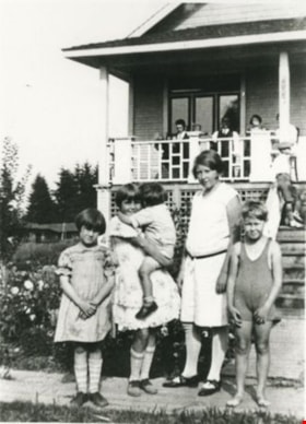
- Photograph of Bellinger children and friends. From left: Marion Bellinger, Christine Bellinger holding Robert "Bob" Bellinger, and two Baker children. Taken in front of Bellinger home at 6296 Earl Avenue, now called Pearl Avenue. Note the plank sidewalk.
- Repository
- City of Burnaby Archives
- Date
- 1929 (date of original), copied 1986
- Collection/Fonds
- Burnaby Historical Society fonds
- Subseries
- Pioneer Tales subseries
- Physical Description
- 1 photograph : b&w ; 12.7 x 17.8 cm print
- Description Level
- Item
- Record No.
- 204-023
- Access Restriction
- No restrictions
- Reproduction Restriction
- No known restrictions
- Accession Number
- BHS1988-03
- Scope and Content
- Photograph of Bellinger children and friends. From left: Marion Bellinger, Christine Bellinger holding Robert "Bob" Bellinger, and two Baker children. Taken in front of Bellinger home at 6296 Earl Avenue, now called Pearl Avenue. Note the plank sidewalk.
- Media Type
- Photograph
- Notes
- Title based on contents of photograph
- Geographic Access
- Pearl Avenue
- Street Address
- 6296 Earl Avenue
- Historic Neighbourhood
- Central Park (Historic Neighbourhood)
- Planning Study Area
- Windsor Area
Images

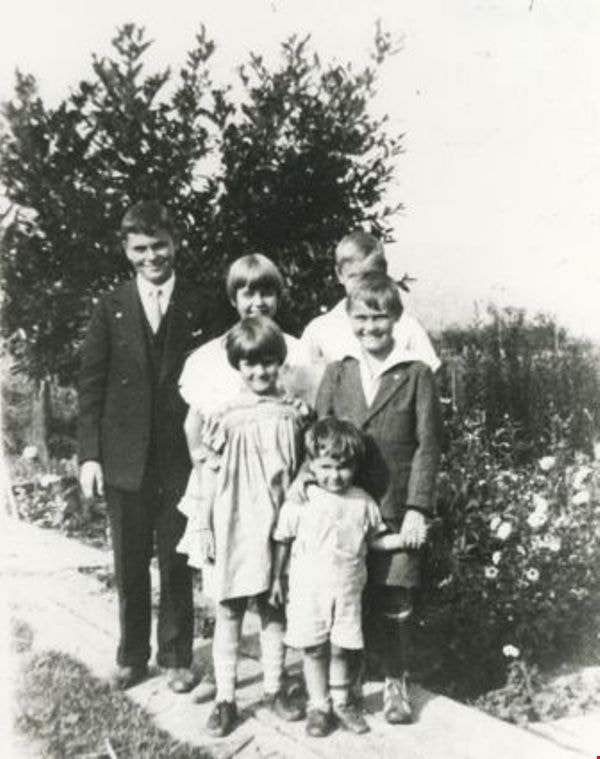
Bellinger family
https://search.heritageburnaby.ca/link/archivedescription35167
- Repository
- City of Burnaby Archives
- Date
- 1929 (date of original), copied 1986
- Collection/Fonds
- Burnaby Historical Society fonds
- Description Level
- Item
- Physical Description
- 1 photograph : b&w ; 12.7 x 17.8 cm print
- Scope and Content
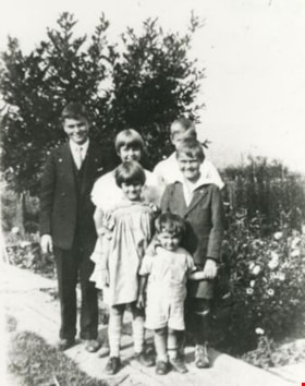
- Photograph of the Bellinger family children. Back row: Bernard Bellinger, Christine Bellinger and David Bellinger. Middle row: Marion Bellinger and James Bellinger. Front row: Robert "Bob" Bellinger. Taken in front of the Bellinger family home at 6296 Earl Avenue, now called Pearl Avenue.
- Repository
- City of Burnaby Archives
- Date
- 1929 (date of original), copied 1986
- Collection/Fonds
- Burnaby Historical Society fonds
- Subseries
- Pioneer Tales subseries
- Physical Description
- 1 photograph : b&w ; 12.7 x 17.8 cm print
- Description Level
- Item
- Record No.
- 204-024
- Access Restriction
- No restrictions
- Reproduction Restriction
- No known restrictions
- Accession Number
- BHS1988-03
- Scope and Content
- Photograph of the Bellinger family children. Back row: Bernard Bellinger, Christine Bellinger and David Bellinger. Middle row: Marion Bellinger and James Bellinger. Front row: Robert "Bob" Bellinger. Taken in front of the Bellinger family home at 6296 Earl Avenue, now called Pearl Avenue.
- Names
- Bellinger, Bernard
- Bellinger, Christine
- Bellinger, David
- Bellinger, James
- Bellinger, Marion
- Bellinger, Robert "Bob"
- Media Type
- Photograph
- Notes
- Title based on contents of photograph
- Geographic Access
- Pearl Avenue
- Street Address
- 6296 Earl Avenue
- Historic Neighbourhood
- Central Park (Historic Neighbourhood)
- Planning Study Area
- Windsor Area
Images

Florence McMahon
https://search.heritageburnaby.ca/link/archivedescription35262
- Repository
- City of Burnaby Archives
- Date
- 1929 (date of original), copied 1986
- Collection/Fonds
- Burnaby Historical Society fonds
- Description Level
- Item
- Physical Description
- 1 photograph : b&w ; 12.7 x 17.8 cm print
- Scope and Content
- Photograph of Florence McMahon, daughter of Florence Bookey McMahon and James McMahon, wearing beach pyjamas, the fashion of the day. She is feeding pet ducks who were hatched by the hen in the background. She is on the McMahon property on Waltham Avenue, later numbered 6558 Waltham Avenue.
- Repository
- City of Burnaby Archives
- Date
- 1929 (date of original), copied 1986
- Collection/Fonds
- Burnaby Historical Society fonds
- Subseries
- Pioneer Tales subseries
- Physical Description
- 1 photograph : b&w ; 12.7 x 17.8 cm print
- Description Level
- Item
- Record No.
- 204-119
- Access Restriction
- No restrictions
- Reproduction Restriction
- No known restrictions
- Accession Number
- BHS1988-03
- Scope and Content
- Photograph of Florence McMahon, daughter of Florence Bookey McMahon and James McMahon, wearing beach pyjamas, the fashion of the day. She is feeding pet ducks who were hatched by the hen in the background. She is on the McMahon property on Waltham Avenue, later numbered 6558 Waltham Avenue.
- Subjects
- Clothing
- Animals - Poultry
- Names
- McMahon, Florence
- Media Type
- Photograph
- Notes
- Title based on contents of photograph
- Geographic Access
- Waltham Avenue
- Street Address
- 6558 Waltham Avenue
- Historic Neighbourhood
- Central Park (Historic Neighbourhood)
- Planning Study Area
- Windsor Area
Images

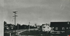
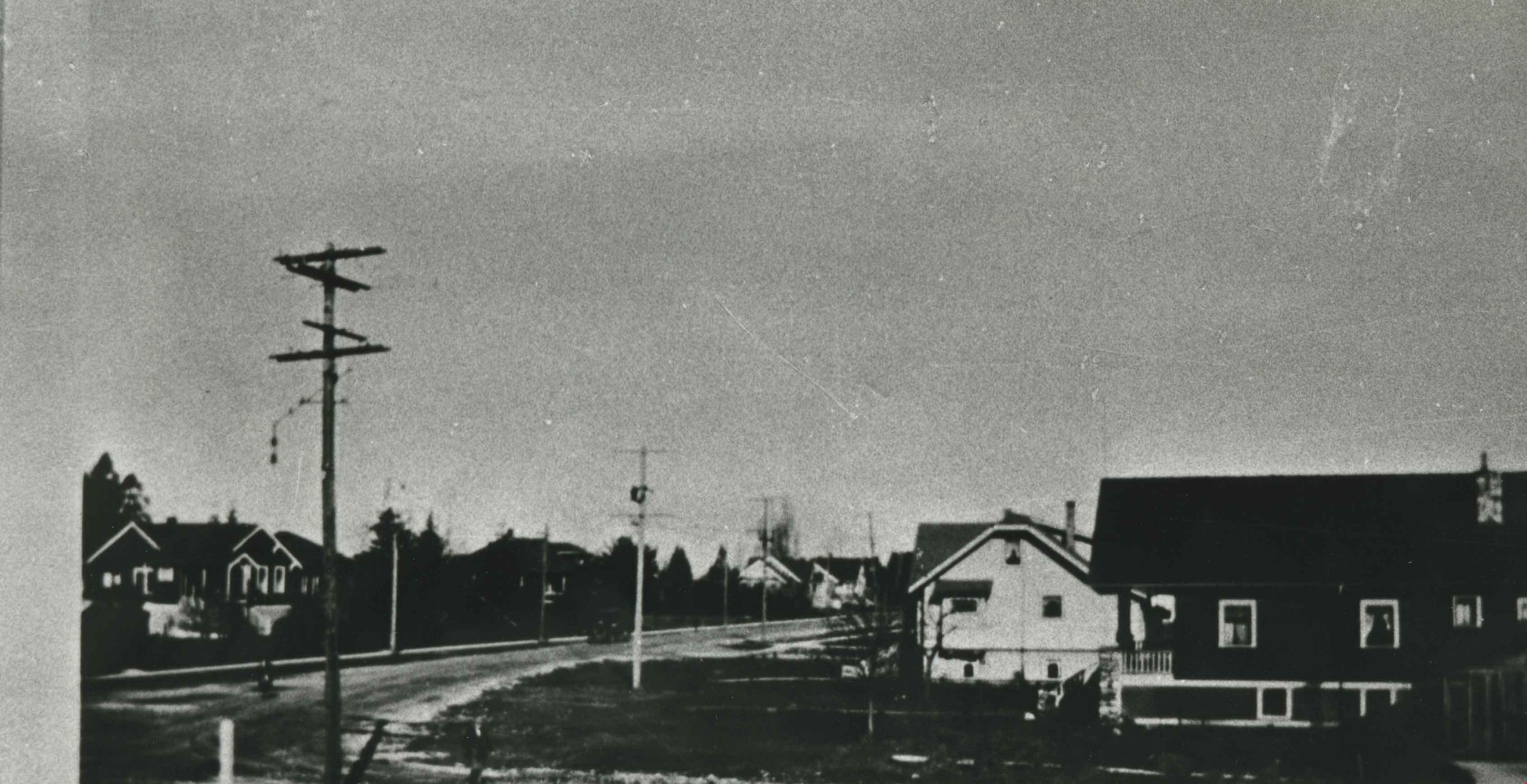
Davis family neighbourhood
https://search.heritageburnaby.ca/link/archivedescription35610
- Repository
- City of Burnaby Archives
- Date
- 1929 (date of original), copied 1986
- Collection/Fonds
- Burnaby Historical Society fonds
- Description Level
- Item
- Physical Description
- 1 photograph : b&w ; 10.2 x 17.8 cm print
- Scope and Content
- Photograph of the neighbourhood where the Davis family lived, looking up Royal Oak Road at Imperial Street, taken from an upstairs room of the Davis home. Arthur Davis later built a corner house at 2345 Royal Oak, right next to house from which this photograph was taken.
- Repository
- City of Burnaby Archives
- Date
- 1929 (date of original), copied 1986
- Collection/Fonds
- Burnaby Historical Society fonds
- Subseries
- Pioneer Tales subseries
- Physical Description
- 1 photograph : b&w ; 10.2 x 17.8 cm print
- Description Level
- Item
- Record No.
- 204-468
- Access Restriction
- No restrictions
- Reproduction Restriction
- No known restrictions
- Accession Number
- BHS1988-03
- Scope and Content
- Photograph of the neighbourhood where the Davis family lived, looking up Royal Oak Road at Imperial Street, taken from an upstairs room of the Davis home. Arthur Davis later built a corner house at 2345 Royal Oak, right next to house from which this photograph was taken.
- Subjects
- Geographic Features - Neighbourhoods
- Media Type
- Photograph
- Notes
- Title based on contents of photograph
- Photograph has been cropped
- Geographic Access
- Royal Oak Avenue
- Historic Neighbourhood
- Central Park (Historic Neighbourhood)
- Planning Study Area
- Windsor Area
Images
Oasis Tourist Camp cabins
https://search.heritageburnaby.ca/link/archivedescription35627
- Repository
- City of Burnaby Archives
- Date
- 1929 (date of original), copied 1986
- Collection/Fonds
- Burnaby Historical Society fonds
- Description Level
- Item
- Physical Description
- 1 photograph : b&w ; 12.7 x 17.8 cm print
- Scope and Content
- Photograph of the first of ten rental cabins built at The Oasis tourist camp. The Oasis was located at 2675 Kingsway (Pacific Highway). It was later renumbered 6105 Kingsway.
- Repository
- City of Burnaby Archives
- Date
- 1929 (date of original), copied 1986
- Collection/Fonds
- Burnaby Historical Society fonds
- Subseries
- Pioneer Tales subseries
- Physical Description
- 1 photograph : b&w ; 12.7 x 17.8 cm print
- Description Level
- Item
- Record No.
- 204-485
- Access Restriction
- No restrictions
- Reproduction Restriction
- No known restrictions
- Accession Number
- BHS1988-03
- Scope and Content
- Photograph of the first of ten rental cabins built at The Oasis tourist camp. The Oasis was located at 2675 Kingsway (Pacific Highway). It was later renumbered 6105 Kingsway.
- Names
- Oasis
- Media Type
- Photograph
- Notes
- Title based on contents of photograph
- Geographic Access
- Kingsway
- Street Address
- 6105 Kingsway
- Planning Study Area
- Windsor Area
Images
![Bellinger and Baker children, [1929 or 1930] (date of original), copied 1991 thumbnail](/media/hpo/_Data/_Archives_Images/_Unrestricted/370/370-063.jpg?width=280)
Bellinger and Baker children
https://search.heritageburnaby.ca/link/archivedescription37475
- Repository
- City of Burnaby Archives
- Date
- [1929 or 1930] (date of original), copied 1991
- Collection/Fonds
- Burnaby Historical Society fonds
- Description Level
- Item
- Physical Description
- 1 photograph : b&w ; 4.4 x 3.0 cm print on contact sheet 20.2 x 25.3 cm
- Scope and Content
- Photograph of five children standing on the board sidewalk in front of 2827 Earl Avenue (later 6296 Pearl Avenue). Left to right: Marion Bellinger, Christine Bellinger, Robert Bellinger, Barbara Baker, and Barbara's sister. Adults are seated on the porch behind them.
- Repository
- City of Burnaby Archives
- Date
- [1929 or 1930] (date of original), copied 1991
- Collection/Fonds
- Burnaby Historical Society fonds
- Subseries
- Burnaby Image Bank subseries
- Physical Description
- 1 photograph : b&w ; 4.4 x 3.0 cm print on contact sheet 20.2 x 25.3 cm
- Description Level
- Item
- Record No.
- 370-063
- Access Restriction
- No restrictions
- Reproduction Restriction
- Reproduce for fair dealing purposes only
- Accession Number
- BHS1999-03
- Scope and Content
- Photograph of five children standing on the board sidewalk in front of 2827 Earl Avenue (later 6296 Pearl Avenue). Left to right: Marion Bellinger, Christine Bellinger, Robert Bellinger, Barbara Baker, and Barbara's sister. Adults are seated on the porch behind them.
- Media Type
- Photograph
- Photographer
- Bellinger, Bernard
- Notes
- Title based on contents of photograph
- 1 b&w copy negative accompanying
- Geographic Access
- Pearl Avenue
- Street Address
- 6296 Pearl Avenue
- Historic Neighbourhood
- Central Park (Historic Neighbourhood)
- Planning Study Area
- Windsor Area
Images
![Bellinger and Baker children, [1929 or 1930] (date of original), copied 1991 thumbnail](/media/hpo/_Data/_Archives_Images/_Unrestricted/370/370-063.jpg)
Burnaby South Secondary School yearbook : 1928-1929
https://search.heritageburnaby.ca/link/museumlibrary5329
- Repository
- Burnaby Village Museum
- Collection
- Special Collection
- Material Type
- Book
- Accession Code
- BV005.79.2
- Call Number
- 373.71 BUR 1929
- Place of Publication
- Burnaby, B.C.
- Publisher
- Burnaby South Secondary School
- Publication Date
- 1929
- Printer
- Ward & Phillips
- Physical Description
- 59 p. : ill., ports. ; 26 cm.
- Library Subject (LOC)
- School yearbooks--1920-1929
- Schools--British Columbia--Burnaby
- School yearbooks
- Historic Neighbourhood
- Central Park (Historic Neighbourhood)
- Planning Study Area
- Windsor Area
- Geographic Access
- Rumble Street
- Street Address
- 5455 Rumble Street
- Notes
- High school annual for South Burnaby High School

Burnaby South Secondary School yearbook : 1928-1929
https://search.heritageburnaby.ca/link/museumlibrary7510
- Repository
- Burnaby Village Museum
- Collection
- Special Collection
- Material Type
- Book
- Accession Code
- BV020.7.3
- Call Number
- 373.71 BUR 1929
- Place of Publication
- Burnaby, B.C.
- Publisher
- Burnaby South Secondary School
- Publication Date
- 1929
- Printer
- Ward & Phillips
- Physical Description
- 60 p. : ill., ports. ; 26 cm.
- Library Subject (LOC)
- School yearbooks--1920-1929
- Schools--British Columbia--Burnaby
- School yearbooks
- Historic Neighbourhood
- Central Park (Historic Neighbourhood)
- Planning Study Area
- Windsor Area
- Geographic Access
- Rumble Street
- Street Address
- 5455 Rumble Street
- Object History
- This yearbook belonged to Lauretta Roberts.
- Notes
- High school annual for South Burnaby High School
Images

![Elgin Avenue, [193-] (date of original), copied 1986 thumbnail](/media/hpo/_Data/_Archives_Images/_Unrestricted/126/179-004.jpg?width=280)
Elgin Avenue
https://search.heritageburnaby.ca/link/archivedescription35033
- Repository
- City of Burnaby Archives
- Date
- [193-] (date of original), copied 1986
- Collection/Fonds
- Burnaby Historical Society fonds
- Description Level
- Item
- Physical Description
- 1 photograph : b&w ; 8.8 x 12.7 cm print
- Scope and Content
- Photograph of Elgin Avenue looking North from a farm at 6389 Elgin Avenue. Trees and brush line the road.
- Repository
- City of Burnaby Archives
- Date
- [193-] (date of original), copied 1986
- Collection/Fonds
- Burnaby Historical Society fonds
- Subseries
- Chamberlain family subseries
- Physical Description
- 1 photograph : b&w ; 8.8 x 12.7 cm print
- Description Level
- Item
- Record No.
- 179-004
- Access Restriction
- No restrictions
- Reproduction Restriction
- No known restrictions
- Accession Number
- BHS1986-27
- Scope and Content
- Photograph of Elgin Avenue looking North from a farm at 6389 Elgin Avenue. Trees and brush line the road.
- Subjects
- Geographic Features - Roads
- Media Type
- Photograph
- Notes
- Title based on contents of photograph
- Geographic Access
- Elgin Avenue
- Street Address
- 6389 Elgin Avenue
- Historic Neighbourhood
- Central Park (Historic Neighbourhood)
- Planning Study Area
- Windsor Area
Images
![Elgin Avenue, [193-] (date of original), copied 1986 thumbnail](/media/hpo/_Data/_Archives_Images/_Unrestricted/126/179-004.jpg)
![Thould's dinky store, [1930] (date of original), copied 1986 thumbnail](/media/hpo/_Data/_Archives_Images/_Unrestricted/204/204-006.jpg?width=280)
Thould's dinky store
https://search.heritageburnaby.ca/link/archivedescription35149
- Repository
- City of Burnaby Archives
- Date
- [1930] (date of original), copied 1986
- Collection/Fonds
- Burnaby Historical Society fonds
- Description Level
- Item
- Physical Description
- 1 photograph : b&w ; 12.7 x 17.8 cm print
- Scope and Content
- Photograph of Grace (nee Dommet) and Lionel "Judge" Thould's "dinky" store at Highland Park Interurban station on the Central Park Interurban line.
- Repository
- City of Burnaby Archives
- Date
- [1930] (date of original), copied 1986
- Collection/Fonds
- Burnaby Historical Society fonds
- Subseries
- Pioneer Tales subseries
- Physical Description
- 1 photograph : b&w ; 12.7 x 17.8 cm print
- Description Level
- Item
- Record No.
- 204-006
- Access Restriction
- No restrictions
- Reproduction Restriction
- No known restrictions
- Accession Number
- BHS1988-03
- Scope and Content
- Photograph of Grace (nee Dommet) and Lionel "Judge" Thould's "dinky" store at Highland Park Interurban station on the Central Park Interurban line.
- Subjects
- Buildings - Commercial - Stores
- Buildings - Commercial - Train Stations
- Transportation - Electric Railroads
- Media Type
- Photograph
- Notes
- Title based on contents of photograph
- Geographic Access
- Buller Avenue
- Central Park Interurban line
- Beresford Street
- Planning Study Area
- Windsor Area
Images
![Thould's dinky store, [1930] (date of original), copied 1986 thumbnail](/media/hpo/_Data/_Archives_Images/_Unrestricted/204/204-006.jpg)

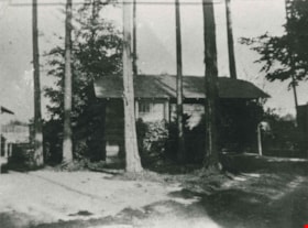
Williamson family home
https://search.heritageburnaby.ca/link/archivedescription35404
- Repository
- City of Burnaby Archives
- Date
- 1930 (date of original), copied 1986
- Collection/Fonds
- Burnaby Historical Society fonds
- Description Level
- Item
- Physical Description
- 1 photograph : b&w ; 12.7 x 17.8 cm print
- Scope and Content
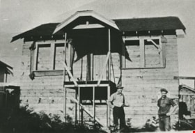
- Photograph of the completed Williamson family home at 6965 Antrim Avenue. Pictured (left to right) Marjorie Williamson and Elsie Williamson, daughters of Mr. Williamson and Mrs. Minnie Williamson, who built the home.
- Repository
- City of Burnaby Archives
- Date
- 1930 (date of original), copied 1986
- Collection/Fonds
- Burnaby Historical Society fonds
- Subseries
- Pioneer Tales subseries
- Physical Description
- 1 photograph : b&w ; 12.7 x 17.8 cm print
- Description Level
- Item
- Record No.
- 204-261
- Access Restriction
- No restrictions
- Reproduction Restriction
- No known restrictions
- Accession Number
- BHS1988-03
- Scope and Content
- Photograph of the completed Williamson family home at 6965 Antrim Avenue. Pictured (left to right) Marjorie Williamson and Elsie Williamson, daughters of Mr. Williamson and Mrs. Minnie Williamson, who built the home.
- Subjects
- Toys - Dolls
- Media Type
- Photograph
- Notes
- Title based on contents of photograph
- Geographic Access
- Antrim Avenue
- Street Address
- 6965 Antrim Avenue
- Historic Neighbourhood
- Central Park (Historic Neighbourhood)
- Planning Study Area
- Windsor Area
Images

![Central Park Interurban trams, [1930] (date of original), copied 1986 thumbnail](/media/hpo/_Data/_Archives_Images/_Unrestricted/204/204-370.jpg?width=280)
Central Park Interurban trams
https://search.heritageburnaby.ca/link/archivedescription35512
- Repository
- City of Burnaby Archives
- Date
- [1930] (date of original), copied 1986
- Collection/Fonds
- Burnaby Historical Society fonds
- Description Level
- Item
- Physical Description
- 1 photograph : b&w ; 12.7 x 17.8 cm print
- Scope and Content
- Photograph of Central Park Interurban trams at Royal Oak Station. Jimmy Strachan, the motorman, is not visible.
- Repository
- City of Burnaby Archives
- Date
- [1930] (date of original), copied 1986
- Collection/Fonds
- Burnaby Historical Society fonds
- Subseries
- Pioneer Tales subseries
- Physical Description
- 1 photograph : b&w ; 12.7 x 17.8 cm print
- Description Level
- Item
- Record No.
- 204-370
- Access Restriction
- No restrictions
- Reproduction Restriction
- No known restrictions
- Accession Number
- BHS1988-03
- Scope and Content
- Photograph of Central Park Interurban trams at Royal Oak Station. Jimmy Strachan, the motorman, is not visible.
- Media Type
- Photograph
- Notes
- Title based on contents of photograph
- Geographic Access
- Central Park Interurban line
- Historic Neighbourhood
- Central Park (Historic Neighbourhood)
- Planning Study Area
- Windsor Area
Images
![Central Park Interurban trams, [1930] (date of original), copied 1986 thumbnail](/media/hpo/_Data/_Archives_Images/_Unrestricted/204/204-370.jpg)
![Cram family, [193-] (date of original), copied 1986 thumbnail](/media/hpo/_Data/_Archives_Images/_Unrestricted/204/204-568.jpg?width=280)
Cram family
https://search.heritageburnaby.ca/link/archivedescription35710
- Repository
- City of Burnaby Archives
- Date
- [193-] (date of original), copied 1986
- Collection/Fonds
- Burnaby Historical Society fonds
- Description Level
- Item
- Physical Description
- 1 photograph : b&w ; 12.7 x 17.8 cm print
- Scope and Content
- Photograph of the Cram family. Back row, left to right: Jean Cram (sister), Viola Cram (sister), William Cram (father), Mrs. Alice Tidball Cram (mother). Front, left to right: Ruth Cram (sister) and Tom Cram (brother). This photograph was taken in front of the family home at Kingsway and what is …
- Repository
- City of Burnaby Archives
- Date
- [193-] (date of original), copied 1986
- Collection/Fonds
- Burnaby Historical Society fonds
- Subseries
- Pioneer Tales subseries
- Physical Description
- 1 photograph : b&w ; 12.7 x 17.8 cm print
- Description Level
- Item
- Record No.
- 204-568
- Access Restriction
- No restrictions
- Reproduction Restriction
- No known restrictions
- Accession Number
- BHS1988-03
- Scope and Content
- Photograph of the Cram family. Back row, left to right: Jean Cram (sister), Viola Cram (sister), William Cram (father), Mrs. Alice Tidball Cram (mother). Front, left to right: Ruth Cram (sister) and Tom Cram (brother). This photograph was taken in front of the family home at Kingsway and what is now 6515 Denbigh Avenue.
- Media Type
- Photograph
- Notes
- Title based on contents of photograph
- Geographic Access
- Denbigh Avenue
- Street Address
- 6515 Denbigh Avenue
- Historic Neighbourhood
- Central Park (Historic Neighbourhood)
- Planning Study Area
- Windsor Area
Images
![Cram family, [193-] (date of original), copied 1986 thumbnail](/media/hpo/_Data/_Archives_Images/_Unrestricted/204/204-568.jpg)
Rigby family home
https://search.heritageburnaby.ca/link/archivedescription35778
- Repository
- City of Burnaby Archives
- Date
- 1930 (date of original), copied 1986
- Collection/Fonds
- Burnaby Historical Society fonds
- Description Level
- Item
- Physical Description
- 1 photograph : b&w ; 12.7 x 17.8 cm print
- Scope and Content
- Photograph of the Rigby family home at 2319 Alder Avenue (later renumbered and renambed 6908 Palm Avenue) in South Burnaby. Identified: (right, wearing cap) Joe Rigby (husband of Edna Armitage). He built this house for his bride after buying a 200 x 50 foot lot for $200, $15 down. The Rigby chil…
- Repository
- City of Burnaby Archives
- Date
- 1930 (date of original), copied 1986
- Collection/Fonds
- Burnaby Historical Society fonds
- Subseries
- Pioneer Tales subseries
- Physical Description
- 1 photograph : b&w ; 12.7 x 17.8 cm print
- Description Level
- Item
- Record No.
- 204-636
- Access Restriction
- No restrictions
- Reproduction Restriction
- No known restrictions
- Accession Number
- BHS1988-03
- Scope and Content
- Photograph of the Rigby family home at 2319 Alder Avenue (later renumbered and renambed 6908 Palm Avenue) in South Burnaby. Identified: (right, wearing cap) Joe Rigby (husband of Edna Armitage). He built this house for his bride after buying a 200 x 50 foot lot for $200, $15 down. The Rigby children, Joe and Doreen, were raised here.
- Subjects
- Buildings - Residential - Houses
- Media Type
- Photograph
- Notes
- Title based on contents of photograph
- Geographic Access
- Palm Avenue
- Street Address
- 6908 Palm Avenue
- Historic Neighbourhood
- Central Park (Historic Neighbourhood)
- Planning Study Area
- Windsor Area
Images

![Bellinger family garden, [1930] (date of original), copied 1991 thumbnail](/media/hpo/_Data/_Archives_Images/_Unrestricted/370/370-053.jpg?width=280)
Bellinger family garden
https://search.heritageburnaby.ca/link/archivedescription37465
- Repository
- City of Burnaby Archives
- Date
- [1930] (date of original), copied 1991
- Collection/Fonds
- Burnaby Historical Society fonds
- Description Level
- Item
- Physical Description
- 1 photograph : b&w ; 3.8 x 2.9 cm print on contact sheet 20.2 x 25.3 cm
- Scope and Content
- Photograph of the Bellinger family back garden at 2827 Earl Avenue (later 6296 Pearl Avenue), with vegetables and a chicken coop at the back right.
- Repository
- City of Burnaby Archives
- Date
- [1930] (date of original), copied 1991
- Collection/Fonds
- Burnaby Historical Society fonds
- Subseries
- Burnaby Image Bank subseries
- Physical Description
- 1 photograph : b&w ; 3.8 x 2.9 cm print on contact sheet 20.2 x 25.3 cm
- Description Level
- Item
- Record No.
- 370-053
- Access Restriction
- No restrictions
- Reproduction Restriction
- No known restrictions
- Accession Number
- BHS1999-03
- Scope and Content
- Photograph of the Bellinger family back garden at 2827 Earl Avenue (later 6296 Pearl Avenue), with vegetables and a chicken coop at the back right.
- Subjects
- Geographic Features - Gardens
- Media Type
- Photograph
- Photographer
- Bellinger, Bernard
- Notes
- Title based on contents of photograph
- 1 b&w copy negative accompanying
- Geographic Access
- Pearl Avenue
- Street Address
- 6296 Pearl Avenue
- Historic Neighbourhood
- Central Park (Historic Neighbourhood)
- Planning Study Area
- Windsor Area
Images
![Bellinger family garden, [1930] (date of original), copied 1991 thumbnail](/media/hpo/_Data/_Archives_Images/_Unrestricted/370/370-053.jpg)