Narrow Results By
Subject
- Agriculture - Farms 1
- Agriculture - Fruit and Berries 3
- Animals - Horses 1
- Artifacts 1
- Arts 4
- Buildings - Commercial 1
- Buildings - Commercial - Stores 2
- Buildings - Heritage 1
- Buildings - Public - Detention Facilities 1
- Buildings - Residential 1
- Buildings - Residential - Houses 4
- Buildings - Residential - Seniors Housing 1
Creator
- Alter, Ian 1
- Ashmore, Sidney G. (Sidney Gillespie), 1852-1911 1
- Bateman, Caroline Mary Wettenhall 1
- Battistoni, Peter 4
- Braid, Tom 3
- Burnaby Village Museum 8
- City of Burnaby 1
- Collins, Robert, 1924- 1
- Corsbie, Joseph Hardcastle-Cumberland "Joe" 1
- Damer, Eric 2
- Duffield, C. G. (Charles George) 1
- Ehlers, Edith "Edie" Fleming 1
South Africa and the Boer-British War : comprising a history of South Africa and its people, including the War of 1899 and 1900
https://search.heritageburnaby.ca/link/museumlibrary508
- Repository
- Burnaby Village Museum
- Collection
- Special Collection
- Material Type
- Book
- Accession Code
- BV986.53.15
- Call Number
- 968.2 CAS
- Place of Publication
- Toronto
- Publisher
- John C. Winston
- Publication Date
- c1900
- Physical Description
- xii, 25-448 p. [64] p. of plates : ill., ports. ; 24 cm.
- Library Subject (LOC)
- South African War, 1899-1902
- South Africa--History
- Notes
- "in two volumes"--T.p.
- Author's given name: Hopkins, J. Castell (John Castell), 1864-1923
Caesar's Helvetian war : adapted for the use of beginners
https://search.heritageburnaby.ca/link/museumlibrary7063
- Repository
- Burnaby Village Museum
- Collection
- Special Collection
- Material Type
- Book
- Accession Code
- BV018.11.15
- Call Number
- 878 WEL
- Edition
- New ed.
- Contributor
- Ashmore, Sidney G. (Sidney Gillespie), 1852-1911
- Place of Publication
- New York
- Publisher
- Macmillan
- Publication Date
- 1908
- Series
- Elementary Classics
- Physical Description
- xiv, 112 p. : ill. ; 16 cm.
- Inscription
- "Annie Graham Hill High School, Vanc. Jan 10th /10" [handwritten in black ink on front endpapers] various notations written throughout book handwritten notes and envelope tucked into back of book (enclosures removed and stored in ephemera by accession number)
- Library Subject (LOC)
- Gaul--History--58 B.C.-511 A.D.
- Europe--History
- Object History
- Annie Hill was the daughter of A.E. (Arthur Edmond) Hill (BV985.6129.1). Other family members include Charles W. Hill, Frederic T. Hill (her brother), and M.R. Hill. BVM also has papers belonging to her uncle, Albert James Hill (HV977.93.*). Arthur and Albert were both surveyors.
- Notes
- Authors' given names: Welch, W. (William) Duffield, C. G. (Charles George)
- Contributor's given name and dates: Ashmore, Sidney Gillespie, 1852-1911.
- "With notes, exercises, and vocabularies." -- title page.
- "Rev. and enl., for use in American schools, by Sidney G. Ashmore." -- title page.
- Text in Latin, preface and notes in English.
- Includes index.

Canadian Expeditionary Force military cap badges of World War I
https://search.heritageburnaby.ca/link/museumlibrary7595
- Repository
- Burnaby Village Museum
- Author
- Rosen, Al, 1926-
- Martin, Peter
- Edition
- 1st ed.
- Publication Date
- c1985
- Call Number
- 355.14 ROS
- Repository
- Burnaby Village Museum
- Collection
- Reference Collection
- Material Type
- Book
- ISBN
- 0969158300
- Call Number
- 355.14 ROS
- Edition
- 1st ed.
- Author
- Rosen, Al, 1926-
- Martin, Peter
- Contributor
- Alter, Ian
- Place of Publication
- Toronto, Ontario
- Publisher
- Romar Distributing Co.
- Publication Date
- c1985
- Physical Description
- 124 p. : ill. ; 21 cm
- Library Subject (LOC)
- Canada. Canadian Army. Canadian Expeditionary Force--Insignia
- Canada--Armed Forces--Insignia
- Subjects
- Clothing - Military Uniforms
- Notes
- "Artwork & Layout Ian Alter"
The holy war of Sally Ann : the Salvation Army in Canada
https://search.heritageburnaby.ca/link/museumlibrary5587
- Repository
- Burnaby Village Museum
- Author
- Collins, Robert, 1924-
- Publication Date
- c1984
- Call Number
- 267.15 COL
- Repository
- Burnaby Village Museum
- Collection
- Reference Collection
- Material Type
- Book
- ISBN
- 0888331207
- Call Number
- 267.15 COL
- Author
- Collins, Robert, 1924-
- Place of Publication
- Saskatoon, Sask.
- Publisher
- Western Producer Prairie Books
- Publication Date
- c1984
- Physical Description
- xi, 225 p. : ill. ; 23 cm.
- Library Subject (LOC)
- Salvation Army (Canada)
- Canada--Church history
- Notes
- Includes index
- Bibliography: p. 215-216.
In the Irish brigade : a tale of war in Flanders and Spain
https://search.heritageburnaby.ca/link/museumlibrary3698
- Repository
- Burnaby Village Museum
- Collection
- Special Collection
- Material Type
- Book
- Accession Code
- BV001.1.33
- Call Number
- 823.8 HEN
- Place of Publication
- London
- Publisher
- Blackie and Son
- Publication Date
- 1901
- Series
- Popular Edition
- Printer
- Blackie & Son
- Physical Description
- vi, 384, 32 p., [12] leaves of plates : ill.
- Inscription
- "To Eric / From Minnie & George / Xmas 1925", [Handwritten in blue and black ink on front endpaper, centre.]
- Library Subject (LOC)
- Fiction--20th century
- Juvenile fiction
- Jacobite Rebellion, 1745-1746
- Notes
- Author's given name and dates: Henty, G. A. (George Alfred), 1832-1902.
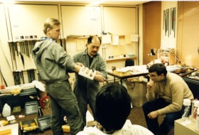
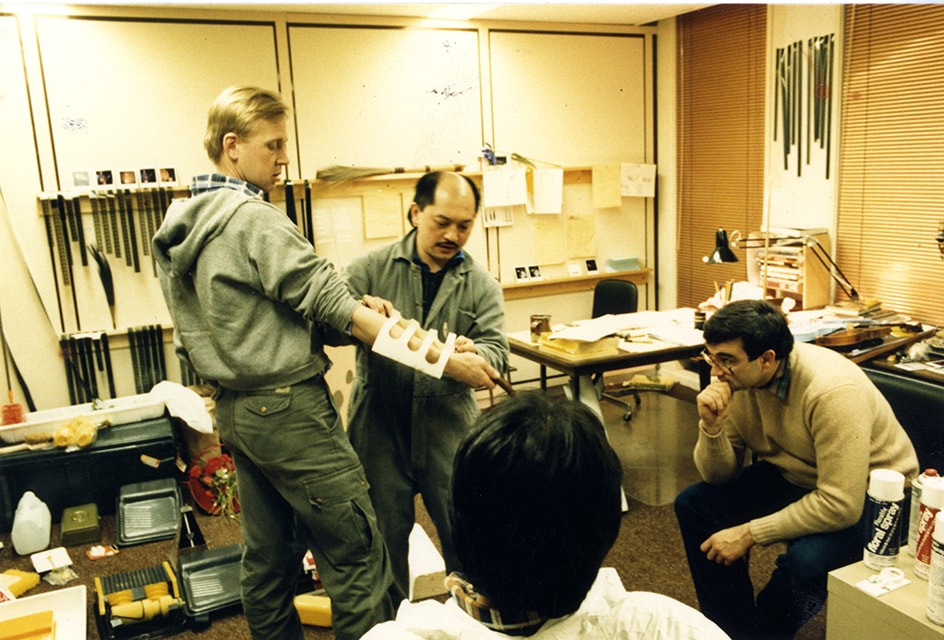
Jimmy Chow working on "Rainbow War"
https://search.heritageburnaby.ca/link/museumdescription19206
- Repository
- Burnaby Village Museum
- Date
- [1985]
- Collection/Fonds
- Hipman "Jimmy" Chow and Donna Polos fonds
- Description Level
- Item
- Physical Description
- 1 photograph : col. ; 15 x 10 cm
- Scope and Content
- Photograph of property master Jimmy Chow working with set decorator, Jim Ericson (left) and director, Bob Rogers (seated) on the short film "Rainbow War". The film was created for Expo 86.
- Repository
- Burnaby Village Museum
- Collection/Fonds
- Hipman "Jimmy" Chow and Donna Polos fonds
- Description Level
- Item
- Physical Description
- 1 photograph : col. ; 15 x 10 cm
- Scope and Content
- Photograph of property master Jimmy Chow working with set decorator, Jim Ericson (left) and director, Bob Rogers (seated) on the short film "Rainbow War". The film was created for Expo 86.
- Names
- Chow, Hipman "Jimmy"
- Accession Code
- BV022.21.50
- Access Restriction
- No restrictions
- Reproduction Restriction
- May be restricted by third party rights
- Date
- [1985]
- Media Type
- Photograph
- Scan Resolution
- 600
- Scan Date
- 2023-03-06
- Notes
- Title based on contents of photograph
- Hipman "Jimmy" Chow also used the name "James H. Chow" as a propety master in the film industry and was often credited by this name
Images
The naval air war in Korea
https://search.heritageburnaby.ca/link/museumlibrary3371
- Repository
- Burnaby Village Museum
- Author
- Hallion, Richard, 1948-
- Publication Date
- 1988
- c1986
- Call Number
- 951.9 HAL
- Repository
- Burnaby Village Museum
- Collection
- Special Collection
- Material Type
- Book
- Accession Code
- BV991.45.226
- ISBN
- 9780821722671
- Call Number
- 951.9 HAL
- Author
- Hallion, Richard, 1948-
- Place of Publication
- New York
- Publisher
- Kensington Pub. Corp.
- Publication Date
- 1988
- c1986
- Series
- Zebra book.
- Physical Description
- 383 p. : ill. ; 18 cm.
- Library Subject (LOC)
- Korean War, 1950-1953--Aerial operations, American
- United States. Navy--Aviation
- Names
- Oakalla Prison Farm
- Object History
- Salvaged from Oakalla Prison site in October 1991
The story of the Dominion : four hundred years in the annals of half a continent : a history of Canada from its early discovery and settlement to the present time : embrasing its growth, progress, and achievements in the pursuits of peace and war
https://search.heritageburnaby.ca/link/museumlibrary2900
- Repository
- Burnaby Village Museum
- Collection
- Special Collection
- Material Type
- Book
- Accession Code
- HV973.148.6
- Call Number
- 971 HOP
- Place of Publication
- Toronto
- Publisher
- John C. Winston
- Publication Date
- 1901
- Physical Description
- xv, 17-644 p. : ill., ports ; 25 cm.
- Inscription
- "San Jose" "pronounced" "San __[ha] _ei [Zei]" [handwritten in pencil on 5th page from front end paper] [h is crossed out in pencil]
- Library Subject (LOC)
- Canada--History
- Notes
- "Embellished with 64 full-page half-tone engravings, and portraits of more than 100 eminent men--the makers of Canada" -T.p.
Thrilling stories of the Russian-Japanese war : a vivid panorama of land and naval battles : a realistic description of twentieth century warfare ; the awful struggle for Japanese freedom, the peace and safety of the orient, and the protection of helpless China from the greed of foreign foes. Also a complete history of Japan, Russia, China, Korea and Manchuria, including progress, national traits and customs, religion, philosophy, personal adventure, etc.
https://search.heritageburnaby.ca/link/museumlibrary512
- Repository
- Burnaby Village Museum
- Collection
- Special Collection
- Material Type
- Book
- Accession Code
- BV986.53.19
- Call Number
- 952.031 MIL
- Place of Publication
- [S.l]
- Publisher
- [s.n.]
- Publication Date
- c1904
- Physical Description
- 463 p., [50] p. of plates : ill., maps, ports. ; 25 cm.
- Inscription
- "Presented to Violet Winters From Percy E. Haseltine" [handwritten in black ink on front endpaper]
- Library Subject (LOC)
- Russo-Japanese War, 1904-1905
- Russia--History--1904-1917
- Japan--History--20th century
- Notes
- "with an introduction by General Nelson A. Miles"--T.p.
- "The Japanese Point of View by Kogoro Takahira"--p.7
- "Graphically illustrated with nearly 100 superb engravings ; consisting of land and naval battles, views of war ships, portraits of Russian and Japanese commanders, pictures of famous cities, forts, temples and snap-shots of every-day life"--T.p.
- Author's given name and dates: Miller, J. Martin (James Martin), 1859-1939

Lochdale Neighbourhood
https://search.heritageburnaby.ca/link/landmark743
- Repository
- Burnaby Heritage Planning
- Associated Dates
- 1905-1924
- Heritage Value
- "Picturesquely situated on the south-westerly slope of the highest hill on the Burrard Peninsula is a district that in many ways resembles the early pioneer settlements…its centre is at the intersection of east Hastings Street and Sperling Avenue. Only a few years ago a dense forest covered this area and the settlers were few and some distance apart. After the war working men began to enter the Lochdale woods in quest of cheap home-sites. Today there are more than 400 residents in the district who combine to make a happy contented industrious community living on the edge of a big city yet enjoying the life offered by the country...The Community Hall is the centre of all social activities. Dances, concerts and other forms of entertainment are all there...Curtis Street runs from Sperling Avenue up to the hill, locally known as Hastings Grove. From the top on a clear day there is a view for miles around." ~ From the Sunday Province, March 8, 1925.
- Historic Neighbourhood
- Lochdale (Historic Neighbourhood)
- Planning Study Area
- Lochdale Area
Images


South Burnaby Cenotaph
https://search.heritageburnaby.ca/link/landmark860
- Repository
- Burnaby Heritage Planning
- Description
- The South Burnaby Cenotaph is located in Bonsor Park at the corner of Nelson Avenue and Imperial Street. The cenotaph commemorates those lost in the First World War, Second World War and the Korean War.
- Associated Dates
- 1988
- Other Names
- Bonsor Park Cenotaph
- Street View URL
- Google Maps Street View
- Repository
- Burnaby Heritage Planning
- Other Names
- Bonsor Park Cenotaph
- Geographic Access
- Nelson Avenue
- Associated Dates
- 1988
- Description
- The South Burnaby Cenotaph is located in Bonsor Park at the corner of Nelson Avenue and Imperial Street. The cenotaph commemorates those lost in the First World War, Second World War and the Korean War.
- Historic Neighbourhood
- Central Park (Historic Neighbourhood)
- Planning Study Area
- Marlborough Area
- Community
- Burnaby
- Cadastral Identifier
- P.I.D. No. 027-719-375
- Boundaries
- The property (Bonsor Park) is comprised of a single municipally-owned property located at 6749 Nelson Avenue.
- Area
- 3570.00
- Contributing Resource
- Landscape Feature
- Structure
- Ownership
- Public (local)
- Street Address
- 6749 Nelson Avenue
- Street View URL
- Google Maps Street View
Images


Duncan & Margaret McGregor Estate 'Glen-Lyon' Mansion
https://search.heritageburnaby.ca/link/landmark518
- Repository
- Burnaby Heritage Planning
- Description
- Overlooking the rich farmland of the Fraser River floodplain, 'Glen-Lyon' is an Edwardian era rural estate, with a tall, two and one-half storey plus basement wood-frame mansion, set in a pastoral and formal landscape with an associated barn and early log pond, located near a ravine and forested ar…
- Associated Dates
- 1902
- Formal Recognition
- Heritage Designation, Community Heritage Register
- Street View URL
- Google Maps Street View
- Repository
- Burnaby Heritage Planning
- Geographic Access
- Marine Drive
- Associated Dates
- 1902
- Formal Recognition
- Heritage Designation, Community Heritage Register
- Enactment Type
- Bylaw No. 12183
- Enactment Date
- 11/12/2006
- Description
- Overlooking the rich farmland of the Fraser River floodplain, 'Glen-Lyon' is an Edwardian era rural estate, with a tall, two and one-half storey plus basement wood-frame mansion, set in a pastoral and formal landscape with an associated barn and early log pond, located near a ravine and forested area adjacent to Marine Drive in South Burnaby.
- Heritage Value
- ‘Glen-Lyon’ is valued as an excellent example of a privately-owned Edwardian era country estate built at the turn of the nineteenth century. The property retains significant heritage features including the Edwardian era mansion with rustic Arts and Crafts features, and elements of a working agricultural landscape. The property was originally the Royal City Mills logging camp, and in 1900 was purchased by Duncan Campbell McGregor (1853-1929) and Margaret Jane McGregor (1875-1960), who named their estate ‘Glen-Lyon’ after Duncan McGregor’s birthplace in Perthshire, Scotland. The McGregors were active in municipal affairs and social activities, and played a significant role in the early development of Burnaby. Duncan McGregor served as a city councillor from 1909 to 1912 and was elected reeve of Burnaby in 1913. Margaret McGregor was instrumental in the formation and fundraising activities of the Victoria Order of Nurses in Burnaby. Additionally, the site is historically significant for its association with early social welfare and correctional reform. The estate was sold in 1926 to an inter-denominational religious organization called the Home of the Friendless, which used it as their B.C. headquarters. The organization was charged with several cases of abuse and neglect in 1937, after which a Royal Commission was formed that led to new legislation to regulate and license all private welfare institutions. 'Glen-Lyon' was sold to the provincial government, and was dedicated in 1939 by the Lt.-Gov. E.W. Hamber for use as the New Haven Borstal Home for Boys and Youthful Offenders (later renamed the New Haven Correction Centre). The Borstal movement originated in England in the late nineteenth century, as an alternative to sending young offenders and runaways to prisons by providing reformatories that focused on discipline and vocational skill. This site’s role as the first North American institution devoted to the Borstal School philosophy was historic, and influenced corrections programs across Canada. The site retains significant features from its development in 1939 as the Borstal School, including a large gambrel-roofed barn designed by Chief Provincial Architect Henry Whittaker of the Department of Public Works that is the only remaining structure of its kind in Burnaby. Between 1941 and 1945 the mansion housed the Provincial School for the Deaf and Blind when the Borstal School was closed temporarily as a war measure during the Second World War.
- Defining Elements
- Key elements that define the heritage character of 'Glen-Lyon' Mansion include its: - location on a sloping site with expansive southern exposure, adjacent to Marine Drive - residential form, scale and massing of the house as exemplified by its two and one-half storey height, above-ground basement and rectangular plan - Arts and Crafts elements of the house such as its stone foundation, multi-gabled roof line with steep central hipped roof, symmetrical cross-gables, side shed dormers, bellcast upper walls sheathed in cedar shingles and lower walls sheathed in narrow clapboard - original exterior features of the house such as the full width front verandah with square columns, central staircase on the southern elevation, original doors and stained glass windows; and the irregular fenestration such as double-hung 1-over-1 wooden-sash windows, bay windows, and projecting windows in the gable ends - original interior features of the house such as the U-shaped main stair designed around two symmetrically placed Ionic columns, and interior trim on the main floor including boxed beams and fireplaces - gambrel-roofed barn with roof vent with finial, sliding hay loft and access doors, small multi-pane windows, and lapped wooden siding - associated landscape features such as the original garden plantings with some exotic and many native specimen trees; the original log pond and its concrete Marine Drive causeway and culvert; rockeries and a rose garden
- Historic Neighbourhood
- Fraser Arm (Historic Neighbourhood)
- Planning Study Area
- Big Bend Area
- Architect
- Henry Whittaker
- Function
- Primary Historic--Estate
- Community
- Burnaby
- Cadastral Identifier
- 003-004-661
- Boundaries
- 'Glen-Lyon' is comprised of a single residential lot located at 4250 Marine Drive, Burnaby.
- Area
- 230873.18
- Contributing Resource
- Building
- Ownership
- Private
- Names
- McGregor, Duncan C. (1853-1929)
- Whittaker, Henry
- Home of the Friendless
- Borstal School
- New Haven Correction Centre
- Subjects
- Buildings - Heritage
- Buildings - Residential - Houses
- Buildings - Public - Detention Facilities
- Buildings - Residential
- Street Address
- 4250 Marine Drive
- Street View URL
- Google Maps Street View
Images


Cariboo-Armstrong Neighbourhood
https://search.heritageburnaby.ca/link/landmark825
- Repository
- Burnaby Heritage Planning
- Associated Dates
- 1955-2008
- Heritage Value
- The Cariboo-Armstrong Neighbourhood was mainly subdivided in the 1950s during the major building boom in Burnaby throughout the post-war years. Considered a primarily residential area, the neighbourhood has quick and convenient access to major highways and roads as well as being bordered to the north by the George Derby Conservation area.
- Historic Neighbourhood
- East Burnaby (Historic Neighbourhood)
- Planning Study Area
- Cariboo-Armstrong Area
Images


Joseph Clarke House
https://search.heritageburnaby.ca/link/landmark505
- Repository
- Burnaby Heritage Planning
- Description
- The Joseph Clarke House is a two and one-half storey, wood-frame house, with shingle siding, a front-gabled roof and a full open front verandah. It is located on Jersey Avenue within the Central Park neighbourhood of Burnaby.
- Associated Dates
- 1909
- Formal Recognition
- Heritage Designation, Community Heritage Register
- Other Names
- Joseph & Ellen Clarke House, Clarke Residence
- Street View URL
- Google Maps Street View
- Repository
- Burnaby Heritage Planning
- Other Names
- Joseph & Ellen Clarke House, Clarke Residence
- Geographic Access
- Jersey Avenue
- Sandell Street
- Associated Dates
- 1909
- Formal Recognition
- Heritage Designation, Community Heritage Register
- Enactment Type
- By-law No. 11930
- Enactment Date
- 29/08/2005
- Description
- The Joseph Clarke House is a two and one-half storey, wood-frame house, with shingle siding, a front-gabled roof and a full open front verandah. It is located on Jersey Avenue within the Central Park neighbourhood of Burnaby.
- Heritage Value
- Built circa 1909 for Central Park farmer Joseph Clarke (1851-1936) and his wife, Ellen (1864-1938), this Edwardian-era farm house is valued for its vernacular design, which demonstrates the utilitarian nature of working-class housing during the boom years prior to the First World War. The Joseph Clarke House is additionally valued for its link with the development of the Central Park neighbourhood during the Edwardian era. The advent of the Central Park interurban rail line in 1892, operated by the B.C. Electric Company, connected the area to Vancouver and led to its suburban development. This is one of the oldest surviving houses in the Central Park neighbourhood. It was designated as a municipal heritage site in 2005 and rehabilitated as part of the adjacent multi-family townhouse and apartment redevelopment.
- Defining Elements
- Key elements that define the heritage character of the Joseph Clarke House include its: - location on Jersey Avenue in the Central Park neighbourhood - residential form, scale and massing as expressed by its two and one-half storey height with rectangular plan, front bay window and front-gabled roof - wood-frame construction - Edwardian era detailing such as the open front verandah, asymmetrical front entrance, glazed front door with sidelights and triangular eave brackets
- Historic Neighbourhood
- Central Park (Historic Neighbourhood)
- Planning Study Area
- Garden Village Area
- Function
- Primary Historic--Single Dwelling
- Primary Current--Single Dwelling
- Community
- Burnaby
- Cadastral Identifier
- P.I.D. 027-101-428
- Boundaries
- The Joseph Clarke House is comprised of a single residential lot located at 5575 Jersey Avenue, Burnaby.
- Area
- 2370
- Contributing Resource
- Building
- Ownership
- Private
- Documentation
- City of Burnaby Planning and Building Department, Heritage Site Files
- Names
- Clarke, Joseph
- Clarke, Ellen
- Street Address
- 5575 Jersey Avenue
- Street View URL
- Google Maps Street View
Images


Lakeview-Mayfield Neighbourhood
https://search.heritageburnaby.ca/link/landmark830
- Repository
- Burnaby Heritage Planning
- Associated Dates
- 1955-2008
- Heritage Value
- Like many other areas of the City, the Lakeview-Mayfield Neighbourhood was subdivided during the 1950s post-war building boom. Pockets of newer homes were built in the 1970s, and the neighbourhood retained its character as a primarily residential area. The neighbourhood is bordered to the east by Robert Burnaby Park.
- Planning Study Area
- Lakeview-Mayfield Area
Images


Lochdale Neighbourhood
https://search.heritageburnaby.ca/link/landmark790
- Repository
- Burnaby Heritage Planning
- Associated Dates
- 1955-2008
- Heritage Value
- Despite the rapid growth witnessed in Burnaby in the post-war years, the Lochdale Neighbourhood was characterised as a close-knit primarily residential community. Although a commercial zone developed along Sperling and Hastings, single-family, duplex and multi-family homes were the primary buildings in the area. Basement suites and student accommodation also flourished in this neighbourhood after the creation of Simon Fraser University on Burnaby Mountain.
- Historic Neighbourhood
- Lochdale (Historic Neighbourhood)
- Planning Study Area
- Lochdale Area
Images


North Pacific Lumber Company Ruins
https://search.heritageburnaby.ca/link/landmark627
- Repository
- Burnaby Heritage Planning
- Geographic Access
- Barnet Road
- Associated Dates
- 1909
- Description
- Industrial building.
- Heritage Value
- Located on the shore of Burrard Inlet, these poured concrete piers of the smokestack burner and the former boiler and plant of the North Pacific Lumber Company are among the only remains of the once-thriving industrial site located on the waterfront on the south shore of Burrard Inlet. The sawmill and the Village of Barnet were initiated by David MacLaren, a wealthy lumberman from Buckingham, Quebec, who had previously established the Fraser Mills in Coquitlam in 1889. McLaren gambled that a sawmill on the main line of the C.P.R near Vancouver would serve the Canadian domestic market and be a profitable venture. The North Pacific Lumber Company established itself on this peninsula on Burrard Inlet and was fully operational in 1900. In 1909, the mill was completely burned out by a fire starting in the boiler room. Immediately the plant was rebuilt, modern in every respect and absolutely fireproof, as the entire power plant and boiler room was built of reinforced concrete and steel, of which these ruins are the last remains. The plant closed during the First World War and reopened as the Barnet Lumber Company in 1925 only to close forever in 1931 after a strike during the Great Depression.
- Locality
- Barnet
- Historic Neighbourhood
- Barnet (Historic Neighbourhood)
- Planning Study Area
- Burnaby Mountain Area
Images


St. John the Divine Anglican Church
https://search.heritageburnaby.ca/link/landmark514
- Repository
- Burnaby Heritage Planning
- Description
- St. John the Divine Anglican Church is a landmark wood-frame Gothic Revival church, with Gothic windows and spire. It is located on Kingsway, one of Burnaby’s main commercial thoroughfares, near the SkyTrain transit line and across the street from Central Park.
- Associated Dates
- 1905
- Formal Recognition
- Community Heritage Register
- Street View URL
- Google Maps Street View
- Repository
- Burnaby Heritage Planning
- Geographic Access
- Kingsway
- Associated Dates
- 1905
- Formal Recognition
- Community Heritage Register
- Enactment Type
- Council Resolution
- Enactment Date
- 09/06/2003
- Description
- St. John the Divine Anglican Church is a landmark wood-frame Gothic Revival church, with Gothic windows and spire. It is located on Kingsway, one of Burnaby’s main commercial thoroughfares, near the SkyTrain transit line and across the street from Central Park.
- Heritage Value
- St. John the Divine Anglican Church is valued as a symbol of the traditions of early Burnaby pioneers and as the oldest surviving church building in the city. Established in 1899, St. John was the first church in the community and was located at a prominent intersection of the old Vancouver-Westminster Road (now Kingsway) and the British Columbia Electric Railway’s interurban station at Central Park. This prominent intersection of the road and rail developed as the town centre of the Central Park district. The first St. John church was destroyed by fire, and was rebuilt at the same location in 1904-05. This church is additionally significant for its association with prominent local architect Joseph Henry Bowman (1864-1943) who emigrated from England in 1888. Bowman was a member of the parish, and designed both the first church and its subsequent replacement. Bowman’s prolific career embraced many stylistic changes and technological advances, and this church is a surviving example of one of his rare religious commissions. The design of the new church's nave and vestry was based on the Gothic Revival style of Christ Church Anglican in Surrey, B.C., which had been the former church of St. John’s incumbent Rev. William Bell. Evolving over time as the congregation grew, the church received a number of early additions, and in 1953 was substantially renovated and enlarged through a new design by Vancouver architect Ross Lort. The original church nave was separated from the tower and turned to allow for a large addition. The congregation relocated to a new church in 1998, and at that time removed the church's memorial windows, leaving behind a number of the original art glass windows installed in the 1920s. The church building was renovated in 2004-05, and surviving original elements were retained and restored, including of the original church tower and interior chancel ceiling. A valued feature of the building is the original cast iron church bell that remains in the tower. It was purchased by the children of the congregation in 1912, and in 1924 was rededicated on Armistice Day as a memorial to Burnaby resident Lt. James Donald McRae Reid, who died in the First World War.
- Defining Elements
- Key elements that define the heritage character of St. John the Divine Anglican Church include its: - location on the north side of Kingsway, opposite Central Park - ecclesiastical form, scale and massing as expressed by the offset tower and tall, gabled roof - tower with its original horizontal wooden drop siding, bellcast square roof with octagonal drum above and bellcast octagonal spire - cedar shingle roof cladding - metal cross at peak of spire - Gothic Revival details such as: Gothic lancet windows with leaded stained glass panels; Gothic entrance door at the base of the tower; pointed-arch louvers in the tower; and exterior gable end scissor-trusses - interior features such as wooden scissor-trusses with diagonal fir tongue and groove panelling on the ceiling above, fir tongue-and-groove panelling on the wall of the nave, and original cedar and fir pews and altar rails - cast iron bell in tower
- Historic Neighbourhood
- Central Park (Historic Neighbourhood)
- Planning Study Area
- Garden Village Area
- Architect
- Joesph Henry Bowman
- Function
- Primary Historic--Place of Worship
- Primary Current--Place of Worship
- Community
- Burnaby
- Cadastral Identifier
- 003-398-871
- Boundaries
- St. John the Divine Anglican Church is comprised of a single institutional lot located at 3891 Kingway, Burnaby.
- Area
- 3486.66
- Contributing Resource
- Building
- Ownership
- Private
- Street Address
- 3891 Kingsway
- Street View URL
- Google Maps Street View
Images


Stride Hill Neighbourhood
https://search.heritageburnaby.ca/link/landmark846
- Repository
- Burnaby Heritage Planning
- Associated Dates
- 1955-2008
- Heritage Value
- The residential areas that are located within the Stride Hill Neighbourhood were primarily developed in the 1950s during Burnaby's post-war building boom. The area lying to the south of Byrne Creek Ravine Park was used as a municipal garbage dump until the 1960s and as a landfill site for yard waste disposal until the early 1990s at which point the area was incorporated into the Edmonds Town Centre Plan and the land was made into park and open space.
- Historic Neighbourhood
- Edmonds (Historic Neighbourhood)
- Planning Study Area
- Stride Hill Area
Images


Sussex-Nelson Neighbourhood
https://search.heritageburnaby.ca/link/landmark838
- Repository
- Burnaby Heritage Planning
- Associated Dates
- 1955-2008
- Heritage Value
- The Sussex-Nelson Neighbourhood is located just south of Metrotown and in 1980 was characterised as the most populated of all of Burnaby's Planning Study areas. The area immediately south of Metrotown was initially developed as post-war 1950s housing stock, while the sector south of Rumble was developed after the 1960s and 1970s as single-family housing.
- Historic Neighbourhood
- Alta Vista (Historic Neighbourhood)
- Planning Study Area
- Sussex-Nelson Area
Images
