Narrow Results By
Decade
- 2020s 57
- 2010s 122
- 2000s 241
- 1990s 372
- 1980s 300
- 1970s 423
- 1960s 340
- 1950s 384
- 1940s 408
- 1930s 546
- 1920s 358
- 1910s
- 1900s 116
- 1890s 34
- 1880s 9
- 1870s 7
- 1860s 7
- 1850s 4
- 1840s 3
- 1830s 2
- 1820s 2
- 1810s 2
- 1800s 2
- 1790s 1
- 1780s 1
- 1770s 1
- 1760s 1
- 1750s 1
- 1740s 1
- 1730s 1
- 1720s 1
- 1710s 1
- 1700s 1
- 1690s 1
- 1680s 1
- 1670s 1
- 1660s 1
- 1650s 1
- 1640s 1
- 1630s 1
- 1620s 1
- 1610s 1
- 1600s 1

Indexed guide map of the city of Vancouver and Suburbs
https://search.heritageburnaby.ca/link/museumdescription8694
- Repository
- Burnaby Village Museum
- Date
- 1914
- Collection/Fonds
- Burnaby Village Museum Map collection
- Description Level
- Item
- Physical Description
- 1 map + textual record : col. lithographic print on paper ; 55 x 78 cm on sheet 58.5 x 82 cm folded to 20 x 10 cm
- Scope and Content
- Item consists of a map "Indexed Guide Map of the City of Vancouver and Suburbs compiled and published by The Vancouver Map and Blueprint Co. Ltd. Map shows district lots, blocks and boundaries between City of Vancouver, Point Grey, South Vancouver, Burnaby, New Westminster and parts of Richmond, No…
- Repository
- Burnaby Village Museum
- Collection/Fonds
- Burnaby Village Museum Map collection
- Description Level
- Item
- Physical Description
- 1 map + textual record : col. lithographic print on paper ; 55 x 78 cm on sheet 58.5 x 82 cm folded to 20 x 10 cm
- Material Details
- Scale not defined
- Map is folded into booklet form
- Scope and Content
- Item consists of a map "Indexed Guide Map of the City of Vancouver and Suburbs compiled and published by The Vancouver Map and Blueprint Co. Ltd. Map shows district lots, blocks and boundaries between City of Vancouver, Point Grey, South Vancouver, Burnaby, New Westminster and parts of Richmond, North Vancouver and West Vancouver. Concentric cirlces indicate the distance in miles from the intersection of Main Street and Hastings Street, Vancouver in intervals of 1/2 mile. Map is folded into booklet form and includes a four page index with cardstock cover. Index page 1 is titled "Hotels"; page 2 is titled "District Lot Index"; pages 3-8 "Street Index".
- Publisher
- Vancouver Map and Blueprint Company Limited
- Edition
- 5th Edition revised to June 1914
- Geographic Access
- Vancouver
- Accession Code
- HV983.9.18
- Date
- 1914
- Media Type
- Cartographic Material
- Scan Resolution
- 600
- Scan Date
- 2023-08-17
- Notes
- Transcribed title from map and cover
- Sticker adhered to front cover of index of two lions "Service / "WE GIVE IT" / WESTERN SPECIALTY / LIMITED/ STATIONERS AND PRINTERS / VANCOUVER - B.C."
Documents
Zoomable Images

![Bandsand in Stanley Park, Vancouver, BC, [between 1908 and 1911] thumbnail](/media/hpo/_Data/_BVM_Images/1972/1972_0050_0010_001.jpg?width=280)
Bandsand in Stanley Park, Vancouver, BC
https://search.heritageburnaby.ca/link/museumdescription1071
- Repository
- Burnaby Village Museum
- Date
- [between 1908 and 1911]
- Collection/Fonds
- Burnaby Village Museum Photograph collection
- Description Level
- Item
- Physical Description
- 1 photograph : sepia ; 7.3 x 9.9 cm
- Scope and Content
- Photograph of people walking towards the bandstand in Stanley Park, Vancouver. In 1934, the Malkin Bowl was erected at the site where the banstand used to be. An annotation on the back of the photograph reads, "Band stand in Stanley Park where Malkin Bowl now stands."
- Repository
- Burnaby Village Museum
- Collection/Fonds
- Burnaby Village Museum Photograph collection
- Description Level
- Item
- Physical Description
- 1 photograph : sepia ; 7.3 x 9.9 cm
- Scope and Content
- Photograph of people walking towards the bandstand in Stanley Park, Vancouver. In 1934, the Malkin Bowl was erected at the site where the banstand used to be. An annotation on the back of the photograph reads, "Band stand in Stanley Park where Malkin Bowl now stands."
- Geographic Access
- Vancouver
- Accession Code
- HV972.50.10
- Access Restriction
- No restrictions
- Reproduction Restriction
- No known restrictions
- Date
- [between 1908 and 1911]
- Media Type
- Photograph
- Scan Resolution
- 600
- Scan Date
- 2023-04-04
- Photographer
- Dean, H.M.
- Notes
- Title based on contents of photograph
Images
![Bandsand in Stanley Park, Vancouver, BC, [between 1908 and 1911] thumbnail](/media/hpo/_Data/_BVM_Images/1972/1972_0050_0010_001.jpg)
![Bird's eye view of New Westminster, Burnaby and Vancouver, [ca. 1911] thumbnail](/media/hpo/_Data/_BVM_Cartographic_Material/1983/1983_0012_0001_002%20Web.jpg?width=280)
Bird's eye view of New Westminster, Burnaby and Vancouver
https://search.heritageburnaby.ca/link/museumdescription8199
- Repository
- Burnaby Village Museum
- Date
- [ca. 1911]
- Collection/Fonds
- Burnaby Village Museum Map collection
- Description Level
- Item
- Physical Description
- 1 map : hand painted ; 65.5 x 99 cm
- Scope and Content
- An untitled monochromatic grayscale map of a developer's bird's eye view looking north west from Burnaby Mountain. View includes Burnaby, New Westminster, Vancouver with the North shore in the distance. Burnaby neighbourhood subdivisions of "Burnaby Heights" and "Buena Vista" are featured near the…
- Repository
- Burnaby Village Museum
- Collection/Fonds
- Burnaby Village Museum Map collection
- Description Level
- Item
- Physical Description
- 1 map : hand painted ; 65.5 x 99 cm
- Scope and Content
- An untitled monochromatic grayscale map of a developer's bird's eye view looking north west from Burnaby Mountain. View includes Burnaby, New Westminster, Vancouver with the North shore in the distance. Burnaby neighbourhood subdivisions of "Burnaby Heights" and "Buena Vista" are featured near the centre of the map. These neighbourhood subdivisions were marketed by Real Estate Agents Liebly & Blumer in 1911. Roads, buildings, factories, railways and bridges are identified on the map.
- Subjects
- Businesses - Real Estate Agencies
- Responsibility
- Leibly & Blumer Realty Co. Incorporated
- Accession Code
- HV983.12.1
- Access Restriction
- No restrictions
- Reproduction Restriction
- No known restrictions
- Date
- [ca. 1911]
- Media Type
- Cartographic Material
- Historic Neighbourhood
- East Burnaby (Historic Neighbourhood)
- Vancouver Heights (Historic Neighbourhood)
- Planning Study Area
- Cariboo-Armstrong Area
- Burnaby Heights Area
- Scan Resolution
- 300
- Scan Date
- December 2020
- Scale
- 100
- Notes
- Title based on contents of map
- Note in pencil on verso of photograph reads: "Make tint block of Buena Vista / Blocks only as shown in lots"
Zoomable Images
![Bird's eye view of New Westminster, Burnaby and Vancouver, [ca. 1911] thumbnail](/media/hpo/_Data/_BVM_Cartographic_Material/1983/1983_0012_0001_001_seadragon/1983_0012_0001_001.jpg?w=280)
The City of Vancouver B.C.
https://search.heritageburnaby.ca/link/archivedescription66103
- Repository
- City of Burnaby Archives
- Date
- [between 1916 and 1929]
- Collection/Fonds
- Burnaby Historical Society fonds
- Description Level
- Item
- Physical Description
- 1 map : b&w ink on paper ; 56 x 107 cm folded to 21 x 12.5 cm
- Scope and Content
- Item is a map of "[the] City of Vancouver B.C" drawn prior to amalgamation of Point Grey and South Vancouver with the City of Vancouver.
- Repository
- City of Burnaby Archives
- Date
- [between 1916 and 1929]
- Collection/Fonds
- Burnaby Historical Society fonds
- Subseries
- Ephemera subseries
- Physical Description
- 1 map : b&w ink on paper ; 56 x 107 cm folded to 21 x 12.5 cm
- Material Details
- Map has a blue construction paper cover
- Scale : 1 inch = 1000 feet
- Description Level
- Item
- Record No.
- 42707
- Accession Number
- BHS2007-04
- Scope and Content
- Item is a map of "[the] City of Vancouver B.C" drawn prior to amalgamation of Point Grey and South Vancouver with the City of Vancouver.
- Media Type
- Cartographic Material
- Notes
- Transcribed title
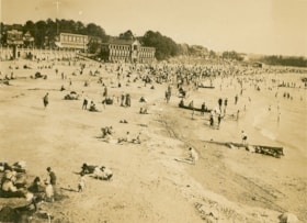
English Bay, Vancouver
https://search.heritageburnaby.ca/link/museumdescription1072
- Repository
- Burnaby Village Museum
- Date
- 1911
- Collection/Fonds
- Burnaby Village Museum Photograph collection
- Description Level
- Item
- Physical Description
- 1 photograph : b&w ; 7.3 x 9.9 cm
- Scope and Content
- Photograph of the beach at English Bay, Vancouver. The beach is crowded an buildings can be seen in the background.
- Repository
- Burnaby Village Museum
- Collection/Fonds
- Burnaby Village Museum Photograph collection
- Description Level
- Item
- Physical Description
- 1 photograph : b&w ; 7.3 x 9.9 cm
- Scope and Content
- Photograph of the beach at English Bay, Vancouver. The beach is crowded an buildings can be seen in the background.
- Geographic Access
- Vancouver
- Accession Code
- HV972.50.11
- Access Restriction
- No restrictions
- Reproduction Restriction
- No known restrictions
- Date
- 1911
- Media Type
- Photograph
- Scan Resolution
- 600
- Scan Date
- 2023-04-04
- Photographer
- Dean, H.M.
- Notes
- Title based on contents of photograph
- Annotation on verso of photograph reads: "English Bay/ 1911."
Images

General Relief Board - I.O.O.F. of Vancouver
https://search.heritageburnaby.ca/link/museumdescription9762
- Repository
- Burnaby Village Museum
- Date
- [ca. 1915]
- Collection/Fonds
- Hugh H. Stewart fonds
- Description Level
- Item
- Physical Description
- 1 textual record
- Scope and Content
- Item consists of a member card to certify Mr. H.H. Stewart as an accredited member of the General Relief Board, I.O.O.F. of Vancouver, B.C. The card is a visiting permit that allows the bearer to visit the Public or Semi-private Wards of the Vancouver General Hospital at any time. The card is signe…
- Repository
- Burnaby Village Museum
- Collection/Fonds
- Hugh H. Stewart fonds
- Description Level
- Item
- Physical Description
- 1 textual record
- Scope and Content
- Item consists of a member card to certify Mr. H.H. Stewart as an accredited member of the General Relief Board, I.O.O.F. of Vancouver, B.C. The card is a visiting permit that allows the bearer to visit the Public or Semi-private Wards of the Vancouver General Hospital at any time. The card is signed by the V.G.H. superintendent, Malcolm T. MacEachren.
- Names
- Stewart, Hugh Henry
- Accession Code
- HV979.50.271
- Access Restriction
- No restrictions
- Reproduction Restriction
- No known restrictions
- Date
- [ca. 1915]
- Media Type
- Textual Record
- Notes
- Title based on content of Item
![Granville Street, Vancouver, [1911] thumbnail](/media/hpo/_Data/_BVM_Images/1972/1972_0050_0006_001.jpg?width=280)
Granville Street, Vancouver
https://search.heritageburnaby.ca/link/museumdescription1067
- Repository
- Burnaby Village Museum
- Date
- [1911]
- Collection/Fonds
- Burnaby Village Museum Photograph collection
- Description Level
- Item
- Physical Description
- 1 photograph : b&w ; 8.0 x 10.2 cm
- Scope and Content
- Photograph of Granville Street, looking south. The two tall buildings to the sides are under construction. Busy street activities can be seen below with two trams running along the tracks. The old Vancouver Hotel is in view and the old courthouse (later the Vancouver Art Gallery) is in view faint…
- Repository
- Burnaby Village Museum
- Collection/Fonds
- Burnaby Village Museum Photograph collection
- Description Level
- Item
- Physical Description
- 1 photograph : b&w ; 8.0 x 10.2 cm
- Scope and Content
- Photograph of Granville Street, looking south. The two tall buildings to the sides are under construction. Busy street activities can be seen below with two trams running along the tracks. The old Vancouver Hotel is in view and the old courthouse (later the Vancouver Art Gallery) is in view faintly to the right of the photograph. An annoation on the back of the photograph reads, ""Granville St. - with OLD [underlined] / Vancouver Hotel across / from the Birks Building/ 1911/ (Court House in back of Van Hotel)."
- Geographic Access
- Vancouver
- Accession Code
- HV972.50.6
- Access Restriction
- No restrictions
- Reproduction Restriction
- No known restrictions
- Date
- [1911]
- Media Type
- Photograph
- Scan Resolution
- 600
- Scan Date
- 2023-04-04
- Photographer
- Dean, H.M.
- Notes
- Title based on contents of photograph
Images
![Granville Street, Vancouver, [1911] thumbnail](/media/hpo/_Data/_BVM_Images/1972/1972_0050_0006_001.jpg)
![Granville Street, Vancouver, [1910] thumbnail](/media/hpo/_Data/_BVM_Images/1972/1972_0050_0008_001.jpg?width=280)
Granville Street, Vancouver
https://search.heritageburnaby.ca/link/museumdescription1069
- Repository
- Burnaby Village Museum
- Date
- [1910]
- Collection/Fonds
- Burnaby Village Museum Photograph collection
- Description Level
- Item
- Physical Description
- 1 photograph : b&w ; 7.4 x 9.8 cm
- Scope and Content
- Photograph of Granville Street, looking north. Signs for "Fletchers Pianos" and the "Colonial Theatre" can be seen. The north shore is faintly visible across Burrard Inlet.
- Repository
- Burnaby Village Museum
- Collection/Fonds
- Burnaby Village Museum Photograph collection
- Description Level
- Item
- Physical Description
- 1 photograph : b&w ; 7.4 x 9.8 cm
- Scope and Content
- Photograph of Granville Street, looking north. Signs for "Fletchers Pianos" and the "Colonial Theatre" can be seen. The north shore is faintly visible across Burrard Inlet.
- Subjects
- Advertising Medium - Signs and Signboards
- Buildings - Commercial
- Geographic Features - Roads
- Geographic Access
- Vancouver
- Accession Code
- HV972.50.8
- Access Restriction
- No restrictions
- Reproduction Restriction
- No known restrictions
- Date
- [1910]
- Media Type
- Photograph
- Scan Resolution
- 600
- Scan Date
- 2023-04-04
- Photographer
- Dean, H.M.
- Notes
- Title based on contents of photograph
- An annotation on the back of the photograph reads, "Granville St. - 1910."
Images
![Granville Street, Vancouver, [1910] thumbnail](/media/hpo/_Data/_BVM_Images/1972/1972_0050_0008_001.jpg)
![Ladies Organization at the Vancouver Armouries, [between 1914 and 1918] thumbnail](/media/hpo/_Data/_Archives_Images/_Unrestricted/205/209-010.jpg?width=280)
Ladies Organization at the Vancouver Armouries
https://search.heritageburnaby.ca/link/archivedescription36011
- Repository
- City of Burnaby Archives
- Date
- [between 1914 and 1918]
- Collection/Fonds
- Burnaby Historical Society fonds
- Description Level
- Item
- Physical Description
- 1 photograph : b&w ; 8 x 10.5 cm print
- Scope and Content
- Photograph of a Ladies Organization at the Vancouver Armouries.
- Repository
- City of Burnaby Archives
- Date
- [between 1914 and 1918]
- Collection/Fonds
- Burnaby Historical Society fonds
- Subseries
- Gavin family subseries
- Physical Description
- 1 photograph : b&w ; 8 x 10.5 cm print
- Description Level
- Item
- Record No.
- 209-010
- Access Restriction
- No restrictions
- Reproduction Restriction
- No known restrictions
- Accession Number
- BHS1988-09
- Scope and Content
- Photograph of a Ladies Organization at the Vancouver Armouries.
- Media Type
- Photograph
- Notes
- Title based on contents of photograph
Images
![Ladies Organization at the Vancouver Armouries, [between 1914 and 1918] thumbnail](/media/hpo/_Data/_Archives_Images/_Unrestricted/205/209-010.jpg)
![Miss Scott's class at Vancouver Heights Public School, [after 1912] thumbnail](/media/hpo/_Data/_BVM_Images/1985/198900190001.jpg?width=280)
Miss Scott's class at Vancouver Heights Public School
https://search.heritageburnaby.ca/link/museumdescription72
- Repository
- Burnaby Village Museum
- Date
- [after 1912]
- Collection/Fonds
- Burnaby Village Museum Photograph collection
- Description Level
- Item
- Physical Description
- 1 photograph : sepia ; 10 x 15 cm mounted on card 18 x 23 cm
- Scope and Content
- Photograph of Miss Scott's class taken on the steps of Vancouver Heights Public School. The students are standing in seven rows and Miss Scott is standing on the left at the end of the second row.
- Repository
- Burnaby Village Museum
- Collection/Fonds
- Burnaby Village Museum Photograph collection
- Description Level
- Item
- Physical Description
- 1 photograph : sepia ; 10 x 15 cm mounted on card 18 x 23 cm
- Scope and Content
- Photograph of Miss Scott's class taken on the steps of Vancouver Heights Public School. The students are standing in seven rows and Miss Scott is standing on the left at the end of the second row.
- Subjects
- Occupations - Teachers
- Geographic Access
- Gilmore Avenue
- Street Address
- 50 Gilmore Avenue
- Accession Code
- BV989.19.1
- Access Restriction
- No restrictions
- Date
- [after 1912]
- Media Type
- Photograph
- Historic Neighbourhood
- Vancouver Heights (Historic Neighbourhood)
- Planning Study Area
- Burnaby Heights Area
- Scan Resolution
- 600
- Scan Date
- 01-Jun-09
- Scale
- 100
- Photographer
- McConnell, W. F.
- Notes
- Title based on contents of photograph
- Note written in pencil on verso of card mount reads: "R. G. McManus/ 4257 Dundas St [top two lines crossed out]/ North Burnaby B.C" and "c/o Terry Lynn Callender/ TEACHER MISS SCOTT"
- Note written in pen on verso of card mount reads: "AS OF FEB 28/85/ DAVID L. McMANUS/ [address follows]"
- Embossed letters on the card mount reads: "W. F. McConnell/ VANCOUVER, B.C."
Images
![Miss Scott's class at Vancouver Heights Public School, [after 1912] thumbnail](/media/hpo/_Data/_BVM_Images/1985/198900190001.jpg)
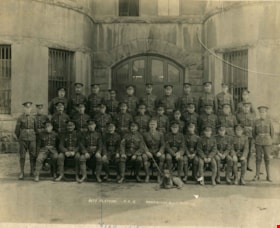
No. 1 Platoon R. S. G. Vancouver BC Sept. 1917
https://search.heritageburnaby.ca/link/archivedescription66226
- Repository
- City of Burnaby Archives
- Date
- 1917
- Collection/Fonds
- Peers Family and Hill Family fonds
- Description Level
- Item
- Physical Description
- 1 photograph : b&w ; 19.5 x 24.5 cm
- Scope and Content
- Photograph of the No. 1 Platoon, RSG, posed in full uniform outside the Vancouver armoury. Identified fifth from the left in the middle row is Claude Hill.
- Repository
- City of Burnaby Archives
- Date
- 1917
- Collection/Fonds
- Peers Family and Hill Family fonds
- Physical Description
- 1 photograph : b&w ; 19.5 x 24.5 cm
- Description Level
- Item
- Record No.
- 477-941
- Access Restriction
- No restrictions
- Reproduction Restriction
- No known restrictions
- Accession Number
- 2007-12
- Scope and Content
- Photograph of the No. 1 Platoon, RSG, posed in full uniform outside the Vancouver armoury. Identified fifth from the left in the middle row is Claude Hill.
- Subjects
- Clothing - Military Uniforms
- Buildings - Military
- Occupations - Military Personnel
- Wars - World War, 1914-1918
- Media Type
- Photograph
- Notes
- Title based on contents of photograph
- Note and arrow in blue pen on recto read: "LCH 1918"
Images

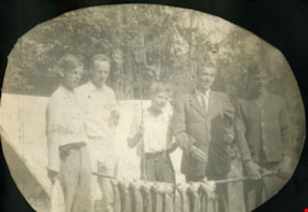
Parksville, Vancouver Island - The Crew and a 2 hour catch
https://search.heritageburnaby.ca/link/archivedescription66273
- Repository
- City of Burnaby Archives
- Date
- 1915
- Collection/Fonds
- Peers Family and Hill Family fonds
- Description Level
- Item
- Physical Description
- 1 photograph
- Scope and Content
- Photograph shows five people posed in front of a line of fish strung on a wooden pole. The label accompanying the photograph reads: "Parksville, Vancouver Island, July 1915, The Crew and a 2 hour catch." The man standing to the far left has been identified as Mr. Robert Travers, the young man sec…
- Repository
- City of Burnaby Archives
- Date
- 1915
- Collection/Fonds
- Peers Family and Hill Family fonds
- Physical Description
- 1 photograph
- Description Level
- Item
- Record No.
- 477-985
- Access Restriction
- No restrictions
- Reproduction Restriction
- No known restrictions
- Accession Number
- 2007-12
- Scope and Content
- Photograph shows five people posed in front of a line of fish strung on a wooden pole. The label accompanying the photograph reads: "Parksville, Vancouver Island, July 1915, The Crew and a 2 hour catch." The man standing to the far left has been identified as Mr. Robert Travers, the young man second from the right is Mike Peers, and to the far right is Bob Peers.
- Subjects
- Recreational Activities - Fishing
- Media Type
- Photograph
- Notes
- Title based on caption accompanying photograph
Images

Portion of New Westminster District with Adjacent Islands and Part of Vancouver Island
https://search.heritageburnaby.ca/link/museumdescription8690
- Repository
- Burnaby Village Museum
- Date
- 1910
- Collection/Fonds
- Burnaby Village Museum Map collection
- Description Level
- Item
- Physical Description
- 1 map : col. ink on canvas ; 68 x 90 cm on canvas 70 x 95 cm
- Scope and Content
- "Map of Portion of New Westminster District with Adjacent Islands and Part of Vancouver Island / Drawn at the Lands and Works Department. Victoria, B.C."
- Repository
- Burnaby Village Museum
- Collection/Fonds
- Burnaby Village Museum Map collection
- Description Level
- Item
- Physical Description
- 1 map : col. ink on canvas ; 68 x 90 cm on canvas 70 x 95 cm
- Material Details
- Scale 1/4 inch = 80 chains
- Scope and Content
- "Map of Portion of New Westminster District with Adjacent Islands and Part of Vancouver Island / Drawn at the Lands and Works Department. Victoria, B.C."
- Geographic Access
- Vancouver
- Accession Code
- BV994.11.9
- Access Restriction
- No restrictions
- Reproduction Restriction
- No known restrictions
- Date
- 1910
- Media Type
- Cartographic Material
- Notes
- Title based on contents of map
- Cleaned by conservator Dec 2009
![Post Office, Vancouver BC, [between 1908 and 1911] thumbnail](/media/hpo/_Data/_BVM_Images/1972/1972_0050_0004_001.jpg?width=280)
Post Office, Vancouver BC
https://search.heritageburnaby.ca/link/museumdescription1065
- Repository
- Burnaby Village Museum
- Date
- [between 1908 and 1911]
- Collection/Fonds
- Burnaby Village Museum Photograph collection
- Description Level
- Item
- Physical Description
- 1 photograph : sepia ; 8.8 x 10.2 cm, mounted on paper 13.5 x 12.2 cm
- Scope and Content
- Photograph of the post office near the downtown Vancouver waterfront. The north shore can be seen faintly across Burrard Inlet in the background. Inscribed on the negative, printed on the photograph, lower left: "Post Office / Vancouver B.C."
- Repository
- Burnaby Village Museum
- Collection/Fonds
- Burnaby Village Museum Photograph collection
- Description Level
- Item
- Physical Description
- 1 photograph : sepia ; 8.8 x 10.2 cm, mounted on paper 13.5 x 12.2 cm
- Material Details
- inscribed on the negative, printed on the photograph, l.l., "POST OFFICE/ VANCOUVER B.C."
- Scope and Content
- Photograph of the post office near the downtown Vancouver waterfront. The north shore can be seen faintly across Burrard Inlet in the background. Inscribed on the negative, printed on the photograph, lower left: "Post Office / Vancouver B.C."
- Subjects
- Buildings - Public - Post Offices
- Geographic Access
- Vancouver
- Accession Code
- HV972.50.4
- Access Restriction
- No restrictions
- Reproduction Restriction
- No known restrictions
- Date
- [between 1908 and 1911]
- Media Type
- Photograph
- Scan Resolution
- 600
- Scan Date
- 2023-03-28
- Photographer
- Dean, H.M.
Images
![Post Office, Vancouver BC, [between 1908 and 1911] thumbnail](/media/hpo/_Data/_BVM_Images/1972/1972_0050_0004_001.jpg)
![Students at Vancouver Heights Public School, [between 1912 and 1920] thumbnail](/media/hpo/_Data/_BVM_Images/1985/198900190002.jpg?width=280)
Students at Vancouver Heights Public School
https://search.heritageburnaby.ca/link/museumdescription73
- Repository
- Burnaby Village Museum
- Date
- [between 1912 and 1920]
- Collection/Fonds
- Burnaby Village Museum Photograph collection
- Description Level
- Item
- Physical Description
- 1 photograph : sepia ; 15 x 10.5 cm mounted on card 23 x 18 cm
- Scope and Content
- Photograph of students standing in six rows on the steps of Vancouver Heights Public School.
- Repository
- Burnaby Village Museum
- Collection/Fonds
- Burnaby Village Museum Photograph collection
- Description Level
- Item
- Physical Description
- 1 photograph : sepia ; 15 x 10.5 cm mounted on card 23 x 18 cm
- Scope and Content
- Photograph of students standing in six rows on the steps of Vancouver Heights Public School.
- Geographic Access
- Gilmore Avenue
- Street Address
- 50 Gilmore Avenue
- Accession Code
- BV989.19.2
- Access Restriction
- No restrictions
- Date
- [between 1912 and 1920]
- Media Type
- Photograph
- Historic Neighbourhood
- Vancouver Heights (Historic Neighbourhood)
- Planning Study Area
- Burnaby Heights Area
- Scan Resolution
- 600
- Scan Date
- 01-Jun-09
- Scale
- 100
- Notes
- Title based on contents of photograph
- Note written in pencil on verso of card mount reads: "c/o Terry Lynn Callender"
- Note written in pen on verso of card mount reads: "Jessie Horn -/ Mrs. R. G. McManus.", and "AS OF FEB 28/85/ DAVID L. McMANUS/ [address follows]"
Images
![Students at Vancouver Heights Public School, [between 1912 and 1920] thumbnail](/media/hpo/_Data/_BVM_Images/1985/198900190002.jpg)
Teachers at Vancouver Heights School
https://search.heritageburnaby.ca/link/archivedescription35428
- Repository
- City of Burnaby Archives
- Date
- 1912 (date of original), copied 1986
- Collection/Fonds
- Burnaby Historical Society fonds
- Description Level
- Item
- Physical Description
- 1 photograph : b&w ; 12.7 x 17.8 cm print
- Scope and Content
- Photograph of Dr. Carl Eaton (left), school principal, with unidentified teaching staff. Carl Eaton was the first principal of Vancouver Heights Public School, later called Gilmore Avenue School, when it opened in 1912.
- Repository
- City of Burnaby Archives
- Date
- 1912 (date of original), copied 1986
- Collection/Fonds
- Burnaby Historical Society fonds
- Subseries
- Pioneer Tales subseries
- Physical Description
- 1 photograph : b&w ; 12.7 x 17.8 cm print
- Description Level
- Item
- Record No.
- 204-286
- Access Restriction
- No restrictions
- Reproduction Restriction
- No known restrictions
- Accession Number
- BHS1988-03
- Scope and Content
- Photograph of Dr. Carl Eaton (left), school principal, with unidentified teaching staff. Carl Eaton was the first principal of Vancouver Heights Public School, later called Gilmore Avenue School, when it opened in 1912.
- Subjects
- Occupations - Teachers
- Media Type
- Photograph
- Notes
- Title based on contents of photograph
- Geographic Access
- Gilmore Avenue
- Street Address
- 50 Gilmore Avenue
- Historic Neighbourhood
- Vancouver Heights (Historic Neighbourhood)
- Planning Study Area
- Burnaby Heights Area
Images

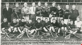
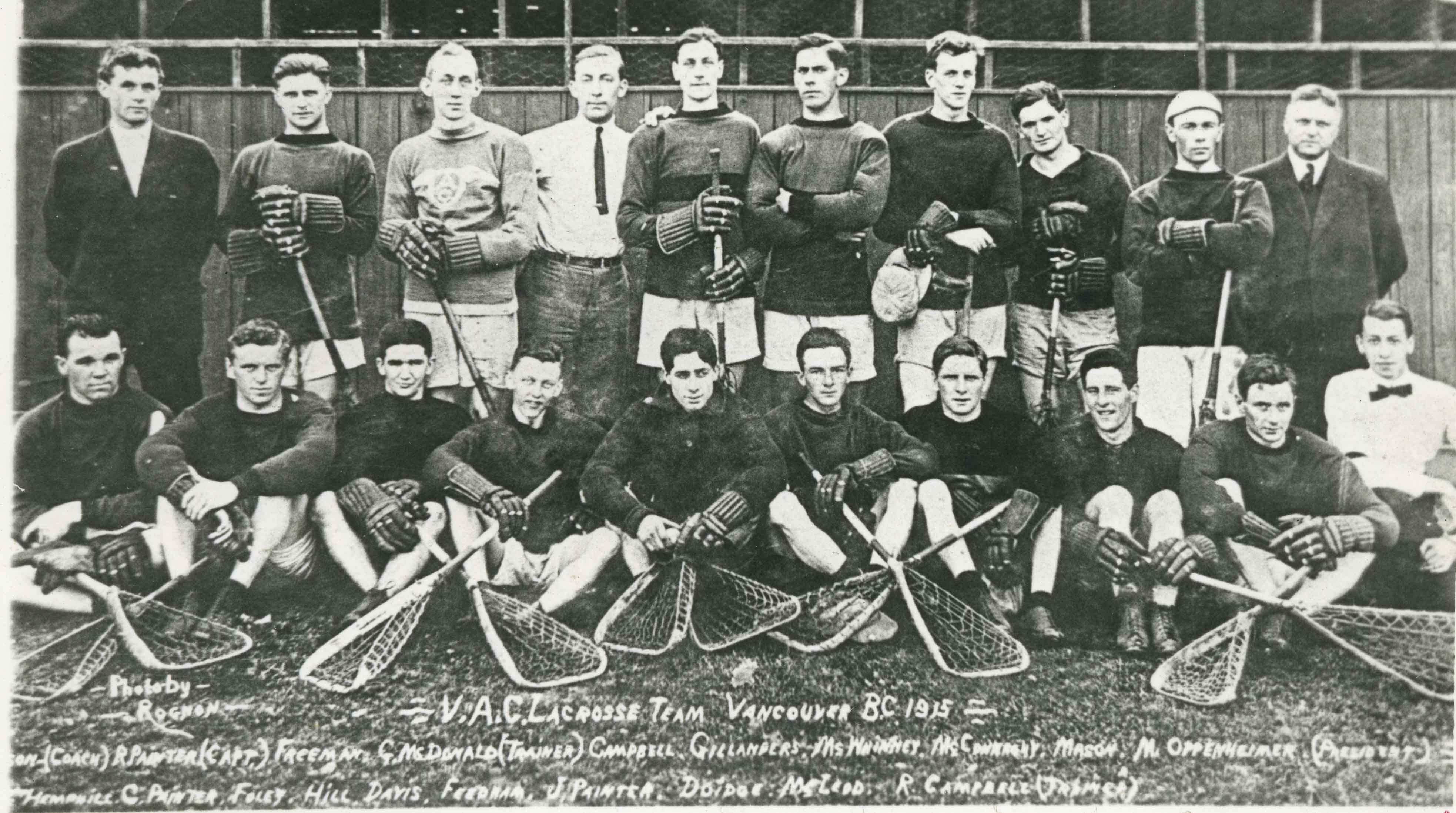
Vancouver Athletic Club Lacrosse Team
https://search.heritageburnaby.ca/link/archivedescription35743
- Repository
- City of Burnaby Archives
- Date
- 1915 (date of original), copied 1986
- Collection/Fonds
- Burnaby Historical Society fonds
- Description Level
- Item
- Physical Description
- 1 photograph : b&w ; 12.7 x 17.8 cm print
- Scope and Content
- Photograph of the Vancouver Athletic Club lacrosse team. Identified: (back row, left to right) Matheson (coach), R. Painter (captain), Freeman, McDonald (trainer), Campbell, Gillanders, McWhinney, McConnaghy, Mason, and Oppenheimer (president). (Front, left to right): Hemphill, C. Painter, Foley, …
- Repository
- City of Burnaby Archives
- Date
- 1915 (date of original), copied 1986
- Collection/Fonds
- Burnaby Historical Society fonds
- Subseries
- Pioneer Tales subseries
- Physical Description
- 1 photograph : b&w ; 12.7 x 17.8 cm print
- Description Level
- Item
- Record No.
- 204-601
- Access Restriction
- No restrictions
- Reproduction Restriction
- No known restrictions
- Accession Number
- BHS1988-03
- Scope and Content
- Photograph of the Vancouver Athletic Club lacrosse team. Identified: (back row, left to right) Matheson (coach), R. Painter (captain), Freeman, McDonald (trainer), Campbell, Gillanders, McWhinney, McConnaghy, Mason, and Oppenheimer (president). (Front, left to right): Hemphill, C. Painter, Foley, Hill, Davis, Burnie Feedham, J. Painter, Doidge, McLeod, and Campbell (trainer).
- Media Type
- Photograph
- Notes
- Title based on contents of photograph
- Annotation on bottom of photograph reads, "V.A.C. Lacrosse Team Vancouver B.C. 1915" and the names of the players, the photographer is also identified as [Rognon or Roghon]
Images

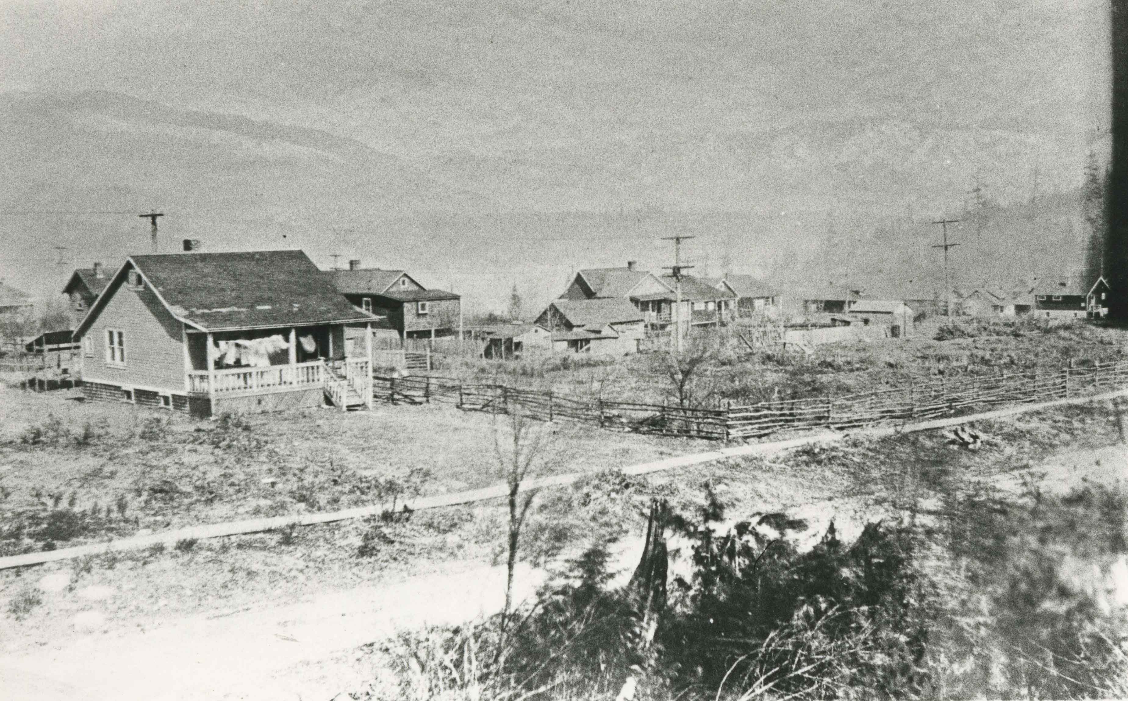
Vancouver Heights
https://search.heritageburnaby.ca/link/archivedescription35426
- Repository
- City of Burnaby Archives
- Date
- 1913 (date of original), copied 1986
- Collection/Fonds
- Burnaby Historical Society fonds
- Description Level
- Item
- Physical Description
- 1 photograph : b&w ; 12.7 x 17.8 cm print
- Scope and Content
- Photograph of a general view of Vancouver Heights. The car is on Ingleton Avenue near the corner of Triumph Street, looking east to MacDonald Avenue and Gilmore Avenue. Vancouver Heights Presbyterian Church and Gilmore Avenue School can be seen in the background at the right. The photograph is by D…
- Repository
- City of Burnaby Archives
- Date
- 1913 (date of original), copied 1986
- Collection/Fonds
- Burnaby Historical Society fonds
- Subseries
- Pioneer Tales subseries
- Physical Description
- 1 photograph : b&w ; 12.7 x 17.8 cm print
- Description Level
- Item
- Record No.
- 204-284
- Access Restriction
- No restrictions
- Reproduction Restriction
- No restrictions
- Accession Number
- BHS1988-03
- Scope and Content
- Photograph of a general view of Vancouver Heights. The car is on Ingleton Avenue near the corner of Triumph Street, looking east to MacDonald Avenue and Gilmore Avenue. Vancouver Heights Presbyterian Church and Gilmore Avenue School can be seen in the background at the right. The photograph is by Dr. Carl Eaton, teacher, principal and later family physician.
- Media Type
- Photograph
- Photographer
- Eaton, Dr. Carl
- Notes
- Title based on contents of photograph
- Geographic Access
- Ingleton Avenue
- MacDonald Avenue
- Triumph Street
- Historic Neighbourhood
- Vancouver Heights (Historic Neighbourhood)
- Planning Study Area
- Willingdon Heights Area
Images


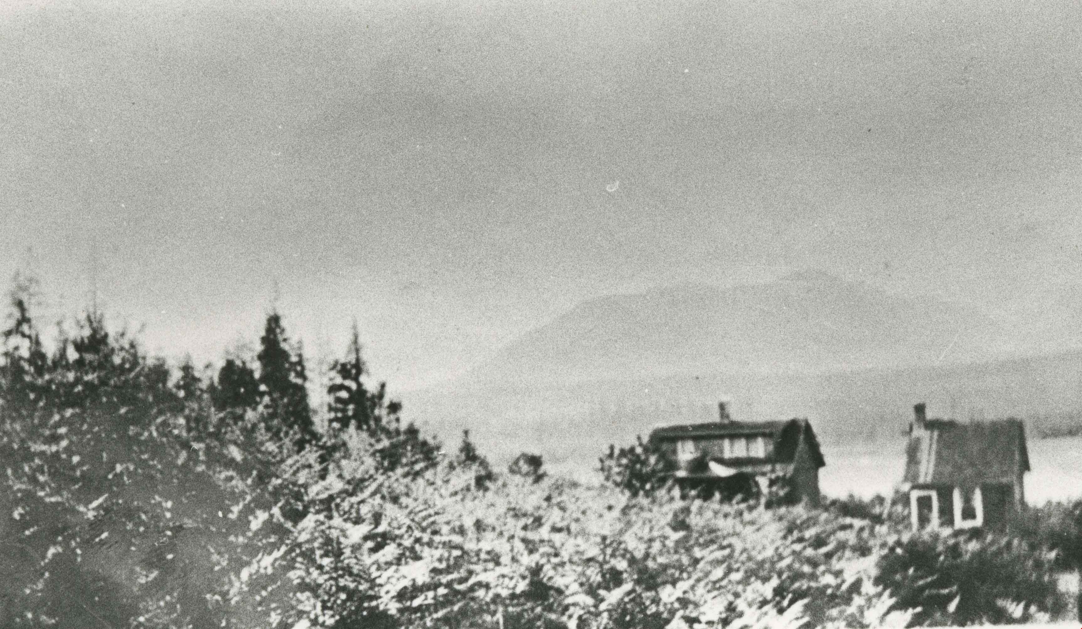
Vancouver Heights area
https://search.heritageburnaby.ca/link/archivedescription35266
- Repository
- City of Burnaby Archives
- Date
- 1911 (date of original), copied 1986
- Collection/Fonds
- Burnaby Historical Society fonds
- Description Level
- Item
- Physical Description
- 1 photograph : b&w ; 12.7 x 17.8 cm print
- Scope and Content
- Photograph of Carleton Avenue and Yale Street area in the neighbourhood where David Taylor and Henry Ward built their duplex for their families in 1911, when they emigrated from England. Both families had two children: Douglas and Hilda Ward, and Marjorie and Winnie Taylor.
- Repository
- City of Burnaby Archives
- Date
- 1911 (date of original), copied 1986
- Collection/Fonds
- Burnaby Historical Society fonds
- Subseries
- Pioneer Tales subseries
- Physical Description
- 1 photograph : b&w ; 12.7 x 17.8 cm print
- Description Level
- Item
- Record No.
- 204-123
- Access Restriction
- No restrictions
- Reproduction Restriction
- No known restrictions
- Accession Number
- BHS1988-03
- Scope and Content
- Photograph of Carleton Avenue and Yale Street area in the neighbourhood where David Taylor and Henry Ward built their duplex for their families in 1911, when they emigrated from England. Both families had two children: Douglas and Hilda Ward, and Marjorie and Winnie Taylor.
- Subjects
- Geographic Features - Neighbourhoods
- Media Type
- Photograph
- Notes
- Title based on contents of photograph
- Geographic Access
- Carleton Avenue
- Yale Street
- Historic Neighbourhood
- Vancouver Heights (Historic Neighbourhood)
- Planning Study Area
- Burnaby Heights Area
Images

Vancouver Heights area
https://search.heritageburnaby.ca/link/archivedescription35267
- Repository
- City of Burnaby Archives
- Date
- 1911 (date of original), copied 1986
- Collection/Fonds
- Burnaby Historical Society fonds
- Description Level
- Item
- Physical Description
- 1 photograph : b&w ; 12.7 x 17.8 cm print
- Scope and Content
- Photograph taken from the corner of Carleton Avenue and McGill Street, looking northeast. This later became the site of McGill Park.
- Repository
- City of Burnaby Archives
- Date
- 1911 (date of original), copied 1986
- Collection/Fonds
- Burnaby Historical Society fonds
- Subseries
- Pioneer Tales subseries
- Physical Description
- 1 photograph : b&w ; 12.7 x 17.8 cm print
- Description Level
- Item
- Record No.
- 204-124
- Access Restriction
- No restrictions
- Reproduction Restriction
- No known restrictions
- Accession Number
- BHS1988-03
- Scope and Content
- Photograph taken from the corner of Carleton Avenue and McGill Street, looking northeast. This later became the site of McGill Park.
- Subjects
- Geographic Features - Neighbourhoods
- Media Type
- Photograph
- Photographer
- Sutcliffe, Arthur
- Notes
- Title based on contents of photograph
- Geographic Access
- Carleton Avenue North
- McGill Park
- McGill Street
- Historic Neighbourhood
- Vancouver Heights (Historic Neighbourhood)
- Planning Study Area
- Burnaby Heights Area
Images