Narrow Results By
Subject
- Agriculture - Farms 1
- Animals - Dogs 2
- Animals - Poultry 1
- Buildings - Civic - Fire Halls 1
- Buildings - Commercial - Hardware Stores 1
- Buildings - Commercial - Stores 1
- Buildings - Heritage 1
- Buildings - Industrial - Mills 1
- Buildings - Religious - Churches 5
- Buildings - Residential - Houses 13
- Buildings - Schools 9
- Ceremonies - Graduations 1
Creator
- Bingham, Alfred "Alf" 2
- Blake, Frederick "Fred" 1
- Bowman and Cullerne 1
- Bowman & Cullerne 1
- British Columbia Underwriters' Association 6
- Burnett & McGugan, Engineers and Surveyors 1
- Charlton and Rathburn 1
- Eaton, Dr. Carl 1
- Henton, John Morse 1
- McConnell, W. F. 1
- Plan Department, British Columbia Insurance Underwriters' Association 5
![Aili Rintanen (later Topalian) holding cat, next to her sister who has a rooster in her arms, [1937]. Item no. 337-003. thumbnail](/media/hpo/_Data/_Archives_Images/_Unrestricted/316/337-003.jpg?width=280)
Interview with Aili Topalian by Eric Damer October 11, 2012 - Track 2
https://search.heritageburnaby.ca/link/oralhistory420
- Repository
- City of Burnaby Archives
- Date Range
- 1920-1945
- Length
- 0:07:49
- Summary
- This portion of the recording pertains to Aili (Rintanen) Topalian's collection of photographs. Aili describes each photograph and tells stories of her childhood along the waterfront at Burrard Inlet; the homes of Crabtown were built on decks which were on top of pilings, that were sunk deep into t…
- Repository
- City of Burnaby Archives
- Summary
- This portion of the recording pertains to Aili (Rintanen) Topalian's collection of photographs. Aili describes each photograph and tells stories of her childhood along the waterfront at Burrard Inlet; the homes of Crabtown were built on decks which were on top of pilings, that were sunk deep into the sand.
- Date Range
- 1920-1945
- Photo Info
- Aili Rintanen (later Topalian) holding cat, next to her sister who has a rooster in her arms, [1937]. Item no. 337-003.
- Length
- 0:07:49
- Geographic Access
- Burrard Inlet
- Historic Neighbourhood
- Vancouver Heights (Historic Neighbourhood)
- Interviewer
- Damer, Eric
- Interview Date
- October 11, 2012
- Scope and Content
- Recording is an interview with Aili (Rintanen) Topalian conducted by Burnaby Village Museum employee Eric Damer, October 11, 2012. Major theme discussed: growing up in Crabtown.
- Biographical Notes
- Aili Rintanen (later Topalian) came to British Columbia in 1936 from a homestead near Burnt Lake, Alberta. After a few months in Vancouver and then a Burnaby apartment, the Rintanens moved to a house on the Burrard Inlet. The family lived over the water, in a house built on a deck, secured to the top of pilings that were sunk deep into the sand. Aili's mother Aune Rintanen found work at a fish and chip shop in downtown Vancouver and her father Gus Rintanen worked in a nearby mill. Aili and her sister Trudi (later Tuomi), attended school in Burnaby. For nine years the Rintanens created a home for themselves in an area now called Crabtown, although no one living there called it that.
- Total Tracks
- 4
- Total Length
- 0:39:00
- Interviewee Name
- Topalian, Aili Rintanen
- Interview Location
- Interviewee's residence
- Interviewer Bio
- Eric Damer is a lifelong British Columbian born in Victoria, raised in Kamloops, and currently residing in Burnaby. After studying philosophy at the University of Victoria, he became interested in the educational forces that had shaped his own life. He completed master’s and doctoral degrees in educational studies at the University of British Columbia with a particular interest in the history of adult and higher education in the province. In 2012, Eric worked for the City of Burnaby as a field researcher and writer, conducting interviews for the City Archives and Museum Oral History Program.
- Collection/Fonds
- Community Heritage Commission Special Projects fonds
- Transcript Available
- None
- Media Type
- Sound Recording
Images
![Aili Rintanen (later Topalian) holding cat, next to her sister who has a rooster in her arms, [1937]. Item no. 337-003. thumbnail](/media/hpo/_Data/_Archives_Images/_Unrestricted/316/337-003.jpg)
Audio Tracks
Track two of recording of interview with Aili Topalian
Track two of recording of interview with Aili Topalian
https://search.heritageburnaby.ca/media/hpo/_Data/_Archives_Oral_Histories/_Unrestricted/MSS171-028/MSS171-028_Track_2.mp3Interview with Annie Boulanger by Rod Fowler April 9, 1990 - Track 6
https://search.heritageburnaby.ca/link/oralhistory488
- Repository
- City of Burnaby Archives
- Date Range
- 1925-1970
- Length
- 00:07:42
- Summary
- This portion of the interview is about Annie Boulanger’s family history, her parents’ origin, work and move to Burnaby, what the Napier Street area looked like in the 1950s and the Government Street neighbourhood in the 1960s, her education and teaching career, and her marriage. She explains why Go…
- Repository
- City of Burnaby Archives
- Summary
- This portion of the interview is about Annie Boulanger’s family history, her parents’ origin, work and move to Burnaby, what the Napier Street area looked like in the 1950s and the Government Street neighbourhood in the 1960s, her education and teaching career, and her marriage. She explains why Government Street has a jog in it at Brighton.
- Date Range
- 1925-1970
- Length
- 00:07:42
- Subjects
- Occupations - Teachers
- Historic Neighbourhood
- Vancouver Heights (Historic Neighbourhood)
- Lozells (Historic Neighbourhood)
- Planning Study Area
- Burnaby Heights Area
- Government Road Area
- Interviewer
- Fowler, Rod
- Interview Date
- April 9, 1990
- Scope and Content
- Recording is of an interview with Annie Boulanger, conducted by Rod Fowler. Annie Boulanger was one of eleven participants interviewed as part of the SFU/Burnaby Centennial Committee's oral history series titled, "Voices of Burnaby". The interview is mainly about Annie Boulanger’s volunteer community work in Burnaby, including initiating the teaching of french and gymnastics at Seaforth School where her children attended, doing historical research and oral histories for Burnaby Heritage Village and the SFU Archives, becoming a long term member of the Burnaby Writers’ Club, being a member and President of Burnaby Arts Council, and member of the Parks Board's Centre for the Performing Arts Committee (1987). The interview focuses attention on the Arts Council’s financial difficulties between 1985 and 1990, and the need for a comprehensive approach to supporting the arts through a municipal arts policy. Annie Boulanger also talks about her parents’ history, their home on Napier Street and her later home on Government Road, her education and teaching career, and her arts journalism. To view “Narrow By” terms for each track expand this description and see “Notes”.
- Biographical Notes
- Annie Urbanovits Boulanger’s parents emigrated from Hungary to Toronto, Louis in 1925 and Irene in 1930, where they married. Louis and Irene Boulanger moved to Vancouver where Louis worked in the Vancouver Shipyards during WWII and then for Nichols Chemical Company in Barnet for 15 years. While the Urbanovits family lived in Cloverdale, Louis commuted to Kask’s Camp in Barnet, until they moved to Burnaby in 1951 to an old farm purchased on Napier Street. Between 1951 and 1956 Annie completed her BA degree, majoring in chemistry and english with a minor in physical education, and obtained her teaching diploma at UBC. She taught for 4 years in various locations in BC before marrying and moving to Manitoba and Ottawa. She and her husband and five children (two more children to come later) returned to Burnaby in 1964 to a home on Government Street to be close to family. Annie Boulanger became involved in the community first through her children’s school, initiating and teaching french classes in Seaforth School in 1969, and supporting the development of gymnastics in school and as a municipal program. Her interest in Archives lead to doing oral histories for John Adams, curator of Heritage Village [Burnaby Heritage Village], and for SFU Archives. She became a long time member of the Burnaby Writers’ Club in the 1970s, taking a course in writing non-fiction from Chris Potter. In 1983 Annie Boulanger joined the Burnaby Arts Council, becoming President in 1985. She was involved in lobbying the municipality for better monetary support and facilities for the arts and for the creation of a Municipal Arts Policy. She has continued to promote the arts in Burnaby through her appointment to Burnaby’s Visual Arts Advisory Board in 1997, her arts journalism, writing regular book and theatre reviews for the local newspaper, and other activities. She was a member of the Burnaby Centennial Committee and was one of the editors of the book “Burnaby Centennial Anthology”.
- Total Tracks
- 8
- Total Length
- 0:41:53
- Interviewee Name
- Boulanger, Annie
- Interviewer Bio
- Rod Fowler returned to university as a mature student in the 1980s after working about twenty years in the field of economics and computerization in business in England, Europe and Western Canada. He graduated with a BA from SFU in both History and Sociology in 1987, his MA degree in Geography in 1989, and his PhD in Cultural Geography at SFU. He taught courses in Geography, Sociology, History and Canadian Studies at several Lower Mainland colleges, before becoming a full time member of the Geography Department at Kwantlen University College.
- Collection/Fonds
- SFU/Burnaby Centennial Committee fonds
- Transcript Available
- Transcript available
- Media Type
- Sound Recording
- Web Notes
- Interviews were digitized in 2015 allowing them to be accessible on Heritage Burnaby. The digitization project was initiated by the Community Heritage Commission with support from City of Burnaby Council.
Audio Tracks
Track six of interview with Annie Boulanger
Track six of interview with Annie Boulanger
https://search.heritageburnaby.ca/media/hpo/_Data/_Archives_Oral_Histories/_Unrestricted/MSS187-022/MSS187-022_Track_6.mp3Interview with Edward Apps by Rod Fowler February 22, 1990 - Track 2
https://search.heritageburnaby.ca/link/oralhistory456
- Repository
- City of Burnaby Archives
- Date Range
- 1918-1950
- Length
- 00:05:30
- Summary
- This portion of the interview is about Ed Apps’ brief overview of the changes in Burnaby since he arrived in 1946, where he grew up in England, his war service, and the reasons that he and his wife Margaret immigrated to Canada from England
- Repository
- City of Burnaby Archives
- Summary
- This portion of the interview is about Ed Apps’ brief overview of the changes in Burnaby since he arrived in 1946, where he grew up in England, his war service, and the reasons that he and his wife Margaret immigrated to Canada from England
- Date Range
- 1918-1950
- Length
- 00:05:30
- Subjects
- Migration
- Historic Neighbourhood
- Vancouver Heights (Historic Neighbourhood)
- Planning Study Area
- Burnaby Heights Area
- Interviewer
- Fowler, Rod
- Interview Date
- February 22, 1990
- Scope and Content
- Recording is of an interview with Edward Apps, conducted by Rod Fowler. Ed Apps was one of eleven participants interviewed as part of the SFU/Burnaby Centennial Committee's oral history series titled, "Voices of Burnaby". The interview is mainly about Ed Apps involvement in community groups, particularly his work in seniors organizations lobbying for seniors’ housing since his retirement, and views about the role of Rate Payer groups, unions and politics in the development of North and South Burnaby. He also talks about his origin in England, his war service, arrival with his wife Margaret in Burnaby in 1946, his work with the Burnaby School Board and for the local union, the location of some of the older schools, the history of his house, and briefly about his wife and children. To view “Narrow By” terms for each track expand this description and see “Notes”.
- Biographical Notes
- Edward Apps was born in 1918 in London, England, and grew up in Kent and Essex. In WWII he flew the third glider to land in Normandy on June 6th, 1944. He and his wife Margaret Hope (1915-1985) immigrated to British Columbia in 1946, joining his wife’s parents, who had immigrated earlier in 1939, in Burnaby Heights in North Burnaby. He worked for the Burnaby School Board as Foreman Painter, and served on CUPE Local 379 Executive, until his retirement in 1982. In 1948 Ed Apps bought his first lot, for $150.00, in the 4700 block on Georgia Street, building houses there and in the 4100 block before buying his present home, a ca.1900 farm building, in the same area in 1954. North Burnaby was “bush country and orchards” in the 1950s; his two sons played in the ravines; and the family used the tram system on Hastings and Boundary Road for transportation. Development of municipal services seemed slower in North than South Burnaby, and Ed Apps remembers the strong role Rate Payers groups had in creating local services and lobbying Municipal Council for provide services. After retirement Ed Apps became involved in several local and provincial seniors organizations, advocating for better housing, including serving on the Executives of the Network of Burnaby Seniors and the Council of Senior Citizens Organization, and was active in the provincial Seniors Research and Resource and CMHC Housing Committee. He also served on the Centennial Committee of Burnaby.
- Total Tracks
- 8
- Total Length
- 0:56:50
- Interviewee Name
- Apps, Ed
- Interviewer Bio
- Rod Fowler returned to university as a mature student in the 1980s after working about twenty years in the field of economics and computerization in business in England, Europe and Western Canada. He graduated with a BA from SFU in both History and Sociology in 1987, his MA degree in Geography in 1989, and his PhD in Cultural Geography at SFU. He taught courses in Geography, Sociology, History and Canadian Studies at several Lower Mainland colleges, before becoming a full time member of the Geography Department at Kwantlen University College.
- Collection/Fonds
- SFU/Burnaby Centennial Committee fonds
- Transcript Available
- Transcript available
- Media Type
- Sound Recording
- Web Notes
- Interviews were digitized in 2015 allowing them to be accessible on Heritage Burnaby. The digitization project was initiated by the Community Heritage Commission with support from City of Burnaby Council.
Audio Tracks
Track two of interview with Ed Apps
Track two of interview with Ed Apps
https://search.heritageburnaby.ca/media/hpo/_Data/_Archives_Oral_Histories/_Unrestricted/MSS187-015/MSS187-015_Track_2.mp3![Elsie Brown-John (bottom, far right) with her class at Kitchener Street School, [1936]. Item no. 549-001. thumbnail](/media/hpo/_Data/_Archives_Images/_Unrestricted/540/549-001.jpg?width=280)
Interview with Elsie Ansdell by Eric Damer September 18, 2012 - Track 1
https://search.heritageburnaby.ca/link/oralhistory287
- Repository
- City of Burnaby Archives
- Date Range
- 1910-1946
- Length
- 0:09:17
- Summary
- This portion of the recording pertains to the Brown-Johns first settling in Burnaby. Elsie (Brown-John) Ansdell discusses land clearing for the family home, each of her parents and her brothers.
- Repository
- City of Burnaby Archives
- Summary
- This portion of the recording pertains to the Brown-Johns first settling in Burnaby. Elsie (Brown-John) Ansdell discusses land clearing for the family home, each of her parents and her brothers.
- Date Range
- 1910-1946
- Photo Info
- Elsie Brown-John (bottom, far right) with her class at Kitchener Street School, [1936]. Item no. 549-001.
- Length
- 0:09:17
- Subjects
- Land Clearing
- Geographic Access
- Napier Street
- Historic Neighbourhood
- Vancouver Heights (Historic Neighbourhood)
- Planning Study Area
- Willingdon Heights Area
- Interviewer
- Damer, Eric
- Interview Date
- September 18, 2012
- Scope and Content
- Recording is an interview with early Burnaby resident Elsie (Brown-John) Ansdell conducted by Burnaby Village Museum employee Eric Damer, September 18, 2012. Major themes discussed are: settling in Burnaby and the early years of the Brown-John family.
- Biographical Notes
- Elsie (Brown-John) Ansdell’s father, a trained carpenter and cabinet maker, Victor Brown-John came to Canada from Wales in 1910. He cleared three lots at Napier and Gilmore Streets and built a two-roomed house. In 1912, he was joined by his wife and two eldest sons, Victor and Archie. Twin boys, Frank and Roy, were born in 1914 in the Burnaby home and their fifth son, Clive, was born in 1915. From 1916 to 1919 Victor John-Brown left Burnaby to serve overseas. Elsie Brown-John (later Ansdell) was born in 1921. Her younger brother, Gwyn "Jerry" was born in 1923. In 1925 Victor Brown-John suffered a fatal accident while working as a longshoreman in Northern British Columbia. Elsie attended Kitchener Elementary and North Burnaby High School. She married during the Second World War and moved to South Burnaby to raise her family whilst continuing to work in various department stores both in Vancouver and Burnaby.
- Total Tracks
- 4
- Total Length
- 33:02
- Interviewee Name
- Ansdell, Elsie Brown-John
- Interview Location
- Burnaby Village Museum
- Interviewer Bio
- Eric Damer is a lifelong British Columbian born in Victoria, raised in Kamloops, and currently residing in Burnaby. After studying philosophy at the University of Victoria, he became interested in the educational forces that had shaped his own life. He completed master’s and doctoral degrees in educational studies at the University of British Columbia with a particular interest in the history of adult and higher education in the province. In 2012, Eric worked for the City of Burnaby as a field researcher and writer, conducting interviews for the City Archives and Museum Oral History Program.
- Collection/Fonds
- Community Heritage Commission Special Projects fonds
- Transcript Available
- None
- Media Type
- Sound Recording
Images
![Elsie Brown-John (bottom, far right) with her class at Kitchener Street School, [1936]. Item no. 549-001. thumbnail](/media/hpo/_Data/_Archives_Images/_Unrestricted/540/549-001.jpg)
Audio Tracks
Track one of recording of interview with Elsie Ansdell
Track one of recording of interview with Elsie Ansdell
https://search.heritageburnaby.ca/media/hpo/_Data/_Archives_Oral_Histories/_Unrestricted/MSS171-001/MSS171-001_Track_1.mp3
Interview with Elsie Ansdell by Eric Damer September 18, 2012 - Track 4
https://search.heritageburnaby.ca/link/oralhistory290
- Repository
- City of Burnaby Archives
- Date Range
- 1927-1938
- Length
- 0:08:14
- Summary
- This portion of the recording pertains to Elsie (Brown-John) Ansdell's early memories of recreational activities and daily life as a young person in Burnaby (activities include swimming, skating and going to the movies). She mentions Frank Walsh's Garage and discusses photographs of Brown-John Truc…
- Repository
- City of Burnaby Archives
- Summary
- This portion of the recording pertains to Elsie (Brown-John) Ansdell's early memories of recreational activities and daily life as a young person in Burnaby (activities include swimming, skating and going to the movies). She mentions Frank Walsh's Garage and discusses photographs of Brown-John Trucking, "the blasting stump" and Burns Acreage.
- Date Range
- 1927-1938
- Photo Info
- Elsie Brown-John (bottom, far right) with her class at Kitchener Street School, [1936]. Item no. 549-001.
- Length
- 0:08:14
- Subjects
- Recreational Activities - Swimming
- Historic Neighbourhood
- Vancouver Heights (Historic Neighbourhood)
- Interviewer
- Damer, Eric
- Interview Date
- September 18, 2012
- Scope and Content
- Recording is an interview with early Burnaby resident Elsie (Brown-John) Ansdell conducted by Burnaby Village Museum employee Eric Damer, September 18, 2012. Major themes discussed are: settling in Burnaby and the early years of the Brown-John family.
- Biographical Notes
- Elsie (Brown-John) Ansdell’s father, a trained carpenter and cabinet maker, Victor Brown-John came to Canada from Wales in 1910. He cleared three lots at Napier and Gilmore Streets and built a two-roomed house. In 1912, he was joined by his wife and two eldest sons, Victor and Archie. Twin boys, Frank and Roy, were born in 1914 in the Burnaby home and their fifth son, Clive, was born in 1915. From 1916 to 1919 Victor John-Brown left Burnaby to serve overseas. Elsie Brown-John (later Ansdell) was born in 1921. Her younger brother, Gwyn "Jerry" was born in 1923. In 1925 Victor Brown-John suffered a fatal accident while working as a longshoreman in Northern British Columbia. Elsie attended Kitchener Elementary and North Burnaby High School. She married during the Second World War and moved to South Burnaby to raise her family whilst continuing to work in various department stores both in Vancouver and Burnaby.
- Total Tracks
- 4
- Total Length
- 33:02
- Interviewee Name
- Ansdell, Elsie Brown-John
- Interview Location
- Burnaby Village Museum
- Interviewer Bio
- Eric Damer is a lifelong British Columbian born in Victoria, raised in Kamloops, and currently residing in Burnaby. After studying philosophy at the University of Victoria, he became interested in the educational forces that had shaped his own life. He completed master’s and doctoral degrees in educational studies at the University of British Columbia with a particular interest in the history of adult and higher education in the province. In 2012, Eric worked for the City of Burnaby as a field researcher and writer, conducting interviews for the City Archives and Museum Oral History Program.
- Collection/Fonds
- Community Heritage Commission Special Projects fonds
- Transcript Available
- None
- Media Type
- Sound Recording
Images
Audio Tracks
Track four of recording of interview with Elsie Ansdell
Track four of recording of interview with Elsie Ansdell
https://search.heritageburnaby.ca/media/hpo/_Data/_Archives_Oral_Histories/_Unrestricted/MSS171-001/MSS171-001_Track_4.mp3Interview with John Ferguson July 3, 1975 - Track 1
https://search.heritageburnaby.ca/link/oralhistory180
- Repository
- City of Burnaby Archives
- Date Range
- 1900-1939
- Length
- 0:08:23
- Summary
- This portion of the interview pertains to John Ferguson's memories of first coming to Burnaby in 1931. He describes the neighbourhood of Vancouver Heights and the people that lived there. He also describes the types of goods he sold at his Vancouver Heights Hardware Store.
- Repository
- City of Burnaby Archives
- Summary
- This portion of the interview pertains to John Ferguson's memories of first coming to Burnaby in 1931. He describes the neighbourhood of Vancouver Heights and the people that lived there. He also describes the types of goods he sold at his Vancouver Heights Hardware Store.
- Date Range
- 1900-1939
- Length
- 0:08:23
- Historic Neighbourhood
- Vancouver Heights (Historic Neighbourhood)
- Interviewer
- McLeod, Ross S.
- Interview Date
- July 3, 1975
- Scope and Content
- Recording is of an interview with John Ferguson by history student Ross S. McLeod, July 3, 1975. Major themes discussed are: the Depression.
- Biographical Notes
- John Ferguson was born in Glasgow in 1900. He came to Canada with his family in 1910, and settled on Vancouver Island. In 1931 John Ferguson purchased the hardware store on the 3900 block of Hastings Street.
- Total Tracks
- 4
- Total Length
- 0:32:21
- Interviewee Name
- Ferguson, John
- Collection/Fonds
- Burnaby Historical Society fonds
- Subseries
- Oral history subseries
- Media Type
- Sound Recording
- Web Notes
- Interview was digitized in 2010 allowing it to be accessible on Heritage Burnaby. The digitization project was initiated by the Community Heritage Commission with support from City of Burnaby Council and the BC History Digitization Program of the Irving K. Barber Learning Centre, University of British Columbia. It was recognized by the Heritage Society of BC with an award in 2012.
Audio Tracks
Track one of interview with John Ferguson
Track one of interview with John Ferguson
https://search.heritageburnaby.ca/media/hpo/_Data/_Archives_Oral_Histories/_Unrestricted/100-13-18/100-13-18_Track_1.mp3![Jack Warren, [1920] (date of original), copied 1986 thumbnail](/media/hpo/_Data/_Archives_Images/_Unrestricted/204/204-399.jpg?width=280)
Jack Warren
https://search.heritageburnaby.ca/link/archivedescription35541
- Repository
- City of Burnaby Archives
- Date
- [1920] (date of original), copied 1986
- Collection/Fonds
- Burnaby Historical Society fonds
- Description Level
- Item
- Physical Description
- 1 photograph : b&w ; 12.7 x 17.8 cm print
- Scope and Content
- Photograph of John "Jack" Warren behind his home at 4264 Union Street. He died prematurely from First World War gassing.
- Repository
- City of Burnaby Archives
- Date
- [1920] (date of original), copied 1986
- Collection/Fonds
- Burnaby Historical Society fonds
- Subseries
- Pioneer Tales subseries
- Physical Description
- 1 photograph : b&w ; 12.7 x 17.8 cm print
- Description Level
- Item
- Record No.
- 204-399
- Access Restriction
- No restrictions
- Reproduction Restriction
- No known restrictions
- Accession Number
- BHS1988-03
- Scope and Content
- Photograph of John "Jack" Warren behind his home at 4264 Union Street. He died prematurely from First World War gassing.
- Names
- Warren, John "Jack"
- Media Type
- Photograph
- Notes
- Title based on contents of photograph
- Geographic Access
- Union Street
- Street Address
- 4264 Union Street
- Historic Neighbourhood
- Vancouver Heights (Historic Neighbourhood)
- Planning Study Area
- Willingdon Heights Area
Images
![Jack Warren, [1920] (date of original), copied 1986 thumbnail](/media/hpo/_Data/_Archives_Images/_Unrestricted/204/204-399.jpg)
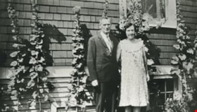
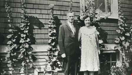
Joe and Mina Wright
https://search.heritageburnaby.ca/link/archivedescription35405
- Repository
- City of Burnaby Archives
- Date
- 1929 (date of original), copied 1986
- Collection/Fonds
- Burnaby Historical Society fonds
- Description Level
- Item
- Physical Description
- 1 photograph : b&w ; 12.7 x 17.8 cm print
- Scope and Content
- Photograph of Joseph "Joe" Wright and wife Wilhelmina "Mina" Wright (nee Williams) in front of the family home at 3935 Pender Street in Vancouver Heights.
- Repository
- City of Burnaby Archives
- Date
- 1929 (date of original), copied 1986
- Collection/Fonds
- Burnaby Historical Society fonds
- Subseries
- Pioneer Tales subseries
- Physical Description
- 1 photograph : b&w ; 12.7 x 17.8 cm print
- Description Level
- Item
- Record No.
- 204-262
- Access Restriction
- No restrictions
- Reproduction Restriction
- No known restrictions
- Accession Number
- BHS1988-03
- Scope and Content
- Photograph of Joseph "Joe" Wright and wife Wilhelmina "Mina" Wright (nee Williams) in front of the family home at 3935 Pender Street in Vancouver Heights.
- Media Type
- Photograph
- Notes
- Title based on contents of photograph
- Geographic Access
- Pender Street
- Street Address
- 3935 Pender Street
- Historic Neighbourhood
- Vancouver Heights (Historic Neighbourhood)
- Planning Study Area
- Willingdon Heights Area
Images

John & Jessie MacLean Residence
https://search.heritageburnaby.ca/link/landmark608
- Repository
- Burnaby Heritage Planning
- Description
- Residential building.
- Associated Dates
- c.1926
- Street View URL
- Google Maps Street View
- Repository
- Burnaby Heritage Planning
- Geographic Access
- Pandora Street
- Associated Dates
- c.1926
- Description
- Residential building.
- Heritage Value
- This cottage illustrates the traditionalism of the interwar years, when domestic ideals were expressed through modest homes displaying period revival influences. Reflecting the influence of the British Arts and Crafts movement, it features a symmetrical plan, a side jerkin-headed roof, a gabled front dormer and twin-coursed shingle siding, and retains its original wooden-sash windows with unusual multi-paned upper sash. It was built for John R. and Jessie MacLean. The house was recently restored by the owners.
- Locality
- Vancouver Heights
- Historic Neighbourhood
- Vancouver Heights (Historic Neighbourhood)
- Planning Study Area
- Burnaby Heights Area
- Area
- 566.71
- Contributing Resource
- Building
- Ownership
- Private
- Street Address
- 3827 Pandora Street
- Street View URL
- Google Maps Street View
Images


Kitchener Elementary School
https://search.heritageburnaby.ca/link/landmark614
- Repository
- Burnaby Heritage Planning
- Description
- School building.
- Associated Dates
- 1925
- Street View URL
- Google Maps Street View
- Repository
- Burnaby Heritage Planning
- Geographic Access
- Gilmore Avenue
- Associated Dates
- 1925
- Description
- School building.
- Heritage Value
- This landmark school was designed by the architectural firm of Bowman & Cullerne, specialists in the design of educational facilities. After Harold Cullerne (1890-1976) returned from service during the First World War, he joined J.H. Bowman (1864-1943) in a partnership that lasted from 1919 to 1934. The firm’s projects include the Seaforth School (1922, now relocated to Burnaby Village Museum), Burnaby North High School (1923), and the Nelson Avenue School (1927). This was originally designed as a two-storey, four-room building in 1925, with two-storey four-room wings added two years later. The building has been altered with the addition of stucco cladding over the original siding and replacement windows, but has retained its original form and massing, as well as its domed roof ventilator.
- Locality
- Vancouver Heights
- Historic Neighbourhood
- Vancouver Heights (Historic Neighbourhood)
- Planning Study Area
- Willingdon Heights Area
- Architect
- Bowman & Cullerne
- Area
- 20478.11
- Contributing Resource
- Building
- Street Address
- 1351 Gilmore Avenue
- Street View URL
- Google Maps Street View
Images

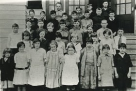
Kitchener Street School class
https://search.heritageburnaby.ca/link/archivedescription35264
- Repository
- City of Burnaby Archives
- Date
- 1926 (date of original), copied 1986
- Collection/Fonds
- Burnaby Historical Society fonds
- Description Level
- Item
- Physical Description
- 1 photograph : b&w ; 12.7 x 17.8 cm print
- Scope and Content
- Photograph of Kitchener School class. Keith Hartney is in the fourth row on the far left.
- Repository
- City of Burnaby Archives
- Date
- 1926 (date of original), copied 1986
- Collection/Fonds
- Burnaby Historical Society fonds
- Subseries
- Pioneer Tales subseries
- Physical Description
- 1 photograph : b&w ; 12.7 x 17.8 cm print
- Description Level
- Item
- Record No.
- 204-121
- Access Restriction
- No restrictions
- Reproduction Restriction
- No known restrictions
- Accession Number
- BHS1988-03
- Scope and Content
- Photograph of Kitchener School class. Keith Hartney is in the fourth row on the far left.
- Media Type
- Photograph
- Notes
- Title based on contents of photograph
- Geographic Access
- Gilmore Avenue
- Street Address
- 1351 Gilmore Avenue
- Historic Neighbourhood
- Vancouver Heights (Historic Neighbourhood)
- Planning Study Area
- Willingdon Heights Area
Images

![Lloyd and Doug Cary on a motorbike, [1929] (date of original), copied 1991 thumbnail](/media/hpo/_Data/_Archives_Images/_Unrestricted/370/370-217.jpg?width=280)
Lloyd and Doug Cary on a motorbike
https://search.heritageburnaby.ca/link/archivedescription37629
- Repository
- City of Burnaby Archives
- Date
- [1929] (date of original), copied 1991
- Collection/Fonds
- Burnaby Historical Society fonds
- Description Level
- Item
- Physical Description
- 1 photograph : b&w ; 3.2 x 5.3 cm print on contact sheet 20.2 x 25.3 cm
- Scope and Content
- Photograph of Lloyd and Doug Cary on an Indian motorbike, on Madison Avenue at the corner of Albert Street (in front of 311 Madison Avenue).
- Repository
- City of Burnaby Archives
- Date
- [1929] (date of original), copied 1991
- Collection/Fonds
- Burnaby Historical Society fonds
- Subseries
- Burnaby Image Bank subseries
- Physical Description
- 1 photograph : b&w ; 3.2 x 5.3 cm print on contact sheet 20.2 x 25.3 cm
- Description Level
- Item
- Record No.
- 370-217
- Access Restriction
- No restrictions
- Reproduction Restriction
- No known restrictions
- Accession Number
- BHS1999-03
- Scope and Content
- Photograph of Lloyd and Doug Cary on an Indian motorbike, on Madison Avenue at the corner of Albert Street (in front of 311 Madison Avenue).
- Subjects
- Transportation - Motorcycles
- Names
- Cary, Doug
- Cary, Lloyd
- Media Type
- Photograph
- Notes
- Title based on contents of photograph
- 1 b&w copy negative accompanying
- Geographic Access
- Madison Avenue
- Street Address
- 311 Madison Avenue
- Historic Neighbourhood
- Vancouver Heights (Historic Neighbourhood)
- Planning Study Area
- Burnaby Heights Area
Images
![Lloyd and Doug Cary on a motorbike, [1929] (date of original), copied 1991 thumbnail](/media/hpo/_Data/_Archives_Images/_Unrestricted/370/370-217.jpg)
![Mary Warren and Bill Anthony, [192-] (date of original), copied 1986 thumbnail](/media/hpo/_Data/_Archives_Images/_Unrestricted/204/204-404.jpg?width=280)
Mary Warren and Bill Anthony
https://search.heritageburnaby.ca/link/archivedescription35546
- Repository
- City of Burnaby Archives
- Date
- [192-] (date of original), copied 1986
- Collection/Fonds
- Burnaby Historical Society fonds
- Description Level
- Item
- Physical Description
- 1 photograph : b&w ; 12.7 x 17.8 cm print
- Scope and Content
- Photograph of Mary Warren and Bill Anthony, west of the Warren family home at 4264 Union Street. The street did not extend past the Warren house. A "corduroy" road was used in the early years: split cedar logs placed side by side.
- Repository
- City of Burnaby Archives
- Date
- [192-] (date of original), copied 1986
- Collection/Fonds
- Burnaby Historical Society fonds
- Subseries
- Pioneer Tales subseries
- Physical Description
- 1 photograph : b&w ; 12.7 x 17.8 cm print
- Description Level
- Item
- Record No.
- 204-404
- Access Restriction
- No restrictions
- Reproduction Restriction
- No known restrictions
- Accession Number
- BHS1988-03
- Scope and Content
- Photograph of Mary Warren and Bill Anthony, west of the Warren family home at 4264 Union Street. The street did not extend past the Warren house. A "corduroy" road was used in the early years: split cedar logs placed side by side.
- Media Type
- Photograph
- Notes
- Title based on contents of photograph
- Geographic Access
- Union Street
- Street Address
- 4264 Union Street
- Historic Neighbourhood
- Vancouver Heights (Historic Neighbourhood)
- Planning Study Area
- Willingdon Heights Area
Images
![Mary Warren and Bill Anthony, [192-] (date of original), copied 1986 thumbnail](/media/hpo/_Data/_Archives_Images/_Unrestricted/204/204-404.jpg)

Masonic Cemetery
https://search.heritageburnaby.ca/link/landmark622
- Repository
- Burnaby Heritage Planning
- Description
- Cemetery site.
- Associated Dates
- 1924
- Street View URL
- Google Maps Street View
- Repository
- Burnaby Heritage Planning
- Geographic Access
- Halifax Street
- Associated Dates
- 1924
- Description
- Cemetery site.
- Heritage Value
- Tucked into a sloping site in a zone that is now transitional between light industrial and residential uses, the Masonic Cemetery is a beautifully landscaped oasis. Two outstanding features of this cemetery are the Woodward mausoleum, constructed in 1924, and the 1930s entrance gates. These substantial gates are constructed of random-coursed granite, and mark the cemetery’s main entrance off Douglas Road. An elaborate granite mausoleum, built for the prominent Woodward family, is located on axis with the main entry, at the brow of the slope. The Egyptian Revival style of the mausoleum was inspired by the opening of Tutankamun’s tomb just two years earlier, a discovery that sparked world-wide Egyptomania. The Woodward’s department store dynasty was founded by Charles Woodward (1852-1937), who visited Vancouver in 1891 and bought two lots for a store. Woodward’s drug department opened in 1895. In 1901, he took an option on a lot at the corner of Hastings and Abbott Streets and incorporated as Woodward’s Department Stores, which opened in November 1903. The family continued to run the business until 1993, when it went bankrupt and was sold to the Hudson’s Bay Company. A number of the Woodward family are interred here.
- Locality
- Vancouver Heights
- Historic Neighbourhood
- Vancouver Heights (Historic Neighbourhood)
- Planning Study Area
- Willingdon Heights Area
- Area
- 60137.87
- Contributing Resource
- Building
- Landscape Feature
- Ownership
- Private
- Street Address
- 4305 Halifax Street
- Street View URL
- Google Maps Street View
Images


![Masonic Hall, [1920] (date of original), copied 1986 thumbnail](/media/hpo/_Data/_Archives_Images/_Unrestricted/204/204-289.jpg?width=280)
Masonic Hall
https://search.heritageburnaby.ca/link/archivedescription35431
- Repository
- City of Burnaby Archives
- Date
- [1920] (date of original), copied 1986
- Collection/Fonds
- Burnaby Historical Society fonds
- Description Level
- Item
- Physical Description
- 1 photograph : b&w ; 12.7 x 17.8 cm print
- Scope and Content
- Photograph of 4015 Triumph Street, Vancouver Heights Presbyterian Church at the corner of MacDonald Avenue and Triumph Street, with people playing tennis in the adjoining tennis court. The Hall's basement was used by overcrowded Gilmore School for classes and was also used for first Burnaby North h…
- Repository
- City of Burnaby Archives
- Date
- [1920] (date of original), copied 1986
- Collection/Fonds
- Burnaby Historical Society fonds
- Subseries
- Pioneer Tales subseries
- Physical Description
- 1 photograph : b&w ; 12.7 x 17.8 cm print
- Description Level
- Item
- Record No.
- 204-289
- Access Restriction
- No restrictions
- Reproduction Restriction
- No restrictions
- Accession Number
- BHS1988-03
- Scope and Content
- Photograph of 4015 Triumph Street, Vancouver Heights Presbyterian Church at the corner of MacDonald Avenue and Triumph Street, with people playing tennis in the adjoining tennis court. The Hall's basement was used by overcrowded Gilmore School for classes and was also used for first Burnaby North high school classes before Burnaby North High School was built. It later became the Zenith Masonic Hall.
- Names
- Burnaby North High School
- Gilmore Avenue School
- Masonic Hall
- Vancouver Heights Presbyterian Church
- Media Type
- Photograph
- Photographer
- Eaton, Dr. Carl
- Notes
- Title based on contents of photograph
- Geographic Access
- Triumph Street
- Street Address
- 4015 Triumph Street
- Historic Neighbourhood
- Vancouver Heights (Historic Neighbourhood)
- Planning Study Area
- Burnaby Heights Area
Images
![Masonic Hall, [1920] (date of original), copied 1986 thumbnail](/media/hpo/_Data/_Archives_Images/_Unrestricted/204/204-289.jpg)
![Miss Scott's class at Vancouver Heights Public School, [after 1912] thumbnail](/media/hpo/_Data/_BVM_Images/1985/198900190001.jpg?width=280)
Miss Scott's class at Vancouver Heights Public School
https://search.heritageburnaby.ca/link/museumdescription72
- Repository
- Burnaby Village Museum
- Date
- [after 1912]
- Collection/Fonds
- Burnaby Village Museum Photograph collection
- Description Level
- Item
- Physical Description
- 1 photograph : sepia ; 10 x 15 cm mounted on card 18 x 23 cm
- Scope and Content
- Photograph of Miss Scott's class taken on the steps of Vancouver Heights Public School. The students are standing in seven rows and Miss Scott is standing on the left at the end of the second row.
- Repository
- Burnaby Village Museum
- Collection/Fonds
- Burnaby Village Museum Photograph collection
- Description Level
- Item
- Physical Description
- 1 photograph : sepia ; 10 x 15 cm mounted on card 18 x 23 cm
- Scope and Content
- Photograph of Miss Scott's class taken on the steps of Vancouver Heights Public School. The students are standing in seven rows and Miss Scott is standing on the left at the end of the second row.
- Subjects
- Occupations - Teachers
- Geographic Access
- Gilmore Avenue
- Street Address
- 50 Gilmore Avenue
- Accession Code
- BV989.19.1
- Access Restriction
- No restrictions
- Date
- [after 1912]
- Media Type
- Photograph
- Historic Neighbourhood
- Vancouver Heights (Historic Neighbourhood)
- Planning Study Area
- Burnaby Heights Area
- Scan Resolution
- 600
- Scan Date
- 01-Jun-09
- Scale
- 100
- Photographer
- McConnell, W. F.
- Notes
- Title based on contents of photograph
- Note written in pencil on verso of card mount reads: "R. G. McManus/ 4257 Dundas St [top two lines crossed out]/ North Burnaby B.C" and "c/o Terry Lynn Callender/ TEACHER MISS SCOTT"
- Note written in pen on verso of card mount reads: "AS OF FEB 28/85/ DAVID L. McMANUS/ [address follows]"
- Embossed letters on the card mount reads: "W. F. McConnell/ VANCOUVER, B.C."
Images
![Miss Scott's class at Vancouver Heights Public School, [after 1912] thumbnail](/media/hpo/_Data/_BVM_Images/1985/198900190001.jpg)
![Mr. Porter and Jack Greer, [between 1920 and 1924] (date of original), copied 1991 thumbnail](/media/hpo/_Data/_Archives_Images/_Unrestricted/370/370-143.jpg?width=280)
Mr. Porter and Jack Greer
https://search.heritageburnaby.ca/link/archivedescription37555
- Repository
- City of Burnaby Archives
- Date
- [between 1920 and 1924] (date of original), copied 1991
- Collection/Fonds
- Burnaby Historical Society fonds
- Description Level
- Item
- Physical Description
- 1 photograph : b&w ; 4.1 x 3.0 cm print on contact sheet 20.2 x 25.3 cm
- Scope and Content
- Photograph of (left to right) Mr. Porter and Jack Greer standing in front of a car in front of Mr. Porter's house on the 4200 block of Oxford Street.
- Repository
- City of Burnaby Archives
- Date
- [between 1920 and 1924] (date of original), copied 1991
- Collection/Fonds
- Burnaby Historical Society fonds
- Subseries
- Burnaby Image Bank subseries
- Physical Description
- 1 photograph : b&w ; 4.1 x 3.0 cm print on contact sheet 20.2 x 25.3 cm
- Description Level
- Item
- Record No.
- 370-143
- Access Restriction
- No restrictions
- Reproduction Restriction
- No restrictions
- Accession Number
- BHS1999-03
- Scope and Content
- Photograph of (left to right) Mr. Porter and Jack Greer standing in front of a car in front of Mr. Porter's house on the 4200 block of Oxford Street.
- Subjects
- Transportation - Automobiles
- Names
- Greer, Jack
- Media Type
- Photograph
- Notes
- Title based on contents of photograph
- 1 b&w copy negative accompanying
- Geographic Access
- Oxford Street
- Historic Neighbourhood
- Vancouver Heights (Historic Neighbourhood)
- Planning Study Area
- Burnaby Heights Area
Images
![Mr. Porter and Jack Greer, [between 1920 and 1924] (date of original), copied 1991 thumbnail](/media/hpo/_Data/_Archives_Images/_Unrestricted/370/370-143.jpg)
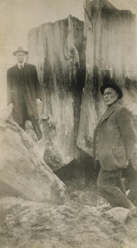
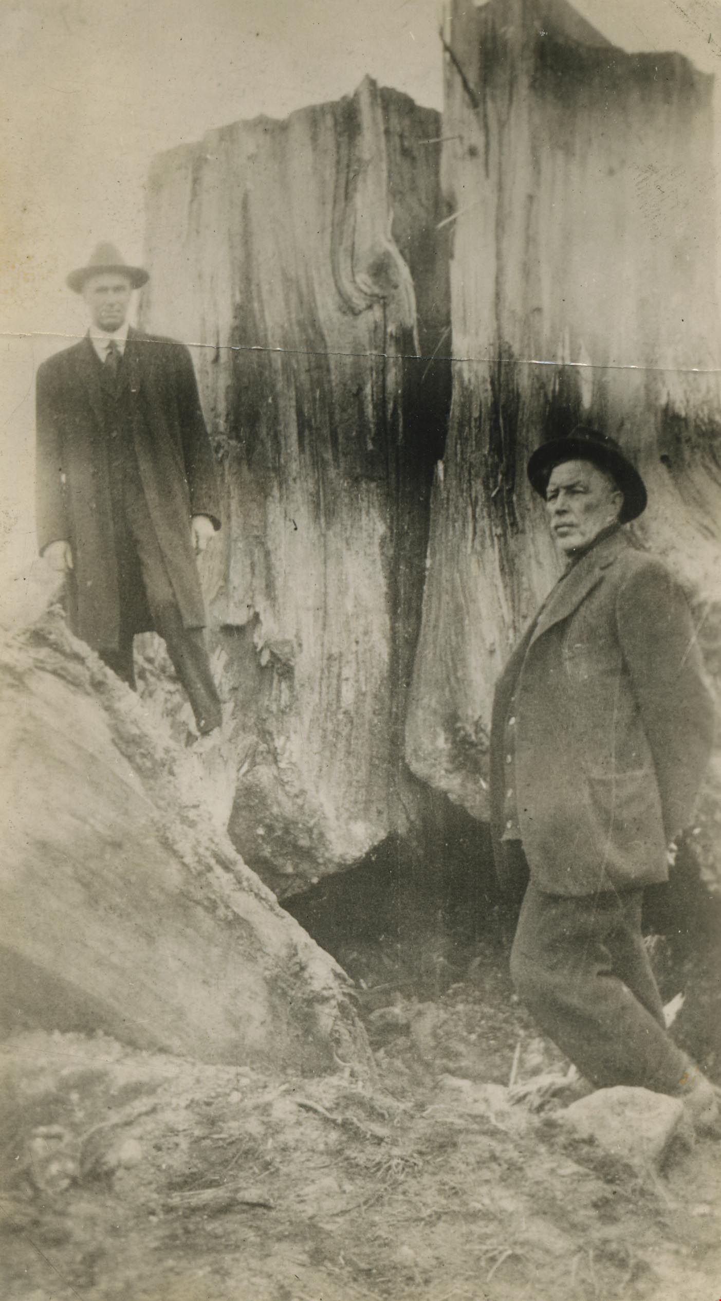
Mr. Tough and G.L. Lawson beside a tree stump
https://search.heritageburnaby.ca/link/archivedescription38544
- Repository
- City of Burnaby Archives
- Date
- 1921
- Collection/Fonds
- Burnaby Historical Society fonds
- Description Level
- Item
- Physical Description
- 1 photograph : b&w ; 6 x 10.8 cm
- Scope and Content
- Photograph of two men standing next to a large tree stump. A note written on the back of the photograph reads: " Stump blasted out by William Tough, street sup't [sic] in 1921. It stood on the boulevard on the south side of Hastings Street a few feet East of Ingleton. At left Councillor G. L. La…
- Repository
- City of Burnaby Archives
- Date
- 1921
- Collection/Fonds
- Burnaby Historical Society fonds
- Subseries
- New Westminster Public Library subseries
- Physical Description
- 1 photograph : b&w ; 6 x 10.8 cm
- Description Level
- Item
- Record No.
- 459-004
- Access Restriction
- No restrictions
- Reproduction Restriction
- No known restrictions
- Accession Number
- BHS2003-19
- Scope and Content
- Photograph of two men standing next to a large tree stump. A note written on the back of the photograph reads: " Stump blasted out by William Tough, street sup't [sic] in 1921. It stood on the boulevard on the south side of Hastings Street a few feet East of Ingleton. At left Councillor G. L. Lawson. Right, Mr. Tough." Councillor Lawson served on council from 1919-1920 and again from 1922-1923.
- Media Type
- Photograph
- Notes
- Title based on caption
- Geographic Access
- Hastings Street
- Ingleton Avenue
- Street Address
- 3900 Hastings Street
- Historic Neighbourhood
- Vancouver Heights (Historic Neighbourhood)
- Planning Study Area
- Willingdon Heights Area
Images

Municipality of Burnaby - Volume XV and Volume XVIII
https://search.heritageburnaby.ca/link/museumdescription8680
- Repository
- Burnaby Village Museum
- Date
- May 1927
- Collection/Fonds
- Burnaby Village Museum Map collection
- Description Level
- File
- Physical Description
- 4 plans on 4 sheets : col. lithographic prints ; 63.5 x 53.5 cm folded to 53 x 31.5 cm
- Scope and Content
- File consists of four pages of plans removed from a bound book containing a series of fire insurance plans of the Municipality of Burnaby. The first two pages are numbered "A" and "B" and are key plans from "GREATER VANCOUVER B.C. / VOLUME XV / Surveyed _ May 1927 / MUNICIPALITY OF / BURNABY", "PLA…
- Repository
- Burnaby Village Museum
- Collection/Fonds
- Burnaby Village Museum Map collection
- Description Level
- File
- Physical Description
- 4 plans on 4 sheets : col. lithographic prints ; 63.5 x 53.5 cm folded to 53 x 31.5 cm
- Material Details
- Scales [1:1200] and [1:6000]
- Scope and Content
- File consists of four pages of plans removed from a bound book containing a series of fire insurance plans of the Municipality of Burnaby. The first two pages are numbered "A" and "B" and are key plans from "GREATER VANCOUVER B.C. / VOLUME XV / Surveyed _ May 1927 / MUNICIPALITY OF / BURNABY", "PLAN DEPT. FIRE BRANCH _ B.C. INSURANCE UNDERWRITERS ASSN.". Key Plan "B" covers plans: 1505; 1506; 1512 to 1516; 1540 to 1544; 1550 to 1557 and District Lots: 129 to 132; 135 to 138; 205 to 208 and 215 to 218. Key Plan "A" covers plans: 1501 to 1504; 1507 to 1511; 1517 to 1525; 1531 to 1539; 1545 to 1550 and District Lots: 116 to 127 and 186 to 189. Plan "1806" is part of "GREATER VANCOUVER B.C. / VOLUME XVIII / Municipality of Burnaby / May, 1927" and covers District Lot 153. Plan "1807" is from "GREATER VANCOUVER B.C. / VOLUME XVIII / Municipality of Burnaby / May, 1927" and covers District Lots: 99,149 and 152.
- Responsibility
- British Columbia Underwriters' Association
- Accession Code
- HV972.111.2
- Access Restriction
- No restrictions
- Reproduction Restriction
- May be restricted by third party rights
- Date
- May 1927
- Media Type
- Cartographic Material
- Historic Neighbourhood
- Vancouver Heights (Historic Neighbourhood)
- Lochdale (Historic Neighbourhood)
- Capitol Hill (Historic Neighbourhood)
- Central Park (Historic Neighbourhood)
- Alta Vista (Historic Neighbourhood)
- Planning Study Area
- Burnaby Heights Area
- Sperling-Broadway Area
- Lochdale Area
- Parkcrest-Aubrey Area
- Westridge Area
- Willingdon Heights Area
- Capitol Hill Area
- Maywood Area
- Marlborough Area
- Scan Resolution
- 400
- Scan Date
- 2021-11-18
- Notes
- Title based on content of plans
- Scales are measured 1 inch = 100 feet and 1 inch = 500 feet
- See also BV987.1.70d for revised versions of plans
Zoomable Images


Municipality of Burnaby - Volume XV and Volume XVIII
https://search.heritageburnaby.ca/link/museumdescription8681
- Repository
- Burnaby Village Museum
- Date
- May 1927
- Collection/Fonds
- Burnaby Village Museum Map collection
- Description Level
- File
- Physical Description
- 4 plans on 4 sheets : col. lithographic prints, ms. annotations in blue ink ; 63.5 x 53.5 cm folded to 53 x 31.5 cm
- Scope and Content
- File consists of four pages of plans removed from a bound book containing a series of fire insurance plans of the Municipality of Burnaby. Plan "1507" and plan "1517" are from "GREATER VANCOUVER B.C. / VOLUME XV / Municipality of Burnaby / May, 1927". Plan "1507" covers District Lot 186 and plan "1…
- Repository
- Burnaby Village Museum
- Collection/Fonds
- Burnaby Village Museum Map collection
- Description Level
- File
- Physical Description
- 4 plans on 4 sheets : col. lithographic prints, ms. annotations in blue ink ; 63.5 x 53.5 cm folded to 53 x 31.5 cm
- Material Details
- Scale [1:600] and [1:1200]
- Scope and Content
- File consists of four pages of plans removed from a bound book containing a series of fire insurance plans of the Municipality of Burnaby. Plan "1507" and plan "1517" are from "GREATER VANCOUVER B.C. / VOLUME XV / Municipality of Burnaby / May, 1927". Plan "1507" covers District Lot 186 and plan "1517" covers District Lot 116. Plan "1804" and plan "1805" are from "GREATER VANCOUVER B.C. / VOLUME XVIII / Municipality of Burnaby / May, 1927". Plans "1804" and "1805" cover District Lot 153.
- Responsibility
- British Columbia Underwriters' Association
- Accession Code
- HV972.111.3
- Access Restriction
- No restrictions
- Reproduction Restriction
- May be restricted by third party rights
- Date
- May 1927
- Media Type
- Cartographic Material
- Historic Neighbourhood
- Central Park (Historic Neighbourhood)
- Vancouver Heights (Historic Neighbourhood)
- Planning Study Area
- Maywood Area
- Willingdon Heights Area
- Scan Resolution
- 400
- Scan Date
- 2021-11-18
- Notes
- Title based on content of plans
- See also BV987.1.70d for revised versions of plans
- Scale is measured 1 inch = 100 feet
Images


