Narrow Results By

François & Cezarie Comeau Residence
https://search.heritageburnaby.ca/link/landmark580
- Repository
- Burnaby Heritage Planning
- Description
- Residential building.
- Associated Dates
- c.1925
- Street View URL
- Google Maps Street View
- Repository
- Burnaby Heritage Planning
- Geographic Access
- Esmond Avenue
- Associated Dates
- c.1925
- Description
- Residential building.
- Heritage Value
- This home was built for Francois Xavier “Frank” Comeau (1863-1943), a blacksmith who moved from Quebec to Vancouver in about 1890, and his wife Cezarie Marie (née Fortin, 1860-1950), also from Quebec, whom he married in 1903. Featuring a front gabled roof with decorative triangular eave brackets, this comfortable Craftsman bungalow displays other characteristics typical of the style such as lapped siding at the foundation, a shingle-clad main floor, casement windows and stained glass transoms on the front elevation. The most notable feature of the plan is the inset verandah with subtle segmental-arched openings and tapered square columns.
- Locality
- Vancouver Heights
- Historic Neighbourhood
- Vancouver Heights (Historic Neighbourhood)
- Planning Study Area
- Burnaby Heights Area
- Area
- 566.71
- Contributing Resource
- Building
- Ownership
- Private
- Street Address
- 306 Esmond Avenue
- Street View URL
- Google Maps Street View
Images

![Brown-John home, [192-] (date of original), digitally copied 2012 thumbnail](/media/hpo/_Data/_Archives_Images/_Unrestricted/540/549-007.jpg?width=280)
Brown-John home
https://search.heritageburnaby.ca/link/archivedescription76890
- Repository
- City of Burnaby Archives
- Date
- [192-] (date of original), digitally copied 2012
- Collection/Fonds
- Community Heritage Commission Special Projects fonds
- Description Level
- Item
- Physical Description
- 1 photograph (jpeg) : col. ; 300ppi
- Scope and Content
- Photograph of the Brown-John home in Burnaby. Four large trucks are visible parked in front of the house.
- Repository
- City of Burnaby Archives
- Date
- [192-] (date of original), digitally copied 2012
- Collection/Fonds
- Community Heritage Commission Special Projects fonds
- Physical Description
- 1 photograph (jpeg) : col. ; 300ppi
- Description Level
- Item
- Record No.
- 549-007
- Access Restriction
- No restrictions
- Reproduction Restriction
- No known restrictions
- Accession Number
- 2012-30
- Scope and Content
- Photograph of the Brown-John home in Burnaby. Four large trucks are visible parked in front of the house.
- Media Type
- Photograph
- Notes
- Title based on contents of photograph
- Geographic Access
- Hastings Street
- Historic Neighbourhood
- Vancouver Heights (Historic Neighbourhood)
- Planning Study Area
- Willingdon Heights Area
Images
![Brown-John home, [192-] (date of original), digitally copied 2012 thumbnail](/media/hpo/_Data/_Archives_Images/_Unrestricted/540/549-007.jpg)
![East Hastings Street stores, [1929] thumbnail](/media/hpo/_Data/_Archives_Images/_Unrestricted/371/476-018.jpg?width=280)
East Hastings Street stores
https://search.heritageburnaby.ca/link/archivedescription38675
- Repository
- City of Burnaby Archives
- Date
- [1929]
- Collection/Fonds
- Burnaby Historical Society fonds
- Description Level
- Item
- Physical Description
- 1 photograph : sepia ; 8.5 x 13.8 cm
- Scope and Content
- Photograph of storefronts along East Hastings Street. To the right, the sign for Kidd & Co. Hardware store can be seen while posters for the Western Glass Company are in the windows of the building featured in the centre of the photograph. An unidentified man is standing in the doorway of the store…
- Repository
- City of Burnaby Archives
- Date
- [1929]
- Collection/Fonds
- Burnaby Historical Society fonds
- Subseries
- North Burnaby Board of Trade subseries
- Physical Description
- 1 photograph : sepia ; 8.5 x 13.8 cm
- Description Level
- Item
- Record No.
- 476-018
- Access Restriction
- No restrictions
- Reproduction Restriction
- No known restrictions
- Accession Number
- BHS2005-8
- Scope and Content
- Photograph of storefronts along East Hastings Street. To the right, the sign for Kidd & Co. Hardware store can be seen while posters for the Western Glass Company are in the windows of the building featured in the centre of the photograph. An unidentified man is standing in the doorway of the store and two cars are parked along the street.
- Subjects
- Buildings - Commercial - Stores
- Media Type
- Photograph
- Notes
- Title based on contents of photograph
- Geographic Access
- Hastings Street
- Street Address
- 3736 Hastings Street
- Historic Neighbourhood
- Vancouver Heights (Historic Neighbourhood)
- Planning Study Area
- Burnaby Heights Area
Images
![East Hastings Street stores, [1929] thumbnail](/media/hpo/_Data/_Archives_Images/_Unrestricted/371/476-018.jpg)
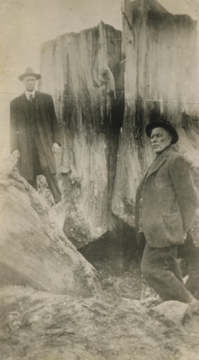
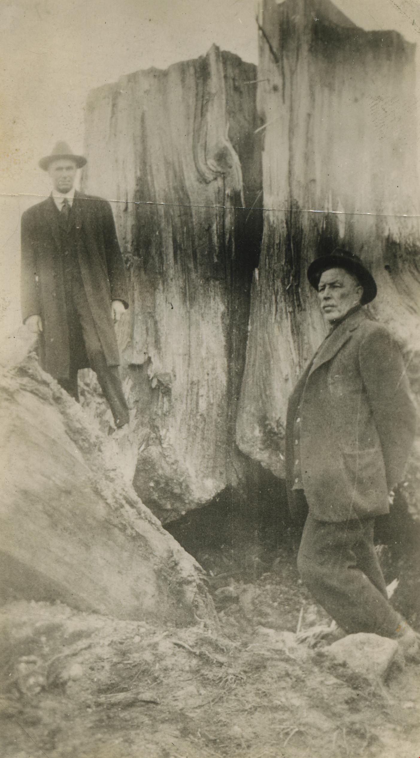
Mr. Tough and G.L. Lawson beside a tree stump
https://search.heritageburnaby.ca/link/archivedescription38544
- Repository
- City of Burnaby Archives
- Date
- 1921
- Collection/Fonds
- Burnaby Historical Society fonds
- Description Level
- Item
- Physical Description
- 1 photograph : b&w ; 6 x 10.8 cm
- Scope and Content
- Photograph of two men standing next to a large tree stump. A note written on the back of the photograph reads: " Stump blasted out by William Tough, street sup't [sic] in 1921. It stood on the boulevard on the south side of Hastings Street a few feet East of Ingleton. At left Councillor G. L. La…
- Repository
- City of Burnaby Archives
- Date
- 1921
- Collection/Fonds
- Burnaby Historical Society fonds
- Subseries
- New Westminster Public Library subseries
- Physical Description
- 1 photograph : b&w ; 6 x 10.8 cm
- Description Level
- Item
- Record No.
- 459-004
- Access Restriction
- No restrictions
- Reproduction Restriction
- No known restrictions
- Accession Number
- BHS2003-19
- Scope and Content
- Photograph of two men standing next to a large tree stump. A note written on the back of the photograph reads: " Stump blasted out by William Tough, street sup't [sic] in 1921. It stood on the boulevard on the south side of Hastings Street a few feet East of Ingleton. At left Councillor G. L. Lawson. Right, Mr. Tough." Councillor Lawson served on council from 1919-1920 and again from 1922-1923.
- Media Type
- Photograph
- Notes
- Title based on caption
- Geographic Access
- Hastings Street
- Ingleton Avenue
- Street Address
- 3900 Hastings Street
- Historic Neighbourhood
- Vancouver Heights (Historic Neighbourhood)
- Planning Study Area
- Willingdon Heights Area
Images

Opening of the Hastings-Barnet Road
https://search.heritageburnaby.ca/link/archivedescription38660
- Repository
- City of Burnaby Archives
- Date
- 1927
- Collection/Fonds
- Burnaby Historical Society fonds
- Description Level
- Item
- Physical Description
- 1 photograph : sepia ; 17.5 x 26.5 cm
- Scope and Content
- Photograph of the official opening of the newly paved Hastings-Barnet Road which opened on Saturday December 10, 1927. In the foreground the Provincial Minister of Public Works Dr. W.H. Sutherland is opening a wooden gate, with a large crowd gathered around. The Barnet Lumber Company Ltd. building …
- Repository
- City of Burnaby Archives
- Date
- 1927
- Collection/Fonds
- Burnaby Historical Society fonds
- Subseries
- North Burnaby Board of Trade subseries
- Physical Description
- 1 photograph : sepia ; 17.5 x 26.5 cm
- Description Level
- Item
- Record No.
- 476-003
- Access Restriction
- No restrictions
- Reproduction Restriction
- No known restrictions
- Accession Number
- BHS2005-8
- Scope and Content
- Photograph of the official opening of the newly paved Hastings-Barnet Road which opened on Saturday December 10, 1927. In the foreground the Provincial Minister of Public Works Dr. W.H. Sutherland is opening a wooden gate, with a large crowd gathered around. The Barnet Lumber Company Ltd. building on Hastings Street is in the background.
- Subjects
- Geographic Features - Roads
- Persons - Crowds
- Buildings - Industrial - Mills
- Officials - Elected Officials
- Public Services - Public Works
- Names
- Barnet Mill
- Sutherland, W.H.
- Media Type
- Photograph
- Notes
- Title based on contents of photograph
- Geographic Access
- Hastings Street
- Street Address
- 3995 Hastings Street
- Historic Neighbourhood
- Vancouver Heights (Historic Neighbourhood)
- Planning Study Area
- Burnaby Heights Area
Images

![Vancouver Heights, [1921] (date of original), copied 1986 thumbnail](/media/hpo/_Data/_Archives_Images/_Unrestricted/204/204-302.jpg?width=280)
Vancouver Heights
https://search.heritageburnaby.ca/link/archivedescription35444
- Repository
- City of Burnaby Archives
- Date
- [1921] (date of original), copied 1986
- Collection/Fonds
- Burnaby Historical Society fonds
- Description Level
- Item
- Physical Description
- 1 photograph : b&w ; 12.7 x 17.8 cm print
- Scope and Content
- Photograph of the Vancouver Heights area, with Burrard Inlet in background, taken from Triumph Street and Esmond Avenue looking northwest. In the centre of the photograph is the Wilks house at 3707 Dundas Street, with the light-coloured house in the middle being 3738 Dundas Street.
- Repository
- City of Burnaby Archives
- Date
- [1921] (date of original), copied 1986
- Collection/Fonds
- Burnaby Historical Society fonds
- Subseries
- Pioneer Tales subseries
- Physical Description
- 1 photograph : b&w ; 12.7 x 17.8 cm print
- Description Level
- Item
- Record No.
- 204-302
- Access Restriction
- No restrictions
- Reproduction Restriction
- No known restrictions
- Accession Number
- BHS1988-03
- Scope and Content
- Photograph of the Vancouver Heights area, with Burrard Inlet in background, taken from Triumph Street and Esmond Avenue looking northwest. In the centre of the photograph is the Wilks house at 3707 Dundas Street, with the light-coloured house in the middle being 3738 Dundas Street.
- Subjects
- Buildings - Residential - Houses
- Media Type
- Photograph
- Notes
- Title based on contents of photograph
- Annotation under photograph reads, "Vancouver Hts & Burrard Inlet / 1921"
- Geographic Access
- Triumph Street
- Dundas Street
- Esmond Avenue
- Street Address
- 3707 Dundas Street
- 3738 Dundas Street
- Historic Neighbourhood
- Vancouver Heights (Historic Neighbourhood)
- Planning Study Area
- Burnaby Heights Area
Images
![Vancouver Heights, [1921] (date of original), copied 1986 thumbnail](/media/hpo/_Data/_Archives_Images/_Unrestricted/204/204-302.jpg)