Narrow Results By
Subject
- Agriculture - Farms 1
- Animals - Dogs 2
- Animals - Poultry 1
- Buildings - Civic - Fire Halls 1
- Buildings - Commercial - Stores 1
- Buildings - Heritage 1
- Buildings - Industrial - Mills 1
- Buildings - Religious - Churches 4
- Buildings - Residential - Houses 13
- Buildings - Schools 9
- Ceremonies - Graduations 1
- Clothing - Uniforms 2

Crabtown
https://search.heritageburnaby.ca/link/landmark674
- Repository
- Burnaby Heritage Planning
- Associated Dates
- 1912-1957
- Heritage Value
- North Burnaby's waterfront was the location of a unique squatter's community known as Crabtown. Although its origins are obscure, it is believed that the first shacks were built before 1912. When the depression of 1913-1917 began, the shacks became permanent homes for impoverished workers. During the Great Depression of the 1930s, the community grew larger. Crabtown was not a slum, but a neighbourhood - the community even rallied together to build a water supply system and trails up the steep bluff with steps and banisters so children could go to school safely. In 1957, the National Harbours Board decided that Crabtown was encroaching on Federal property and evicted all 130 residents. Within a few months, residents were relocated and 114 homes were levelled.
- Historic Neighbourhood
- Vancouver Heights (Historic Neighbourhood)
- Planning Study Area
- Burnaby Heights Area
Images


François & Cezarie Comeau Residence
https://search.heritageburnaby.ca/link/landmark580
- Repository
- Burnaby Heritage Planning
- Description
- Residential building.
- Associated Dates
- c.1925
- Street View URL
- Google Maps Street View
- Repository
- Burnaby Heritage Planning
- Geographic Access
- Esmond Avenue
- Associated Dates
- c.1925
- Description
- Residential building.
- Heritage Value
- This home was built for Francois Xavier “Frank” Comeau (1863-1943), a blacksmith who moved from Quebec to Vancouver in about 1890, and his wife Cezarie Marie (née Fortin, 1860-1950), also from Quebec, whom he married in 1903. Featuring a front gabled roof with decorative triangular eave brackets, this comfortable Craftsman bungalow displays other characteristics typical of the style such as lapped siding at the foundation, a shingle-clad main floor, casement windows and stained glass transoms on the front elevation. The most notable feature of the plan is the inset verandah with subtle segmental-arched openings and tapered square columns.
- Locality
- Vancouver Heights
- Historic Neighbourhood
- Vancouver Heights (Historic Neighbourhood)
- Planning Study Area
- Burnaby Heights Area
- Area
- 566.71
- Contributing Resource
- Building
- Ownership
- Private
- Street Address
- 306 Esmond Avenue
- Street View URL
- Google Maps Street View
Images


George & Rose Nuttall Residence
https://search.heritageburnaby.ca/link/landmark585
- Repository
- Burnaby Heritage Planning
- Description
- Residential building.
- Associated Dates
- 1921
- Other Names
- HILLCREST
- Street View URL
- Google Maps Street View
- Repository
- Burnaby Heritage Planning
- Other Names
- HILLCREST
- Geographic Access
- McGill Street
- Associated Dates
- 1921
- Description
- Residential building.
- Heritage Value
- This house was built for local plumber contractor George Nuttall (1883-1970) and his wife Rose Ann Nuttall (née Clagg, 1881-1955). George continued to live in the house after Rose’s death, until his own death in 1970. Although typical of the Craftsman style and form with its side-gabled roof, triangular eave brackets and front gabled dormer, this house has a number of special details, such as its beautiful art glass transom windows. The front verandah supports are massive stucco columns that contain stained glass lanterns with the house name, Hillcrest, and address.
- Locality
- Vancouver Heights
- Historic Neighbourhood
- Vancouver Heights (Historic Neighbourhood)
- Planning Study Area
- Burnaby Heights Area
- Area
- 566.71
- Contributing Resource
- Building
- Ownership
- Private
- Street Address
- 3756 McGill Street
- Street View URL
- Google Maps Street View
Images


John & Jessie MacLean Residence
https://search.heritageburnaby.ca/link/landmark608
- Repository
- Burnaby Heritage Planning
- Description
- Residential building.
- Associated Dates
- c.1926
- Street View URL
- Google Maps Street View
- Repository
- Burnaby Heritage Planning
- Geographic Access
- Pandora Street
- Associated Dates
- c.1926
- Description
- Residential building.
- Heritage Value
- This cottage illustrates the traditionalism of the interwar years, when domestic ideals were expressed through modest homes displaying period revival influences. Reflecting the influence of the British Arts and Crafts movement, it features a symmetrical plan, a side jerkin-headed roof, a gabled front dormer and twin-coursed shingle siding, and retains its original wooden-sash windows with unusual multi-paned upper sash. It was built for John R. and Jessie MacLean. The house was recently restored by the owners.
- Locality
- Vancouver Heights
- Historic Neighbourhood
- Vancouver Heights (Historic Neighbourhood)
- Planning Study Area
- Burnaby Heights Area
- Area
- 566.71
- Contributing Resource
- Building
- Ownership
- Private
- Street Address
- 3827 Pandora Street
- Street View URL
- Google Maps Street View
Images


Kitchener Elementary School
https://search.heritageburnaby.ca/link/landmark614
- Repository
- Burnaby Heritage Planning
- Description
- School building.
- Associated Dates
- 1925
- Street View URL
- Google Maps Street View
- Repository
- Burnaby Heritage Planning
- Geographic Access
- Gilmore Avenue
- Associated Dates
- 1925
- Description
- School building.
- Heritage Value
- This landmark school was designed by the architectural firm of Bowman & Cullerne, specialists in the design of educational facilities. After Harold Cullerne (1890-1976) returned from service during the First World War, he joined J.H. Bowman (1864-1943) in a partnership that lasted from 1919 to 1934. The firm’s projects include the Seaforth School (1922, now relocated to Burnaby Village Museum), Burnaby North High School (1923), and the Nelson Avenue School (1927). This was originally designed as a two-storey, four-room building in 1925, with two-storey four-room wings added two years later. The building has been altered with the addition of stucco cladding over the original siding and replacement windows, but has retained its original form and massing, as well as its domed roof ventilator.
- Locality
- Vancouver Heights
- Historic Neighbourhood
- Vancouver Heights (Historic Neighbourhood)
- Planning Study Area
- Willingdon Heights Area
- Architect
- Bowman & Cullerne
- Area
- 20478.11
- Contributing Resource
- Building
- Street Address
- 1351 Gilmore Avenue
- Street View URL
- Google Maps Street View
Images


Masonic Cemetery
https://search.heritageburnaby.ca/link/landmark622
- Repository
- Burnaby Heritage Planning
- Description
- Cemetery site.
- Associated Dates
- 1924
- Street View URL
- Google Maps Street View
- Repository
- Burnaby Heritage Planning
- Geographic Access
- Halifax Street
- Associated Dates
- 1924
- Description
- Cemetery site.
- Heritage Value
- Tucked into a sloping site in a zone that is now transitional between light industrial and residential uses, the Masonic Cemetery is a beautifully landscaped oasis. Two outstanding features of this cemetery are the Woodward mausoleum, constructed in 1924, and the 1930s entrance gates. These substantial gates are constructed of random-coursed granite, and mark the cemetery’s main entrance off Douglas Road. An elaborate granite mausoleum, built for the prominent Woodward family, is located on axis with the main entry, at the brow of the slope. The Egyptian Revival style of the mausoleum was inspired by the opening of Tutankamun’s tomb just two years earlier, a discovery that sparked world-wide Egyptomania. The Woodward’s department store dynasty was founded by Charles Woodward (1852-1937), who visited Vancouver in 1891 and bought two lots for a store. Woodward’s drug department opened in 1895. In 1901, he took an option on a lot at the corner of Hastings and Abbott Streets and incorporated as Woodward’s Department Stores, which opened in November 1903. The family continued to run the business until 1993, when it went bankrupt and was sold to the Hudson’s Bay Company. A number of the Woodward family are interred here.
- Locality
- Vancouver Heights
- Historic Neighbourhood
- Vancouver Heights (Historic Neighbourhood)
- Planning Study Area
- Willingdon Heights Area
- Area
- 60137.87
- Contributing Resource
- Building
- Landscape Feature
- Ownership
- Private
- Street Address
- 4305 Halifax Street
- Street View URL
- Google Maps Street View
Images


Rosser Elementary School
https://search.heritageburnaby.ca/link/landmark636
- Repository
- Burnaby Heritage Planning
- Description
- School building.
- Associated Dates
- 1923
- Other Names
- NORTH BURNABY HIGH SCHOOL
- Street View URL
- Google Maps Street View
- Repository
- Burnaby Heritage Planning
- Other Names
- NORTH BURNABY HIGH SCHOOL
- Geographic Access
- Pandora Street
- Associated Dates
- 1923
- Description
- School building.
- Heritage Value
- Originally built as North Burnaby High School, this eight-room school became Rosser Avenue School in 1945. It has been altered with replacement windows, the application of stucco over the original siding and an addition, but has retained its historical form, including a hipped roof with half-timbered gables and a domed roof ventilator. The Rosser Elementary School was designed by the architectural firm of Bowman & Cullerne, who specialized in school design. The firm’s projects include Seaforth School (1922, now relocated to Burnaby Village Museum), Windsor Street School (1923), and Nelson Avenue School (1927).
- Locality
- Vancouver Heights
- Historic Neighbourhood
- Vancouver Heights (Historic Neighbourhood)
- Planning Study Area
- Burnaby Heights Area
- Architect
- Bowman and Cullerne
- Area
- 10579.94
- Contributing Resource
- Building
- Street Address
- 4375 Pandora Street
- Street View URL
- Google Maps Street View
Images


Vancouver Heights Neighbourhood
https://search.heritageburnaby.ca/link/landmark666
- Repository
- Burnaby Heritage Planning
- Associated Dates
- 1925-1954
- Heritage Value
- Vancouver Heights remained an important residential and commercial centre in Burnaby throughout the 1925-1954 period. The area had its own Board of Trade and the North Burnaby Library was created to serve the residents. In 1949, the Hastings streetcars stopped running, but the area retained its reputation as one of the best shopping districts in the city.
- Historic Neighbourhood
- Vancouver Heights (Historic Neighbourhood)
- Planning Study Area
- Burnaby Heights Area
Images


Vancouver Heights Neighbourhood
https://search.heritageburnaby.ca/link/landmark741
- Repository
- Burnaby Heritage Planning
- Associated Dates
- 1905-1924
- Heritage Value
- On December 13, 1912, The British Columbian Weekly described the Vancouver Heights neighbourhood as follows: "The northern portion of the municipality in the vicinity of Boundary Road has during the past three years made tremendous strides towards settlement. At that time Mr. James Herd and Mr. Peters were the only residents of the district...Soon, however, the timber was removed, streets laid out and other conveniences such as water, light and transportation provided... The school population of the district has increased so rapidly that the school has been enlarged twice this year and is at the present time inadequate. About 200 children are attending now. There are three churches in the district and one mission...At present time there are two large blocks containing six stores..."
- Historic Neighbourhood
- Vancouver Heights (Historic Neighbourhood)
- Planning Study Area
- Burnaby Heights Area
Images


Vancouver Heights United Church
https://search.heritageburnaby.ca/link/landmark648
- Repository
- Burnaby Heritage Planning
- Description
- Church building.
- Associated Dates
- 1926
- Street View URL
- Google Maps Street View
- Repository
- Burnaby Heritage Planning
- Geographic Access
- Ingleton Avenue
- Associated Dates
- 1926
- Description
- Church building.
- Heritage Value
- This building was originally built in 1926 as the Vancouver Heights United Church; a Sunday School was added in 1931, which conformed to the church building’s Romanesque influenced style. This unique Burnaby building has retained its remarkable three-storey tower with buttresses and stepped parapet. It now houses the New Apostolic Church.
- Locality
- Vancouver Heights
- Historic Neighbourhood
- Vancouver Heights (Historic Neighbourhood)
- Planning Study Area
- Burnaby Heights Area
- Area
- 1133.42
- Contributing Resource
- Building
- Ownership
- Private
- Street Address
- 271 Ingleton Avenue
- Street View URL
- Google Maps Street View
Images

![311 Madison Avenue, [1925] (date of original), copied 1991 thumbnail](/media/hpo/_Data/_Archives_Images/_Unrestricted/370/370-210.jpg?width=280)
311 Madison Avenue
https://search.heritageburnaby.ca/link/archivedescription37622
- Repository
- City of Burnaby Archives
- Date
- [1925] (date of original), copied 1991
- Collection/Fonds
- Burnaby Historical Society fonds
- Description Level
- Item
- Physical Description
- 1 photograph : b&w ; 2.9 x 4.5 cm print on contact sheet 20.2 x 25.3 cm
- Scope and Content
- Photograph of the exterior of 311 Madison Avenue.
- Repository
- City of Burnaby Archives
- Date
- [1925] (date of original), copied 1991
- Collection/Fonds
- Burnaby Historical Society fonds
- Subseries
- Burnaby Image Bank subseries
- Physical Description
- 1 photograph : b&w ; 2.9 x 4.5 cm print on contact sheet 20.2 x 25.3 cm
- Description Level
- Item
- Record No.
- 370-210
- Access Restriction
- No restrictions
- Reproduction Restriction
- No known restrictions
- Accession Number
- BHS1999-03
- Scope and Content
- Photograph of the exterior of 311 Madison Avenue.
- Subjects
- Buildings - Residential - Houses
- Media Type
- Photograph
- Notes
- Title based on contents of photograph
- 1 b&w copy negative accompanying
- Geographic Access
- Madison Avenue
- Street Address
- 311 Madison Avenue
- Historic Neighbourhood
- Vancouver Heights (Historic Neighbourhood)
- Planning Study Area
- Burnaby Heights Area
Images
![311 Madison Avenue, [1925] (date of original), copied 1991 thumbnail](/media/hpo/_Data/_Archives_Images/_Unrestricted/370/370-210.jpg)
![Bea and Don Carpenter, [1926] (date of original), copied 1991 thumbnail](/media/hpo/_Data/_Archives_Images/_Unrestricted/370/370-137.jpg?width=280)
Bea and Don Carpenter
https://search.heritageburnaby.ca/link/archivedescription37549
- Repository
- City of Burnaby Archives
- Date
- [1926] (date of original), copied 1991
- Collection/Fonds
- Burnaby Historical Society fonds
- Description Level
- Item
- Physical Description
- 1 photograph : b&w ; 4.9 x 2.7 cm print on contact sheet 20.2 x 25.3 cm
- Scope and Content
- Photograph of siblings Bea and Don Carpenter seated in a chair at the front of their home on the 4000 block of Cambridge Street. The photograph was taken facing the street. Note the carpet in front of the chair.
- Repository
- City of Burnaby Archives
- Date
- [1926] (date of original), copied 1991
- Collection/Fonds
- Burnaby Historical Society fonds
- Subseries
- Burnaby Image Bank subseries
- Physical Description
- 1 photograph : b&w ; 4.9 x 2.7 cm print on contact sheet 20.2 x 25.3 cm
- Description Level
- Item
- Record No.
- 370-137
- Access Restriction
- No restrictions
- Reproduction Restriction
- No known restrictions
- Accession Number
- BHS1999-03
- Scope and Content
- Photograph of siblings Bea and Don Carpenter seated in a chair at the front of their home on the 4000 block of Cambridge Street. The photograph was taken facing the street. Note the carpet in front of the chair.
- Subjects
- Furniture
- Media Type
- Photograph
- Notes
- Title based on contents of photograph
- 1 b&w copy negative accompanying
- Geographic Access
- Cambridge Street
- Historic Neighbourhood
- Vancouver Heights (Historic Neighbourhood)
- Planning Study Area
- Burnaby Heights Area
Images
![Bea and Don Carpenter, [1926] (date of original), copied 1991 thumbnail](/media/hpo/_Data/_Archives_Images/_Unrestricted/370/370-137.jpg)
![Bessie and Helen Stack, [192-] (date of original), copied 1992 thumbnail](/media/hpo/_Data/_Archives_Images/_Unrestricted/315/315-478.jpg?width=280)
Bessie and Helen Stack
https://search.heritageburnaby.ca/link/archivedescription37015
- Repository
- City of Burnaby Archives
- Date
- [192-] (date of original), copied 1992
- Collection/Fonds
- Burnaby Historical Society fonds
- Description Level
- Item
- Physical Description
- 1 photograph : b&w ; 8.3 x 11.4 cm print
- Scope and Content
- Photograph of sisters Elizabeth "Bessie" and Helen Stack outside their home on the 3900 block of Albert Street.
- Repository
- City of Burnaby Archives
- Date
- [192-] (date of original), copied 1992
- Collection/Fonds
- Burnaby Historical Society fonds
- Subseries
- Burnaby Centennial Anthology subseries
- Physical Description
- 1 photograph : b&w ; 8.3 x 11.4 cm print
- Description Level
- Item
- Record No.
- 315-478
- Access Restriction
- No restrictions
- Reproduction Restriction
- No known restrictions
- Accession Number
- BHS1994-04
- Scope and Content
- Photograph of sisters Elizabeth "Bessie" and Helen Stack outside their home on the 3900 block of Albert Street.
- Media Type
- Photograph
- Notes
- Title based on contents of photograph
- Geographic Access
- Albert Street
- Historic Neighbourhood
- Vancouver Heights (Historic Neighbourhood)
- Planning Study Area
- Burnaby Heights Area
Images
![Bessie and Helen Stack, [192-] (date of original), copied 1992 thumbnail](/media/hpo/_Data/_Archives_Images/_Unrestricted/315/315-478.jpg)
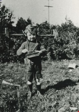
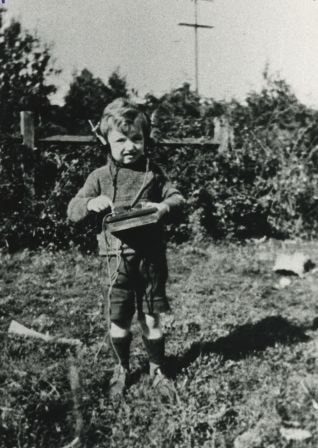
Bill Campbell with Crystal Radio Set
https://search.heritageburnaby.ca/link/archivedescription35787
- Repository
- City of Burnaby Archives
- Date
- 1923 (date of original), copied 1986
- Collection/Fonds
- Burnaby Historical Society fonds
- Description Level
- Item
- Physical Description
- 1 photograph : b&w ; 12.7 x 17.8 cm print
- Scope and Content
- Photograph of Bill Campbell with a crystal radio set built by his father, John Campbell.
- Repository
- City of Burnaby Archives
- Date
- 1923 (date of original), copied 1986
- Collection/Fonds
- Burnaby Historical Society fonds
- Subseries
- Pioneer Tales subseries
- Physical Description
- 1 photograph : b&w ; 12.7 x 17.8 cm print
- Description Level
- Item
- Record No.
- 204-645
- Access Restriction
- No restrictions
- Reproduction Restriction
- No known restrictions
- Accession Number
- BHS1988-03
- Scope and Content
- Photograph of Bill Campbell with a crystal radio set built by his father, John Campbell.
- Names
- Campbell, William "Bill"
- Media Type
- Photograph
- Notes
- Title based on contents of photograph
- Geographic Access
- Eton Street
- Street Address
- 4120 Eton Street
- Historic Neighbourhood
- Vancouver Heights (Historic Neighbourhood)
- Planning Study Area
- Burnaby Heights Area
Images
![Blasting stump, [1921 or 1922] (date of original), digitally copied 2012 thumbnail](/media/hpo/_Data/_Archives_Images/_Unrestricted/540/549-008.jpg?width=280)
Blasting stump
https://search.heritageburnaby.ca/link/archivedescription76891
- Repository
- City of Burnaby Archives
- Date
- [1921 or 1922] (date of original), digitally copied 2012
- Collection/Fonds
- Community Heritage Commission Special Projects fonds
- Description Level
- Item
- Physical Description
- 1 photograph (jpeg) : col. ; 300ppi
- Scope and Content
- Photograph of members of the Brown-John family sitting and standing on the blasting stump. This stump was located near the corner of Gilmore Avenue and Napier Street.
- Repository
- City of Burnaby Archives
- Date
- [1921 or 1922] (date of original), digitally copied 2012
- Collection/Fonds
- Community Heritage Commission Special Projects fonds
- Physical Description
- 1 photograph (jpeg) : col. ; 300ppi
- Description Level
- Item
- Record No.
- 549-008
- Access Restriction
- No restrictions
- Reproduction Restriction
- No known restrictions
- Accession Number
- 2012-30
- Scope and Content
- Photograph of members of the Brown-John family sitting and standing on the blasting stump. This stump was located near the corner of Gilmore Avenue and Napier Street.
- Subjects
- Plants - Trees
- Names
- Brown-John, Victor Joseph Charles
- Brown-John, Archie
- Brown-John, Frank
- Brown-John, Roy
- Ansdell, Elsie Brown-John
- Brown-John, Clive
- Media Type
- Photograph
- Notes
- Title based on contents of photograph
- Geographic Access
- Gilmore Avenue
- Napier Street
- Historic Neighbourhood
- Vancouver Heights (Historic Neighbourhood)
- Planning Study Area
- Willingdon Heights Area
Images
![Blasting stump, [1921 or 1922] (date of original), digitally copied 2012 thumbnail](/media/hpo/_Data/_Archives_Images/_Unrestricted/540/549-008.jpg)
![Blasting stump, [1920] (date of original), digitally copied 2012 thumbnail](/media/hpo/_Data/_Archives_Images/_Unrestricted/540/549-009.jpg?width=280)
Blasting stump
https://search.heritageburnaby.ca/link/archivedescription76892
- Repository
- City of Burnaby Archives
- Date
- [1920] (date of original), digitally copied 2012
- Collection/Fonds
- Community Heritage Commission Special Projects fonds
- Description Level
- Item
- Physical Description
- 1 photograph (jpeg) : col. ; 300ppi
- Scope and Content
- Photograph of the Brown-John children playing on the blasting stump that was located near the corner of Gilmore Avenue and Napier Street.
- Repository
- City of Burnaby Archives
- Date
- [1920] (date of original), digitally copied 2012
- Collection/Fonds
- Community Heritage Commission Special Projects fonds
- Physical Description
- 1 photograph (jpeg) : col. ; 300ppi
- Description Level
- Item
- Record No.
- 549-009
- Access Restriction
- No restrictions
- Reproduction Restriction
- No known restrictions
- Accession Number
- 2012-30
- Scope and Content
- Photograph of the Brown-John children playing on the blasting stump that was located near the corner of Gilmore Avenue and Napier Street.
- Subjects
- Plants - Trees
- Media Type
- Photograph
- Notes
- Title based on contents of photograph
- Geographic Access
- Gilmore Avenue
- Napier Street
- Historic Neighbourhood
- Vancouver Heights (Historic Neighbourhood)
- Planning Study Area
- Willingdon Heights Area
Images
![Blasting stump, [1920] (date of original), digitally copied 2012 thumbnail](/media/hpo/_Data/_Archives_Images/_Unrestricted/540/549-009.jpg)
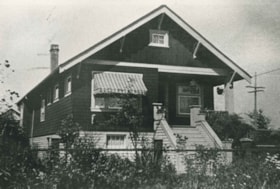
Bradbury family home
https://search.heritageburnaby.ca/link/archivedescription35377
- Repository
- City of Burnaby Archives
- Date
- 1927 (date of original), copied 1986
- Collection/Fonds
- Burnaby Historical Society fonds
- Description Level
- Item
- Physical Description
- 1 photograph : b&w ; 12.7 x 17.8 cm print
- Scope and Content
- Photograph of the Percival Bradbury family home in the 4100 block of Albert Street, North Burnaby. Percival was married to Kate Bradbury and settled in Burnaby in 1927. Later, the family moved south of Hastings Street.
- Repository
- City of Burnaby Archives
- Date
- 1927 (date of original), copied 1986
- Collection/Fonds
- Burnaby Historical Society fonds
- Subseries
- Pioneer Tales subseries
- Physical Description
- 1 photograph : b&w ; 12.7 x 17.8 cm print
- Description Level
- Item
- Record No.
- 204-234
- Access Restriction
- No restrictions
- Reproduction Restriction
- No known restrictions
- Accession Number
- BHS1988-03
- Scope and Content
- Photograph of the Percival Bradbury family home in the 4100 block of Albert Street, North Burnaby. Percival was married to Kate Bradbury and settled in Burnaby in 1927. Later, the family moved south of Hastings Street.
- Subjects
- Buildings - Residential - Houses
- Media Type
- Photograph
- Notes
- Title based on contents of photograph
- Geographic Access
- Albert Street
- Historic Neighbourhood
- Vancouver Heights (Historic Neighbourhood)
- Planning Study Area
- Burnaby Heights Area
Images


Brown Family and Home
https://search.heritageburnaby.ca/link/archivedescription35673
- Repository
- City of Burnaby Archives
- Date
- 1920 (date of original), copied 1986
- Collection/Fonds
- Burnaby Historical Society fonds
- Description Level
- Item
- Physical Description
- 1 photograph : b&w ; 12.7 x 17.8 cm print
- Scope and Content
- Photograph of the Brown family feeding chickens. From left: Alex Brown (brother, later to become MD), Janet Brown (sister), and Janet Mackintosh Macfarlane Maclean (grandmother). This photograph was taken in back of the Brown family home, 3846 Triumph, Vancouver Heights. The house was owned by t…
- Repository
- City of Burnaby Archives
- Date
- 1920 (date of original), copied 1986
- Collection/Fonds
- Burnaby Historical Society fonds
- Subseries
- Pioneer Tales subseries
- Physical Description
- 1 photograph : b&w ; 12.7 x 17.8 cm print
- Description Level
- Item
- Record No.
- 204-531
- Access Restriction
- No restrictions
- Reproduction Restriction
- No known restrictions
- Accession Number
- BHS1988-03
- Scope and Content
- Photograph of the Brown family feeding chickens. From left: Alex Brown (brother, later to become MD), Janet Brown (sister), and Janet Mackintosh Macfarlane Maclean (grandmother). This photograph was taken in back of the Brown family home, 3846 Triumph, Vancouver Heights. The house was owned by the grandmother.
- Subjects
- Animals - Poultry
- Agriculture - Farms
- Media Type
- Photograph
- Notes
- Title based on contents of photograph
- Geographic Access
- Triumph Street
- Street Address
- 3846 Triumph Street
- Historic Neighbourhood
- Vancouver Heights (Historic Neighbourhood)
- Planning Study Area
- Burnaby Heights Area
Images

![Brown-John home, [192-] (date of original), digitally copied 2012 thumbnail](/media/hpo/_Data/_Archives_Images/_Unrestricted/540/549-007.jpg?width=280)
Brown-John home
https://search.heritageburnaby.ca/link/archivedescription76890
- Repository
- City of Burnaby Archives
- Date
- [192-] (date of original), digitally copied 2012
- Collection/Fonds
- Community Heritage Commission Special Projects fonds
- Description Level
- Item
- Physical Description
- 1 photograph (jpeg) : col. ; 300ppi
- Scope and Content
- Photograph of the Brown-John home in Burnaby. Four large trucks are visible parked in front of the house.
- Repository
- City of Burnaby Archives
- Date
- [192-] (date of original), digitally copied 2012
- Collection/Fonds
- Community Heritage Commission Special Projects fonds
- Physical Description
- 1 photograph (jpeg) : col. ; 300ppi
- Description Level
- Item
- Record No.
- 549-007
- Access Restriction
- No restrictions
- Reproduction Restriction
- No known restrictions
- Accession Number
- 2012-30
- Scope and Content
- Photograph of the Brown-John home in Burnaby. Four large trucks are visible parked in front of the house.
- Media Type
- Photograph
- Notes
- Title based on contents of photograph
- Geographic Access
- Hastings Street
- Historic Neighbourhood
- Vancouver Heights (Historic Neighbourhood)
- Planning Study Area
- Willingdon Heights Area
Images
![Brown-John home, [192-] (date of original), digitally copied 2012 thumbnail](/media/hpo/_Data/_Archives_Images/_Unrestricted/540/549-007.jpg)
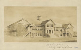
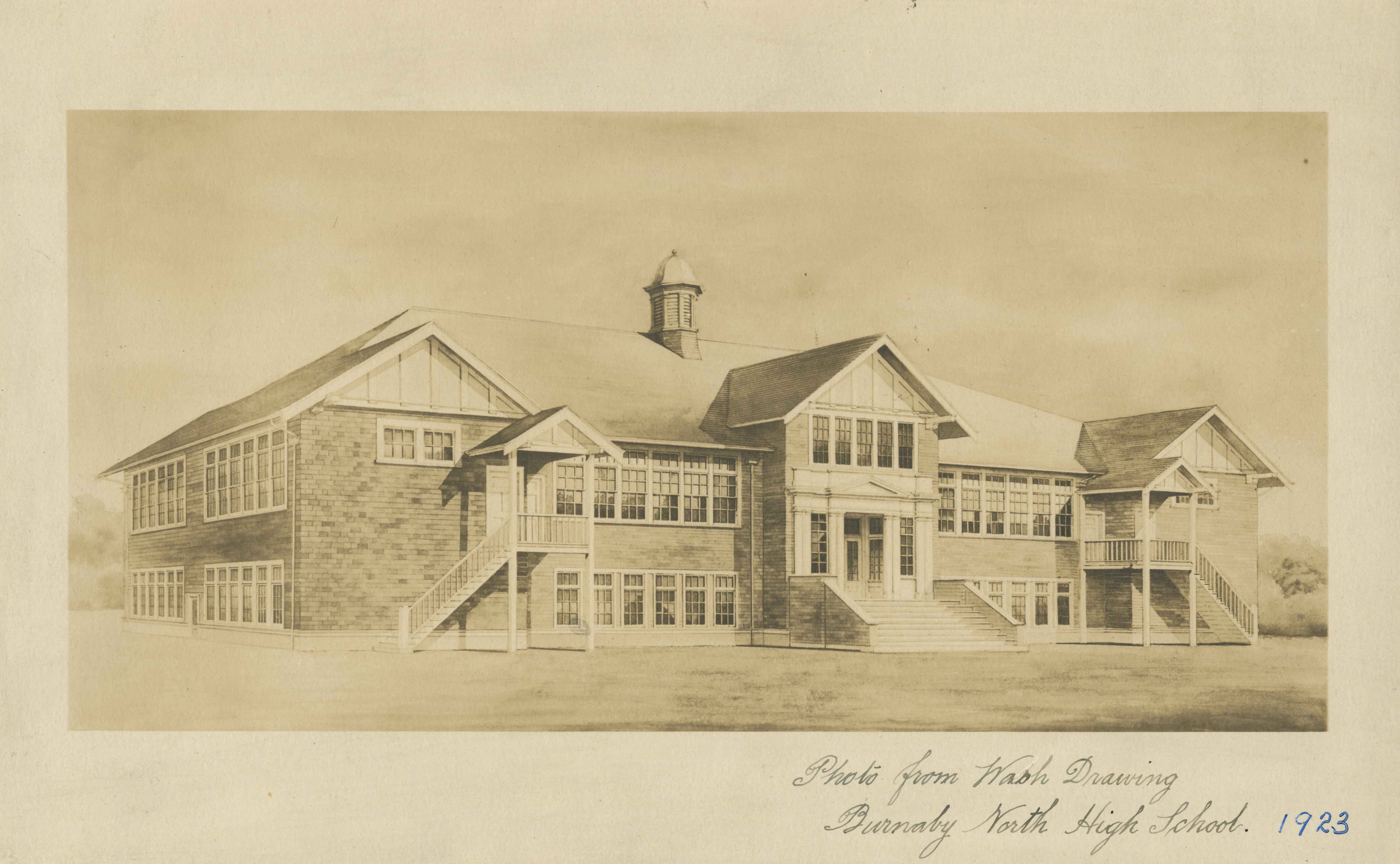
Burnaby North High School
https://search.heritageburnaby.ca/link/archivedescription34514
- Repository
- City of Burnaby Archives
- Date
- September 1923
- Collection/Fonds
- Burnaby Historical Society fonds
- Description Level
- Item
- Physical Description
- 1 photograph : b&w ; 16.0 x 25.5 cm
- Scope and Content
- Photograph of a wash drawing of the exterior of Burnaby North High School. This building later became Rosser Elementary School.
- Repository
- City of Burnaby Archives
- Date
- September 1923
- Collection/Fonds
- Burnaby Historical Society fonds
- Subseries
- Jeanie Brown subseries
- Physical Description
- 1 photograph : b&w ; 16.0 x 25.5 cm
- Description Level
- Item
- Record No.
- 033-002
- Access Restriction
- No restrictions
- Reproduction Restriction
- No known restrictions
- Accession Number
- BHS2007-04
- Scope and Content
- Photograph of a wash drawing of the exterior of Burnaby North High School. This building later became Rosser Elementary School.
- Media Type
- Photograph
- Notes
- Title based on contents of photograph
- Annotation at bottom of photograph reads, "Photo from Wash Drawing / Burnaby North High School"
- Annotation on back of photograph reads, "Compliments of the Architects Bowrman and Cullerne, September, 1923"
- Geographic Access
- Pandora Street
- Street Address
- 4375 Pandora Street
- Historic Neighbourhood
- Vancouver Heights (Historic Neighbourhood)
- Planning Study Area
- Burnaby Heights Area
Images