Narrow Results By
Subject
- Advertising Medium - Signs and Signboards 2
- Aerial Photographs 1
- Buildings - Commercial - Restaurants 1
- Buildings - Commercial - Service Stations 1
- Buildings - Industrial - Mills 1
- Buildings - Residences - Houses 1
- Buildings - Schools 1
- Documentary Artifacts - Certificates 1
- Documentary Artifacts - Postcards 2
- Education 1
- Events - May Day 2
- Events - Openings 1
Creator
- Aston, Benjamin Gwilliam 1
- Baker, Edna Dean, 1883-1956 1
- Beatty Bros Limited 1
- Betts, George Herbert, 1868-1934 1
- British Columbia Underwriters' Association 13
- Campbell Studios Limited 1
- Charlton and Rathburn 2
- Coast Map and Blue Print Co. 1
- Coe, Ida 1
- Cornish, George A. (George Augustus), 1872- 1
- De Vinne, Theodore Low, 1828-1914 1
- Dillon, Alice Christie, 1876- 1
Person / Organization
- Bailey, Lawrence "Snowball" 1
- Bailey, Wilson "Red" 1
- Barnet Mill 1
- Boscawen, Lady Margaret Florence Lucy Byng 1
- Bossort, Kathy 1
- Boy Scouts of Canada 1
- Burnaby North High School 1
- Burnaby South High School 2
- Byng, Lady Marie Evelyn Moreton 1
- Canadian National Railway 2
- Denby Brothers and Company 3
- Gilmore Avenue School 1
The City of Vancouver B.C.
https://search.heritageburnaby.ca/link/archivedescription66103
- Repository
- City of Burnaby Archives
- Date
- [between 1916 and 1929]
- Collection/Fonds
- Burnaby Historical Society fonds
- Description Level
- Item
- Physical Description
- 1 map : b&w ink on paper ; 56 x 107 cm folded to 21 x 12.5 cm
- Scope and Content
- Item is a map of "[the] City of Vancouver B.C" drawn prior to amalgamation of Point Grey and South Vancouver with the City of Vancouver.
- Repository
- City of Burnaby Archives
- Date
- [between 1916 and 1929]
- Collection/Fonds
- Burnaby Historical Society fonds
- Subseries
- Ephemera subseries
- Physical Description
- 1 map : b&w ink on paper ; 56 x 107 cm folded to 21 x 12.5 cm
- Material Details
- Map has a blue construction paper cover
- Scale : 1 inch = 1000 feet
- Description Level
- Item
- Record No.
- 42707
- Accession Number
- BHS2007-04
- Scope and Content
- Item is a map of "[the] City of Vancouver B.C" drawn prior to amalgamation of Point Grey and South Vancouver with the City of Vancouver.
- Media Type
- Cartographic Material
- Notes
- Transcribed title

Municipality of Burnaby- Volume XV and Volume XVIII
https://search.heritageburnaby.ca/link/museumdescription8686
- Repository
- Burnaby Village Museum
- Date
- May 1927
- Collection/Fonds
- Burnaby Village Museum Map collection
- Description Level
- File
- Physical Description
- 4 plans on 4 sheets : col. lithographic prints ; 63.5 x 53.5 cm folded to 53 x 31.5 cm
- Scope and Content
- File consists of four pages of plans removed from a bound book containing a series of fire insurance plans of the Municipality of Burnaby. Plan "1520" is part of "GREATER VANCOUVER B.C. / VOLUME XV / Municipality of Burnaby / May 1927" and covers District Lots: 121 and 187. Plann "1521" is part of …
- Repository
- Burnaby Village Museum
- Collection/Fonds
- Burnaby Village Museum Map collection
- Description Level
- File
- Physical Description
- 4 plans on 4 sheets : col. lithographic prints ; 63.5 x 53.5 cm folded to 53 x 31.5 cm
- Material Details
- Scale [1:600] and [1:1200]
- Scope and Content
- File consists of four pages of plans removed from a bound book containing a series of fire insurance plans of the Municipality of Burnaby. Plan "1520" is part of "GREATER VANCOUVER B.C. / VOLUME XV / Municipality of Burnaby / May 1927" and covers District Lots: 121 and 187. Plann "1521" is part of "GREATER VANCOUVER B.C. / VOLUME XV / Municipality of Burnaby / May 1927" and covers District Lots: 121 and 187. Key plan "H" reads: "GREATER VANCOUVER B.C. / VOLUME XVIII / Surveyed _ May 1927 / MUNICIPALITY OF / BURNABY" and covers plans: 1813 to 1822; 1824 to 1832; 1839; 1840; 1853 to 1865 and District Lots: 28; 30; 53; 90 to 93; 95 to 97; 155a; 155b; 155c; 159; 160; 171 to 173. Plan "1801" is part of "GREATER VANCOUVER B.C. / VOLUME XVIII / Municipality of Burnaby / May 1927" and covers District Lot 153.
- Responsibility
- British Columbia Underwriters' Association
- Accession Code
- HV972.111.8
- Access Restriction
- No restrictions
- Reproduction Restriction
- May be restricted by third party rights
- Date
- May 1927
- Media Type
- Cartographic Material
- Historic Neighbourhood
- Fraser Arm (Historic Neighbourhood)
- Vancouver Heights (Historic Neighbourhood)
- East Burnaby (Historic Neighbourhood)
- Edmonds (Historic Neighbourhood)
- Planning Study Area
- Marlborough Area
- Kingsway-Beresford Area
- Windsor Area
- Big Bend Area
- Clinton-Glenwood Area
- Burnaby Heights Area
- Edmonds Area
- Stride Avenue Area
- Scan Resolution
- 400
- Scan Date
- 2021-11-18
- Notes
- Title based on content of plans
- See also BV987.1.70d for revised versions of plans
- Scale is measured 1 inch = 500 feet
Zoomable Images


Municipality of Burnaby - Volume XVI and Volume XVII
https://search.heritageburnaby.ca/link/museumdescription8684
- Repository
- Burnaby Village Museum
- Date
- May 1927
- Collection/Fonds
- Burnaby Village Museum Map collection
- Description Level
- File
- Physical Description
- 4 plans on 4 sheets : col. lithographic prints ; 63.5 x 53.5 cm folded to 53 x 31.5 cm
- Scope and Content
- File consists of four pages of plans removed from a bound book containing a series of fire insurance plans of the Municipality of Burnaby. Page "D" is titled: "GREATER VANCOUVER B.C. / VOLUME XVI / Surveyed _ May 1927 / MUNICIPALITY OF / BURNABY / PLAN DEPT. FIRE BRANCH _ B.C. INSURANCE UNDERWRITE…
- Repository
- Burnaby Village Museum
- Collection/Fonds
- Burnaby Village Museum Map collection
- Description Level
- File
- Physical Description
- 4 plans on 4 sheets : col. lithographic prints ; 63.5 x 53.5 cm folded to 53 x 31.5 cm
- Material Details
- Scale [1:1200] and [1:6000]
- Scope and Content
- File consists of four pages of plans removed from a bound book containing a series of fire insurance plans of the Municipality of Burnaby. Page "D" is titled: "GREATER VANCOUVER B.C. / VOLUME XVI / Surveyed _ May 1927 / MUNICIPALITY OF / BURNABY / PLAN DEPT. FIRE BRANCH _ B.C. INSURANCE UNDERWRITERS ASSN." / KEY PLAN". Plans covered in this "Key Plan" are numbered 1601 to 1626, 1632 and 1651 covering District Lots: 15; 31; 100 to 102; 114; 141 to 144; 147 and 148; 209 to 214. Plan "E" is part of "GREATER VANCOUVER B.C. / VOLUME XVII / Municipality of Burnaby / May 1927" and covers plans: 1701 to 1705; 1711 to 1715; 1723 to 1727; 1729 to 1733; 1737 to 1742 and District Lots: 68 to 74; 80 to 84; 32 to 35 and 38 to 39. Plan marked "F" is a key plan titled: "GREATER VANCOUVER B.C. / VOLUME XVII / Surveyed _ May 1927 / MUNICIPALITY OF / BURNABY and covers plans: 1706 to 1710; 1716 to 1722; 1734 and 1735; 1743 to 1752 and District Lots: 42 to 44; 59; 75 to 80; 83 to 87; 89 to 93 and 130. Plan "1729" is part of "GREATER VANCOUVER B.C. / VOLUME XVII / Municipality of Burnaby / May 1927" and covers District Lots 34 and 35.
- Responsibility
- British Columbia Underwriters' Association
- Accession Code
- HV972.111.6
- Access Restriction
- No restrictions
- Reproduction Restriction
- May be restricted by third party rights
- Date
- May 1927
- Media Type
- Cartographic Material
- Historic Neighbourhood
- Barnet (Historic Neighbourhood)
- Burquitlam (Historic Neighbourhood)
- Central Park (Historic Neighbourhood)
- Burnaby Lake (Historic Neighbourhood)
- Broadview (Historic Neighbourhood)
- Planning Study Area
- Burnaby Mountain Area
- Lyndhurst Area
- Lake City Area
- Cascade-Schou Area
- Garden Village Area
- Douglas-Gilpin Area
- Oakalla Area
- Scan Resolution
- 400
- Scan Date
- 2021-11-18
- Notes
- Title based on content of plans
- See also BV987.1.70d for revised versions of plans
- Scale is measured 1 inch = 500 feet
Zoomable Images


Municipality of Burnaby - Volume XV, Volume XVI, Volume XVII, Volume XVIII
https://search.heritageburnaby.ca/link/museumdescription8685
- Repository
- Burnaby Village Museum
- Date
- May 1927
- Collection/Fonds
- Burnaby Village Museum Map collection
- Description Level
- File
- Physical Description
- 4 plans on 4 sheets : col. lithographic prints ; 63.5 x 53.5 cm folded to 53 x 31.5 cm
- Scope and Content
- File consists of four pages of plans removed from a bound book containing a series of fire insurance plans of the Municipality of Burnaby. Plan "1531" is part of "GREATER VANCOUVER B.C. / VOLUME XV / Municipality of Burnaby / May 1927" and covers District Lots: 116 and 117. Key Plan "C" is part of …
- Repository
- Burnaby Village Museum
- Collection/Fonds
- Burnaby Village Museum Map collection
- Description Level
- File
- Physical Description
- 4 plans on 4 sheets : col. lithographic prints ; 63.5 x 53.5 cm folded to 53 x 31.5 cm
- Material Details
- Scale [1:600] and [1:1200]
- Scope and Content
- File consists of four pages of plans removed from a bound book containing a series of fire insurance plans of the Municipality of Burnaby. Plan "1531" is part of "GREATER VANCOUVER B.C. / VOLUME XV / Municipality of Burnaby / May 1927" and covers District Lots: 116 and 117. Key Plan "C" is part of "GREATER VANCOUVER B.C. / VOLUME XVI / Municipality of Burnaby / May 1927" and covers plans 1623 to 1651 and District Lots: 1 and 2; 4; 6; 8; 10 to 14; 25; 27; 40; 56 to 58; 88 and 89. Plan "1738" is part of "GREATER VANCOUVER B.C. / VOLUME XVII / Municipality of Burnaby / May 1927" and covers District Lots: 34 and 35. Key plan "G" is part of "GREATER VANCOUVER B.C. / VOLUME XVIII / Municipality of Burnaby / May 1927" and covers plans: 1801 to 1813; 1823; 1824; 1833 to 1838; 1841 to 1853 and District Lots: 32; 93; 94; 97 to 99; 149; 150; 152; 155 to 159; 161 to 164.
- Responsibility
- British Columbia Underwriters' Association
- Accession Code
- HV972.111.7
- Access Restriction
- No restrictions
- Reproduction Restriction
- May be restricted by third party rights
- Date
- May 1927
- Media Type
- Cartographic Material
- Historic Neighbourhood
- Central Park (Historic Neighbourhood)
- Fraser Arm (Historic Neighbourhood)
- Alta Vista (Historic Neighbourhood)
- Broadview (Historic Neighbourhood)
- Vancouver Heights (Historic Neighbourhood)
- Burquitlam (Historic Neighbourhood)
- East Burnaby (Historic Neighbourhood)
- Edmonds (Historic Neighbourhood)
- Lozells (Historic Neighbourhood)
- Planning Study Area
- Clinton-Glenwood Area
- Marlborough Area
- Maywood Area
- Windsor Area
- Big Bend Area
- Garden Village Area
- Willingdon Heights Area
- West Central Valley Area
- Cariboo-Armstrong Area
- Lyndhurst Area
- Cameron Area
- Lake City Area
- Edmonds Area
- Second Street Area
- Sperling-Broadway Area
- Lakeview-Mayfield Area
- Scan Resolution
- 400
- Scan Date
- 2021-11-18
- Notes
- Title based on content of plans
- See also BV987.1.70d for revised versions of plans
- Scale is measured 1 inch = 500 feet
Zoomable Images

Municipality of Burnaby - Volume XV, Volume XVI, Volume XVII, Volume XVIII, May 1927
Zoom into Image

Municipality of Burnaby - Volume XV and Volume XVIII
https://search.heritageburnaby.ca/link/museumdescription8680
- Repository
- Burnaby Village Museum
- Date
- May 1927
- Collection/Fonds
- Burnaby Village Museum Map collection
- Description Level
- File
- Physical Description
- 4 plans on 4 sheets : col. lithographic prints ; 63.5 x 53.5 cm folded to 53 x 31.5 cm
- Scope and Content
- File consists of four pages of plans removed from a bound book containing a series of fire insurance plans of the Municipality of Burnaby. The first two pages are numbered "A" and "B" and are key plans from "GREATER VANCOUVER B.C. / VOLUME XV / Surveyed _ May 1927 / MUNICIPALITY OF / BURNABY", "PLA…
- Repository
- Burnaby Village Museum
- Collection/Fonds
- Burnaby Village Museum Map collection
- Description Level
- File
- Physical Description
- 4 plans on 4 sheets : col. lithographic prints ; 63.5 x 53.5 cm folded to 53 x 31.5 cm
- Material Details
- Scales [1:1200] and [1:6000]
- Scope and Content
- File consists of four pages of plans removed from a bound book containing a series of fire insurance plans of the Municipality of Burnaby. The first two pages are numbered "A" and "B" and are key plans from "GREATER VANCOUVER B.C. / VOLUME XV / Surveyed _ May 1927 / MUNICIPALITY OF / BURNABY", "PLAN DEPT. FIRE BRANCH _ B.C. INSURANCE UNDERWRITERS ASSN.". Key Plan "B" covers plans: 1505; 1506; 1512 to 1516; 1540 to 1544; 1550 to 1557 and District Lots: 129 to 132; 135 to 138; 205 to 208 and 215 to 218. Key Plan "A" covers plans: 1501 to 1504; 1507 to 1511; 1517 to 1525; 1531 to 1539; 1545 to 1550 and District Lots: 116 to 127 and 186 to 189. Plan "1806" is part of "GREATER VANCOUVER B.C. / VOLUME XVIII / Municipality of Burnaby / May, 1927" and covers District Lot 153. Plan "1807" is from "GREATER VANCOUVER B.C. / VOLUME XVIII / Municipality of Burnaby / May, 1927" and covers District Lots: 99,149 and 152.
- Responsibility
- British Columbia Underwriters' Association
- Accession Code
- HV972.111.2
- Access Restriction
- No restrictions
- Reproduction Restriction
- May be restricted by third party rights
- Date
- May 1927
- Media Type
- Cartographic Material
- Historic Neighbourhood
- Vancouver Heights (Historic Neighbourhood)
- Lochdale (Historic Neighbourhood)
- Capitol Hill (Historic Neighbourhood)
- Central Park (Historic Neighbourhood)
- Alta Vista (Historic Neighbourhood)
- Planning Study Area
- Burnaby Heights Area
- Sperling-Broadway Area
- Lochdale Area
- Parkcrest-Aubrey Area
- Westridge Area
- Willingdon Heights Area
- Capitol Hill Area
- Maywood Area
- Marlborough Area
- Scan Resolution
- 400
- Scan Date
- 2021-11-18
- Notes
- Title based on content of plans
- Scales are measured 1 inch = 100 feet and 1 inch = 500 feet
- See also BV987.1.70d for revised versions of plans
Zoomable Images


The voice of Canada : a selection of prose and verse
https://search.heritageburnaby.ca/link/museumlibrary183
- Repository
- Burnaby Village Museum
- Collection
- Special Collection
- Material Type
- Book
- Accession Code
- HV971.120.31
- Call Number
- 810.8 STE Copy 1
- Place of Publication
- London
- Toronto
- Publisher
- J. M. Dent & Sons Limited
- Publication Date
- 1926
- Physical Description
- xiii, 144 p. : ill. ; 18 cm.
- Inscription
- Front endpaper: "W15" [written and crossed out in black ink] "Peggy McKay" "409-15 Ave East" "Vancouver B.C." [written in blue ink] "Gertrude Gleave" "52B - __ Ave E." "Vancouver" "B.C." [written and crossed out in blue ink] "I wish I were ____ of bro- And you a l- health Some _____ ma- passing by Would bind us b- together Ame-" [written in black ink, endpaper is torn cutting off words] Front fly leaf: "I'm dreaming of that nite of love with you in ____ I thrilled with delight alone time that nite with you. Graby etc." [written in black ink] Drawing of a woman's face in pencil and black ink. "Ho Ho." "drawn by Lena Cade" [written in pencil] page iv: poem written in black ink. page 130: drawing of a woman's face in pencil and black ink. Back flyleaf: drawing of a woman's face in pencil. "Florence Nightingale Show" "St. Peter's Church "French Gramar" "English Girl Society" "Vancouver B.C. "Gertrude E.R.L Gleave" "G G.E.R.L.G" [written in pencil] Back endpaper: "Do not with to have money. for sad are the wealthy ones." [written in black ink]
- Library Subject (LOC)
- Canadian literature
- Poetry
- Notes
- Includes bibliography
- selected by A.M. Stephen
- Illustrated by E. Wallcousins
- Copy 1 of 3
Arithmetic book I
https://search.heritageburnaby.ca/link/museumlibrary166
- Repository
- Burnaby Village Museum
- Author
- Smith, J. A.
- Roberts, R. H.
- Publication Date
- 1922
- Call Number
- 510.76 SMI 1922 Ver. 1
- Repository
- Burnaby Village Museum
- Collection
- Special Collection
- Material Type
- Book
- Accession Code
- HV971.120.13
- Call Number
- 510.76 SMI 1922 Ver. 1
- Author
- Smith, J. A.
- Roberts, R. H.
- Place of Publication
- Toronto, Ont.
- Publisher
- W. J. Gage & Company, Limited
- Publication Date
- 1922
- Series
- Gage's Educational Series
- Physical Description
- vi, 278 p. : ill. ; 19 cm.
- Inscription
- "Free Text-book...By order of the education department of B.C." -- Stickered on endpaper (front). "Margaret McKay / Mount Pleasant School / 6B" -- handwritten in pen on sticker. "Margaret McKay" -- handwritten and crossed-out in pen on flyleaf. "2543 Main St. Vancouver, B.C." -- handwritten in pencil on flyleaf. "Margaret McKay / 2543 Main St. / mt. Pleasant School / Vancouver, B.C" -- handwritten in pen on flyleaf. "Peggy McKay / 742 Broadway East / Mount Pleasant School" -- handwritten in pencil on endpaper (front). Various handwrittings -- crossed-out in coloured pencil.
- Library Subject (LOC)
- Arithmetic--Study and teaching
- Notes
- "Authorized in separate editions for use in British Columbia, Alberta, Manitoba, and Nova Scotia." -- title page.
- Version 1 of 3
- Includes index.
The Canadian school atlas : containing seventy-three maps with complete index
https://search.heritageburnaby.ca/link/museumlibrary189
- Repository
- Burnaby Village Museum
- Edition
- Rev. and enl. ed.
- Publication Date
- 1925
- Call Number
- 912 COR
- Repository
- Burnaby Village Museum
- Collection
- Special Collection
- Material Type
- Book
- Accession Code
- HV971.120.25
- Call Number
- 912 COR
- Edition
- Rev. and enl. ed.
- Contributor
- Cornish, George A. (George Augustus), 1872-
- Place of Publication
- Toronto
- Publisher
- J. M. Dent & Sons, Ltd.
- Publication Date
- 1925
- Printer
- The Temple Press
- Physical Description
- 1 v. (multiple pagings) : col. ill. (maps) : 29 cm.
- Inscription
- "This Book Cover is presented with the / compliments of / The Royal Bank of Canada", printed on front of jacket. Atlas / Peggy McKay / Florence Nightingale School / Vancouver BC" hand written on front of dust jacket. "Peggy McKay" [Handwritten in black ink on outside envelope] "Billy McKay 409-15th Av. East Vancouver B.C. Canada" [Handwritten in pencil on front endpaper] "Jack McLennan" [Handwritten in pencil on front endpaper] "Oh dear Baby face Drawn by Peggy McKay" [Handwritten in pencil around drawing of a woman's face on front endpaper] "Peggy McKay Florence Nightingale Vancouver B.C. Canada" [Handwritten in blue ink on front flyleaf] "Along came you, sweet little you, Just like a flower you came. You came into my heart never to leave me + never to part." [Handwritten in pencil on title page] "Liar" [Handwritten in pencil on title page] "867-5309" [Handwritten in pencil on contents verso] "Jenny's number... 867-5309, 867-5309 I got it, I got it, I got you number on the wa-ll I got, I got it, for a good time for a good time CALL" [Handwritten on contents verso] Handwritten story from front flyleaf to pre-title page verso (4 pages) Drawing of woman's face on front flyleaf. Song lyrics handwritten in blue ink on title page verso and opposite contents. List of names under the index, page 32.
- Library Subject (LOC)
- Atlases--Canadian
- Historical geography--Maps
- Canada--History--Study and teaching
- Atlases
- Notes
- Includes index.
- "Under the editorship of George A. Cornish" -- Pre Title-Page Verso
- "Prepared at the Edinburgh Geographical Institute to form a companion to the 'Canadian School Geography'" -- Pre Title-Page Verso
- "Authorized for use in the schools of the provinces of Nova Scotia, Quebec, Saskatchewan and British Columbia" -- Cover
- Contributor's full name and date as follows:George A Cornish (George Augustus), 1872-1960
Digest of elementary chemistry : regents - college entrance
https://search.heritageburnaby.ca/link/museumlibrary7325
- Repository
- Burnaby Village Museum
- Collection
- Special Collection
- Material Type
- Book
- Accession Code
- BV018.25.2
- Call Number
- 540 MEN
- Author
- Mendel, Martin
- Place of Publication
- New York
- Publisher
- Globe Book company
- Publication Date
- c1927
- Physical Description
- v, 234 p. : ill ; 19 cm.
- Inscription
- Top left corner of front end paper "J.G. Acres. 1775 Marine Dr. W. Vancouver B.C." [handwritten in black pen with each line crossed out ] Middle of title page "Jack Acres. Class 6 Magee High School Vancouver, B.C." "Hugh Young. Room 21. Magee High" [ Two different handwritten notes with the "Jack" section crossed out only. In black... maybe dark blue pen?]
- Library Subject (LOC)
- Chemistry
- Object History
- Textbook used at Gilmore School. Came via donor's parents who were teachers at the school: William (Bill) McKenzie and Georgina McKenzie.
- Notes
- "Head of the Chemistry Department, Thomas Jefferson High School, Broooklyn, New York."
Gillis family fonds
https://search.heritageburnaby.ca/link/archivedescription66689
- Repository
- City of Burnaby Archives
- Date
- 1914-1940 (date of originals), copied 2011
- Collection/Fonds
- Gillis family fonds
- Description Level
- Fonds
- Physical Description
- 4 photographs (jpeg)
- Scope and Content
- Fonds consists of scanned photographs of the members of the Gillis family.
- Repository
- City of Burnaby Archives
- Date
- 1914-1940 (date of originals), copied 2011
- Collection/Fonds
- Gillis family fonds
- Physical Description
- 4 photographs (jpeg)
- Material Details
- Records exist only in electronic format
- Description Level
- Fonds
- Access Restriction
- No restrictions
- Accession Number
- 2011-10
- Scope and Content
- Fonds consists of scanned photographs of the members of the Gillis family.
- History
- Duncan Gillis was born on March 25, 1892, in Vancouver, B.C., to James Gillis and Isabelle (Adams) Gillis. He had four older siblings: Isabel, Allan, James, and Marion. Duncan died on April 2, 1985, in Kamloops, B.C. James and Isabelle were from New Brunswick and lived in Minnesota for a time, which is where the three oldest children were born, and then came to British Columbia and pioneered in Yennadon (Maple Ridge) in 1890. Florence Ethel Denton was born on December 9, 1894, in Vancouver, B.C. to Edwin Denton and Elizabeth Anne (Zinn) Denton. She had three siblings: John, Edwin, and Beatrice. Florence died on February 28, 1962, in Kamloops, B.C. Edwin Denton was born in England and met Elizabeth in Ohio were she was born. They were married in 1890 in Vancouver. Florence’s older brother, John Montague Denton, was born on August 7, 1892. He enlisted on October 6, 1915, as part of the Canadian Infantry (British Columbia Regiment) 72nd Batalion and was killed in France on November 1, 1916, at the age of 24. He is buried in St. Sever Cemetery, Rouen, France. Duncan married Florence on June 27, 1914, in Eburne, B.C. Florence was the first schoolteacher at the newly built school in Yennadon (Maple Ridge), which was built by Duncan’s father James in 1913. This is how they met. Duncan was working as a carpenter and saw filer before enlisting on January 8, 1916, at the age of 23. He served overseas and was captured as a prisoner of war (POW) for a time. When Duncan returned to Canada, he and Florence had three sons: Boyd Leslie “Bud” born on January 7, 1920; Norman Montague born on August 20, 1921; and Donald Allan Gillis born on February 23, 1923. They raised their family in Burnaby, B.C., and lived there until 1960, then moving to Kamloops, B.C. Bud served overseas as a Flying Officer (Wireless Gunner) during World War II for the 428 (RCAF) Squadron. He was on his fifteenth operation and took part in the raid on Aachem on the night of July 13 (14), 1943, when the plane was shot down over Holland. It was later determined that he had been captured as a POW at Stalag 6 and wasn’t released until May 14, 1945, returning home in August of 1945. He married Mary Irene Thoen and had five children: James, Steven, Donna, Gregory, and Pamela. Boyd was also a carpenter and saw filer and had a saw shop in Kamloops where he raised his family. He also enjoyed woodworking in his spare time and built three airplanes. Boyd died in 1979 in Edmonton, Alberta. Norman Montague served overseas as a Flight Engineer Sergeant during World War II for the 138 RCAF Squadron. His plane crashed in the woods while attempting to land at RAF Woodridge, England, returning from an operational flight. He was pronounced dead on admission to hospital, December 17, 1943, at the age of 22. He is buried in Rushden Cemetery, Northamptonshire, England. Donald served in the Royal Canadian Naval Reserve during World War II. He enlisted on May 9, 1942, and was a Signalman on a Corvette in the Atlantic. In 1944, after hearing of the loss of his two older brothers, the RCNR moved him to the Pacific, where he was until November 9, 1945. He married May Yule Ferrier and had two children, Robert and Barbara. Donald graduated from the University of British Columbia in 1951 with a Bachelor's of Science in Civil Engineering. He worked for the City of Burnaby for five years and for the Greater Vancouver Regional District for 32 years, while living in Burnaby, B.C. and raising his family. He retired to the Sunshine Coast, Halfmoon Bay, B.C. in 1988, where he still lives today.
- Media Type
- Photograph
- Creator
- Gillis family
- Notes
- Title based on contents of fonds
- Photo catalogue 524
![Gilmore Avenue School, [192-] thumbnail](/media/hpo/_Data/_BVM_Images/1985/1985_0100_0004_001.jpg?width=280)
Gilmore Avenue School
https://search.heritageburnaby.ca/link/museumdescription2992
- Repository
- Burnaby Village Museum
- Date
- [192-]
- Collection/Fonds
- Burnaby Village Museum Photograph collection
- Description Level
- Item
- Physical Description
- 1 photograph : b&w postcard ; 8.9 x 13.9 cm
- Scope and Content
- Photograph of the front of the Gilmore Avenue School. Note the doors and stairways added on to the side of the building, and the electric power pole and the power lines in front of the school building. Inscribed in the original negative and printed on the bottom front right of the photograph: "Gil…
- Repository
- Burnaby Village Museum
- Collection/Fonds
- Burnaby Village Museum Photograph collection
- Description Level
- Item
- Physical Description
- 1 photograph : b&w postcard ; 8.9 x 13.9 cm
- Scope and Content
- Photograph of the front of the Gilmore Avenue School. Note the doors and stairways added on to the side of the building, and the electric power pole and the power lines in front of the school building. Inscribed in the original negative and printed on the bottom front right of the photograph: "Gilmore Ave. School / Van. Heights. / Vancouver, B.C." Printed on the bottom front left of the postcard: "J.M. Henton. Photographer, Vancouver, B.C."
- Subjects
- Buildings - Schools
- Geographic Access
- Gilmore Avenue
- Street Address
- 50 Gilmore Avenue
- Accession Code
- BV985.100.4
- Access Restriction
- No restrictions
- Reproduction Restriction
- No known restrictions
- Date
- [192-]
- Media Type
- Photograph
- Historic Neighbourhood
- Vancouver Heights (Historic Neighbourhood)
- Planning Study Area
- Burnaby Heights Area
- Related Material
- For another postcard of the same image, see HV983.70.2 stored with the postcards.
- Scan Resolution
- 600
- Scan Date
- 2024-02-02
- Photographer
- Henton, John Morse
- Notes
- Title based on contents of photograph
Images
![Gilmore Avenue School, [192-] thumbnail](/media/hpo/_Data/_BVM_Images/1985/1985_0100_0004_001.jpg)
Girl Guides at Queen's Park
https://search.heritageburnaby.ca/link/museumdescription4904
- Repository
- Burnaby Village Museum
- Date
- 1923
- Collection/Fonds
- Burnaby Girl Guides fonds
- Description Level
- Item
- Physical Description
- 1 photograph : sepia ; 21.5 x 25.5 cm
- Scope and Content
- Photograph of a large group of Girl Guides dressed in uniform gathered together for a group photograph on the field at Queen's Park, New Westminster. The photograph appears to have been taken from above.
- Repository
- Burnaby Village Museum
- Collection/Fonds
- Burnaby Girl Guides fonds
- Description Level
- Item
- Physical Description
- 1 photograph : sepia ; 21.5 x 25.5 cm
- Scope and Content
- Photograph of a large group of Girl Guides dressed in uniform gathered together for a group photograph on the field at Queen's Park, New Westminster. The photograph appears to have been taken from above.
- Names
- Girl Guides of Canada
- Geographic Access
- New Westminster
- Accession Code
- BV015.35.262
- Access Restriction
- No restrictions
- Reproduction Restriction
- No known restrictions
- Date
- 1923
- Media Type
- Photograph
- Scan Resolution
- 600
- Scan Date
- January 6, 2021
- Scale
- 100
- Photographer
- Frank, Leonard
- Notes
- Title based on contents of photograph
- Embossment in lower right corner of photograph reads: "Leonard Frank / Vancouver, B.C."
- Oval stamp on verso of photograph reads: "Leonard Frank / Photographic Artist / 533 Granville St. / Sey. 1029 Vancouver, B.C."
- Note in ink on verso of photograph reads: "West_1923"
- Note in black grease pencil on verso of photograph reads:"No 3477"
- Photograph is a part of scrapbook "Burnaby Girl Guides. -- [1914]-1969, predominant ca. 1920" (BV.015.35.164)
Images

Municipality of Burnaby - Volume XV and Volume XVIII
https://search.heritageburnaby.ca/link/museumdescription8681
- Repository
- Burnaby Village Museum
- Date
- May 1927
- Collection/Fonds
- Burnaby Village Museum Map collection
- Description Level
- File
- Physical Description
- 4 plans on 4 sheets : col. lithographic prints, ms. annotations in blue ink ; 63.5 x 53.5 cm folded to 53 x 31.5 cm
- Scope and Content
- File consists of four pages of plans removed from a bound book containing a series of fire insurance plans of the Municipality of Burnaby. Plan "1507" and plan "1517" are from "GREATER VANCOUVER B.C. / VOLUME XV / Municipality of Burnaby / May, 1927". Plan "1507" covers District Lot 186 and plan "1…
- Repository
- Burnaby Village Museum
- Collection/Fonds
- Burnaby Village Museum Map collection
- Description Level
- File
- Physical Description
- 4 plans on 4 sheets : col. lithographic prints, ms. annotations in blue ink ; 63.5 x 53.5 cm folded to 53 x 31.5 cm
- Material Details
- Scale [1:600] and [1:1200]
- Scope and Content
- File consists of four pages of plans removed from a bound book containing a series of fire insurance plans of the Municipality of Burnaby. Plan "1507" and plan "1517" are from "GREATER VANCOUVER B.C. / VOLUME XV / Municipality of Burnaby / May, 1927". Plan "1507" covers District Lot 186 and plan "1517" covers District Lot 116. Plan "1804" and plan "1805" are from "GREATER VANCOUVER B.C. / VOLUME XVIII / Municipality of Burnaby / May, 1927". Plans "1804" and "1805" cover District Lot 153.
- Responsibility
- British Columbia Underwriters' Association
- Accession Code
- HV972.111.3
- Access Restriction
- No restrictions
- Reproduction Restriction
- May be restricted by third party rights
- Date
- May 1927
- Media Type
- Cartographic Material
- Historic Neighbourhood
- Central Park (Historic Neighbourhood)
- Vancouver Heights (Historic Neighbourhood)
- Planning Study Area
- Maywood Area
- Willingdon Heights Area
- Scan Resolution
- 400
- Scan Date
- 2021-11-18
- Notes
- Title based on content of plans
- See also BV987.1.70d for revised versions of plans
- Scale is measured 1 inch = 100 feet
Images


![Municipality of Burnaby - Volume XV and Volume XVIII, 1927-[1940] thumbnail](/media/hpo/_Data/_BVM_Artifacts/1972/1972_0111_0004_003.jpg?width=280)
Municipality of Burnaby - Volume XV and Volume XVIII
https://search.heritageburnaby.ca/link/museumdescription8682
- Repository
- Burnaby Village Museum
- Date
- 1927-[1940]
- Collection/Fonds
- Burnaby Village Museum Map collection
- Description Level
- File
- Physical Description
- 4 plans on 4 sheets: col. lithographic prints ; 63.5 x 53.5 cm folded to 53 x 31.5 cm
- Scope and Content
- File consists of four pages of plans removed from a bound book containing a series of fire insurance plans of the Municipality of Burnaby. Plan "1518" and "1519" are from "GREATER VANCOUVER B.C. / VOLUME XV / Municipality of Burnaby / May, 1927". Plan "1518" covers District Lot 116 and Plan "1519"…
- Repository
- Burnaby Village Museum
- Collection/Fonds
- Burnaby Village Museum Map collection
- Description Level
- File
- Physical Description
- 4 plans on 4 sheets: col. lithographic prints ; 63.5 x 53.5 cm folded to 53 x 31.5 cm
- Material Details
- Scale [1:600]
- Scope and Content
- File consists of four pages of plans removed from a bound book containing a series of fire insurance plans of the Municipality of Burnaby. Plan "1518" and "1519" are from "GREATER VANCOUVER B.C. / VOLUME XV / Municipality of Burnaby / May, 1927". Plan "1518" covers District Lot 116 and Plan "1519" covers District Lot 121. Plan "1802" and plan "1803" are from "GREATER VANCOUVER B.C. / VOLUME XVIII / Municipality of Burnaby / May, 1927". Both plans "1802" and "1803" cover District Lot 153.
- Responsibility
- British Columbia Underwriters' Association
- Accession Code
- HV972.111.4
- Access Restriction
- No restrictions
- Reproduction Restriction
- May be restricted by third party rights
- Date
- 1927-[1940]
- Media Type
- Cartographic Material
- Historic Neighbourhood
- Vancouver Heights (Historic Neighbourhood)
- Central Park (Historic Neighbourhood)
- Planning Study Area
- Willingdon Heights Area
- Marlborough Area
- Scan Resolution
- 400
- Scan Date
- 2021-11-18
- Notes
- Title based on content of plans
- See also BV987.1.70d for revised versions of plans
- Scale is measured 1 inch = 50 feet
- Contact Burnaby Village Museum to access plans 1518 and 1519 (these plans have revisions on top - date of revisions is uncertain)
Images
![Municipality of Burnaby - Volume XV and Volume XVIII, 1927-[1940] thumbnail](/media/hpo/_Data/_BVM_Artifacts/1972/1972_0111_0004_003.jpg)


Municipality of Burnaby - Volume XVIII and Volume XIX
https://search.heritageburnaby.ca/link/museumdescription8683
- Repository
- Burnaby Village Museum
- Date
- May 1927
- Collection/Fonds
- Burnaby Village Museum Map collection
- Description Level
- File
- Physical Description
- 2 plans on 2 sheets : col. lithographic prints ; 63.5 x 53.5 cm folded to 53 x 31.5 cm
- Scope and Content
- File consists of two pages of plans removed from a bound book containing a series of fire insurance plans of the Municipality of Burnaby. Plan "1832" is from "GREATER VANCOUVER B.C. / VOLUME XVIII / Municipality of Burnaby / May, 1927" and covers District Lots: 98 and 28. Plan "K" is part of a key …
- Repository
- Burnaby Village Museum
- Collection/Fonds
- Burnaby Village Museum Map collection
- Description Level
- File
- Physical Description
- 2 plans on 2 sheets : col. lithographic prints ; 63.5 x 53.5 cm folded to 53 x 31.5 cm
- Material Details
- Scale [1:1200] to [1:6000]
- Scope and Content
- File consists of two pages of plans removed from a bound book containing a series of fire insurance plans of the Municipality of Burnaby. Plan "1832" is from "GREATER VANCOUVER B.C. / VOLUME XVIII / Municipality of Burnaby / May, 1927" and covers District Lots: 98 and 28. Plan "K" is part of a key plan "GREATER VANCOUVER B.C. / Surveyed VOLUME XIX May 1927 / MUNICIPALITY OF / BURNABY / PLAN DEPT. British Columbia Ins. Underwriters Association / FIRE BRANCH / KEY PLAN", "Scale 500 FT = 1 INCH / FOR REPORT SEE VOL. XV" covering plans: 1901 to 1914 and District Lots: 161; 164 to 167; 155c; 155; 172 and 173.
- Responsibility
- British Columbia Underwriters' Association
- Accession Code
- HV972.111.5
- Access Restriction
- No restrictions
- Reproduction Restriction
- May be restricted by third party rights
- Date
- May 1927
- Media Type
- Cartographic Material
- Historic Neighbourhood
- East Burnaby (Historic Neighbourhood)
- Central Park (Historic Neighbourhood)
- Fraser Arm (Historic Neighbourhood)
- Alta Vista (Historic Neighbourhood)
- Planning Study Area
- Windsor Area
- Marlborough Area
- Second Street Area
- Big Bend Area
- Sussex-Nelson Area
- Scan Resolution
- 400
- Scan Date
- 2021-11-18
- Notes
- Title based on content of plans
- See also BV987.1.70d for revised versions of plans
- Scale is measured 1 inch = 500 feet
Zoomable Images

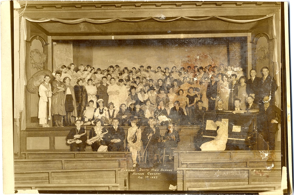
South Burnaby High School Annual concert
https://search.heritageburnaby.ca/link/museumdescription3881
- Repository
- Burnaby Village Museum
- Date
- 7 Feb. 1927
- Collection/Fonds
- Burnaby Village Museum Photograph collection
- Description Level
- Item
- Physical Description
- 1 photograph : sepia ; 26 x 17.5 cm
- Scope and Content
- Photograph of students and participants in the Burnaby South High School annual concert held at the Burnaby Public Hall located next to the Municipal Hall at Edmonds and Kingsway. Six musicians are seated in front of the stage and five rows of performers are arranged on stage. Elinor Winter is iden…
- Repository
- Burnaby Village Museum
- Collection/Fonds
- Burnaby Village Museum Photograph collection
- Description Level
- Item
- Physical Description
- 1 photograph : sepia ; 26 x 17.5 cm
- Scope and Content
- Photograph of students and participants in the Burnaby South High School annual concert held at the Burnaby Public Hall located next to the Municipal Hall at Edmonds and Kingsway. Six musicians are seated in front of the stage and five rows of performers are arranged on stage. Elinor Winter is identified sitting second from the left in the front row. "Burnaby South High School / Annual Concert / Feb. 7th 1927" and "Stuart Thomson / Vancouver / B.C." printed in image at center of bottom and at the lower right corner.
- Subjects
- Performances - Concerts
- Geographic Access
- Kingsway
- Street Address
- 7252 Kingsway
- Accession Code
- BV008.59.27
- Access Restriction
- No restrictions
- Reproduction Restriction
- No known restrictions
- Date
- 7 Feb. 1927
- Media Type
- Photograph
- Historic Neighbourhood
- Edmonds (Historic Neighbourhood)
- Planning Study Area
- Stride Avenue Area
- Related Material
- Similar photograph as City of Burnaby Archives Item no. 485-063
- Scan Resolution
- 600
- Scan Date
- 2022-03-08
- Photographer
- Thomson, Stuart
- Notes
- Title based on contents of photograph
- Note in white on bottom of photograph reads: "Burnaby South High School / Annual Concert / Feb. 7th 1927"_"Stuart Thomson / Vancouver / B.C."
- Handwritten note in pencil on verso of photograph reads: "Elinor May. / I think Mom is / first row on stage - / Horn pipe Costume"
Images

Aeroplane view of the Barnet Lumber Co.
https://search.heritageburnaby.ca/link/archivedescription38679
- Repository
- City of Burnaby Archives
- Date
- 1927
- Collection/Fonds
- Burnaby Historical Society fonds
- Description Level
- Item
- Physical Description
- 1 photograph : sepia postcard ; 8.9 x 13.4 cm
- Scope and Content
- Aerial photographic postcard of Barnet Lumber Company's Mill. The handwritten caption on the lower left corner of the postcard reads: "Aeroplane view of the Barnet Lumber Co. Ltd./ Barnet BC." The handwritten caption on the lower right corner reads: "Copyright 1927/ Pacific Airway Ltd./ Vancouver …
- Repository
- City of Burnaby Archives
- Date
- 1927
- Collection/Fonds
- Burnaby Historical Society fonds
- Subseries
- North Burnaby Board of Trade subseries
- Physical Description
- 1 photograph : sepia postcard ; 8.9 x 13.4 cm
- Description Level
- Item
- Record No.
- 476-022
- Access Restriction
- No restrictions
- Reproduction Restriction
- No known restrictions
- Accession Number
- BHS2005-8
- Scope and Content
- Aerial photographic postcard of Barnet Lumber Company's Mill. The handwritten caption on the lower left corner of the postcard reads: "Aeroplane view of the Barnet Lumber Co. Ltd./ Barnet BC." The handwritten caption on the lower right corner reads: "Copyright 1927/ Pacific Airway Ltd./ Vancouver B.C.".
- Subjects
- Aerial Photographs
- Industries - Forestry
- Buildings - Industrial - Mills
- Documentary Artifacts - Postcards
- Industries - Logging/lumber
- Names
- Barnet Mill
- Media Type
- Photograph
- Photographer
- Pacific Airway Ltd.
- Responsibility
- Published by the Gowen, Sutton Co. Ltd., Vancouver
- Notes
- Transcribed title
- Geographic Access
- Barnet Village
- Texaco Drive
- Street Address
- 8059 Texaco Drive
- Historic Neighbourhood
- Barnet (Historic Neighbourhood)
- Planning Study Area
- Burnaby Mountain Area
Images

A history of the British empire
https://search.heritageburnaby.ca/link/museumlibrary270
- Repository
- Burnaby Village Museum
- Author
- Sanderson, Edgar, 1838-1907
- Edition
- Rev. and extended ed.
- Publication Date
- 1924
- Call Number
- 942 SAN
- Repository
- Burnaby Village Museum
- Collection
- Special Collection
- Material Type
- Book
- Accession Code
- HV971.169.21
- Call Number
- 942 SAN
- Edition
- Rev. and extended ed.
- Author
- Sanderson, Edgar, 1838-1907
- Place of Publication
- London
- Publisher
- Blackie and Son Limited
- Publication Date
- 1924
- Physical Description
- xxxii, 520 p. : ill., maps, geneal. tables ; 19 cm.
- Inscription
- "Chesterfield School / North Vancouver, B.C."--stamped in blue ink on end paper. "[J.H.]."--hand written in pencil on fly leaf.
- Library Subject (LOC)
- Great Britain--History
- Notes
- "New Edition"--spine.
A phonic manual : for the use of teachers
https://search.heritageburnaby.ca/link/museumlibrary3225
- Repository
- Burnaby Village Museum
- Collection
- Special Collection
- Material Type
- Book
- Accession Code
- HV972.195.74
- Call Number
- 372.4145 MAC
- Place of Publication
- Toronto, Ont.
- Publisher
- The MacMillan Company of Canada Limited
- Publication Date
- 1926
- Physical Description
- 92 p. ; 19 cm.
- Inscription
- "R.W. Elliott" -- handwritten in pen on endpaper (front).
- "S50d"-- handwritten and crossed-out in pen on endpaper (front).
- "1437 / May 1 / Keith Thompson / Nov 13, 1950" -- handwritten in pen on flyleaf.
- "Lillian M. Hazlett / May 26/27" -- handwritten in ink on flyleaf verso.
- "Keith Thompson / Nov. 13th 1950" -- handwritten in pencil flyleaf verso.
- "Keith Thompson" -- handwritten in pen inside back cover.
- "Ireland & Allan / Books & Stationery / 649 Graville st. / Vancouver B.C." -- stamped on endpaper (back).
- Library Subject (LOC)
- Reading--Phonetic method
- Notes
- "To be used in connection with any series of authorized readers published in Canada." -- title page.
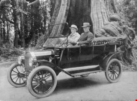
At Stanley Park
https://search.heritageburnaby.ca/link/archivedescription64486
- Repository
- City of Burnaby Archives
- Date
- 1920
- Collection/Fonds
- Burnaby Historical Society fonds
- Description Level
- Item
- Physical Description
- 1 photograph : sepia ; 12 x 16.5 cm, mounted on cardboard 20 x 25.5 cm
- Scope and Content
- Photograph of two men, possibly Lawrence (Snowball) Bailey and Wilson (Red) Bailey, parked in front of the hollow tree at Stanley Park in a touring car.
- Repository
- City of Burnaby Archives
- Date
- 1920
- Collection/Fonds
- Burnaby Historical Society fonds
- Subseries
- Bailey family subseries
- Physical Description
- 1 photograph : sepia ; 12 x 16.5 cm, mounted on cardboard 20 x 25.5 cm
- Description Level
- Item
- Record No.
- 508-014
- Access Restriction
- No restrictions
- Reproduction Restriction
- No known restrictions
- Accession Number
- BHS1992-55
- Scope and Content
- Photograph of two men, possibly Lawrence (Snowball) Bailey and Wilson (Red) Bailey, parked in front of the hollow tree at Stanley Park in a touring car.
- Subjects
- Transportation - Automobiles
- Media Type
- Photograph
- Photographer
- Stanley Park Photographers
- Notes
- Title based on contents of photograph
- Photographer's mark on recto of card mount reads: "Stanley Park / Photographers / Vancouver, B.C."
Images