Narrow Results By
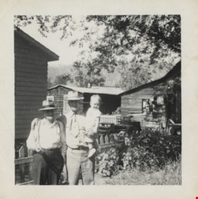
Brothers Earl and Norman Wild
https://search.heritageburnaby.ca/link/archivedescription80586
- Repository
- City of Burnaby Archives
- Collection/Fonds
- Murray family fonds
- Description Level
- Item
- Physical Description
- 1 photograph : b&w ; 7 x 7 cm
- Scope and Content
- Photograph of brothers Earl and Norman Wild in Idaho, in the United States of America (USA). Norman is holding an unidentified toddler on one arm, and has his other arm around his brother.
- Repository
- City of Burnaby Archives
- Collection/Fonds
- Murray family fonds
- Physical Description
- 1 photograph : b&w ; 7 x 7 cm
- Description Level
- Item
- Record No.
- 548-003
- Access Restriction
- No restrictions
- Reproduction Restriction
- May be restricted by third party rights
- Accession Number
- 2012-31
- Scope and Content
- Photograph of brothers Earl and Norman Wild in Idaho, in the United States of America (USA). Norman is holding an unidentified toddler on one arm, and has his other arm around his brother.
- Names
- Wild, Norman
- Wild, Earl
- Media Type
- Photograph
- Notes
- Title based on contents of photograph
- Note in blue ink on verso of photograph reads: "Norman's brother Earl + Norman. Idaho USA"
Images

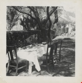
Earl Wild's property
https://search.heritageburnaby.ca/link/archivedescription80587
- Repository
- City of Burnaby Archives
- Collection/Fonds
- Murray family fonds
- Description Level
- Item
- Physical Description
- 1 photograph : b&w ; 7 x 7 cm
- Scope and Content
- Photograph of a table set outdoors on Earl Wild's property in Idaho, in the United States of America. The table is set for six people.
- Repository
- City of Burnaby Archives
- Collection/Fonds
- Murray family fonds
- Physical Description
- 1 photograph : b&w ; 7 x 7 cm
- Description Level
- Item
- Record No.
- 548-004
- Access Restriction
- No restrictions
- Reproduction Restriction
- No known restrictions
- Accession Number
- 2012-31
- Scope and Content
- Photograph of a table set outdoors on Earl Wild's property in Idaho, in the United States of America. The table is set for six people.
- Subjects
- Furniture
- Media Type
- Photograph
- Notes
- Title based on contents of photograph
- Note in blue ink on verso of photograph reads: "Wild / Earls USA"
Images

![Highways map of British Columbia, Alberta and adjacent states, [1930] thumbnail](/media/hpo/_Data/_BVM_Cartographic_Material/1977/1977_0037_0187_001.jpg?width=280)
Highways map of British Columbia, Alberta and adjacent states
https://search.heritageburnaby.ca/link/museumdescription9668
- Repository
- Burnaby Village Museum
- Date
- [1930]
- Collection/Fonds
- Burnaby Village Museum Map collection
- Description Level
- Item
- Physical Description
- 1 map : col. lithographic print ; both sides ; 89.5 x 58 cm, folded to 11.5 x 20 cm
- Scope and Content
- Double sided road map published by Imperial Oil, Ltd. and featuring the main travelled highway routes of British Columbia, Alberta and the Northwestern-most states of the United States of America. The map is a colour lithograph. The main map is green, with the highways highlighted in red. The litho…
- Repository
- Burnaby Village Museum
- Collection/Fonds
- Burnaby Village Museum Map collection
- Description Level
- Item
- Physical Description
- 1 map : col. lithographic print ; both sides ; 89.5 x 58 cm, folded to 11.5 x 20 cm
- Material Details
- Scale 1 inch = 20 miles
- A.R. THOMSON / CHIEF CARTOGRAPHER
- Scope and Content
- Double sided road map published by Imperial Oil, Ltd. and featuring the main travelled highway routes of British Columbia, Alberta and the Northwestern-most states of the United States of America. The map is a colour lithograph. The main map is green, with the highways highlighted in red. The lithograph was created in Canada by Rolph Clark Stone Ltd in Toronto. The opposite side of the map features inset maps of the following: the Trans-Canada Highway, the highway between Prince Rupert and Prince George, the highway through the Canadian Rockies, and the highway through the Peace River District. Small city plan maps of highways through major cities, as well as advertisements for Imperial Oil products, are also found on the opposite side of the main map. This map is one of four produced by Imperial Oil that covered the most populated areas of Canada from coast to coast and paralleled Imperial Oil's distribution service.
- Creator
- Thomson, A.R.
- Publisher
- Imperial Oil Limited
- Accession Code
- HV977.37.187
- Access Restriction
- No restrictions
- Reproduction Restriction
- No known restrictions
- Date
- [1930]
- Media Type
- Cartographic Material
- Scan Resolution
- 600
- Scan Date
- 2023-11-10
- Notes
- Title based on content of map
Zoomable Images
![Highways map of British Columbia, Alberta and adjacent states, [1930] thumbnail](/media/hpo/_Data/_BVM_Cartographic_Material/1977/1977_0037_0187_003_seadragon/1977_0037_0187_003.jpg?w=280)

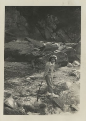
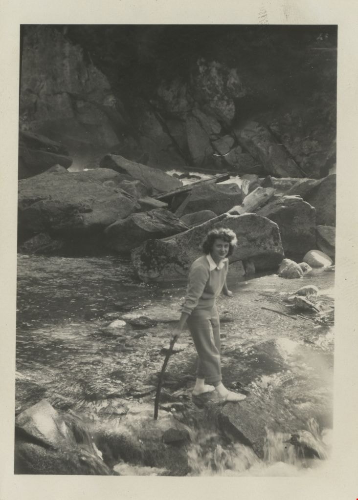
Lillian Yanko at Deception Falls
https://search.heritageburnaby.ca/link/archivedescription79342
- Repository
- City of Burnaby Archives
- Date
- July 1949
- Collection/Fonds
- Yanko family fonds
- Description Level
- Item
- Physical Description
- 1 photograph : b&w ; 8 x 5.5 cm
- Scope and Content
- Photograph of Leida Doria "Lillian Doris" (Carman) Yanko at Deception Falls in Washington State, United States of America.
- Repository
- City of Burnaby Archives
- Date
- July 1949
- Collection/Fonds
- Yanko family fonds
- Physical Description
- 1 photograph : b&w ; 8 x 5.5 cm
- Material Details
- Secured to album page with photo corners
- Description Level
- Item
- Record No.
- 545-152
- Access Restriction
- No restrictions
- Reproduction Restriction
- No restrictions
- Accession Number
- 2012-09
- Scope and Content
- Photograph of Leida Doria "Lillian Doris" (Carman) Yanko at Deception Falls in Washington State, United States of America.
- Subjects
- Geographic Features - Waterfalls
- Media Type
- Photograph
- Notes
- Title based on contents of photograph
- Note written on album page reads: "Deception Falls / Wash. USA / 4 July 1949'"
- Note in black ink on verso of photograph reads: "Deception Falls, Washington, USA / July/49"
- 1 duplicate photograph accompanying
Images