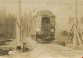
BCER Burnaby Lake Line
https://search.heritageburnaby.ca/link/landmark760
- Repository
- Burnaby Heritage Planning
- Associated Dates
- 1911
- Heritage Value
- The Burnaby Lake Line was constructed due to the advocacy of Burnaby residents and the Municipality of Burnaby to build the line. A petition was circulated by residents in 1907, and eventually substantial land bonuses were given to the company to induce them to build the line. Property owners in the area hoped the construction of the line would increase their land values. Construction of the 15-mile line was announced in 1909, and the line opened in 1911. The line travelled from Vancouver to New Westminister through central Burnaby.The last day of service was October 23, 1953. When the Trans Canada highway was constructed in the 1960s, it followed the right of way of the Burnaby Lake Line through Burnaby.
- Historic Neighbourhood
- Burnaby Lake (Historic Neighbourhood)
- Planning Study Area
- Burnaby Lake Area
Images
Willingdon Heights Neighbourhood
https://search.heritageburnaby.ca/link/landmark777
- Repository
- Burnaby Heritage Planning
- Associated Dates
- 1955-2008
- Heritage Value
- The convenient location of Willingdon Heights to the Trans Canada Highway, Lougheed Highway and Hastings Street has fostered its development as a primarily residential commuter neighbourhood. Characterised in the post-World War Two period by predominantly single-family developments, the neighbourhood has retained this identity despite some higher density apartment buildings now found there.
- Planning Study Area
- Willingdon Heights Area

