
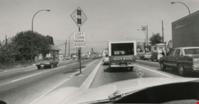
The Freeway
https://search.heritageburnaby.ca/link/archivedescription45381
- Repository
- City of Burnaby Archives
- Date
- 1973
- Collection/Fonds
- Columbian Newspaper collection
- Description Level
- Item
- Physical Description
- 1 photograph : b&w ; 16 x 24 cm
- Scope and Content
- Photograph of the Freeway (now known as the Trans Canada Highway) with Capitol Hill visible in the background.
- Repository
- City of Burnaby Archives
- Date
- 1973
- Collection/Fonds
- Columbian Newspaper collection
- Physical Description
- 1 photograph : b&w ; 16 x 24 cm
- Description Level
- Item
- Record No.
- 480-276
- Access Restriction
- No restrictions
- Reproduction Restriction
- No restrictions
- Accession Number
- 2003-02
- Scope and Content
- Photograph of the Freeway (now known as the Trans Canada Highway) with Capitol Hill visible in the background.
- Subjects
- Geographic Features - Roads
- Media Type
- Photograph
- Photographer
- King, Basil
- Notes
- Title based on contents of photograph
- Note on recto of photograph reads: "Freeway with Capitol Hill (far right)"
- Geographic Access
- Trans Canada Highway
- Historic Neighbourhood
- Burnaby Lake (Historic Neighbourhood)
Images

![Highway Improvement Project signage, [1972] thumbnail](/media/hpo/_Data/_Archives_Images/_Unrestricted/480/480-280.jpg?width=280)
Highway Improvement Project signage
https://search.heritageburnaby.ca/link/archivedescription45385
- Repository
- City of Burnaby Archives
- Date
- [1972]
- Collection/Fonds
- Columbian Newspaper collection
- Description Level
- Item
- Physical Description
- 1 photograph : b&w ; 14 x 21 cm
- Scope and Content
- Photograph of Highway Improvement Project signage (developed by the British Columbian Government under W.A.C. Bennett) along the Trans Canada Highway.
- Repository
- City of Burnaby Archives
- Date
- [1972]
- Collection/Fonds
- Columbian Newspaper collection
- Physical Description
- 1 photograph : b&w ; 14 x 21 cm
- Description Level
- Item
- Record No.
- 480-280
- Access Restriction
- No restrictions
- Reproduction Restriction
- No restrictions
- Accession Number
- 2003-02
- Scope and Content
- Photograph of Highway Improvement Project signage (developed by the British Columbian Government under W.A.C. Bennett) along the Trans Canada Highway.
- Media Type
- Photograph
- Photographer
- King, Basil
- Notes
- Title based on contents of photograph
Images
![Highway Improvement Project signage, [1972] thumbnail](/media/hpo/_Data/_Archives_Images/_Unrestricted/480/480-280.jpg)

New Freeway in Burnaby
https://search.heritageburnaby.ca/link/archivedescription45383
- Repository
- City of Burnaby Archives
- Date
- 1959
- Collection/Fonds
- Columbian Newspaper collection
- Description Level
- Item
- Physical Description
- 1 photograph : b&w ; 20.5 x 18.5 cm
- Scope and Content
- Photograph of the Lower mainland's "new freeway" in Burnaby. This was taken along the Trans Canada Highway with the Willingdon exit off to the south and the Grandview Highway off to the west.
- Repository
- City of Burnaby Archives
- Date
- 1959
- Collection/Fonds
- Columbian Newspaper collection
- Physical Description
- 1 photograph : b&w ; 20.5 x 18.5 cm
- Description Level
- Item
- Record No.
- 480-278
- Access Restriction
- No restrictions
- Reproduction Restriction
- No restrictions
- Accession Number
- 2003-02
- Scope and Content
- Photograph of the Lower mainland's "new freeway" in Burnaby. This was taken along the Trans Canada Highway with the Willingdon exit off to the south and the Grandview Highway off to the west.
- Subjects
- Geographic Features - Roads
- Media Type
- Photograph
- Photographer
- King, Basil
- Notes
- Title based on note on verso of photograph
- Note on verso of photograph reads: "Lower mainland's new freeway in Burnaby"
- Geographic Access
- Trans Canada Highway
- Historic Neighbourhood
- Broadview (Historic Neighbourhood)
- Planning Study Area
- Cascade-Schou Area
Images

New sign at Cassiar and East Hastings
https://search.heritageburnaby.ca/link/archivedescription45384
- Repository
- City of Burnaby Archives
- Date
- 1975
- Collection/Fonds
- Columbian Newspaper collection
- Description Level
- Item
- Physical Description
- 1 photograph : b&w ; 10 x 19.5 cm
- Scope and Content
- Photograph of the sign allerting drivers to the upcoming signal that had been added at the intersection of Cassiar Street and East Hastings in Vancouver to help smooth the traffic congestion coming off of the Trans Canada Highway (previously named the 401 Freeway).
- Repository
- City of Burnaby Archives
- Date
- 1975
- Collection/Fonds
- Columbian Newspaper collection
- Physical Description
- 1 photograph : b&w ; 10 x 19.5 cm
- Description Level
- Item
- Record No.
- 480-279
- Access Restriction
- No restrictions
- Reproduction Restriction
- No restrictions
- Accession Number
- 2003-02
- Scope and Content
- Photograph of the sign allerting drivers to the upcoming signal that had been added at the intersection of Cassiar Street and East Hastings in Vancouver to help smooth the traffic congestion coming off of the Trans Canada Highway (previously named the 401 Freeway).
- Subjects
- Geographic Features - Roads
- Media Type
- Photograph
- Photographer
- King, Basil
- Notes
- Title based on contents of photograph
- Newspaper clipping attached to verso of photograph reads: "SIGNAL EASES BOTTLENECK / Finally a signal has been erected at Cassiar and East Hastings which controls a left turn at that junction for traffic coming off the 401 Freeway."
Images

![Stormont Overpass, [1978] thumbnail](/media/hpo/_Data/_Archives_Images/_Unrestricted/480/480-275.jpg?width=280)
Stormont Overpass
https://search.heritageburnaby.ca/link/archivedescription45380
- Repository
- City of Burnaby Archives
- Date
- [1978]
- Collection/Fonds
- Columbian Newspaper collection
- Description Level
- Item
- Physical Description
- 1 photograph : b&w ; 16 x 24 cm
- Scope and Content
- Aerial photograph of Stormont Overpass which would provide a direct link from the Trans Canada Highway (previously named the 401 Freeway) to the Lougheed Highway and Simon Fraser University. This was taken when the excavation work was completed, and paving still need to be done.
- Repository
- City of Burnaby Archives
- Date
- [1978]
- Collection/Fonds
- Columbian Newspaper collection
- Physical Description
- 1 photograph : b&w ; 16 x 24 cm
- Description Level
- Item
- Record No.
- 480-275
- Access Restriction
- No restrictions
- Reproduction Restriction
- No restrictions
- Accession Number
- 2003-02
- Scope and Content
- Aerial photograph of Stormont Overpass which would provide a direct link from the Trans Canada Highway (previously named the 401 Freeway) to the Lougheed Highway and Simon Fraser University. This was taken when the excavation work was completed, and paving still need to be done.
- Media Type
- Photograph
- Photographer
- King, Basil
- Notes
- Title based on contents of photograph
- Note on verso of photograph reads: "One of the biggest Highways"
- Geographic Access
- Cariboo Road
- Gaglardi Way
- Trans Canada Highway
- Historic Neighbourhood
- Burquitlam (Historic Neighbourhood)
- Planning Study Area
- Burnaby Lake Area
- Cameron Area
Images
![Stormont Overpass, [1978] thumbnail](/media/hpo/_Data/_Archives_Images/_Unrestricted/480/480-275.jpg)